
| PINCKNEYVILLE-DU QUOIN PINCKNEYVILLE IL |
| |
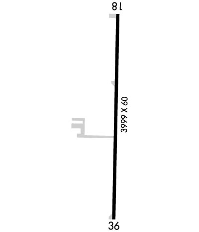
| Lat: N 3758.7 Long: W 08921.6 Elev: 400 Var: -00 Longest Runway: 3999 | ||
| CTAF: 122.8 | ||
| ||||||||||||||||||||||||||||||||
| ||||||||||||||||||||||||||||||||
| Rwy | Rwy | |||||||
| 3999x60 | 3999' | 3999x60 | 3999' | |||||
| Runway ID | Single Wheel | Double Wheel | Double Tandem Wheel | Dual Double Wheel |
| 18/36 | 12,500 | 15,800 | N/A | N/A |
| These numbers are Advisory and are not limits. The Airport Manager should have more accurate Weight Limits | ||||
 Airport Diagram might not be current. | |
| Facility Name: | PINCKNEYVILLE-DU QUOIN |
| City Name: | PINCKNEYVILLE |
| County: | PERRY |
| State abbrev: | IL |
| State Name: | ILLINOIS |
| Ownership: | PUBLICLY OWNED |
| Use: | OPEN TO THE PUBLIC |
| Owner's Name: | CITIES OF DU QUOIN/PINCKNEYVILLE |
| Address: | P.O. BOX 147 |
| PINCKNEYVILLE, IL 62274 | |
| Owner's Phone: | 618-357-6916 |
| Manager's Name: | STEPHEN MOSS |
| Address: | 721 PAWNEE DRIVE |
| DU QUOIN, IL 62832-2557 | |
| Phone: | 618-542-8596 |
| FAA Region: | GREAT LAKES |
| FAA Field Office: | CHI |

| Date | Sunrise | Sunset |
|---|---|---|
| 09/24/21 Friday | 6:47 | 18:52 |
| 09/25/21 Saturday | 6:48 | 18:50 |
| 09/26/21 Sunday | 6:48 | 18:49 |
| 09/27/21 Monday | 6:49 | 18:47 |
| 09/28/21 Tuesday | 6:50 | 18:45 |
| 09/29/21 Wednesday | 6:51 | 18:44 |
| 09/30/21 Thursday | 6:52 | 18:42 |
| 10/01/21 Friday | 6:53 | 18:41 |
| 10/02/21 Saturday | 6:54 | 18:39 |
| 10/03/21 Sunday | 6:55 | 18:38 |
| 10/04/21 Monday | 6:56 | 18:36 |
| 10/05/21 Tuesday | 6:56 | 18:35 |
| 10/06/21 Wednesday | 6:57 | 18:33 |
| 10/07/21 Thursday | 6:58 | 18:32 |
| Airport Attendance Schedule | IRREGULAR |
| Airport Status | OPERATIONAL (This Status can change at any time - please check NOTAMS) |
| Airport Lighting Schedule | ACTVT REIL RWY 18 & 36. MIRL RWY 18/36 PRESET TO LOW INTST, TO INCR INTST & ACTVT - CTAF. |
| Airport Storage Available | Tie Downs, Hanger |
| Extra Services Available | Flight Instruction, Aircraft Rental |
| Wind Indicator | YES - (lighted) |
| Control Tower | NO |
| CTAF Frequency | 122.800 |
| Unicom Frequency | 122.800 |
| Rotating Beacon Color | CLEAR-GREEN (Light Land Airport) |
| Segmented Circle | NO |
| Landing Fee |
| Airport Inspected | STATE - performed by STATE AERONAUTICAL PERSONNEL |
| Inspection Date | 05/12/2021 |
| Type of Fuel Available | Grade 100LL |
| Airframe Repair Service | None |
| Power Plant Repair Service | None |
| Latitude | N3758.7 |
| Longitude | W08921.6 (ESTIMATED) |
| Arpt Elevation | 400ft (SURVEYED) |
| Magnetic Variation | 00E |
| 6 miles SE | of PINCKNEYVILLE |
| Traffic Pattern Altitude | 400; TPA: 400 FT AGL ULTRALIGHTS, 800 FT AGL ALL OTR ACFT. |
| Sectional Chart | ST LOUIS |
| Operations (Reported) | Yearly | Avg. Daily |
|---|---|---|
| General Aviation Transient | 4000 | 11 |
| General Aviation Local | 4000 | 11 |
| Air Taxi | 0 | 0 |
| Commerical | 0 | 0 |
| Commuter | 0 | 0 |
| Military | 0 | 0 |
| Aircraft based on Field | |
|---|---|
| General Aviation Singles | 16 |
| General Aviation Multi | 0 |
| Jet Aircraft | 0 |
| General Aviation Helicopters | 0 |
| Military Aircraft | 0 |
| Gliders | 0 |
| Ultralights | 0 |
| FSS on field | NO |
| FSS tie-in | SAINT LOUIS |
| FSS Phone | 1-800-WX-BRIEF |
| Who issues Notams | STL |
| Notam D service at airport | YES |
| ARTCC Name | KANSAS CITY |
| Airport Certification | |
| Aircraft Rescue & Firefighting Index | None |
| Airport of Entry | No |
| Custom Landing Rights | No |
| Joint Civil/Military | No |
| Military Landing rights | YES |
| NATIONAL PLAN OF INTEGRATED AIRPORT SYSTEMS (NPIAS) |
| GRANT AGREEMENTS UNDER FAAP/ADAP/AIP |
| ASSURANCES PURSUANT TO TITLE VI, CIVIL RIGHTS ACT OF 1964 |
| FOR SVC CALL ACFT MAINT, 618-443-2002. |
| ULTRALIGHT OPS ON AND INVOF ARPT. |
| WILDLIFE ON & INVOF ARPT. |
| FUEL IS SELF SVC WITH CREDIT CARD. |
| FOR EMERG CALL POLICE DEPT 618-357-8231 OR 911. |
| ULTRALIGHT TKOF AND LDG OPS ON GRASS ON WEST SIDE OF RWY. |
| FOR CD CTC KANSAS CITY ARTCC AT 913-254-8508. |
Airport Communications & Frequencies:
| |||||||||
| Runway: 18 | Runway: 36 | ||
| Mag heading: | 181° | Mag heading: | 1° |
| Rwy Slope: | -.16% Down | Rwy Slope: | .16% Up |
| Approach: | Approach: | ||
| Pattern: | Left Traffic | Pattern: | Left Traffic |
| Markings: | NONPRECISION INSTRUMENT | Markings: | NONPRECISION INSTRUMENT |
| Marking Condition: | GOOD | Marking Condition: | GOOD |
| Arresting Dev: | Arresting Dev: | ||
| Lat & Long: | N3759.0 W08921.6 | Lat. & Long.: | N3758.3 W08921.6 |
| Elev: | 400.4 ft. MSL | Elev: | 394.0 ft. MSL |
| TCH: | 44 ft. AGL | TCH: | 44 ft. AGL |
| Visual Glide Path: | 3.00 degrees | Visual Glide Path: | 3.00 degrees |
| Displaced Threshold: | No | Displaced Threshold: | No |
| Touchdown Zone: | YES | Touchdown Zone: | YES |
| Touchdown Elev.: | 400.4 feet | Touchdown Elev.: | 394.3 feet |
| Visual Glide Slope: | 2-Light PAPI on LEFT side of Runway; RWY 18 PAPI UNUSBL BYD 1 NM. | Visual Glide Slope: | 2-Light PAPI on LEFT side of Runway |
| RVR Equipment: | RVR Equipment: | ||
| RVV Equipment: | NO | RVV Equipment: | NO |
| Approach Lights: | Approach Lights: | ||
| REIL: | YES | REIL: | YES |
| Centerline Lights: | NO | Centerline Lights: | NO |
| Touchdown lights: | NO | Touchdown lights: | NO |
| Runway Category: | Runway with a Non-precision Approach | Runway Category: | Runway with a Non-precision Approach |
| Declared Distances: | Declared Distances: | ||
| Obstructions: | Obstructions: | ROAD | |
| Marked: | Marked: | NOT Marked/Lighted | |
| Clearance slope: | 20:1 | Clearance slope: | 20:1 |
| Obstruction height: | Obstruction height: | 14 feet AGL | |
| Dist. from runway: | Dist. from runway: | 488 feet | |
| Centerline offset: | Centerline offset: | 293 feet left of centerline | |
| Comments: | Comments: |
Thanks for using FltPlan.com
all rights reserved © 1999-2021 by Flight Plan LLC