| PIERRE RGNL PIERRE SD |
| |
| Lat: N 4423.0 Long: W 10017.2 Elev: 1744 Var: -08 Longest Runway: 6900 | ||
| AWOS: 119.02 CTAF: 122.7 | ||
| |||||||||||||||||||||||||||||||||||||||||||||||||||||||||||||||||||||
| |||||||||||||||||||||||||||||||||||||||||||||||||||||||||||||||||||||
| |||||||||||||||||||||||||||||||||||||||||||||||||||||||||||||||||||||
| Rwy | Rwy | |||||||
| 6880x150 | 6880' | 6880x150 | 6880' | |||||
| 6900x100 | 6900' | 6900x100 | 6900' | 111.90 - 312° | ||||
| Runway ID | Single Wheel | Double Wheel | Double Tandem Wheel | Dual Double Wheel |
| 07/25 | 91,000 | 114,000 | 180,000 | N/A |
| 13/31 | 91,000 | 108,000 | 168,000 | N/A |
| These numbers are Advisory and are not limits. The Airport Manager should have more accurate Weight Limits | ||||
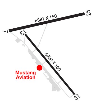 Airport Diagram might not be current. | |
| Facility Name: | PIERRE RGNL |
| City Name: | PIERRE |
| County: | HUGHES |
| State abbrev: | SD |
| State Name: | SOUTH DAKOTA |
| Ownership: | PUBLICLY OWNED |
| Use: | OPEN TO THE PUBLIC |
| Owner's Name: | CITY OF PIERRE |
| Address: | 3800 AIRPORT ROAD, SUITE 209 |
| PIERRE, SD 57501 | |
| Owner's Phone: | 605-773-7447 |
| Manager's Name: | CAMERON HOWARD |
| Address: | 3800 AIRPORT ROAD, SUITE 209 |
| PIERRE, SD 57501 | |
| Phone: | 605-773-7447 |
| FAA Region: | GREAT LAKES |
| FAA Field Office: | DMA |
| Date | Sunrise | Sunset |
|---|---|---|
| 09/24/21 Friday | 7:30 | 19:35 |
| 09/25/21 Saturday | 7:32 | 19:33 |
| 09/26/21 Sunday | 7:33 | 19:31 |
| 09/27/21 Monday | 7:34 | 19:30 |
| 09/28/21 Tuesday | 7:35 | 19:28 |
| 09/29/21 Wednesday | 7:36 | 19:26 |
| 09/30/21 Thursday | 7:37 | 19:24 |
| 10/01/21 Friday | 7:39 | 19:22 |
| 10/02/21 Saturday | 7:40 | 19:20 |
| 10/03/21 Sunday | 7:41 | 19:19 |
| 10/04/21 Monday | 7:42 | 19:17 |
| 10/05/21 Tuesday | 7:44 | 19:15 |
| 10/06/21 Wednesday | 7:45 | 19:13 |
| 10/07/21 Thursday | 7:46 | 19:11 |
| Airport Attendance Schedule | MON-FRI 0500-2400, SAT-SUN 0500-2200; FOR ATTENDANT OTHER TIMES CALL 605-224-9000/8621. |
| Airport Status | OPERATIONAL (This Status can change at any time - please check NOTAMS) |
| Airport Lighting Schedule | ACTVT MALSR RWY 31; REIL RWY 07, 13, 25; PAPI RWY 07, 25, 13 & 31; HIRL RWY 07/25 & 13/31 -CTAF. |
| Airport Storage Available | Tie Downs, Hanger |
| Extra Services Available | Air Freight, Crop Dusting, Air Ambulance, Charter, Flight Instruction, Aircraft Rental, Aircraft Sales |
| Wind Indicator | YES - (lighted) |
| Control Tower | NO |
| CTAF Frequency | 122.700 |
| Unicom Frequency | 122.950 |
| Rotating Beacon Color | CLEAR-GREEN (Light Land Airport) |
| Segmented Circle | YES |
| Landing Fee | NO; NO |
| Airport Inspected | FEDERAL - performed by FAA AIRPORTS FIELD PERSONNEL |
| Inspection Date | 09/13/2019 |
| Type of Fuel Available | Grade 100LL, JET A (freeze point -40C) |
| Airframe Repair Service | MAJOR |
| Power Plant Repair Service | MAJOR |
| Latitude | N4423.0 |
| Longitude | W10017.2 (ESTIMATED) |
| Arpt Elevation | 1744ft (SURVEYED) |
| Magnetic Variation | 08E |
| 3 miles E | of PIERRE |
| Traffic Pattern Altitude | |
| Sectional Chart | OMAHA |
| Operations (Reported) | Yearly | Avg. Daily |
|---|---|---|
| General Aviation Transient | 15000 | 41 |
| General Aviation Local | 7500 | 21 |
| Air Taxi | 7500 | 21 |
| Commerical | 1460 | 4 |
| Commuter | 0 | 0 |
| Military | 500 | 1 |
| Aircraft based on Field | |
|---|---|
| General Aviation Singles | 47 |
| General Aviation Multi | 14 |
| Jet Aircraft | 1 |
| General Aviation Helicopters | 1 |
| Military Aircraft | 0 |
| Gliders | 0 |
| Ultralights | 0 |
| FSS on field | NO |
| FSS tie-in | HURON |
| FSS Phone | 1-800-WX-BRIEF |
| Who issues Notams | PIR |
| Notam D service at airport | YES |
| ARTCC Name | MINNEAPOLIS |
| Airport Certification | AIRPORT RECEIVING SCHEDULED AIR CARRIER SERVICE FROM CARRIERS CERTIFICATED BY THE CIVIL AERONAUTICS BOARD; 48 HOUR PPR FOR UNSKED ACR OPNS INVOLVING ACFT DESIGNED FOR 31 OR MORE PAX SEATS CALL 605-773-7447 OR 605-773-7405. |
| Aircraft Rescue & Firefighting Index | AIRPORT HAS A CERTIFICATE UNDER CFR PART 139 |
| Airport of Entry | No |
| Custom Landing Rights | No |
| Joint Civil/Military | No |
| Military Landing rights | YES |
| NATIONAL PLAN OF INTEGRATED AIRPORT SYSTEMS (NPIAS) |
| GRANT AGREEMENTS UNDER FAAP/ADAP/AIP |
| SURPLUS PROPERTY AGREEMENT UNDER PUBLIC LAW 289 |
| ASSURANCES PURSUANT TO TITLE VI, CIVIL RIGHTS ACT OF 1964 |
| BIRDS ON & INVOF ARPT & WITHIN A 25 NM RADIUS. |
| TWY C IS 50 FT WIDE & RSTRD TO ACFT 75000 LBS OR LESS. |
| NO LINE OF SIGHT BTN RY ENDS OF RY 07/25. |
| ARPT COND UNMONITORED DURING 2200-0600 MON-FRI; 1300 SAT - 1300 SUN. |
| AIR CARRIER LANDING FEE $14 + $1 PER 1000 LBS OVER 20K LBS |
| FOR CD IF UNA TO CTC ON FSS FREQ, CTC MINNEAPOLIS ARTCC AT 651-463-5588. |
Airport Communications & Frequencies:
| |||||||||
| Runway: 07 | Runway: 25 | ||
| Mag heading: | 69° | Mag heading: | 249° |
| Rwy Slope: | -.61% Down | Rwy Slope: | .61% Up |
| Approach: | Approach: | ||
| Pattern: | Left Traffic | Pattern: | Left Traffic |
| Markings: | NONPRECISION INSTRUMENT | Markings: | NONPRECISION INSTRUMENT |
| Marking Condition: | GOOD | Marking Condition: | GOOD |
| Arresting Dev: | Arresting Dev: | ||
| Lat & Long: | N4423.1 W10018.0 | Lat. & Long.: | N4423.4 W10016.4 |
| Elev: | 1744.3 ft. MSL | Elev: | 1702.6 ft. MSL |
| TCH: | 46 ft. AGL | TCH: | 53 ft. AGL |
| Visual Glide Path: | 3.00 degrees | Visual Glide Path: | 3.00 degrees |
| Displaced Threshold: | No | Displaced Threshold: | No |
| Touchdown Zone: | YES | Touchdown Zone: | YES |
| Touchdown Elev.: | 1744.3 feet | Touchdown Elev.: | 1725.4 feet |
| Visual Glide Slope: | 4-Light PAPI on LEFT side of Runway | Visual Glide Slope: | 4-Light PAPI on LEFT side of Runway |
| RVR Equipment: | RVR Equipment: | ||
| RVV Equipment: | NO | RVV Equipment: | NO |
| Approach Lights: | Approach Lights: | ||
| REIL: | YES | REIL: | YES |
| Centerline Lights: | NO | Centerline Lights: | NO |
| Touchdown lights: | NO | Touchdown lights: | NO |
| Runway Category: | Runway with a Non-precision Approach having visibility minimums greater than 3/4 mile | Runway Category: | Runway with a Non-precision Approach having visibility minimums greater than 3/4 mile |
| Declared Distances: | TORA:6880' TODA:6880' ASDA:6830' LDA:6830' | Declared Distances: | TORA:6880' TODA:6880' ASDA:6880' LDA:6880' |
| Obstructions: | TANK | Obstructions: | |
| Marked: | LIGHTED | Marked: | |
| Clearance slope: | 37:1 | Clearance slope: | 50:1 |
| Obstruction height: | 79 feet AGL | Obstruction height: | |
| Dist. from runway: | 3158 feet | Dist. from runway: | |
| Centerline offset: | 548 left of centerline | Centerline offset: | |
| Comments: | Comments: |
| Runway: 13 | Runway: 31 | ||
| Mag heading: | 133° | Mag heading: | 313° |
| Rwy Slope: | -.19% Down | Rwy Slope: | .19% Up |
| Approach: | Approach: | ILS/DME | |
| Pattern: | Left Traffic | Pattern: | Left Traffic |
| Markings: | PRECISION INSTRUMENT | Markings: | PRECISION INSTRUMENT |
| Marking Condition: | GOOD | Marking Condition: | GOOD |
| Arresting Dev: | Arresting Dev: | ||
| Lat & Long: | N4423.1 W10017.6 | Lat. & Long.: | N4422.2 W10016.6 |
| Elev: | 1730.8 ft. MSL | Elev: | 1717.7 ft. MSL |
| TCH: | 52 ft. AGL | TCH: | 55 ft. AGL |
| Visual Glide Path: | 3.00 degrees | Visual Glide Path: | 3.00 degrees |
| Displaced Threshold: | No | Displaced Threshold: | No |
| Touchdown Zone: | YES | Touchdown Zone: | YES |
| Touchdown Elev.: | 1730.8 feet | Touchdown Elev.: | 1719.7 feet |
| Visual Glide Slope: | 4-Light PAPI on LEFT side of Runway | Visual Glide Slope: | 4-Light PAPI on LEFT side of Runway |
| RVR Equipment: | RVR Equipment: | ||
| RVV Equipment: | NO | RVV Equipment: | NO |
| Approach Lights: | Approach Lights: | MALSR - 1,400 foot medium intensity approach lighting system with runway alignment indicator lights | |
| REIL: | YES | REIL: | NO |
| Centerline Lights: | NO | Centerline Lights: | NO |
| Touchdown lights: | NO | Touchdown lights: | NO |
| Runway Category: | D | Runway Category: | Precision Instrument Runway |
| Declared Distances: | TORA:6900' TODA:6900' ASDA:6900' LDA:6900' | Declared Distances: | TORA:6900' TODA:6900' ASDA:6900' LDA:6900' |
Thanks for using FltPlan.com
all rights reserved © 1999-2021 by Flight Plan LLC