
| PORT ISABEL-CAMERON COUNTY PORT ISABEL TX |
| |
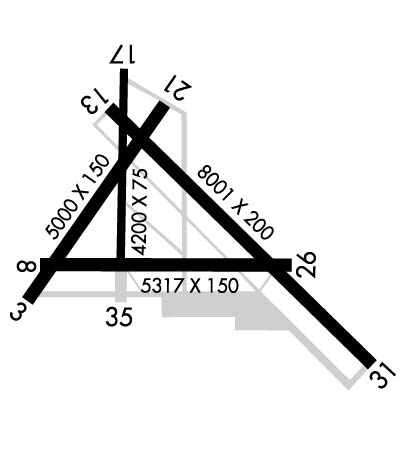
| Lat: N 2610.0 Long: W 09720.8 Elev: 19 Var: -05 Longest Runway: 8001 | ||
| Clr Del: 119.2 CTAF: 122.8 | ||
| ||||||||||||||||||||||||||||||||||||||||||||
| ||||||||||||||||||||||||||||||||||||||||||||
| ||||||||||||||||||||||||||||||||||||||||||||
| Rwy | Rwy | |||||||
| 5000x150 | 5000' | 5000x150 | 5000' | |||||
| 5317x150 | 5317' | 5317x150 | 5317' | |||||
| 8001x200 | 8001' | 8001x200 | 8001' | |||||
| 4200x75 | 4200' | 4200x75 | 4200' | |||||
| Runway ID | Single Wheel | Double Wheel | Double Tandem Wheel | Dual Double Wheel |
| 03/21 | 30,000 | 45,000 | 90,000 | N/A |
| 08/26 | 50,000 | 60,000 | 110,000 | N/A |
| 13/31 | 105,000 | 135,000 | 230,000 | N/A |
| 17/35 | 30,000 | 45,000 | 90,000 | N/A |
| These numbers are Advisory and are not limits. The Airport Manager should have more accurate Weight Limits | ||||
 Airport Diagram might not be current. | |
| Facility Name: | PORT ISABEL-CAMERON COUNTY |
| City Name: | PORT ISABEL |
| County: | CAMERON |
| State abbrev: | TX |
| State Name: | TEXAS |
| Ownership: | PUBLICLY OWNED |
| Use: | OPEN TO THE PUBLIC |
| Owner's Name: | CAMERON COUNTY |
| Address: | COUNTY COURTHOUSE, 1100 E. MONROE |
| BROWNSVILLE, TX 78520 | |
| Owner's Phone: | 956-544-0830 |
| Manager's Name: | JOE VEGA |
| Address: | 33174 STATE PARK RD 100 SOUTH |
| SOUTH PADRE ISLAND, TX 78597 | |
| Phone: | (956) 761-3700; FAX 956-761-5317 |
| FAA Region: | SOUTHWEST |
| FAA Field Office: | TEX |
| Date | Sunrise | Sunset |
|---|---|---|
| 09/24/21 Friday | 7:19 | 19:24 |
| 09/25/21 Saturday | 7:19 | 19:23 |
| 09/26/21 Sunday | 7:20 | 19:22 |
| 09/27/21 Monday | 7:20 | 19:20 |
| 09/28/21 Tuesday | 7:20 | 19:19 |
| 09/29/21 Wednesday | 7:21 | 19:18 |
| 09/30/21 Thursday | 7:21 | 19:17 |
| 10/01/21 Friday | 7:22 | 19:16 |
| 10/02/21 Saturday | 7:22 | 19:15 |
| 10/03/21 Sunday | 7:23 | 19:14 |
| 10/04/21 Monday | 7:23 | 19:13 |
| 10/05/21 Tuesday | 7:23 | 19:12 |
| 10/06/21 Wednesday | 7:24 | 19:11 |
| 10/07/21 Thursday | 7:24 | 19:10 |
| Airport Attendance Schedule | 7 Days A Week 0800-1700 |
| Airport Status | OPERATIONAL (This Status can change at any time - please check NOTAMS) |
| Airport Lighting Schedule | SS-SR |
| Airport Storage Available | Tie Downs, Hanger |
| Extra Services Available | Cargo Handling, Charter, Flight Instruction, Parachute Jumping, Aircraft Rental, Aircraft Sales |
| Wind Indicator | YES - (unlit) |
| Control Tower | NO |
| CTAF Frequency | 122.800 |
| Unicom Frequency | 122.800 |
| Rotating Beacon Color | CLEAR-GREEN (Light Land Airport) |
| Segmented Circle | YES |
| Landing Fee | NO |
| Airport Inspected | STATE - performed by PRIVATE CONTRACT PERSONNEL |
| Inspection Date | 01/13/2017 |
| Type of Fuel Available | Grade 100LL, JET A (freeze point -40C); -10FUEL SELF SERVE WITH CREDIT CARD. |
| Airframe Repair Service | MINOR |
| Power Plant Repair Service | MINOR |
| Latitude | N2610.0 |
| Longitude | W09720.8 (ESTIMATED) |
| Arpt Elevation | 18ft (SURVEYED) |
| Magnetic Variation | 05E |
| 10 miles NW | of PORT ISABEL |
| Traffic Pattern Altitude | |
| Sectional Chart | BROWNSVILLE |
| Operations (Reported) | Yearly | Avg. Daily |
|---|---|---|
| General Aviation Transient | 11000 | 30 |
| General Aviation Local | 2400 | 7 |
| Air Taxi | 20 | 0 |
| Commerical | 0 | 0 |
| Commuter | 0 | 0 |
| Military | 16000 | 44 |
| Aircraft based on Field | |
|---|---|
| General Aviation Singles | 16 |
| General Aviation Multi | 3 |
| Jet Aircraft | 0 |
| General Aviation Helicopters | 1 |
| Military Aircraft | 0 |
| Gliders | 0 |
| Ultralights | 0 |
| FSS on field | NO |
| FSS tie-in | SAN ANGELO |
| FSS Phone | 1-800-WX-BRIEF |
| Who issues Notams | PIL |
| Notam D service at airport | YES |
| ARTCC Name | HOUSTON |
| Airport Certification | |
| Aircraft Rescue & Firefighting Index | None |
| Airport of Entry | No |
| Custom Landing Rights | No |
| Joint Civil/Military | No |
| Military Landing rights | YES |
| NATIONAL PLAN OF INTEGRATED AIRPORT SYSTEMS (NPIAS) |
| SURPLUS PROPERTY AGREEMENT UNDER PUBLIC LAW 289 |
| ASSURANCES PURSUANT TO TITLE VI, CIVIL RIGHTS ACT OF 1964 |
| NO POSITION HOLDING MARKINGS ON NUMEROUS TWYS APPROACHING RY INTERSECTIONS. |
| LOOSE GRAVEL/PAVEMENT AT INTERSECTION OF RY 13 & NORTHEAST TWY CONNECTING RYS 13 & 21. |
| FOR CD CTC CORPUS CHRISTI APCH AT 361-299-4230. |
| RWY 03/2 1 PAVEMENT HAS HVY GRASS ENCROACHMENT. |
| RWY 08/2 6 ROUGH PAVEMENT WITH HVY GRASS ENCROACHMENT. |
Airport Communications & Frequencies:
| ||||||||||||||||
| Runway: 03 | Runway: 21 | ||
| Mag heading: | 30° | Mag heading: | 210° |
| Rwy Slope: | -.02% Down | Rwy Slope: | .02% Up |
| Approach: | Approach: | ||
| Pattern: | Left Traffic | Pattern: | Left Traffic |
| Markings: | NUMBERS ONLY | Markings: | NUMBERS ONLY |
| Marking Condition: | POOR; MARKINGS FADED | Marking Condition: | POOR; MARKINGS FADED. |
| Arresting Dev: | Arresting Dev: | ||
| Lat & Long: | N2609.7 W09721.3 | Lat. & Long.: | N2610.4 W09720.8 |
| Elev: | 12.8 ft. MSL | Elev: | 11.6 ft. MSL |
| TCH: | TCH: | ||
| Visual Glide Path: | Visual Glide Path: | ||
| Displaced Threshold: | No | Displaced Threshold: | No |
| Touchdown Zone: | YES | Touchdown Zone: | YES |
| Touchdown Elev.: | 13.9 feet | Touchdown Elev.: | 14.7 feet |
| Visual Glide Slope: | Visual Glide Slope: | ||
| RVR Equipment: | RVR Equipment: | ||
| RVV Equipment: | NO | RVV Equipment: | NO |
| Approach Lights: | Approach Lights: | ||
| REIL: | NO | REIL: | NO |
| Centerline Lights: | NO | Centerline Lights: | NO |
| Touchdown lights: | NO | Touchdown lights: | NO |
| Runway Category: | Runway with a Visual Approach | Runway Category: | Runway with a Visual Approach |
| Declared Distances: | Declared Distances: | ||
| Obstructions: | BRUSH | Obstructions: | BRUSH |
| Marked: | NOT Marked/Lighted | Marked: | NOT Marked/Lighted |
| Clearance slope: | 35:1 | Clearance slope: | 3:1 |
| Obstruction height: | 12 feet AGL | Obstruction height: | 5 feet AGL |
| Dist. from runway: | 630 feet | Dist. from runway: | 216 feet |
| Centerline offset: | Centerline offset: | ||
| Comments: | Comments: |
| Runway: 08 | Runway: 26 | ||
| Mag heading: | 85° | Mag heading: | 265° |
| Rwy Slope: | .08% Up | Rwy Slope: | -.08% Down |
| Approach: | Approach: | ||
| Pattern: | Left Traffic | Pattern: | Left Traffic |
| Markings: | NUMBERS ONLY | Markings: | NUMBERS ONLY |
| Marking Condition: | FAIR; MARKINGS FADED. | Marking Condition: | FAIR; MARKINGS FADED. |
| Arresting Dev: | Arresting Dev: | ||
| Lat & Long: | N2609.8 W09721.2 | Lat. & Long.: | N2609.8 W09720.3 |
| Elev: | 12.6 ft. MSL | Elev: | 16.9 ft. MSL |
| TCH: | TCH: | ||
| Visual Glide Path: | Visual Glide Path: | ||
| Displaced Threshold: | No | Displaced Threshold: | No |
| Touchdown Zone: | YES | Touchdown Zone: | YES |
| Touchdown Elev.: | 17.0 feet | Touchdown Elev.: | 18.3 feet |
| Visual Glide Slope: | Visual Glide Slope: | ||
| RVR Equipment: | RVR Equipment: | ||
| RVV Equipment: | NO | RVV Equipment: | NO |
| Approach Lights: | Approach Lights: | ||
| REIL: | NO | REIL: | NO |
| Centerline Lights: | NO | Centerline Lights: | NO |
| Touchdown lights: | NO | Touchdown lights: | NO |
| Runway Category: | Runway with a Visual Approach | Runway Category: | Runway with a Visual Approach |
| Declared Distances: | Declared Distances: | ||
| Obstructions: | FENCE | Obstructions: | TREES |
| Marked: | NOT Marked/Lighted | Marked: | NOT Marked/Lighted |
| Clearance slope: | 16:1 | Clearance slope: | 3:1 |
| Obstruction height: | 8 feet AGL | Obstruction height: | 20 feet AGL |
| Dist. from runway: | 330 feet | Dist. from runway: | 269 feet |
| Centerline offset: | 261 left of centerline | Centerline offset: | 250 feet right of centerline |
| Comments: | 3 FT HAY BALES 129 FT FM THR, 69 FT LEFT OF CNTRLN. | Comments: |
| Runway: 13 | Runway: 31 | ||
| Mag heading: | 130° | Mag heading: | 310° |
| Rwy Slope: | .06% Up | Rwy Slope: | -.06% Down |
| Approach: | Approach: | ||
| Pattern: | Left Traffic | Pattern: | Left Traffic |
| Markings: | NONPRECISION INSTRUMENT | Markings: | NONPRECISION INSTRUMENT |
| Marking Condition: | GOOD | Marking Condition: | GOOD |
| Arresting Dev: | Arresting Dev: | ||
| Lat & Long: | N2610.4 W09721.0 | Lat. & Long.: | N2609.4 W09720.0 |
| Elev: | 13.9 ft. MSL | Elev: | 18.4 ft. MSL |
| TCH: | 27 ft. AGL | TCH: | 41 ft. AGL |
| Visual Glide Path: | 2.00 degrees | Visual Glide Path: | 3.00 degrees |
| Displaced Threshold: | No | Displaced Threshold: | No |
| Touchdown Zone: | YES | Touchdown Zone: | YES |
| Touchdown Elev.: | 17.9 feet | Touchdown Elev.: | 18.6 feet |
| Visual Glide Slope: | 2-Light PAPI on LEFT side of Runway | Visual Glide Slope: | 2-Light PAPI on LEFT side of Runway |
| RVR Equipment: | RVR Equipment: | ||
| RVV Equipment: | NO | RVV Equipment: | NO |
| Approach Lights: | Approach Lights: | ||
| REIL: | YES; REIL OTS. | REIL: | YES; REIL OTS. |
| Centerline Lights: | NO | Centerline Lights: | NO |
| Touchdown lights: | NO | Touchdown lights: | NO |
| Runway Category: | Runway with a Non-precision Approach having visibility minimums greater than 3/4 mile | Runway Category: | Runway with a Visual Approach |
| Declared Distances: | Declared Distances: | ||
| Comments: | Comments: | 4 FT HAY BALES 124 FT FM THR, 141 FT RIGHT OF CNTRLN. |
| Runway: 17 | Runway: 35 | ||
| Mag heading: | 175° | Mag heading: | 355° |
| Rwy Slope: | .08% Up | Rwy Slope: | -.08% Down |
| Approach: | Approach: | ||
| Pattern: | Left Traffic | Pattern: | Left Traffic |
| Markings: | BASIC | Markings: | BASIC |
| Marking Condition: | GOOD | Marking Condition: | GOOD |
| Arresting Dev: | Arresting Dev: | ||
| Lat & Long: | N2610.5 W09720.9 | Lat. & Long.: | N2609.8 W09720.9 |
| Elev: | 12.6 ft. MSL | Elev: | 16.0 ft. MSL |
| TCH: | TCH: | ||
| Visual Glide Path: | Visual Glide Path: | ||
| Displaced Threshold: | No | Displaced Threshold: | No |
| Touchdown Zone: | YES | Touchdown Zone: | YES |
| Touchdown Elev.: | 14.7 feet | Touchdown Elev.: | 16.0 feet |
| Visual Glide Slope: | Visual Glide Slope: | ||
| RVR Equipment: | RVR Equipment: | ||
| RVV Equipment: | NO | RVV Equipment: | NO |
| Approach Lights: | Approach Lights: | ||
| REIL: | NO | REIL: | NO |
| Centerline Lights: | NO | Centerline Lights: | NO |
| Touchdown lights: | NO | Touchdown lights: | NO |
| Runway Category: | Runway with a Visual Approach | Runway Category: | Runway with a Visual Approach |
| Declared Distances: | Declared Distances: | ||
| Obstructions: | Obstructions: | TOWER | |
| Marked: | Marked: | NOT Marked/Lighted | |
| Clearance slope: | 50:1 | Clearance slope: | 13:1 |
| Obstruction height: | Obstruction height: | 273 feet AGL | |
| Dist. from runway: | Dist. from runway: | 4000 feet | |
| Centerline offset: | Centerline offset: | 605 feet left of centerline | |
| Comments: | Comments: |
Thanks for using FltPlan.com
all rights reserved © 1999-2021 by Flight Plan LLC
