
| POCATELLO RGNL POCATELLO ID |
| |
| Lat: N 4254.6 Long: W 11235.8 Elev: 4452 Var: -14 Longest Runway: 9059 | ||
| Dept. ATIS: 135.62 Arr. ATIS: 135.62 AWOS: 135.62 Ground: 121.9 Tower: 119.1 | ||
| ||||||||||||||||||||||||||||||||||||||||||||
| ||||||||||||||||||||||||||||||||||||||||||||
| ||||||||||||||||||||||||||||||||||||||||||||
| Rwy | Rwy | |||||||
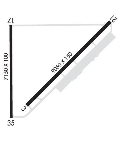
| 9059x150 | 9059' | 9059x150 | 9059' | 110.30 - 210° | ||||
| 7150x100 | 7150' | 7150x100 | 7150' | |||||
| Runway ID | Single Wheel | Double Wheel | Double Tandem Wheel | Dual Double Wheel |
| 03/21 | 120,000 | 245,000 | 428,000 | 965,000 |
| 17/35 | 120,000 | 245,000 | 428,000 | 965,000 |
| These numbers are Advisory and are not limits. The Airport Manager should have more accurate Weight Limits | ||||
 Airport Diagram might not be current. | |
| Facility Name: | POCATELLO RGNL |
| City Name: | POCATELLO |
| County: | POWER |
| State abbrev: | ID |
| State Name: | IDAHO |
| Ownership: | PUBLICLY OWNED |
| Use: | OPEN TO THE PUBLIC |
| Owner's Name: | CITY OF POCATELLO |
| Address: | P.O. BOX 4169 |
| POCATELLO, ID 83205-4169 | |
| Owner's Phone: | 208-234-6163 |
| Manager's Name: | ALAN EVANS |
| Address: | P. O. BOX 4169 |
| POCATELLO, ID 83205-4169 | |
| Phone: | 208-234-6154 |
| FAA Region: | NORTHWEST MOUNTAIN |
| FAA Field Office: | HLN |

| Date | Sunrise | Sunset |
|---|---|---|
| 06/08/26 Monday | 5:52 | 21:07 |
| 06/09/26 Tuesday | 5:52 | 21:08 |
| 06/10/26 Wednesday | 5:51 | 21:08 |
| 06/11/26 Thursday | 5:51 | 21:09 |
| 06/12/26 Friday | 5:51 | 21:10 |
| 06/13/26 Saturday | 5:51 | 21:10 |
| 06/14/26 Sunday | 5:51 | 21:10 |
| 06/15/26 Monday | 5:51 | 21:11 |
| 06/16/26 Tuesday | 5:51 | 21:11 |
| 06/17/26 Wednesday | 5:51 | 21:12 |
| 06/18/26 Thursday | 5:51 | 21:12 |
| 06/19/26 Friday | 5:51 | 21:12 |
| 06/20/26 Saturday | 5:51 | 21:12 |
| 06/21/26 Sunday | 5:52 | 21:13 |
| Airport Attendance Schedule | 7 Days A Week 0600-2200; FOR SERVICE OTHER TIMES CALL 1-800-350-0737 |
| Airport Status | OPERATIONAL (This Status can change at any time - please check NOTAMS) |
| Airport Lighting Schedule | AFT ATCT CLSD ACTVT MALSR RWY 21; REIL RWY 17 & 03; PAPI RWY 21, 17 & 35; MIRL RWY 17/35; HIRL RWY 03/21 - CTAF. PAPI RWY 03 OPR CONSLY. |
| Airport Storage Available | Tie Downs, Hanger |
| Extra Services Available | Air Freight, Cargo Handling, Charter, Flight Instruction, Aircraft Rental |
| Wind Indicator | YES - (lighted) |
| Control Tower | YES |
| CTAF Frequency | 119.100 |
| Unicom Frequency | 122.950 |
| Rotating Beacon Color | WG |
| Segmented Circle | YES |
| Landing Fee | NO |
| Airport Inspected | FEDERAL - performed by FAA AIRPORTS FIELD PERSONNEL |
| Inspection Date | 04/21/2025 |
| Type of Fuel Available | Grade 100LL, JET A-1 (freeze point -50C), JET A-1 (icing inhibitor, freeze point -50C); -10FBO MONITORS 122.95 & 123.0. |
| Airframe Repair Service | MAJOR |
| Power Plant Repair Service | MAJOR |
| Latitude | N4254.6 |
| Longitude | W11235.8 (ESTIMATED) |
| Arpt Elevation | 4451ft (SURVEYED) |
| Magnetic Variation | 14E |
| 7 miles NW | of POCATELLO |
| Traffic Pattern Altitude | |
| Sectional Chart | SALT LAKE CITY |
| Operations (Reported) | Yearly | Avg. Daily |
|---|---|---|
| General Aviation Transient | 0 | 0 |
| General Aviation Local | 0 | 0 |
| Air Taxi | 0 | 0 |
| Commerical | 0 | 0 |
| Commuter | 0 | 0 |
| Military | 0 | 0 |
| Aircraft based on Field | |
|---|---|
| General Aviation Singles | 0 |
| General Aviation Multi | 0 |
| Jet Aircraft | 0 |
| General Aviation Helicopters | 0 |
| Military Aircraft | 0 |
| Gliders | 0 |
| Ultralights | 0 |
| FSS on field | NO |
| FSS tie-in | BOISE |
| FSS Phone | 1-800-WX-BRIEF |
| Who issues Notams | PIH |
| Notam D service at airport | YES |
| ARTCC Name | SALT LAKE CITY |
| Airport Certification | AIRPORT RECEIVING SCHEDULED AIR CARRIER SERVICE FROM CARRIERS CERTIFICATED BY THE CIVIL AERONAUTICS BOARD; 72 HRS PPR FOR UNSKED ACR OPNS WITH MORE THAN 30 PAX SEATS CALL ADMIN 208-234-6154 OR OPS 208-241-7949. |
| Aircraft Rescue & Firefighting Index | AIRPORT HAS A CERTIFICATE UNDER CFR PART 139 |
| Airport of Entry | No |
| Custom Landing Rights | No |
| Joint Civil/Military | No |
| Military Landing rights | YES |
| NATIONAL PLAN OF INTEGRATED AIRPORT SYSTEMS (NPIAS) |
| GRANT AGREEMENTS UNDER FAAP/ADAP/AIP |
| SURPLUS PROPERTY AGREEMENT UNDER PUBLIC LAW 289 |
| ASSURANCES PURSUANT TO TITLE VI, CIVIL RIGHTS ACT OF 1964 |
| FLOCKS OF WATERFOWL IN VCNTY ARPT. |
| RADIO CONTROLLED ACFT 1 MI E OF ARPT BLO 400 FT AGL. |
| TWY 'G' HAS NO EDGE LIGHTS OR REFLECTORS, RESTRICTED TO DAY USE ONLY. |
| AFLD COND UNMON 2330-0600 DLY EXC ACR OPNS AND 24-HR PPR 208-234-6154 OR 208-241-7949. ADNL FEES APPLY. |
| FOR CD IF UNA TO CTC ON FSS FREQ, CTC SALT LAKE ARTCC AT 801-320-2568. |
| RWY 03/2 1 PCR VALUE: 615/F/B/X/T |
| RWY 17/3 5 PCR VALUE: 615/F/B/X/T |
Airport Communications & Frequencies:
| |||||||||||||||||
| Runway: 03 | Runway: 21 | ||
| Mag heading: | 31° | Mag heading: | 211° |
| Rwy Slope: | .06% Up | Rwy Slope: | -.06% Down |
| Approach: | Approach: | ILS/DME | |
| Pattern: | Left Traffic | Pattern: | Left Traffic |
| Markings: | NONPRECISION INSTRUMENT | Markings: | PRECISION INSTRUMENT |
| Marking Condition: | GOOD | Marking Condition: | GOOD |
| Arresting Dev: | Arresting Dev: | ||
| Lat & Long: | N4254.1 W11236.0 | Lat. & Long.: | N4255.2 W11234.6 |
| Elev: | 4442.2 ft. MSL | Elev: | 4447.7 ft. MSL |
| TCH: | 53 ft. AGL | TCH: | 52 ft. AGL |
| Visual Glide Path: | 3.00 degrees | Visual Glide Path: | 3.00 degrees |
| Displaced Threshold: | No | Displaced Threshold: | No |
| Touchdown Zone: | YES | Touchdown Zone: | YES |
| Touchdown Elev.: | 4443.7 feet | Touchdown Elev.: | 4451.9 feet |
| Visual Glide Slope: | 4-Light PAPI on LEFT side of Runway | Visual Glide Slope: | 4-Light PAPI on LEFT side of Runway |
| RVR Equipment: | RVR Equipment: | TOUCHDOWN | |
| RVV Equipment: | NO | RVV Equipment: | YES |
| Approach Lights: | Approach Lights: | MALSR - 1,400 foot medium intensity approach lighting system with runway alignment indicator lights | |
| REIL: | YES | REIL: | NO |
| Centerline Lights: | NO | Centerline Lights: | NO |
| Touchdown lights: | NO | Touchdown lights: | NO |
| Runway Category: | Runway with a Non-precision Approach having visibility minimums greater than 3/4 mile | Runway Category: | Precision Instrument Runway |
| Declared Distances: | TORA:9059' TODA:9059' ASDA:9059' LDA:9059' | Declared Distances: | TORA:9059' TODA:9059' ASDA:9059' LDA:9059' |
| Runway: 17 | Runway: 35 | ||
| Mag heading: | 166° | Mag heading: | 346° |
| Rwy Slope: | -.07% Down | Rwy Slope: | .07% Up |
| Approach: | Approach: | ||
| Pattern: | Left Traffic | Pattern: | Left Traffic |
| Markings: | BASIC | Markings: | BASIC |
| Marking Condition: | FAIR | Marking Condition: | FAIR |
| Arresting Dev: | Arresting Dev: | ||
| Lat & Long: | N4255.1 W11236.3 | Lat. & Long.: | N4253.9 W11236.3 |
| Elev: | 4448.5 ft. MSL | Elev: | 4443.7 ft. MSL |
| TCH: | 45 ft. AGL | TCH: | 45 ft. AGL |
| Visual Glide Path: | 3.00 degrees | Visual Glide Path: | 3.00 degrees |
| Displaced Threshold: | No | Displaced Threshold: | No |
| Touchdown Zone: | YES | Touchdown Zone: | YES |
| Touchdown Elev.: | 4448.6 feet | Touchdown Elev.: | 4443.9 feet |
| Visual Glide Slope: | 4-Light PAPI on LEFT side of Runway | Visual Glide Slope: | 4-Light PAPI on LEFT side of Runway |
| RVR Equipment: | RVR Equipment: | ||
| RVV Equipment: | NO | RVV Equipment: | NO |
| Approach Lights: | Approach Lights: | ||
| REIL: | YES | REIL: | NO |
| Centerline Lights: | NO | Centerline Lights: | NO |
| Touchdown lights: | NO | Touchdown lights: | NO |
| Runway Category: | Runway with a Visual Approach | Runway Category: | Runway with a Visual Approach |
| Declared Distances: | TORA:7150' TODA:7150' ASDA:7150' LDA:7150' | Declared Distances: | TORA:7150' TODA:7150' ASDA:7150' LDA:7150' |
| Obstructions: | Obstructions: | POLE | |
| Marked: | Marked: | NOT Marked/Lighted | |
| Clearance slope: | 50:1 | Clearance slope: | 43:1 |
| Obstruction height: | Obstruction height: | 42 feet AGL | |
| Dist. from runway: | Dist. from runway: | 2030 feet | |
| Centerline offset: | Centerline offset: | 50 feet right of centerline | |
| Comments: | Comments: |
Thanks for using FltPlan.com
all rights reserved © 1999-2026 by Flight Plan LLC