
| ST CLAIR COUNTY INTL PORT HURON MI |
| |
| Lat: N 4254.7 Long: W 08231.7 Elev: 650 Var: +07 Longest Runway: 5104 | ||
| AWOS: 118.37 CTAF: 123.05 | ||
| ||||||
| ||||||
|
| Rwy | Rwy | |||||||
| 5104x100 | 5104' | 110.90 - 043° | 5104x100 | 5104' | ||||
| 4000x75 | 4000' | 4000x75 | 4000' | |||||
| Runway ID | Single Wheel | Double Wheel | Double Tandem Wheel | Dual Double Wheel |
| 04/22 | 40,000 | 55,000 | 90,000 | N/A |
| 10/28 | 16,000 | N/A | N/A | N/A |
| These numbers are Advisory and are not limits. The Airport Manager should have more accurate Weight Limits | ||||
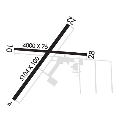 Airport Diagram might not be current. | |
| Facility Name: | ST CLAIR COUNTY INTL |
| City Name: | PORT HURON |
| County: | ST CLAIR |
| State abbrev: | MI |
| State Name: | MICHIGAN |
| Ownership: | PUBLICLY OWNED |
| Use: | OPEN TO THE PUBLIC |
| Owner's Name: | SAINT CLAIR COUNTY |
| Address: | 201 MCMORRAN BLVD |
| PORT HURON, MI 48060-4006 | |
| Owner's Phone: | 810-364-6890 |
| Manager's Name: | CATHERINE FIORE |
| Address: | 177 ASH DR |
| KIMBALL, MI 48074-4403 | |
| Phone: | 810-364-6890 |
| FAA Region: | GREAT LAKES |
| FAA Field Office: | DET |

| Date | Sunrise | Sunset |
|---|---|---|
| 06/07/26 Sunday | 5:52 | 21:06 |
| 06/08/26 Monday | 5:51 | 21:07 |
| 06/09/26 Tuesday | 5:51 | 21:08 |
| 06/10/26 Wednesday | 5:51 | 21:08 |
| 06/11/26 Thursday | 5:51 | 21:09 |
| 06/12/26 Friday | 5:51 | 21:09 |
| 06/13/26 Saturday | 5:51 | 21:10 |
| 06/14/26 Sunday | 5:51 | 21:10 |
| 06/15/26 Monday | 5:51 | 21:11 |
| 06/16/26 Tuesday | 5:51 | 21:11 |
| 06/17/26 Wednesday | 5:51 | 21:11 |
| 06/18/26 Thursday | 5:51 | 21:12 |
| 06/19/26 Friday | 5:51 | 21:12 |
| 06/20/26 Saturday | 5:51 | 21:12 |
| Airport Attendance Schedule | 7 Days A Week 0800-1700; UNATNDD MAJOR HOLS. |
| Airport Status | OPERATIONAL (This Status can change at any time - please check NOTAMS) |
| Airport Lighting Schedule | ACTVT MALSR RWY 04; REIL RWY 22, 10, & 28; PAPI RWY 10 & 28; HIRL RWY 04/22; MIRL RWY 10/28 - CTAF. PAPI RWY 04 & 22 OPR CONSLY. |
| Airport Storage Available | Tie Downs, Hanger |
| Extra Services Available | NONE |
| Wind Indicator | YES - (lighted) |
| Control Tower | NO |
| CTAF Frequency | 123.050 |
| Unicom Frequency | 123.050 |
| Rotating Beacon Color | WG |
| Segmented Circle | YES |
| Landing Fee | YES; COML & CORPORATE LDG FEE WAIVED WITH FUEL PURCHASE. |
| Airport Inspected | STATE - performed by STATE AERONAUTICAL PERSONNEL |
| Inspection Date | 05/08/2025 |
| Type of Fuel Available | Grade 100LL, JET A |
| Airframe Repair Service | MAJOR |
| Power Plant Repair Service | MAJOR |
| Latitude | N4254.7 |
| Longitude | W08231.7 (ESTIMATED) |
| Arpt Elevation | 650ft (SURVEYED) |
| Magnetic Variation | 07W |
| 5 miles SW | of PORT HURON |
| Traffic Pattern Altitude | |
| Sectional Chart | DETROIT |
| Operations (Reported) | Yearly | Avg. Daily |
|---|---|---|
| General Aviation Transient | 0 | 0 |
| General Aviation Local | 0 | 0 |
| Air Taxi | 0 | 0 |
| Commerical | 0 | 0 |
| Commuter | 0 | 0 |
| Military | 0 | 0 |
| Aircraft based on Field | |
|---|---|
| General Aviation Singles | 0 |
| General Aviation Multi | 0 |
| Jet Aircraft | 0 |
| General Aviation Helicopters | 0 |
| Military Aircraft | 0 |
| Gliders | 0 |
| Ultralights | 0 |
| FSS on field | NO |
| FSS tie-in | LANSING |
| FSS Phone | 1-800-WX-BRIEF |
| Who issues Notams | PHN |
| Notam D service at airport | YES |
| ARTCC Name | CLEVELAND |
| Airport Certification | |
| Aircraft Rescue & Firefighting Index | None |
| Airport of Entry | YES |
| Custom Landing Rights | No |
| Joint Civil/Military | No |
| Military Landing rights | YES |
| NATIONAL PLAN OF INTEGRATED AIRPORT SYSTEMS (NPIAS) |
| GRANT AGREEMENTS UNDER FAAP/ADAP/AIP |
| ASSURANCES PURSUANT TO TITLE VI, CIVIL RIGHTS ACT OF 1964 |
| DEER & LRG BIRDS ON & INVOF ARPT. |
| TSATLC FLTS MUST NTFY US CUST AT 810-985-9541 ONE HR PRIOR TO ENTRY INTO THE US. NTFY US DEPT OF AGRICULTURE AT 810-985-6126 & AMGR 24 HRS PRIOR FOR DISPOSAL OF ACFT INTL TRASH. |
| FOR CD CTC SELFRIDGE APCH AT 586-239-5706, WHEN APCH CLSD CTC CLEVELAND ARTCC AT 440-774-0224/0490. |
Airport Communications & Frequencies:
| |||||||||||||||||
| Runway: 04 | Runway: 22 | ||
| Mag heading: | 43° | Mag heading: | 223° |
| Rwy Slope: | .19% Up | Rwy Slope: | -.19% Down |
| Approach: | ILS | Approach: | |
| Pattern: | Left Traffic | Pattern: | Left Traffic |
| Markings: | PRECISION INSTRUMENT | Markings: | PRECISION INSTRUMENT |
| Marking Condition: | GOOD | Marking Condition: | GOOD |
| Arresting Dev: | Arresting Dev: | ||
| Lat & Long: | N4254.3 W08232.1 | Lat. & Long.: | N4255.0 W08231.4 |
| Elev: | 639.8 ft. MSL | Elev: | 649.5 ft. MSL |
| TCH: | 50 ft. AGL | TCH: | 45 ft. AGL |
| Visual Glide Path: | 3.00 degrees | Visual Glide Path: | 3.00 degrees |
| Displaced Threshold: | No | Displaced Threshold: | No |
| Touchdown Zone: | YES | Touchdown Zone: | YES |
| Touchdown Elev.: | 647.2 feet | Touchdown Elev.: | 649.5 feet |
| Visual Glide Slope: | 4-Light PAPI on LEFT side of Runway | Visual Glide Slope: | 4-Light PAPI on LEFT side of Runway |
| RVR Equipment: | RVR Equipment: | ||
| RVV Equipment: | NO | RVV Equipment: | NO |
| Approach Lights: | MALSR - 1,400 foot medium intensity approach lighting system with runway alignment indicator lights | Approach Lights: | |
| REIL: | NO | REIL: | YES |
| Centerline Lights: | NO | Centerline Lights: | NO |
| Touchdown lights: | NO | Touchdown lights: | NO |
| Runway Category: | Precision Instrument Runway | Runway Category: | Runway with a Non-precision Approach having visibility minimums greater than 3/4 mile |
| Declared Distances: | Declared Distances: | ||
| Obstructions: | TREE | Obstructions: | TREE |
| Marked: | NOT Marked/Lighted | Marked: | NOT Marked/Lighted |
| Clearance slope: | 8:1 | Clearance slope: | 21:1 |
| Obstruction height: | 49 feet AGL | Obstruction height: | 76 feet AGL |
| Dist. from runway: | 592 feet | Dist. from runway: | 1870 feet |
| Centerline offset: | 573 left of centerline | Centerline offset: | 78 feet right of centerline |
| Comments: | Comments: |
| Runway: 10 | Runway: 28 | ||
| Mag heading: | 102° | Mag heading: | 282° |
| Rwy Slope: | .18% Up | Rwy Slope: | -.18% Down |
| Approach: | Approach: | ||
| Pattern: | Left Traffic | Pattern: | Left Traffic |
| Markings: | NONPRECISION INSTRUMENT | Markings: | NONPRECISION INSTRUMENT |
| Marking Condition: | FAIR | Marking Condition: | FAIR |
| Arresting Dev: | Arresting Dev: | ||
| Lat & Long: | N4254.7 W08232.1 | Lat. & Long.: | N4254.7 W08231.2 |
| Elev: | 643.1 ft. MSL | Elev: | 650.1 ft. MSL |
| TCH: | 26 ft. AGL | TCH: | 33 ft. AGL |
| Visual Glide Path: | 3.00 degrees | Visual Glide Path: | 3.50 degrees |
| Displaced Threshold: | No | Displaced Threshold: | No |
| Touchdown Zone: | YES | Touchdown Zone: | YES |
| Touchdown Elev.: | 647.3 feet | Touchdown Elev.: | 650.1 feet |
| Visual Glide Slope: | 4-Light PAPI on LEFT side of Runway | Visual Glide Slope: | 4-Light PAPI on LEFT side of Runway |
| RVR Equipment: | RVR Equipment: | ||
| RVV Equipment: | NO | RVV Equipment: | NO |
| Approach Lights: | Approach Lights: | ||
| REIL: | YES | REIL: | YES |
| Centerline Lights: | NO | Centerline Lights: | NO |
| Touchdown lights: | NO | Touchdown lights: | NO |
| Runway Category: | Runway with a Non-precision Approach | Runway Category: | Runway with a Non-precision Approach |
| Declared Distances: | Declared Distances: | ||
| Obstructions: | TREE | Obstructions: | TREE |
| Marked: | NOT Marked/Lighted | Marked: | NOT Marked/Lighted |
| Clearance slope: | 16:1 | Clearance slope: | 17:1 |
| Obstruction height: | 71 feet AGL | Obstruction height: | 57 feet AGL |
| Dist. from runway: | 1386 feet | Dist. from runway: | 1173 feet |
| Centerline offset: | 250 left of centerline | Centerline offset: | 35 feet right of centerline |
| Comments: | Comments: |
Thanks for using FltPlan.com
all rights reserved © 1999-2026 by Flight Plan LLC