| KIRK FIELD PARAGOULD AR |
| |
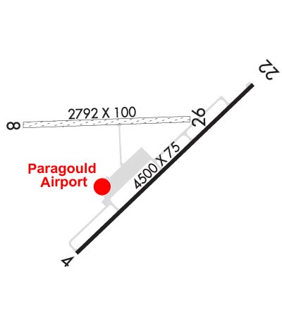
| Lat: N 3603.8 Long: W 09030.6 Elev: 290 Var: -01 Longest Runway: 4500 | ||
| CTAF: 122.8 | ||
| ||||||||||||||||||||||||||||||||||||||||||||||||||||||||||||||||||||
| ||||||||||||||||||||||||||||||||||||||||||||||||||||||||||||||||||||
| Rwy | Rwy | |||||||
| 4500x75 | 4011' | 4500x75 | 4352' | |||||
| 2792x100 | 2792' | 2792x100 | 2792' | |||||
| Runway ID | Single Wheel | Double Wheel | Double Tandem Wheel | Dual Double Wheel |
| 04/22 | 12,500 | N/A | N/A | N/A |
| 08/26 | N/A | N/A | N/A | N/A |
| These numbers are Advisory and are not limits. The Airport Manager should have more accurate Weight Limits | ||||
 Airport Diagram might not be current. | |
| Facility Name: | KIRK FLD |
| City Name: | PARAGOULD |
| County: | GREENE |
| State abbrev: | AR |
| State Name: | ARKANSAS |
| Ownership: | PUBLICLY OWNED |
| Use: | OPEN TO THE PUBLIC |
| Owner's Name: | CITY OF PARAGOULD |
| Address: | 301 WEST COURT |
| PARAGOULD, AR 72450 | |
| Owner's Phone: | 870-239-7510 |
| Manager's Name: | ROGER SLAYTON |
| Address: | 305 AIRPORT ROAD |
| PARAGOULD, AR 72450 | |
| Phone: | 870-239-7505 |
| FAA Region: | SOUTHWEST |
| FAA Field Office: | AOK |
| Date | Sunrise | Sunset |
|---|---|---|
| 06/08/26 Monday | 5:45 | 20:17 |
| 06/09/26 Tuesday | 5:45 | 20:18 |
| 06/10/26 Wednesday | 5:45 | 20:18 |
| 06/11/26 Thursday | 5:45 | 20:19 |
| 06/12/26 Friday | 5:44 | 20:19 |
| 06/13/26 Saturday | 5:44 | 20:20 |
| 06/14/26 Sunday | 5:44 | 20:20 |
| 06/15/26 Monday | 5:45 | 20:20 |
| 06/16/26 Tuesday | 5:45 | 20:21 |
| 06/17/26 Wednesday | 5:45 | 20:21 |
| 06/18/26 Thursday | 5:45 | 20:21 |
| 06/19/26 Friday | 5:45 | 20:22 |
| 06/20/26 Saturday | 5:45 | 20:22 |
| 06/21/26 Sunday | 5:45 | 20:22 |
| Airport Attendance Schedule | MON-FRI 0700-1600; FOR SVC AFT HRS CALL 870-450-7599 FEE CHARGED. |
| Airport Status | OPERATIONAL (This Status can change at any time - please check NOTAMS) |
| Airport Lighting Schedule | ACTVT MIRL RY 04/22, REIL & PAPI RYS 04 & 22 - CTAF. |
| Airport Storage Available | Tie Downs |
| Extra Services Available | Air Ambulance, Flight Instruction |
| Wind Indicator | YES - (lighted) |
| Control Tower | NO |
| CTAF Frequency | 122.800 |
| Unicom Frequency | 122.800 |
| Rotating Beacon Color | WG |
| Segmented Circle | YES |
| Landing Fee | NO |
| Airport Inspected | STATE - performed by STATE AERONAUTICAL PERSONNEL |
| Inspection Date | 07/12/2023 |
| Type of Fuel Available | Grade 100LL, JET A (freeze point -40C); -1024 HR SELF SVC FUEL AVBL WITH CREDIT CARD (100LL & JET A) |
| Airframe Repair Service | None |
| Power Plant Repair Service | None |
| Latitude | N3603.8 |
| Longitude | W09030.6 (ESTIMATED) |
| Arpt Elevation | 290ft (SURVEYED) |
| Magnetic Variation | 01E |
| 1 miles NW | of PARAGOULD |
| Traffic Pattern Altitude | 809 |
| Sectional Chart | ST LOUIS |
| Operations (Reported) | Yearly | Avg. Daily |
|---|---|---|
| General Aviation Transient | 0 | 0 |
| General Aviation Local | 0 | 0 |
| Air Taxi | 0 | 0 |
| Commerical | 0 | 0 |
| Commuter | 0 | 0 |
| Military | 0 | 0 |
| Aircraft based on Field | |
|---|---|
| General Aviation Singles | 0 |
| General Aviation Multi | 0 |
| Jet Aircraft | 0 |
| General Aviation Helicopters | 0 |
| Military Aircraft | 0 |
| Gliders | 0 |
| Ultralights | 0 |
| FSS on field | NO |
| FSS tie-in | JONESBORO |
| FSS Phone | 1-800-WX-BRIEF |
| Who issues Notams | JBR |
| Notam D service at airport | YES |
| ARTCC Name | MEMPHIS |
| Airport Certification | |
| Aircraft Rescue & Firefighting Index | None |
| Airport of Entry | No |
| Custom Landing Rights | No |
| Joint Civil/Military | No |
| Military Landing rights | YES |
| NATIONAL PLAN OF INTEGRATED AIRPORT SYSTEMS (NPIAS) |
| GRANT AGREEMENTS UNDER FAAP/ADAP/AIP |
| ASSURANCES PURSUANT TO TITLE VI, CIVIL RIGHTS ACT OF 1964 |
| THIS AIRPORT HAS BEEN SURVEYED BY THE NATIONAL GEODETIC SURVEY. |
| UNLGTD TOWER 250 FT AGL .17 MILES ESE AER 04. |
| WILDLIFE ON & INVOF OF RY AND TWY. |
| FOR CD CTC MEMPHIS ARTCC AT 901-368-8453/8449. |
| RWY 08/2 6 SOFT WHEN WET. |
Airport Communications & Frequencies:
| |||||||||
| Runway: 04 | Runway: 22 | ||
| Mag heading: | 45° | Mag heading: | 225° |
| Rwy Slope: | -.10% Down | Rwy Slope: | .10% Up |
| Approach: | Approach: | ||
| Pattern: | Left Traffic | Pattern: | Left Traffic |
| Markings: | NONPRECISION INSTRUMENT | Markings: | NONPRECISION INSTRUMENT |
| Marking Condition: | FAIR | Marking Condition: | FAIR |
| Arresting Dev: | Arresting Dev: | ||
| Lat & Long: | N3603.5 W09030.8 | Lat. & Long.: | N3604.0 W09030.1 |
| Elev: | 289.6 ft. MSL | Elev: | 285.0 ft. MSL |
| TCH: | 18 ft. AGL | TCH: | 59 ft. AGL |
| Visual Glide Path: | 3.00 degrees | Visual Glide Path: | 4.00 degrees |
| Displaced Threshold: | 489 feet | Displaced Threshold: | 148 feet |
| Touchdown Zone: | YES | Touchdown Zone: | YES |
| Touchdown Elev.: | 290.2 feet | Touchdown Elev.: | 289.3 feet |
| Visual Glide Slope: | 2-Light PAPI on LEFT side of Runway | Visual Glide Slope: | 2-Light PAPI on LEFT side of Runway |
| RVR Equipment: | RVR Equipment: | ||
| RVV Equipment: | NO | RVV Equipment: | NO |
| Approach Lights: | Approach Lights: | ||
| REIL: | YES | REIL: | YES |
| Centerline Lights: | NO | Centerline Lights: | NO |
| Touchdown lights: | NO | Touchdown lights: | NO |
| Runway Category: | Runway with a Non-precision Approach having visibility minimums greater than 3/4 mile | Runway Category: | Runway with a Non-precision Approach having visibility minimums greater than 3/4 mile |
| Declared Distances: | Declared Distances: | ||
| Obstructions: | ROAD | Obstructions: | ROAD |
| Marked: | NOT Marked/Lighted | Marked: | NOT Marked/Lighted |
| Clearance slope: | APCH RATIO 23:1 TO DSPLCD THLD. | Clearance slope: | 20:1; APCH SLOPE 46:1 TO DSPLD THLD. |
| Obstruction height: | 28 feet AGL | Obstruction height: | 13 feet AGL |
| Dist. from runway: | 180 feet | Dist. from runway: | 460 feet |
| Centerline offset: | Centerline offset: | 200 feet left of centerline | |
| Comments: | ROAD 180 FT & EXTENDS INTO RY PROTECTION ZONE. | Comments: | OPEN DITCH 55 FT WIDE; 10 FT DEEP 138 FT FM THLD CROSSING. |
| Runway: 08 | Runway: 26 | ||
| Mag heading: | 88° | Mag heading: | 268° |
| Rwy Slope: | -.14% Down | Rwy Slope: | .14% Up |
| Approach: | Approach: | ||
| Pattern: | Left Traffic | Pattern: | Left Traffic |
| Markings: | NONSTANDARD | Markings: | NONSTANDARD |
| Marking Condition: | GOOD | Marking Condition: | GOOD |
| Arresting Dev: | Arresting Dev: | ||
| Lat & Long: | N3603.9 W09031.0 | Lat. & Long.: | N3603.9 W09030.4 |
| Elev: | 283.0 ft. MSL | Elev: | 279.0 ft. MSL |
| TCH: | TCH: | ||
| Visual Glide Path: | Visual Glide Path: | ||
| Displaced Threshold: | No | Displaced Threshold: | No |
| Touchdown Zone: | YES | Touchdown Zone: | YES |
| Touchdown Elev.: | 283.0 feet | Touchdown Elev.: | 279.0 feet |
| Visual Glide Slope: | Visual Glide Slope: | ||
| RVR Equipment: | RVR Equipment: | ||
| RVV Equipment: | NO | RVV Equipment: | NO |
| Approach Lights: | Approach Lights: | ||
| REIL: | NO | REIL: | NO |
| Centerline Lights: | NO | Centerline Lights: | NO |
| Touchdown lights: | NO | Touchdown lights: | NO |
| Runway Category: | Runway with a Visual Approach | Runway Category: | Runway with a Visual Approach |
| Declared Distances: | Declared Distances: | ||
| Obstructions: | PLINE | Obstructions: | TREES |
| Marked: | NOT Marked/Lighted | Marked: | NOT Marked/Lighted |
| Clearance slope: | 32:1 | Clearance slope: | 43:1 |
| Obstruction height: | 40 feet AGL | Obstruction height: | 40 feet AGL |
| Dist. from runway: | 1300 feet | Dist. from runway: | 1750 feet |
| Centerline offset: | 50 right of centerline | Centerline offset: | |
| Comments: | Comments: |
Thanks for using FltPlan.com
all rights reserved © 1999-2026 by Flight Plan LLC