
| WAUPACA MUNI WAUPACA WI |
| |
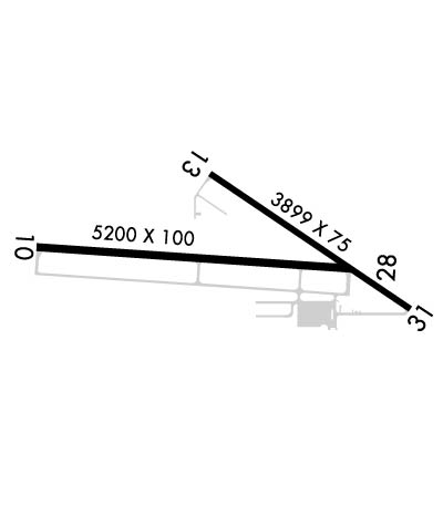
| Lat: N 4420.0 Long: W 08901.2 Elev: 840 Var: +01 Longest Runway: 5200 | ||
| AWOS: 118.62 CTAF: 122.8 | ||
| ||||||
| ||||||
|
| Rwy | Rwy | |||||||
| 5200x100 | 5200' | 5200x100 | 5200' | |||||
| 3899x75 | 3899' | 3899x75 | 3899' | |||||
| Runway ID | Single Wheel | Double Wheel | Double Tandem Wheel | Dual Double Wheel |
| 10/28 | N/A | N/A | N/A | N/A |
| 13/31 | 13,000 | N/A | N/A | N/A |
| These numbers are Advisory and are not limits. The Airport Manager should have more accurate Weight Limits | ||||
 Airport Diagram might not be current. | |
| Facility Name: | WAUPACA MUNI |
| City Name: | WAUPACA |
| County: | WAUPACA |
| State abbrev: | WI |
| State Name: | WISCONSIN |
| Ownership: | PUBLICLY OWNED |
| Use: | OPEN TO THE PUBLIC |
| Owner's Name: | CITY OF WAUPACA |
| Address: | CITY HALL |
| WAUPACA, WI 54981 | |
| Owner's Phone: | 715-258-4411 |
| Manager's Name: | MATHEW KLATT |
| Address: | 2601 RUNWAY DRIVE |
| WAUPACA, WI 54981 | |
| Phone: | 715-258-4427; AFT HRS CALL 920-225-9881. |
| FAA Region: | GREAT LAKES |
| FAA Field Office: | CHI |
| Date | Sunrise | Sunset |
|---|---|---|
| 06/08/26 Monday | 5:12 | 20:38 |
| 06/09/26 Tuesday | 5:12 | 20:39 |
| 06/10/26 Wednesday | 5:12 | 20:39 |
| 06/11/26 Thursday | 5:12 | 20:40 |
| 06/12/26 Friday | 5:11 | 20:40 |
| 06/13/26 Saturday | 5:11 | 20:41 |
| 06/14/26 Sunday | 5:11 | 20:41 |
| 06/15/26 Monday | 5:11 | 20:42 |
| 06/16/26 Tuesday | 5:11 | 20:42 |
| 06/17/26 Wednesday | 5:11 | 20:43 |
| 06/18/26 Thursday | 5:11 | 20:43 |
| 06/19/26 Friday | 5:12 | 20:43 |
| 06/20/26 Saturday | 5:12 | 20:44 |
| 06/21/26 Sunday | 5:12 | 20:44 |
| Airport Attendance Schedule | MON-FRI 0800-1700, SEP - MAY 7 Days A Week 0800-1700; OPEN MEMORIAL DAY TO LABOR DAY. |
| Airport Status | OPERATIONAL (This Status can change at any time - please check NOTAMS) |
| Airport Lighting Schedule | ACTVT REIL RWY 10 & 28; MIRL RWY 13/31 - CTAF. MIRL RWY 10/28 PRESET TO LOW SS-SR; TO INCR INTST & ACTVT - CTAF. |
| Airport Storage Available | Tie Downs, Hanger |
| Extra Services Available | Air Ambulance, Flight Instruction, Aircraft Rental |
| Wind Indicator | YES - (lighted) |
| Control Tower | NO |
| CTAF Frequency | 122.800 |
| Unicom Frequency | 122.800 |
| Rotating Beacon Color | WG |
| Segmented Circle | YES |
| Landing Fee | NO |
| Airport Inspected | STATE - performed by STATE AERONAUTICAL PERSONNEL |
| Inspection Date | 06/12/2025 |
| Type of Fuel Available | Grade 100LL, JET A; -1024 HR FUEL AVBL WITH CREDIT CARD. |
| Airframe Repair Service | MAJOR |
| Power Plant Repair Service | MAJOR |
| Latitude | N4420.0 |
| Longitude | W08901.2 (ESTIMATED) |
| Arpt Elevation | 840ft (SURVEYED) |
| Magnetic Variation | 01W |
| 3 miles SE | of WAUPACA |
| Traffic Pattern Altitude | |
| Sectional Chart | GREEN BAY |
| Operations (Reported) | Yearly | Avg. Daily |
|---|---|---|
| General Aviation Transient | 0 | 0 |
| General Aviation Local | 0 | 0 |
| Air Taxi | 0 | 0 |
| Commerical | 0 | 0 |
| Commuter | 0 | 0 |
| Military | 0 | 0 |
| Aircraft based on Field | |
|---|---|
| General Aviation Singles | 0 |
| General Aviation Multi | 0 |
| Jet Aircraft | 0 |
| General Aviation Helicopters | 0 |
| Military Aircraft | 0 |
| Gliders | 0 |
| Ultralights | 0 |
| FSS on field | NO |
| FSS tie-in | GREEN BAY |
| FSS Phone | 1-800-WX-BRIEF |
| Who issues Notams | PCZ |
| Notam D service at airport | YES |
| ARTCC Name | MINNEAPOLIS |
| Airport Certification | |
| Aircraft Rescue & Firefighting Index | None |
| Airport of Entry | No |
| Custom Landing Rights | No |
| Joint Civil/Military | No |
| Military Landing rights | YES |
| NATIONAL PLAN OF INTEGRATED AIRPORT SYSTEMS (NPIAS) |
| GRANT AGREEMENTS UNDER FAAP/ADAP/AIP |
| ASSURANCES PURSUANT TO TITLE VI, CIVIL RIGHTS ACT OF 1964 |
| TWY LGTS AT ENTRANCE ONLY. |
| FOR CD CTC MINNEAPOLIS ARTCC AT 651-463-5588. |
| RWY 13/3 1 NMRS CRACKS AND VEGETATION IN PAVEMENT. |
Airport Communications & Frequencies:
| |||||||||||||
| Runway: 10 | Runway: 28 | ||
| Mag heading: | 94° | Mag heading: | 274° |
| Rwy Slope: | -.67% Down | Rwy Slope: | .67% Up |
| Approach: | Approach: | ||
| Pattern: | Left Traffic | Pattern: | Left Traffic |
| Markings: | NONPRECISION INSTRUMENT | Markings: | NONPRECISION INSTRUMENT |
| Marking Condition: | FAIR | Marking Condition: | FAIR |
| Arresting Dev: | Arresting Dev: | ||
| Lat & Long: | N4420.0 W08902.0 | Lat. & Long.: | N4420.0 W08900.8 |
| Elev: | 840.0 ft. MSL | Elev: | 805.2 ft. MSL |
| TCH: | 40 ft. AGL | TCH: | 40 ft. AGL |
| Visual Glide Path: | 3.00 degrees | Visual Glide Path: | 3.00 degrees |
| Displaced Threshold: | No | Displaced Threshold: | No |
| Touchdown Zone: | YES | Touchdown Zone: | YES |
| Touchdown Elev.: | 840.2 feet | Touchdown Elev.: | 826.9 feet |
| Visual Glide Slope: | 2-Light PAPI on LEFT side of Runway; PAPI ON CONTINUOUSLY. | Visual Glide Slope: | 2-Light PAPI on LEFT side of Runway; PAPI ON CONTINUOUSLY. |
| RVR Equipment: | RVR Equipment: | ||
| RVV Equipment: | NO | RVV Equipment: | NO |
| Approach Lights: | Approach Lights: | ||
| REIL: | YES | REIL: | YES |
| Centerline Lights: | NO | Centerline Lights: | NO |
| Touchdown lights: | NO | Touchdown lights: | NO |
| Runway Category: | Runway with a Non-precision Approach having visibility minimums greater than 3/4 mile | Runway Category: | Runway with a Non-precision Approach having visibility minimums greater than 3/4 mile |
| Declared Distances: | Declared Distances: | ||
| Obstructions: | Obstructions: | TREES | |
| Marked: | Marked: | NOT Marked/Lighted | |
| Clearance slope: | 34:1 | Clearance slope: | 22:1 |
| Obstruction height: | Obstruction height: | 59 feet AGL | |
| Dist. from runway: | Dist. from runway: | 1500 feet | |
| Centerline offset: | Centerline offset: | 350 feet right of centerline | |
| Comments: | Comments: |
| Runway: 13 | Runway: 31 | ||
| Mag heading: | 124° | Mag heading: | 304° |
| Rwy Slope: | -.61% Down | Rwy Slope: | .61% Up |
| Approach: | Approach: | ||
| Pattern: | Left Traffic | Pattern: | Left Traffic |
| Markings: | NONPRECISION INSTRUMENT | Markings: | NONPRECISION INSTRUMENT |
| Marking Condition: | POOR; MRKGS FADED. | Marking Condition: | POOR; MRKGS FADED. |
| Arresting Dev: | Arresting Dev: | ||
| Lat & Long: | N4420.2 W08901.3 | Lat. & Long.: | N4419.8 W08900.6 |
| Elev: | 826.6 ft. MSL | Elev: | 802.8 ft. MSL |
| TCH: | 43 ft. AGL | TCH: | 38 ft. AGL |
| Visual Glide Path: | 4.00 degrees | Visual Glide Path: | 3.00 degrees |
| Displaced Threshold: | No | Displaced Threshold: | No |
| Touchdown Zone: | YES | Touchdown Zone: | YES |
| Touchdown Elev.: | 826.6 feet | Touchdown Elev.: | 818.7 feet |
| Visual Glide Slope: | 4-Light PAPI on LEFT side of Runway; PAPI ON CONTINUOUSLY. | Visual Glide Slope: | 2-Light PAPI on LEFT side of Runway; PAPI ON CONTINUOUSLY. |
| RVR Equipment: | RVR Equipment: | ||
| RVV Equipment: | NO | RVV Equipment: | NO |
| Approach Lights: | Approach Lights: | ||
| REIL: | NO | REIL: | NO |
| Centerline Lights: | NO | Centerline Lights: | NO |
| Touchdown lights: | NO | Touchdown lights: | NO |
| Runway Category: | Runway with a Visual Approach | Runway Category: | Runway with a Visual Approach |
| Declared Distances: | Declared Distances: | ||
| Obstructions: | TREES | Obstructions: | |
| Marked: | NOT Marked/Lighted | Marked: | |
| Clearance slope: | 15:1 | Clearance slope: | 20:1 |
| Obstruction height: | 75 feet AGL | Obstruction height: | |
| Dist. from runway: | 1330 feet | Dist. from runway: | |
| Centerline offset: | 210 right of centerline | Centerline offset: | |
| Comments: | Comments: |
Thanks for using FltPlan.com
all rights reserved © 1999-2026 by Flight Plan LLC
