| CARL R KELLER FIELD PORT CLINTON OH |
| |
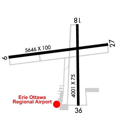
| Lat: N 4131.0 Long: W 08252.2 Elev: 590 Var: +07 Longest Runway: 5646 | ||
| AWOS: 118.77 CTAF: 122.8 | ||
| |||||||||||||||||||||||
| |||||||||||||||||||||||
| |||||||||||||||||||||||
| Rwy | Rwy | |||||||
| 5646x100 | 5646' | 5646x100 | 5445' | |||||
| 4002x75 | 4002' | 4002x75 | 4002' | |||||
| Runway ID | Single Wheel | Double Wheel | Double Tandem Wheel | Dual Double Wheel |
| 09/27 | 100,000 | N/A | N/A | N/A |
| 18/36 | N/A | N/A | N/A | N/A |
| These numbers are Advisory and are not limits. The Airport Manager should have more accurate Weight Limits | ||||
 Airport Diagram might not be current. | |
| Facility Name: | ERIE-OTTAWA INTL |
| City Name: | PORT CLINTON |
| County: | OTTAWA |
| State abbrev: | OH |
| State Name: | OHIO |
| Ownership: | PUBLICLY OWNED |
| Use: | OPEN TO THE PUBLIC |
| Owner's Name: | ERIE OTTAWA ARPT AUTH |
| Address: | 3255 E STATE RD |
| PORT CLINTON, OH 43452-2542 | |
| Owner's Phone: | 419-734-6297 |
| Manager's Name: | STAN GEBHARDT |
| Address: | 3255 E STATE RD |
| PORT CLINTON, OH 43452-2542 | |
| Phone: | 419-734-6297 |
| FAA Region: | GREAT LAKES |
| FAA Field Office: | DET |
| Date | Sunrise | Sunset |
|---|---|---|
| 09/24/21 Friday | 7:21 | 19:26 |
| 09/25/21 Saturday | 7:22 | 19:24 |
| 09/26/21 Sunday | 7:23 | 19:22 |
| 09/27/21 Monday | 7:24 | 19:20 |
| 09/28/21 Tuesday | 7:25 | 19:19 |
| 09/29/21 Wednesday | 7:26 | 19:17 |
| 09/30/21 Thursday | 7:27 | 19:15 |
| 10/01/21 Friday | 7:28 | 19:14 |
| 10/02/21 Saturday | 7:29 | 19:12 |
| 10/03/21 Sunday | 7:30 | 19:10 |
| 10/04/21 Monday | 7:31 | 19:09 |
| 10/05/21 Tuesday | 7:32 | 19:07 |
| 10/06/21 Wednesday | 7:33 | 19:05 |
| 10/07/21 Thursday | 7:34 | 19:04 |
| Airport Attendance Schedule | 7 Days A Week 0700-1700 |
| Airport Status | OPERATIONAL (This Status can change at any time - please check NOTAMS) |
| Airport Lighting Schedule | ACTVT REIL RWY 09 & 27; HIRL RWY 09/27; MIRL RWY 18/36 - CTAF. PAPI RWY 09 & 27 OPR CONSLY. |
| Airport Storage Available | Tie Downs, Hanger |
| Extra Services Available | Charter, Flight Instruction, Parachute Jumping, Aircraft Rental, Aircraft Sales |
| Wind Indicator | YES - (lighted) |
| Control Tower | NO |
| CTAF Frequency | 122.800 |
| Unicom Frequency | 122.800 |
| Rotating Beacon Color | CLEAR-GREEN (Light Land Airport) |
| Segmented Circle | NO |
| Landing Fee | NO |
| Airport Inspected | STATE - performed by STATE AERONAUTICAL PERSONNEL |
| Inspection Date | 10/16/2020 |
| Type of Fuel Available | Grade 100LL, JET A |
| Airframe Repair Service | MAJOR |
| Power Plant Repair Service | MAJOR |
| Latitude | N4131.0 |
| Longitude | W08252.2 (ESTIMATED) |
| Arpt Elevation | 590ft (SURVEYED) |
| Magnetic Variation | 07W |
| 3 miles E | of PORT CLINTON |
| Traffic Pattern Altitude | |
| Sectional Chart | DETROIT |
| Operations (Reported) | Yearly | Avg. Daily |
|---|---|---|
| General Aviation Transient | 15000 | 41 |
| General Aviation Local | 25000 | 68 |
| Air Taxi | 14000 | 38 |
| Commerical | 0 | 0 |
| Commuter | 0 | 0 |
| Military | 150 | 0 |
| Aircraft based on Field | |
|---|---|
| General Aviation Singles | 61 |
| General Aviation Multi | 9 |
| Jet Aircraft | 6 |
| General Aviation Helicopters | 1 |
| Military Aircraft | 0 |
| Gliders | 0 |
| Ultralights | 0 |
| FSS on field | NO |
| FSS tie-in | CLEVELAND |
| FSS Phone | 1-800-WX-BRIEF |
| Who issues Notams | CLE |
| Notam D service at airport | YES |
| ARTCC Name | CLEVELAND |
| Airport Certification | |
| Aircraft Rescue & Firefighting Index | None |
| Airport of Entry | No |
| Custom Landing Rights | YES |
| Joint Civil/Military | No |
| Military Landing rights | YES |
| NATIONAL PLAN OF INTEGRATED AIRPORT SYSTEMS (NPIAS) |
| GRANT AGREEMENTS UNDER FAAP/ADAP/AIP |
| ASSURANCES PURSUANT TO TITLE VI, CIVIL RIGHTS ACT OF 1964 |
| RWY 09/27 IS PREFERRED WHEN WINDS ARE LIGHT AND VRBL. |
| TXL A CLSD TO ACFT WITH WINGSPAN GTR THAN 49 FT. |
| BIRDS & OTR WILDLIFE ON & INVOF ARPT. |
| FOR CD CTC CLEVELAND APCH AT 216-352-2323. |
| CUST AVBL 24 HRS 7 DAYS PER WEEK. REQ MUST BE MADE PRIOR TO ARR. LCL OFC 419-732-4446. |
Airport Communications & Frequencies:
| ||||||||||||||
| Runway: 09 | Runway: 27 | ||
| Mag heading: | 90° | Mag heading: | 270° |
| Rwy Slope: | -.01% Down | Rwy Slope: | .01% Up |
| Approach: | Approach: | ||
| Pattern: | Left Traffic | Pattern: | Left Traffic |
| Markings: | NONPRECISION INSTRUMENT | Markings: | NONPRECISION INSTRUMENT |
| Marking Condition: | GOOD | Marking Condition: | GOOD |
| Arresting Dev: | Arresting Dev: | ||
| Lat & Long: | N4131.0 W08252.9 | Lat. & Long.: | N4131.1 W08251.7 |
| Elev: | 588.7 ft. MSL | Elev: | 588.2 ft. MSL |
| TCH: | 40 ft. AGL | TCH: | 40 ft. AGL |
| Visual Glide Path: | 3.00 degrees | Visual Glide Path: | 3.00 degrees |
| Displaced Threshold: | No | Displaced Threshold: | 201 feet |
| Touchdown Zone: | YES | Touchdown Zone: | YES |
| Touchdown Elev.: | 590.1 feet | Touchdown Elev.: | 588.4 feet |
| Visual Glide Slope: | 4-Light PAPI on LEFT side of Runway | Visual Glide Slope: | 4-Light PAPI on LEFT side of Runway |
| RVR Equipment: | RVR Equipment: | ||
| RVV Equipment: | NO | RVV Equipment: | NO |
| Approach Lights: | Approach Lights: | ||
| REIL: | YES | REIL: | YES |
| Centerline Lights: | NO | Centerline Lights: | NO |
| Touchdown lights: | NO | Touchdown lights: | NO |
| Runway Category: | Runway with a Non-precision Approach having visibility minimums greater than 3/4 mile | Runway Category: | Runway with a Non-precision Approach having visibility minimums greater than 3/4 mile |
| Declared Distances: | TORA:5646' TODA:5646' ASDA:5161' LDA:5161' | Declared Distances: | TORA:5646' TODA:5646' ASDA:5646' LDA:5445' |
| Obstructions: | TREE | Obstructions: | TREE |
| Marked: | NOT Marked/Lighted | Marked: | NOT Marked/Lighted |
| Clearance slope: | 22:1 | Clearance slope: | 21:1 |
| Obstruction height: | 65 feet AGL | Obstruction height: | 42 feet AGL |
| Dist. from runway: | 1659 feet | Dist. from runway: | 1098 feet |
| Centerline offset: | 402 right of centerline | Centerline offset: | 334 feet right of centerline |
| Comments: | Comments: |
| Runway: 18 | Runway: 36 | ||
| Mag heading: | 185° | Mag heading: | 5° |
| Rwy Slope: | .07% Up | Rwy Slope: | -.07% Down |
| Approach: | Approach: | ||
| Pattern: | Left Traffic | Pattern: | Left Traffic |
| Markings: | BASIC | Markings: | BASIC |
| Marking Condition: | FAIR | Marking Condition: | FAIR |
| Arresting Dev: | Arresting Dev: | ||
| Lat & Long: | N4131.2 W08252.0 | Lat. & Long.: | N4130.6 W08252.0 |
| Elev: | 586.1 ft. MSL | Elev: | 589.0 ft. MSL |
| TCH: | TCH: | ||
| Visual Glide Path: | Visual Glide Path: | ||
| Displaced Threshold: | No | Displaced Threshold: | No |
| Touchdown Zone: | YES | Touchdown Zone: | YES |
| Touchdown Elev.: | 588.5 feet | Touchdown Elev.: | 589.3 feet |
| Visual Glide Slope: | Visual Glide Slope: | ||
| RVR Equipment: | RVR Equipment: | ||
| RVV Equipment: | NO | RVV Equipment: | NO |
| Approach Lights: | Approach Lights: | ||
| REIL: | NO | REIL: | NO |
| Centerline Lights: | NO | Centerline Lights: | NO |
| Touchdown lights: | NO | Touchdown lights: | NO |
| Runway Category: | Runway with a Visual Approach | Runway Category: | Runway with a Visual Approach |
| Declared Distances: | Declared Distances: |
Thanks for using FltPlan.com
all rights reserved © 1999-2021 by Flight Plan LLC