
| PALM BEACH INTL WEST PALM BEACH FL |
| |
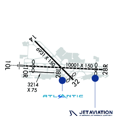
| Lat: N 2641.0 Long: W 08005.7 Elev: 20 Var: +06 Longest Runway: 10001 | ||
| Clr Del: 121.6 Dept. ATIS: 123.75 Arr. ATIS: 123.75 Ground: 121.9 Tower: 119.1 | ||

| |||||||||||||||||||||||||||||||||||||||||||||||||||||||||||||||||||||
| |||||||||||||||||||||||||||||||||||||||||||||||||||||||||||||||||||||
| |||||||||||||||||||||||||||||||||||||||||||||||||||||||||||||||||||||
| |||||||||||||||||||||||||||||||||||||||||||||||||||||||||||||||||||||
| |||||||||||||||||||||||||||||||||||||||||||||||||||||||||||||||||||||
| |||||||||||||||||||||||||||||||||||||||||||||||||||||||||||||||||||||
| |||||||||||||||||||||||||||||||||||||||||||||||||||||||||||||||||||||
| FBOs at nearby airports who want your business: | |||||||||||||||||
| |||||||||||||||||
| |||||||||||||||||
| Rwy | Rwy | |||||||
| 10001x150 | 8801' | 111.90 - 098° | 10001x150 | 9190' | 111.90 - 278° | |||
| 3214x75 | 3214' | 3214x75 | 3214' | |||||
| 6931x150 | 6931' | 6931x150 | 6513' | |||||
| Runway ID | Single Wheel | Double Wheel | Double Tandem Wheel | Dual Double Wheel |
| 10L/28R | 120,000 | 250,000 | 550,000 | 1,073,000 |
| 10R/28L | 25,000 | N/A | N/A | N/A |
| 14/32 | 120,000 | 250,000 | 521,000 | 1,042,000 |
| These numbers are Advisory and are not limits. The Airport Manager should have more accurate Weight Limits | ||||
 Airport Diagram might not be current. | |
| Facility Name: | PALM BEACH INTL |
| City Name: | WEST PALM BEACH |
| County: | PALM BEACH |
| State abbrev: | FL |
| State Name: | FLORIDA |
| Ownership: | PUBLICLY OWNED |
| Use: | OPEN TO THE PUBLIC |
| Owner's Name: | PALM BEACH COUNTY |
| Address: | 846 PALM BEACH INTL AIRPORT |
| WEST PALM BEACH, FL 33406 | |
| Owner's Phone: | 561-471-7420 |
| Manager's Name: | LAURA BEEBE |
| Address: | 846 PALM BEACH INTL AIRPORT |
| WEST PALM BEACH, FL 33406 | |
| Phone: | 561-471-7420 |
| FAA Region: | SOUTHERN |
| FAA Field Office: | ORL |
| Date | Sunrise | Sunset |
|---|---|---|
| 06/08/26 Monday | 6:26 | 20:13 |
| 06/09/26 Tuesday | 6:26 | 20:13 |
| 06/10/26 Wednesday | 6:26 | 20:13 |
| 06/11/26 Thursday | 6:26 | 20:14 |
| 06/12/26 Friday | 6:26 | 20:14 |
| 06/13/26 Saturday | 6:26 | 20:14 |
| 06/14/26 Sunday | 6:26 | 20:15 |
| 06/15/26 Monday | 6:27 | 20:15 |
| 06/16/26 Tuesday | 6:27 | 20:15 |
| 06/17/26 Wednesday | 6:27 | 20:16 |
| 06/18/26 Thursday | 6:27 | 20:16 |
| 06/19/26 Friday | 6:27 | 20:16 |
| 06/20/26 Saturday | 6:27 | 20:16 |
| 06/21/26 Sunday | 6:28 | 20:17 |
| Airport Attendance Schedule | CONTINUOUS |
| Airport Status | OPERATIONAL (This Status can change at any time - please check NOTAMS) |
| Airport Lighting Schedule | SS-SR |
| Airport Storage Available | Tie Downs |
| Extra Services Available | Air Freight, Air Ambulance, Avionics, Cargo Handling, Charter, Flight Instruction, Aircraft Rental, Aircraft Sales, Annual Surveying |
| Wind Indicator | YES - (unlit) |
| Control Tower | YES |
| CTAF Frequency | |
| Unicom Frequency | 122.950 |
| Rotating Beacon Color | WG |
| Segmented Circle | NO |
| Landing Fee | NO |
| Airport Inspected | FEDERAL - performed by FAA AIRPORTS FIELD PERSONNEL |
| Inspection Date | 05/30/2025 |
| Type of Fuel Available | Grade 100LL, JET A (freeze point -40C) |
| Airframe Repair Service | MAJOR |
| Power Plant Repair Service | MAJOR |
| Latitude | N2641.0 |
| Longitude | W08005.7 (ESTIMATED) |
| Arpt Elevation | 19ft (SURVEYED) |
| Magnetic Variation | 06W |
| 3 miles W | of WEST PALM BEACH |
| Traffic Pattern Altitude | |
| Sectional Chart | MIAMI |
| Operations (Reported) | Yearly | Avg. Daily |
|---|---|---|
| General Aviation Transient | 0 | 0 |
| General Aviation Local | 0 | 0 |
| Air Taxi | 0 | 0 |
| Commerical | 0 | 0 |
| Commuter | 0 | 0 |
| Military | 0 | 0 |
| Aircraft based on Field | |
|---|---|
| General Aviation Singles | 0 |
| General Aviation Multi | 0 |
| Jet Aircraft | 0 |
| General Aviation Helicopters | 0 |
| Military Aircraft | 0 |
| Gliders | 0 |
| Ultralights | 0 |
| FSS on field | NO |
| FSS tie-in | MIAMI |
| FSS Phone | 1-800-WX-BRIEF |
| Who issues Notams | PBI |
| Notam D service at airport | YES |
| ARTCC Name | MIAMI |
| Airport Certification | AIRPORT RECEIVING SCHEDULED AIR CARRIER SERVICE FROM CARRIERS CERTIFICATED BY THE CIVIL AERONAUTICS BOARD; INDEX D ARFF EQUIPMENT AVAILABLE; 24 HOUR PPR. |
| Aircraft Rescue & Firefighting Index | AIRPORT HAS A CERTIFICATE UNDER CFR PART 139 |
| Airport of Entry | YES |
| Custom Landing Rights | No |
| Joint Civil/Military | No |
| Military Landing rights | YES |
| NATIONAL PLAN OF INTEGRATED AIRPORT SYSTEMS (NPIAS) |
| GRANT AGREEMENTS UNDER FAAP/ADAP/AIP |
| SURPLUS PROPERTY AGREEMENT UNDER PUBLIC LAW 289 |
| ASSURANCES PURSUANT TO TITLE VI, CIVIL RIGHTS ACT OF 1964 |
| MIGRATORY BIRDS ON AND INVOF ARPT. |
| BE ALERT: TWY L IS LCTD BTWN RYS 10L/28R & 10R/28L. TWY L IS WIDER AND LONGER THAN RY 10R/28L - DO NOT CONFUSE TWY L FOR RY. AIRCRAFT WITH WINGSPAN OF 118 FT OR GREATER IS PROHIBITED ON TWY L. |
| 24 HR PPR FOR ACFT WITH WINGSPANS GTR THAN 171 FT. |
| ACFT WITH WINGSPANS GTR THAN 118 FT MAY NOT OPR ON TWY E, TWY W, TWY Y AND TWY F NW OF TWY A. |
| RWY 14/32 SAFETY AREA NOT STD SFC VARNS. |
| RWY 10L/28R SAFETY AREA NOT STD SFC VARNS. |
| ACFT WITH WINGSPANS GTR THAN 49 MAY NOT OPER SIMUL ON RWY 10R/28L AND TWY R. |
| RWY 10L/28R SAFETY AREA NOT STD SFC VARNS. |
| RWY 14 LAHSO SIGNAGE NOT STD. |
| NOISE ABATEMENT PROCEDURES IN EFFECT. MULTIENGINE FLIGHT TRAINING PROHIBITED SS TO SR SUN AND HOLIDAY; STRICT ENVIRONMENTAL OPERATING STAGE 2 ACFT 0300-1200Z CALL NOISE ABATEMENT OFFICER 561-471-7467. |
| 24 HR ADVN NOTICE OR IMT REPORTING UPON LDG FOR ACFT EQUIPPED WITH WEATHER MODIFICATION OR GEOENGINEERING EQUIP CTC ARPT OPS 561-471-7420. |
| BE ALERT; RYS 28L & 28R THLDS STAGGERED BY 5400 FT. |
| RWY 10R/ 28LRWY 10R/28L NOT AVBL FOR PART 121/PART 380 OPS WITH SKED PAX CARRYING OPS MORE THAN 9 PAX SEATS AND NON-SKED PAX CARRYING OPS MORE THAN 30 PAX SEATS. |
| RWY 14/3 2 ARRESTING GEAR/SYSTEM: ENGINEERED MATERIALS ARRESTING SYSTEM (EMAS) 222 FT IN LENGTH BY 170 FT IN WIDTH AT THE DEPARTURE END OF RWY 14. |
| RWY 10L/ 28RPCR VALUE: 710/F/B/W/T |
| RWY 10R/ 28LPCR VALUE: 260/F/A/X/T |
| RWY 14/3 2 PCR VALUE: 610/F/A/W/T |
Airport Communications & Frequencies:
| |||||||||||||||||||||||||||||||||||||||||||||||||||||
| Runway: 10L | Runway: 28R | ||
| Mag heading: | 99° | Mag heading: | 279° |
| Rwy Slope: | -.03% Down | Rwy Slope: | .03% Up |
| Approach: | ILS/DME | Approach: | LOC/GS |
| Pattern: | Left Traffic | Pattern: | Left Traffic |
| Markings: | PRECISION INSTRUMENT | Markings: | PRECISION INSTRUMENT |
| Marking Condition: | GOOD | Marking Condition: | GOOD |
| Arresting Dev: | Arresting Dev: | ||
| Lat & Long: | N2641.0 W08006.5 | Lat. & Long.: | N2640.9 W08004.7 |
| Elev: | 19.6 ft. MSL | Elev: | 16.4 ft. MSL |
| TCH: | 68 ft. AGL | TCH: | 70 ft. AGL |
| Visual Glide Path: | 3.00 degrees | Visual Glide Path: | 3.00 degrees |
| Displaced Threshold: | 1200 feet | Displaced Threshold: | 811 feet |
| Touchdown Zone: | YES | Touchdown Zone: | YES |
| Touchdown Elev.: | 16.3 feet | Touchdown Elev.: | 18.3 feet |
| Visual Glide Slope: | 4-Light PAPI on RIGHT side of Runway | Visual Glide Slope: | 4-Light PAPI on LEFT side of Runway |
| RVR Equipment: | TOUCHDOWN-ROLLOUT | RVR Equipment: | TOUCHDOWN-ROLLOUT |
| RVV Equipment: | NO | RVV Equipment: | NO |
| Approach Lights: | MALSR - 1,400 foot medium intensity approach lighting system with runway alignment indicator lights | Approach Lights: | |
| REIL: | NO | REIL: | YES |
| Centerline Lights: | YES | Centerline Lights: | YES |
| Touchdown lights: | NO | Touchdown lights: | NO |
| Runway Category: | Precision Instrument Runway | Runway Category: | Precision Instrument Runway |
| Declared Distances: | TORA:10001' TODA:10001' ASDA:9351' LDA:8151' | Declared Distances: | TORA:10001' TODA:10001' ASDA:9051' LDA:8240' |
| Obstructions: | TREES | Obstructions: | TREES |
| Marked: | NOT Marked/Lighted | Marked: | NOT Marked/Lighted |
| Clearance slope: | 35:1; RWY 10L & RWY 28R APCH RATIO 50:1 AT DISPLACEMENT. | Clearance slope: | 50:1 |
| Obstruction height: | 41 feet AGL | Obstruction height: | 40 feet AGL |
| Dist. from runway: | 1665 feet | Dist. from runway: | 2230 feet |
| Centerline offset: | 515 left of centerline | Centerline offset: | 670 feet left of centerline |
| Comments: | Comments: |
| Runway: 10R | Runway: 28L | ||
| Mag heading: | 99° | Mag heading: | 279° |
| Rwy Slope: | -.11% Down | Rwy Slope: | .11% Up |
| Approach: | Approach: | ||
| Pattern: | Right Traffic | Pattern: | Left Traffic |
| Markings: | BASIC | Markings: | BASIC |
| Marking Condition: | GOOD | Marking Condition: | GOOD |
| Arresting Dev: | Arresting Dev: | ||
| Lat & Long: | N2640.9 W08006.4 | Lat. & Long.: | N2640.8 W08005.8 |
| Elev: | 17.1 ft. MSL | Elev: | 13.6 ft. MSL |
| TCH: | TCH: | ||
| Visual Glide Path: | Visual Glide Path: | ||
| Displaced Threshold: | No | Displaced Threshold: | No |
| Touchdown Zone: | YES | Touchdown Zone: | YES |
| Touchdown Elev.: | 17.2 feet | Touchdown Elev.: | 16.9 feet |
| Visual Glide Slope: | Visual Glide Slope: | ||
| RVR Equipment: | RVR Equipment: | ||
| RVV Equipment: | NO | RVV Equipment: | NO |
| Approach Lights: | Approach Lights: | ||
| REIL: | YES | REIL: | YES |
| Centerline Lights: | NO | Centerline Lights: | NO |
| Touchdown lights: | NO | Touchdown lights: | NO |
| Runway Category: | Runway with a Visual Approach | Runway Category: | Runway with a Visual Approach |
| Declared Distances: | TORA:3214' TODA:3214' ASDA:3214' LDA:3214' | Declared Distances: | TORA:3214' TODA:3214' ASDA:3214' LDA:3214' |
| Obstructions: | TREES | Obstructions: | |
| Marked: | NOT Marked/Lighted | Marked: | |
| Clearance slope: | 40:1 | Clearance slope: | 20:1 |
| Obstruction height: | 30 feet AGL | Obstruction height: | |
| Dist. from runway: | 1416 feet | Dist. from runway: | |
| Centerline offset: | 205 right of centerline | Centerline offset: | |
| Comments: | Comments: |
| Runway: 14 | Runway: 32 | ||
| Mag heading: | 141° | Mag heading: | 321° |
| Rwy Slope: | -.02% Down | Rwy Slope: | .02% Up |
| Approach: | Approach: | ||
| Pattern: | Left Traffic | Pattern: | Left Traffic |
| Markings: | NONPRECISION INSTRUMENT | Markings: | NONPRECISION INSTRUMENT |
| Marking Condition: | GOOD | Marking Condition: | GOOD |
| Arresting Dev: | EMAS | Arresting Dev: | |
| Lat & Long: | N2641.5 W08006.2 | Lat. & Long.: | N2640.7 W08005.3 |
| Elev: | 17.0 ft. MSL | Elev: | 15.8 ft. MSL |
| TCH: | 66 ft. AGL | TCH: | 57 ft. AGL |
| Visual Glide Path: | 3.00 degrees | Visual Glide Path: | 3.25 degrees |
| Displaced Threshold: | No | Displaced Threshold: | 418 feet |
| Touchdown Zone: | YES | Touchdown Zone: | YES |
| Touchdown Elev.: | 17.3 feet | Touchdown Elev.: | 15.9 feet |
| Visual Glide Slope: | 4-Light PAPI on RIGHT side of Runway | Visual Glide Slope: | 4-Light PAPI on LEFT side of Runway |
| RVR Equipment: | RVR Equipment: | ||
| RVV Equipment: | NO | RVV Equipment: | NO |
| Approach Lights: | Approach Lights: | ||
| REIL: | YES | REIL: | YES |
| Centerline Lights: | NO | Centerline Lights: | NO |
| Touchdown lights: | NO | Touchdown lights: | NO |
| Runway Category: | D | Runway Category: | D |
| Declared Distances: | TORA:6926' TODA:6926' ASDA:6000' LDA:6000' | Declared Distances: | TORA:6926' TODA:6926' ASDA:6926' LDA:6513' |
| Obstructions: | TREES | Obstructions: | ROAD |
| Marked: | NOT Marked/Lighted | Marked: | NOT Marked/Lighted |
| Clearance slope: | 34:1 | Clearance slope: | APCH RATIO 36:1 FM DSPLCD THR; TREES 965 FT OUT & 385 FT L. |
| Obstruction height: | 34 feet AGL | Obstruction height: | 17 feet AGL |
| Dist. from runway: | 1370 feet | Dist. from runway: | 200 feet |
| Centerline offset: | 230 right of centerline | Centerline offset: | 250 feet left of centerline |
| Comments: | Comments: | ROAD 200 FT FM AER RWY 32, 250 FT LEFT OF CNTRLN. |
Thanks for using FltPlan.com
all rights reserved © 1999-2026 by Flight Plan LLC