
| JUNEAU INTL JUNEAU AK |
| |
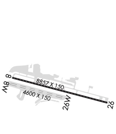
| Lat: N 5821.3 Long: W 13434.7 Elev: 25 Var: -20 Longest Runway: 8857 | ||
| Clr Del: 121.9 Dept. ATIS: 135.2 Arr. ATIS: 135.2 Ground: 121.9 Tower: 118.7 | ||
| ||||||||||||||||||||||||||||||
| ||||||||||||||||||||||||||||||
| ||||||||||||||||||||||||||||||
| ||||||||||||||||||||||||||||||
| ||||||||||||||||||||||||||||||
| ||||||||||||||||||||||||||||||
| Rwy | Rwy | |||||||
| 8857x150 | 8857' | 109.90 - 070° | 8857x150 | 8857' | ||||
| 4800x150 | 4800' | 4800x150 | 4800' | |||||
| Runway ID | Single Wheel | Double Wheel | Double Tandem Wheel | Dual Double Wheel |
| 08/26 | 120,000 | 250,000 | 550,000 | N/A |
| 08W/26W | N/A | N/A | N/A | N/A |
| These numbers are Advisory and are not limits. The Airport Manager should have more accurate Weight Limits | ||||
 Airport Diagram might not be current. | |
| Facility Name: | JUNEAU INTL |
| City Name: | JUNEAU |
| County: | JUNEAU |
| State abbrev: | AK |
| State Name: | ALASKA |
| Ownership: | PUBLICLY OWNED |
| Use: | OPEN TO THE PUBLIC |
| Owner's Name: | CITY OF JUNEAU |
| Address: | 155 S SEWARD |
| JUNEAU, AK 99801 | |
| Owner's Phone: | 907-789-7821 |
| Manager's Name: | ANDRES DELGADO |
| Address: | 1873 SHELL SIMMONS DR, SUITE 200 |
| JUNEAU, AK 99801 | |
| Phone: | 907-789-7821 |
| FAA Region: | ALASKA |
| FAA Field Office: | NONE |
| Date | Sunrise | Sunset |
|---|---|---|
| 06/08/26 Monday | 3:55 | 22:00 |
| 06/09/26 Tuesday | 3:54 | 22:01 |
| 06/10/26 Wednesday | 3:54 | 22:02 |
| 06/11/26 Thursday | 3:53 | 22:03 |
| 06/12/26 Friday | 3:52 | 22:04 |
| 06/13/26 Saturday | 3:52 | 22:05 |
| 06/14/26 Sunday | 3:52 | 22:06 |
| 06/15/26 Monday | 3:51 | 22:06 |
| 06/16/26 Tuesday | 3:51 | 22:07 |
| 06/17/26 Wednesday | 3:51 | 22:08 |
| 06/18/26 Thursday | 3:51 | 22:08 |
| 06/19/26 Friday | 3:51 | 22:08 |
| 06/20/26 Saturday | 3:51 | 22:09 |
| 06/21/26 Sunday | 3:51 | 22:09 |
| Airport Attendance Schedule | CONTINUOUS |
| Airport Status | OPERATIONAL (This Status can change at any time - please check NOTAMS) |
| Airport Lighting Schedule | WHEN ATCT CLSD ACTVT MALSF RWY 08; REIL RWY 26; HIRL RWY 08/26 - CTAF. VASI RWY 08; PAPI RWY 26 OPR CONSLY. |
| Airport Storage Available | Tie Downs, Hanger, Buoys |
| Extra Services Available | Air Freight, Air Ambulance, Avionics, Cargo Handling, Charter, Flight Instruction |
| Wind Indicator | YES - (lighted) |
| Control Tower | YES |
| CTAF Frequency | 118.700 |
| Unicom Frequency | 122.950 |
| Rotating Beacon Color | WG |
| Segmented Circle | YES |
| Landing Fee | YES |
| Airport Inspected | FEDERAL - performed by FAA AIRPORTS FIELD PERSONNEL |
| Inspection Date | 11/20/2025 |
| Type of Fuel Available | Grade 100LL, JET A-1 (icing inhibitor, freeze point -50C) |
| Airframe Repair Service | MAJOR; SINGLE/TWIN PROP ENG; TURBIN & AVIONICS. |
| Power Plant Repair Service | MAJOR |
| Latitude | N5821.3 |
| Longitude | W13434.7 (ESTIMATED) |
| Arpt Elevation | 25ft (ESTIMATED) |
| Magnetic Variation | 20E |
| 7 miles NW | of JUNEAU |
| Traffic Pattern Altitude | |
| Sectional Chart | JUNEAU |
| Operations (Reported) | Yearly | Avg. Daily |
|---|---|---|
| General Aviation Transient | 0 | 0 |
| General Aviation Local | 0 | 0 |
| Air Taxi | 0 | 0 |
| Commerical | 0 | 0 |
| Commuter | 0 | 0 |
| Military | 0 | 0 |
| Aircraft based on Field | |
|---|---|
| General Aviation Singles | 0 |
| General Aviation Multi | 0 |
| Jet Aircraft | 0 |
| General Aviation Helicopters | 0 |
| Military Aircraft | 0 |
| Gliders | 0 |
| Ultralights | 0 |
| FSS on field | YES |
| FSS tie-in | JUNEAU; WHEN ATCT CLSD ARPT ADZY SVC - CTAF. |
| FSS Phone | 1-800-866-297-2236 |
| Who issues Notams | JNU |
| Notam D service at airport | YES |
| ARTCC Name | ANCHORAGE |
| Airport Certification | AIRPORT RECEIVING SCHEDULED AIR CARRIER SERVICE FROM CARRIERS CERTIFICATED BY THE CIVIL AERONAUTICS BOARD |
| Aircraft Rescue & Firefighting Index | AIRPORT HAS A CERTIFICATE UNDER CFR PART 139 |
| Airport of Entry | YES |
| Custom Landing Rights | No |
| Joint Civil/Military | No |
| Military Landing rights | YES |
| NATIONAL PLAN OF INTEGRATED AIRPORT SYSTEMS (NPIAS) |
| GRANT AGREEMENTS UNDER FAAP/ADAP/AIP |
| SURPLUS PROPERTY AGREEMENT UNDER PUBLIC LAW 289 |
| CONVEYANCE UNDER SCETION 16, FEDERAL AIRPORT ACT OF 1946 OR SECTION 23, AIRPORT AND AIRWAY DEVELOPMENT ACT OF 1970 |
| ASSURANCES PURSUANT TO TITLE VI, CIVIL RIGHTS ACT OF 1964 |
| JUNEAU FSS - LCL 907-789-7380. |
| TSNT PUB DOCK SW CORNER. |
| SEE SPL NOTICES & GENOT FOR INFO ON OPS IN JUNEAU AREA. |
| LENA POINT, PEDERSON HILL & SISTERS IS WX CAMERAS AVBL ON INTERNET AT HTTPS://WEATHERCAMS.FAA.GOV |
| COLD TEMPERATURE AIRPORT. ALTITUDE CORRECTION REQUIRED AT OR BELOW 1C. |
| APRON TERM RAMP CLSD TO ROTORCRAFT. CUST RAMP APRON CLSD TO WINGSPAN GTR THAN 79 FT. INTL ROTORCRAFT USE E-1 NG RAMP. |
| FUEL SVC - UNICOM OR 907-789-0055/5622. |
| NG 24 HR PPR - C907-789-3366. WKDAY 0730-1600 CTC NG OPS 10 MIN BFR LNDG - 124.65. |
| WILDLIFE & BIRDS ON & INVOF ARPT. |
| BATTLESHIP IS RLLS GROUPING; CNTR LGT 582132.88N 1344012.22W. JDL LOC RLLS GROUPING; CNTR LGT 582132.02N 1343810.39W. |
| HVY HEL & ACFT ACT APR 15-OCT 1; FULL LEN GASTINEAU CHNL & WI 5 MI. |
| PARAGLIDING ACT 3 MI N; INVOF THUNDER MOUNTAIN & OVR GASTINEAU CHNL NEARS DOWNTOWN APR 15-OCT 1; 6000 FT & BLW. |
| TPA 1500 AGL FOR LARGE TURBINE ACFT; 1000 FT AGL FOR FIXED WING ACFT; 500 FT AGL FOR HELICOPTERS. |
| RWY 08/2 6 SAND USED FOR FRICTION MAY NOT MEET FAA SPECS. |
| RWY 08/2 6 PCR VALUE: 892/F/A/X/T |
Airport Communications & Frequencies:
| |||||||||||||||||||||
| Runway: 08 | Runway: 26 | ||
| Mag heading: | 85° | Mag heading: | 265° |
| Rwy Slope: | -.02% Down | Rwy Slope: | .02% Up |
| Approach: | LDA/DME | Approach: | |
| Pattern: | Right Traffic | Pattern: | Left Traffic |
| Markings: | NONPRECISION INSTRUMENT | Markings: | NONPRECISION INSTRUMENT |
| Marking Condition: | FAIR | Marking Condition: | FAIR |
| Arresting Dev: | Arresting Dev: | ||
| Lat & Long: | N5821.5 W13435.8 | Lat. & Long.: | N5821.1 W13433.1 |
| Elev: | 25.0 ft. MSL | Elev: | 23.4 ft. MSL |
| TCH: | 38 ft. AGL | TCH: | 46 ft. AGL |
| Visual Glide Path: | 3.50 degrees | Visual Glide Path: | 3.50 degrees |
| Displaced Threshold: | No | Displaced Threshold: | No |
| Touchdown Zone: | YES | Touchdown Zone: | YES |
| Touchdown Elev.: | 25.0 feet | Touchdown Elev.: | 23.4 feet |
| Visual Glide Slope: | 2-Box VASI on LEFT side of Runway; VASI UNUSBL BYD 06 DEGS LEFT OF CNTRLN. VASI ALIGNED 13 DEG R OF CNTRLN; NOT VIS ON CNTRLN. | Visual Glide Slope: | 4-Light PAPI on LEFT side of Runway; RWY 26 PAPI UNUSBL BYD 2 NM DUE TO TRRN. |
| RVR Equipment: | TOUCHDOWN-ROLLOUT | RVR Equipment: | TOUCHDOWN-ROLLOUT |
| RVV Equipment: | YES | RVV Equipment: | YES |
| Approach Lights: | MALSF - 1,400 foot medium intensity approach lighting system with sequenced flashers; RLLS LGT: JNUB BATTLESHIP ISLAND, JNUA ENGINEERS CUT, JNU WETLANDS/FLATS. | Approach Lights: | MALS - 1,400 foot medium intensity approach lighting system; NSTD; LEN 800 FT. |
| REIL: | NO | REIL: | YES |
| Centerline Lights: | YES | Centerline Lights: | YES |
| Touchdown lights: | NO | Touchdown lights: | NO |
| Runway Category: | Runway with a Non-precision Approach having visibility minimums greater than 3/4 mile | Runway Category: | Runway with a Non-precision Approach having visibility minimums greater than 3/4 mile |
| Declared Distances: | TORA:8857' TODA:8857' ASDA:8457' LDA:8457' | Declared Distances: | TORA:8857' TODA:8857' ASDA:8457' LDA:8457' |
| Obstructions: | TOWER | Obstructions: | |
| Marked: | MARKED and LIGHTED | Marked: | |
| Clearance slope: | 12:1 | Clearance slope: | 34:1 |
| Obstruction height: | 573 feet AGL | Obstruction height: | |
| Dist. from runway: | 7600 feet | Dist. from runway: | |
| Centerline offset: | 900 left of centerline | Centerline offset: | |
| Comments: | Comments: |
| Runway: 08W | Runway: 26W | ||
| Mag heading: | N/A | Mag heading: | N/A |
| Approach: | Approach: | ||
| Pattern: | Left Traffic | Pattern: | Left Traffic |
| Markings: | Markings: | ||
| Marking Condition: | Marking Condition: | ||
| Arresting Dev: | Arresting Dev: | ||
| Lat & Long: | N5821.4 W13435.9 | Lat. & Long.: | N5821.2 W13434.4 |
| Elev: | N/A | Elev: | N/A |
| TCH: | TCH: | ||
| Visual Glide Path: | Visual Glide Path: | ||
| Displaced Threshold: | No | Displaced Threshold: | No |
| Touchdown Zone: | NO | Touchdown Zone: | NO |
| Touchdown Elev.: | Touchdown Elev.: | ||
| Visual Glide Slope: | Visual Glide Slope: | ||
| RVR Equipment: | RVR Equipment: | ||
| RVV Equipment: | NO | RVV Equipment: | NO |
| Approach Lights: | Approach Lights: | ||
| REIL: | NO | REIL: | NO |
| Centerline Lights: | NO | Centerline Lights: | NO |
| Touchdown lights: | NO | Touchdown lights: | NO |
| Runway Category: | Runway with a Visual Approach | Runway Category: | Runway with a Visual Approach |
| Declared Distances: | Declared Distances: |
Thanks for using FltPlan.com
all rights reserved © 1999-2026 by Flight Plan LLC


