
| BARKLEY RGNL PADUCAH KY |
| |
| Lat: N 3703.6 Long: W 08846.4 Elev: 411 Var: +01 Longest Runway: 6500 | ||
| AWOS: 118.37 Ground: 121.7 Tower: 119.6 | ||
| |||||||||||||||||||||||||||||||||||||||||||||||||||||||||||||
| |||||||||||||||||||||||||||||||||||||||||||||||||||||||||||||
| |||||||||||||||||||||||||||||||||||||||||||||||||||||||||||||
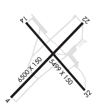
| Rwy | Rwy | |||||||
| 6500x150 | 6500' | 108.50 - 043° | 6500x150 | 6500' | ||||
| 5499x150 | 5399' | 5499x150 | 5499' | |||||
| Runway ID | Single Wheel | Double Wheel | Double Tandem Wheel | Dual Double Wheel |
| 05/23 | 76,000 | 99,000 | 170,000 | N/A |
| 14/32 | 75,000 | 100,000 | 170,000 | N/A |
| These numbers are Advisory and are not limits. The Airport Manager should have more accurate Weight Limits | ||||
 Airport Diagram might not be current. | |
| Facility Name: | BARKLEY RGNL |
| City Name: | PADUCAH |
| County: | MC CRACKEN |
| State abbrev: | KY |
| State Name: | KENTUCKY |
| Ownership: | PUBLICLY OWNED |
| Use: | OPEN TO THE PUBLIC |
| Owner's Name: | BARKLEY REGIONAL AIRPORT AUTHORITY |
| Address: | 2901 FISHER RD, PO BOX 38 |
| WEST PADUCAH, KY 42086-1131 | |
| Owner's Phone: | 270-744-0521 |
| Manager's Name: | DENNIS G. ROULEAU |
| Address: | 2901 FISHER RD, PO BOX 38 |
| WEST PADUCAH, KY 42086-1131 | |
| Phone: | 270-744-0521 |
| FAA Region: | SOUTHERN |
| FAA Field Office: | MEM |
| Date | Sunrise | Sunset |
|---|---|---|
| 09/24/21 Friday | 6:44 | 18:49 |
| 09/25/21 Saturday | 6:45 | 18:48 |
| 09/26/21 Sunday | 6:46 | 18:46 |
| 09/27/21 Monday | 6:47 | 18:45 |
| 09/28/21 Tuesday | 6:48 | 18:43 |
| 09/29/21 Wednesday | 6:49 | 18:42 |
| 09/30/21 Thursday | 6:49 | 18:40 |
| 10/01/21 Friday | 6:50 | 18:39 |
| 10/02/21 Saturday | 6:51 | 18:37 |
| 10/03/21 Sunday | 6:52 | 18:36 |
| 10/04/21 Monday | 6:53 | 18:34 |
| 10/05/21 Tuesday | 6:54 | 18:33 |
| 10/06/21 Wednesday | 6:55 | 18:31 |
| 10/07/21 Thursday | 6:55 | 18:30 |
| Airport Attendance Schedule | 7 Days A Week 0500-1800 |
| Airport Status | OPERATIONAL (This Status can change at any time - please check NOTAMS) |
| Airport Lighting Schedule | WHEN ATCT CLSD ACTVT MALSR RWY 05; REIL RWY 23 & 32; PAPI RWY 23 &32; HIRL RWY 05/23; MIRL RWY 14/32; TWY LGTS; LGTD WIND CONE - CTAF. |
| Airport Storage Available | Tie Downs, Hanger |
| Extra Services Available | Avionics |
| Wind Indicator | YES - (lighted) |
| Control Tower | YES |
| CTAF Frequency | 119.600 |
| Unicom Frequency | 122.950 |
| Rotating Beacon Color | CLEAR-GREEN (Light Land Airport) |
| Segmented Circle | YES |
| Landing Fee | NO |
| Airport Inspected | FEDERAL - performed by FAA AIRPORTS FIELD PERSONNEL |
| Inspection Date | 06/05/2019 |
| Type of Fuel Available | Grade 100LL, JET A (freeze point -40C) |
| Airframe Repair Service | MAJOR |
| Power Plant Repair Service | MAJOR |
| Latitude | N3703.6 |
| Longitude | W08846.4 (ESTIMATED) |
| Arpt Elevation | 410ft (SURVEYED) |
| Magnetic Variation | 01W |
| 12 miles W | of PADUCAH |
| Traffic Pattern Altitude | |
| Sectional Chart | ST LOUIS |
| Operations (Reported) | Yearly | Avg. Daily |
|---|---|---|
| General Aviation Transient | 12781 | 35 |
| General Aviation Local | 5998 | 16 |
| Air Taxi | 1854 | 5 |
| Commerical | 1386 | 4 |
| Commuter | 0 | 0 |
| Military | 1518 | 4 |
| Aircraft based on Field | |
|---|---|
| General Aviation Singles | 30 |
| General Aviation Multi | 4 |
| Jet Aircraft | 6 |
| General Aviation Helicopters | 0 |
| Military Aircraft | 0 |
| Gliders | 0 |
| Ultralights | 0 |
| FSS on field | NO |
| FSS tie-in | LOUISVILLE |
| FSS Phone | 1-800-WX-BRIEF |
| Who issues Notams | PAH |
| Notam D service at airport | YES |
| ARTCC Name | MEMPHIS |
| Airport Certification | AIRPORT RECEIVING SCHEDULED AIR CARRIER SERVICE FROM CARRIERS CERTIFICATED BY THE CIVIL AERONAUTICS BOARD; ACR OPS WITH MORE THAN 30 PAX SEATS 24 HR PPR - 270-744-0521. |
| Aircraft Rescue & Firefighting Index | AIRPORT HAS A CERTIFICATE UNDER CFR PART 139 |
| Airport of Entry | No |
| Custom Landing Rights | No |
| Joint Civil/Military | No |
| Military Landing rights | YES |
| NATIONAL PLAN OF INTEGRATED AIRPORT SYSTEMS (NPIAS) |
| GRANT AGREEMENTS UNDER FAAP/ADAP/AIP |
| ASSURANCES PURSUANT TO TITLE VI, CIVIL RIGHTS ACT OF 1964 |
| AGREEMENT UNDER DLAND OR DCLA HAS EXPIRED. |
| NWS ON ARPT - 270-744-6440. |
| SFC COND NOT MNTD 0001-0500; WET SFC COND NOT RPRTD. |
| FOR CD CTC MEMPHIS ARTCC AT 901-368-8453/8449. |
| RWY 05/2 3 ACFT OPS NOT VSB FM OPPOSITE RWY ENDS DUE TO GRADE. |
Airport Communications & Frequencies:
| |||||||||||||||||
| Runway: 05 | Runway: 23 | ||
| Mag heading: | 45° | Mag heading: | 225° |
| Rwy Slope: | -.45% Down | Rwy Slope: | .45% Up |
| Approach: | ILS | Approach: | |
| Pattern: | Left Traffic | Pattern: | Left Traffic |
| Markings: | PRECISION INSTRUMENT | Markings: | PRECISION INSTRUMENT |
| Marking Condition: | GOOD | Marking Condition: | GOOD |
| Arresting Dev: | Arresting Dev: | ||
| Lat & Long: | N3703.2 W08846.9 | Lat. & Long.: | N3704.0 W08846.0 |
| Elev: | 410.6 ft. MSL | Elev: | 381.4 ft. MSL |
| TCH: | TCH: | 50 ft. AGL | |
| Visual Glide Path: | Visual Glide Path: | 3.00 degrees | |
| Displaced Threshold: | No | Displaced Threshold: | No |
| Touchdown Zone: | YES | Touchdown Zone: | YES |
| Touchdown Elev.: | 410.9 feet | Touchdown Elev.: | 402.4 feet |
| Visual Glide Slope: | Visual Glide Slope: | 4-Light PAPI on LEFT side of Runway | |
| RVR Equipment: | RVR Equipment: | ||
| RVV Equipment: | NO | RVV Equipment: | NO |
| Approach Lights: | MALSR - 1,400 foot medium intensity approach lighting system with runway alignment indicator lights | Approach Lights: | |
| REIL: | NO | REIL: | YES |
| Centerline Lights: | NO | Centerline Lights: | NO |
| Touchdown lights: | NO | Touchdown lights: | NO |
| Runway Category: | Precision Instrument Runway | Runway Category: | Runway with a Non-precision Approach having visibility minimums greater than 3/4 mile |
| Declared Distances: | TORA:6500' TODA:6500' ASDA:6500' LDA:6500' | Declared Distances: | TORA:6500' TODA:6500' ASDA:6500' LDA:6500' |
| Obstructions: | POLE | Obstructions: | TREES |
| Marked: | NOT Marked/Lighted | Marked: | NOT Marked/Lighted |
| Clearance slope: | 37:1 | Clearance slope: | 28:1 |
| Obstruction height: | 37 feet AGL | Obstruction height: | 28 feet AGL |
| Dist. from runway: | 1600 feet | Dist. from runway: | 1000 feet |
| Centerline offset: | 312 right of centerline | Centerline offset: | 500 feet right of centerline |
| Comments: | Comments: |
| Runway: 14 | Runway: 32 | ||
| Mag heading: | 140° | Mag heading: | 320° |
| Rwy Slope: | .31% Up | Rwy Slope: | -.31% Down |
| Approach: | Approach: | ||
| Pattern: | Left Traffic | Pattern: | Left Traffic |
| Markings: | NONPRECISION INSTRUMENT | Markings: | NONPRECISION INSTRUMENT |
| Marking Condition: | GOOD | Marking Condition: | GOOD |
| Arresting Dev: | Arresting Dev: | ||
| Lat & Long: | N3704.0 W08846.7 | Lat. & Long.: | N3703.3 W08846.0 |
| Elev: | 392.3 ft. MSL | Elev: | 409.5 ft. MSL |
| TCH: | TCH: | 40 ft. AGL | |
| Visual Glide Path: | Visual Glide Path: | 3.00 degrees | |
| Displaced Threshold: | 100 feet | Displaced Threshold: | No |
| Touchdown Zone: | YES | Touchdown Zone: | YES |
| Touchdown Elev.: | 401.1 feet | Touchdown Elev.: | 409.5 feet |
| Visual Glide Slope: | Visual Glide Slope: | 4-Light PAPI on LEFT side of Runway | |
| RVR Equipment: | RVR Equipment: | ||
| RVV Equipment: | NO | RVV Equipment: | NO |
| Approach Lights: | Approach Lights: | ||
| REIL: | NO | REIL: | YES |
| Centerline Lights: | NO | Centerline Lights: | NO |
| Touchdown lights: | NO | Touchdown lights: | NO |
| Runway Category: | Runway with a Non-precision Approach having visibility minimums greater than 3/4 mile | Runway Category: | Runway with a Non-precision Approach having visibility minimums greater than 3/4 mile |
| Declared Distances: | TORA:5499' TODA:5499' ASDA:5499' LDA:5399' | Declared Distances: | TORA:5499' TODA:5499' ASDA:5324' LDA:5324' |
| Obstructions: | TREE | Obstructions: | TREES |
| Marked: | NOT Marked/Lighted | Marked: | NOT Marked/Lighted |
| Clearance slope: | 26:1 | Clearance slope: | 13:1 |
| Obstruction height: | 26 feet AGL | Obstruction height: | 71 feet AGL |
| Dist. from runway: | 900 feet | Dist. from runway: | 1175 feet |
| Centerline offset: | 200 left of centerline | Centerline offset: | 390 feet right of centerline |
| Comments: | Comments: |
Thanks for using FltPlan.com
all rights reserved © 1999-2021 by Flight Plan LLC

