
| SNOHOMISH COUNTY (PAINE FLD) EVERETT WA |
| |
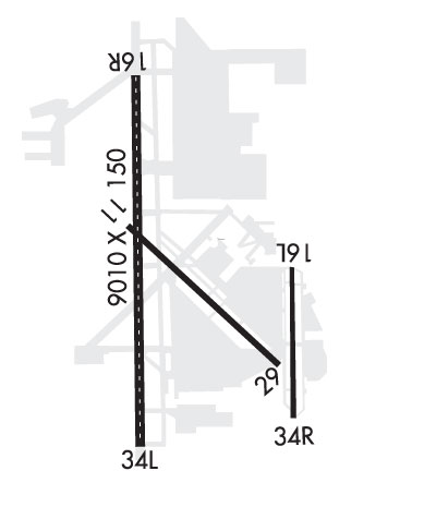
| Lat: N 4754.4 Long: W 12216.9 Elev: 608 Var: -16 Longest Runway: 9010 | ||
| Clr Del: 127.17 Dept. ATIS: 128.65 Arr. ATIS: 128.65 Ground: 121.8 Tower: 120.2/132.95 | ||
| ||||||||||||||||||||||||||||||
| ||||||||||||||||||||||||||||||
| ||||||||||||||||||||||||||||||
| ||||||||||||||||||||||||||||||
| FBOs at nearby airports who want your business: | |||||||||||
| |||||||||||
| Rwy | Rwy | |||||||
| 3004x75 | 3004' | 3004x75 | 3004' | |||||
| 9010x150 | 9010' | 109.30 - 163° | 9010x150 | 9010' | ||||
| Runway ID | Single Wheel | Double Wheel | Double Tandem Wheel | Dual Double Wheel |
| 16L/34R | 12,500 | N/A | N/A | N/A |
| 16R/34L | 100,000 | 200,000 | 350,000 | 830,000 |
| These numbers are Advisory and are not limits. The Airport Manager should have more accurate Weight Limits | ||||
 Airport Diagram might not be current. | |
| Facility Name: | SNOHOMISH COUNTY (PAINE FLD) |
| City Name: | EVERETT |
| County: | SNOHOMISH |
| State abbrev: | WA |
| State Name: | WASHINGTON |
| Ownership: | PUBLICLY OWNED |
| Use: | OPEN TO THE PUBLIC |
| Owner's Name: | SNOHOMISH COUNTY |
| Address: | 3000 ROCKEFELLER AVE. |
| EVERETT, WA 98201 | |
| Owner's Phone: | 425-388-3411 |
| Manager's Name: | ARIF GHOUSE |
| Address: | 3220 100TH ST SW |
| EVERETT, WA 98204 | |
| Phone: | (425) 388-5100 |
| FAA Region: | NORTHWEST MOUNTAIN |
| FAA Field Office: | SEA |
| Date | Sunrise | Sunset |
|---|---|---|
| 09/24/21 Friday | 6:58 | 19:03 |
| 09/25/21 Saturday | 7:00 | 19:01 |
| 09/26/21 Sunday | 7:01 | 18:59 |
| 09/27/21 Monday | 7:02 | 18:57 |
| 09/28/21 Tuesday | 7:04 | 18:55 |
| 09/29/21 Wednesday | 7:05 | 18:53 |
| 09/30/21 Thursday | 7:07 | 18:51 |
| 10/01/21 Friday | 7:08 | 18:49 |
| 10/02/21 Saturday | 7:09 | 18:47 |
| 10/03/21 Sunday | 7:11 | 18:45 |
| 10/04/21 Monday | 7:12 | 18:43 |
| 10/05/21 Tuesday | 7:14 | 18:41 |
| 10/06/21 Wednesday | 7:15 | 18:39 |
| 10/07/21 Thursday | 7:17 | 18:37 |
| Airport Attendance Schedule | NOV-APR 7 Days A Week 0700-2100, MAY-OCT 7 Days A Week 0700-2100 |
| Airport Status | OPERATIONAL (This Status can change at any time - please check NOTAMS) |
| Airport Lighting Schedule | WHEN ATCT CLSD ACTVT HIRL RY 16R/34L, MALSR RY 16R, & PAPI RY 34L - CTAF. |
| Airport Storage Available | Tie Downs, Hanger |
| Extra Services Available | Air Freight, Avionics, Charter, Flight Instruction, Aircraft Rental, Aircraft Sales |
| Wind Indicator | YES - (lighted) |
| Control Tower | YES |
| CTAF Frequency | 132.950 |
| Unicom Frequency | 122.950 |
| Rotating Beacon Color | CLEAR-GREEN (Light Land Airport) |
| Segmented Circle | YES |
| Landing Fee | YES; LNDG FEE FOR ACFT OVER 30000 LBS GWT. |
| Airport Inspected | FEDERAL - performed by FAA AIRPORTS FIELD PERSONNEL |
| Inspection Date | 03/16/2020 |
| Type of Fuel Available | Grade 100LL, JET A (freeze point -40C); -10100LL SELF SVC AVBL 24 HRS WITH CREDIT CARD AT CNTRL RAMP. HEL ARE PROHIBITED AT THE SELF SVC FUELING IS. FOR JET AND HEL FUEL AFT HRS CALL 425-355-6600. |
| Airframe Repair Service | MAJOR |
| Power Plant Repair Service | MAJOR |
| Latitude | N4754.4 |
| Longitude | W12216.9 (ESTIMATED) |
| Arpt Elevation | 606ft (SURVEYED) |
| Magnetic Variation | 16E |
| 6 miles SW | of EVERETT |
| Traffic Pattern Altitude | |
| Sectional Chart | SEATTLE |
| Operations (Reported) | Yearly | Avg. Daily |
|---|---|---|
| General Aviation Transient | 53908 | 148 |
| General Aviation Local | 56589 | 155 |
| Air Taxi | 1091 | 3 |
| Commerical | 2917 | 8 |
| Commuter | 0 | 0 |
| Military | 696 | 2 |
| Aircraft based on Field | |
|---|---|
| General Aviation Singles | 466 |
| General Aviation Multi | 48 |
| Jet Aircraft | 18 |
| General Aviation Helicopters | 4 |
| Military Aircraft | 0 |
| Gliders | 0 |
| Ultralights | 1 |
| FSS on field | NO |
| FSS tie-in | SEATTLE |
| FSS Phone | 1-800-WX-BRIEF |
| Who issues Notams | PAE |
| Notam D service at airport | YES |
| ARTCC Name | SEATTLE |
| Airport Certification | AIRPORT RECEIVING SCHEDULED AIR CARRIER SERVICE FROM CARRIERS CERTIFICATED BY THE CIVIL AERONAUTICS BOARD; ARPT CLSD TO UNSKED ACR OPNS WITH MORE THAN 30 PSGR SEATS 2100-0700 EXCP PPR CTC ARPT OPS 425-388-5125. |
| Aircraft Rescue & Firefighting Index | AIRPORT HAS A CERTIFICATE UNDER CFR PART 139 |
| Airport of Entry | No |
| Custom Landing Rights | YES |
| Joint Civil/Military | No |
| Military Landing rights | YES |
| NATIONAL PLAN OF INTEGRATED AIRPORT SYSTEMS (NPIAS) |
| GRANT AGREEMENTS UNDER FAAP/ADAP/AIP |
| SURPLUS PROPERTY AGREEMENT UNDER PUBLIC LAW 289 |
| ASSURANCES PURSUANT TO TITLE VI, CIVIL RIGHTS ACT OF 1964 |
| RWY 16L/34R CLSD BTN 0500-1500Z. |
| AVOID INT DEPS FM RWY 16L/34R |
| FLOCKS OF LRG & SML BIRDS INVOF ARPT. |
| ITNRNT DEP OF SML ACFT OVER 250 HORSEPOWER ON RWY 34R. |
| TWY A-2 RSTRD TO 30000 LBS. |
| AREAS NOT VSB FM ATCT INCL E EDGE OF S 1200 FT OF TWY A, TAXILANE E FM SE CORNER OF W HNGRS TO TWY A, TAXILANE H FROM NW EDGE OF W HNGRS TO TAXILANE E. |
| RWY 16L/34R LTD TO HEL 8000 LBS OR LESS. |
| FOR NOISE ABATEMENT FROM 0500-1500Z++ IF ACFT PERFORMANCE/WIND ALLOWS, USE RY 16R FOR ARRIVALS AND RY 34L FOR DEPARTURES. |
| TAXILANE E RSTD TO WINGSPAN LESS THAN 171 FT. ACFT WINGSPAN OF 171 FT OR GREATER ON TAXILANE E, TUG OPS ONLY. EAST 500 FT OF TAXILANE E RSTD TO WINGSPAN LESS THAN 49 FT. |
| TWY C BTN TRML RAMP AND CNTRL RAMP RSTRD TO WINGSPAN OF 68 FT OR LESS. TWY D, F, G AND L RSTRD TO WINGSPAN LESS THAN 49 FT. TWY A4, A5, K7 & B RSTRD TO WINGSPAN LESS THAN 118 FT. TAXILANE H RSTRD TO WINGSPAN LESS THAN 49 FT. |
| PAE HAS FAC CONSTRAINTS THAT LMT ITS ABILITY TO ACCOMMODATE DIVD FLTS AND MNTN THE ARPTS SAFE OPN DUR IREG OPS. ACFT OPR SHOULD CTCT THE ON-DUTY ARPT OPS PSNL (425-388-5125) TO COORD DIVD FLTS EXC IN THE CASE OF A DECLARED IN-FLT EMERG. |
| PPR RQRD FOR ACES ON BOEING RAMP. CTC BOEING FLT DISPATCH 206-544-5900 FOR APVL. PRIOR TO TAXI ONTO BOEING RAMP CTC BOEING RADIO TWR 123.475 OR CALL 425-342-5900. |
| NOISE SENSITIVE ARPT; FOR NOISE ABATEMENT PROC & TFC PROC CALL ARPT OPS 425-388-5125. |
| TWY K1 CLSD TO ACFT UNDER 30000 LBS. |
| TSNT HEL EXP LNDG/TKOF ON TWY B. |
| AIRFIELD CONDS NOT MNTD BTN 0000-0630. |
| EMERG FREQ 121.5 NOT MNT AT TWR. SEATTLE APP CON-TRACON MNT 121.5 FOR EVERETT (PAE). |
| FOR CD WHEN ATCT IS CLSD CTC SEATTLE APCH AT 206-214-4722. |
| TKOF CLNC RWY 16R FULL LEN; ENT RWY VIA TWY A1 UNLESS TWY AA SPECIFIED. |
| LRG ACFT FLY W PAT OVR WTR; SML ACFT FLY E PAT OVR ARPT. |
| USE CTN FOR 80 FT AGL LGT POLES SW EDGE OF BRAVO RAMP. |
| RWY 16R/34 TGL PROHIBITED MON-FRI FM 0700-0900. |
| IT IS REQ THAT PILOTS ADHERE TO THE FLW NOISE ABATEMENT PROC UNLESS OTRW INSTRD BY ATCT, ITNRNT ARR AND LOW APCH OF SML ACFT OVER 250 HORSEPOWER AUZ ON RWYS 16L AND 34R. |
| BE ALERT TO CNVG TFC ON BASE TO FINAL LEGS RWY 16R/34L 2100-0700. |
| AVOID LOW LVL OVRFLT OF BOEING RAMP; NE CORNER OF ARPT DUE TO JET BLAST. |
| TRNG FLTS DISCOURAGED AFT 2200. |
| RWY 16R/ 34LRY 16R/34L FIRST 1000 FT OF RY 16R IS CONCRETE. |
Airport Communications & Frequencies:
| |||||||||||||||||||||||||||||||
| Runway: 16L | Runway: 34R | ||
| Mag heading: | 164° | Mag heading: | 344° |
| Rwy Slope: | -.10% Down | Rwy Slope: | .10% Up |
| Approach: | Approach: | ||
| Pattern: | Left Traffic | Pattern: | Right Traffic |
| Markings: | BASIC | Markings: | BASIC |
| Marking Condition: | GOOD | Marking Condition: | GOOD |
| Arresting Dev: | Arresting Dev: | ||
| Lat & Long: | N4754.4 W12216.3 | Lat. & Long.: | N4753.9 W12216.3 |
| Elev: | 602.9 ft. MSL | Elev: | 599.8 ft. MSL |
| TCH: | 24 ft. AGL | TCH: | 22 ft. AGL |
| Visual Glide Path: | 3.25 degrees | Visual Glide Path: | 3.00 degrees |
| Displaced Threshold: | No | Displaced Threshold: | No |
| Touchdown Zone: | YES | Touchdown Zone: | YES |
| Touchdown Elev.: | 606.9 feet | Touchdown Elev.: | 606.9 feet |
| Visual Glide Slope: | 2-Light PAPI on LEFT side of Runway | Visual Glide Slope: | 2-Light PAPI on LEFT side of Runway |
| RVR Equipment: | RVR Equipment: | ||
| RVV Equipment: | NO | RVV Equipment: | NO |
| Approach Lights: | Approach Lights: | ||
| REIL: | YES | REIL: | YES |
| Centerline Lights: | NO | Centerline Lights: | NO |
| Touchdown lights: | NO | Touchdown lights: | NO |
| Runway Category: | Runway with a Visual Approach | Runway Category: | Runway with a Visual Approach |
| Declared Distances: | TORA:3004' TODA:3004' ASDA:3004' LDA:3004' | Declared Distances: | TORA:3004' TODA:3004' ASDA:3004' LDA:3004' |
| Obstructions: | POLE | Obstructions: | POLE |
| Marked: | NOT Marked/Lighted | Marked: | NOT Marked/Lighted |
| Clearance slope: | 22:1 | Clearance slope: | 20:1 |
| Obstruction height: | 9 feet AGL | Obstruction height: | 25 feet AGL |
| Dist. from runway: | 400 feet | Dist. from runway: | 690 feet |
| Centerline offset: | 100 left of centerline | Centerline offset: | 125 feet left of centerline |
| Comments: | Comments: |
| Runway: 16R | Runway: 34L | ||
| Mag heading: | 163° | Mag heading: | 343° |
| Rwy Slope: | .17% Up | Rwy Slope: | -.17% Down |
| Approach: | ILS | Approach: | |
| Pattern: | Right Traffic | Pattern: | Left Traffic |
| Markings: | PRECISION INSTRUMENT | Markings: | NONPRECISION INSTRUMENT |
| Marking Condition: | GOOD | Marking Condition: | GOOD |
| Arresting Dev: | Arresting Dev: | ||
| Lat & Long: | N4755.3 W12217.2 | Lat. & Long.: | N4753.8 W12217.1 |
| Elev: | 562.7 ft. MSL | Elev: | 577.6 ft. MSL |
| TCH: | 74 ft. AGL | TCH: | 75 ft. AGL |
| Visual Glide Path: | 3.00 degrees | Visual Glide Path: | 3.00 degrees |
| Displaced Threshold: | No | Displaced Threshold: | No |
| Touchdown Zone: | YES | Touchdown Zone: | YES |
| Touchdown Elev.: | 569.8 feet | Touchdown Elev.: | 583.4 feet |
| Visual Glide Slope: | 4-Light PAPI on RIGHT side of Runway | Visual Glide Slope: | 4-Light PAPI on LEFT side of Runway |
| RVR Equipment: | TOUCHDOWN-ROLLOUT | RVR Equipment: | TOUCHDOWN-ROLLOUT |
| RVV Equipment: | NO | RVV Equipment: | NO |
| Approach Lights: | MALSR - 1,400 foot medium intensity approach lighting system with runway alignment indicator lights | Approach Lights: | MALSF - 1,400 foot medium intensity approach lighting system with sequenced flashers |
| REIL: | NO | REIL: | NO |
| Centerline Lights: | YES | Centerline Lights: | YES |
| Touchdown lights: | YES | Touchdown lights: | NO |
| Runway Category: | Precision Instrument Runway | Runway Category: | Runway with a Non-precision Approach having visibility minimums greater than 3/4 mile |
| Declared Distances: | TORA:9010' TODA:9010' ASDA:9010' LDA:9010' | Declared Distances: | TORA:9010' TODA:9010' ASDA:9010' LDA:9010' |
| Obstructions: | Obstructions: | TREES | |
| Marked: | Marked: | NOT Marked/Lighted | |
| Clearance slope: | 50:1 | Clearance slope: | 30:1 |
| Obstruction height: | Obstruction height: | 125 feet AGL | |
| Dist. from runway: | Dist. from runway: | 4000 feet | |
| Centerline offset: | Centerline offset: | 930 feet right of centerline | |
| Comments: | Comments: |
Thanks for using FltPlan.com
all rights reserved © 1999-2021 by Flight Plan LLC


