
| AVI SUQUILLA PARKER AZ |
| |
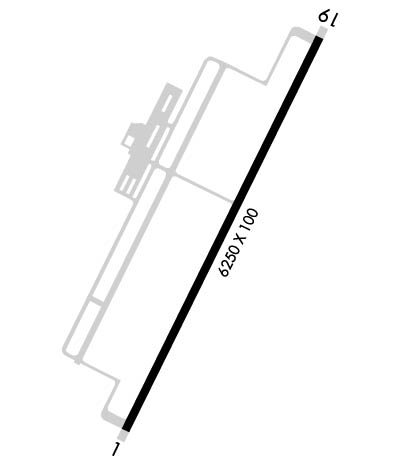
| Lat: N 3409.0 Long: W 11416.1 Elev: 458 Var: -14 Longest Runway: 6250 | ||
| AWOS: 132.75 CTAF: 122.72 | ||
| ||||||||||||||||||||||||||||||||||||||||||||
| ||||||||||||||||||||||||||||||||||||||||||||
| ||||||||||||||||||||||||||||||||||||||||||||
| Rwy | Rwy | |||||||
| 6250x100 | 6250' | 6250x100 | 6250' | |||||
| Runway ID | Single Wheel | Double Wheel | Double Tandem Wheel | Dual Double Wheel |
| 01/19 | 30,000 | 50,000 | N/A | N/A |
| These numbers are Advisory and are not limits. The Airport Manager should have more accurate Weight Limits | ||||
 Airport Diagram might not be current. | |
| Facility Name: | AVI SUQUILLA |
| City Name: | PARKER |
| County: | LA PAZ |
| State abbrev: | AZ |
| State Name: | ARIZONA |
| Ownership: | PUBLICLY OWNED |
| Use: | OPEN TO THE PUBLIC |
| Owner's Name: | COLORADO RIVER INDIAN TRIBES |
| Address: | 26600 MOHAVE ROAD |
| PARKER, AZ 85344 | |
| Owner's Phone: | 928-669-2168 |
| Manager's Name: | TED SWENDRA |
| Address: | 28940 AIRPORT ROAD |
| PARKER, AZ 85344 | |
| Phone: | 928-669-2168 |
| FAA Region: | WESTERN-PACIFIC |
| FAA Field Office: | PHX |
| Date | Sunrise | Sunset |
|---|---|---|
| 09/24/21 Friday | 6:26 | 18:31 |
| 09/25/21 Saturday | 6:27 | 18:30 |
| 09/26/21 Sunday | 6:28 | 18:28 |
| 09/27/21 Monday | 6:29 | 18:27 |
| 09/28/21 Tuesday | 6:29 | 18:26 |
| 09/29/21 Wednesday | 6:30 | 18:24 |
| 09/30/21 Thursday | 6:31 | 18:23 |
| 10/01/21 Friday | 6:31 | 18:21 |
| 10/02/21 Saturday | 6:32 | 18:20 |
| 10/03/21 Sunday | 6:33 | 18:19 |
| 10/04/21 Monday | 6:34 | 18:17 |
| 10/05/21 Tuesday | 6:34 | 18:16 |
| 10/06/21 Wednesday | 6:35 | 18:15 |
| 10/07/21 Thursday | 6:36 | 18:13 |
| Airport Attendance Schedule | 7 Days A Week 0800-1700 |
| Airport Status | OPERATIONAL (This Status can change at any time - please check NOTAMS) |
| Airport Lighting Schedule | ACTVT MIRL RWY 01/19; TWY LGTS - CTAF. |
| Airport Storage Available | Tie Downs, Hanger |
| Extra Services Available | NONE |
| Wind Indicator | YES - (lighted) |
| Control Tower | NO |
| CTAF Frequency | 122.725 |
| Unicom Frequency | 122.725 |
| Rotating Beacon Color | CLEAR-GREEN (Light Land Airport) |
| Segmented Circle | YES |
| Landing Fee | NO |
| Airport Inspected | STATE - performed by PRIVATE CONTRACT PERSONNEL |
| Inspection Date | 05/01/2019 |
| Type of Fuel Available | Grade 100LL, JET A (freeze point -40C); -10SVC FEE FOR FUEL WHEN ARPT UNATDD. |
| Airframe Repair Service | MINOR; FOR AIRFRAME/POWER PLANT REPAIRS CALL AMGR 928-669-2168. |
| Power Plant Repair Service | MINOR |
| Latitude | N3409.0 |
| Longitude | W11416.1 (ESTIMATED) |
| Arpt Elevation | 458ft (ESTIMATED) |
| Magnetic Variation | 14E |
| 1 miles E | of PARKER |
| Traffic Pattern Altitude | 800 |
| Sectional Chart | PHOENIX |
| Operations (Reported) | Yearly | Avg. Daily |
|---|---|---|
| General Aviation Transient | 13000 | 36 |
| General Aviation Local | 2000 | 5 |
| Air Taxi | 400 | 1 |
| Commerical | 0 | 0 |
| Commuter | 0 | 0 |
| Military | 600 | 2 |
| Aircraft based on Field | |
|---|---|
| General Aviation Singles | 7 |
| General Aviation Multi | 2 |
| Jet Aircraft | 0 |
| General Aviation Helicopters | 0 |
| Military Aircraft | 0 |
| Gliders | 0 |
| Ultralights | 0 |
| FSS on field | NO |
| FSS tie-in | PRESCOTT |
| FSS Phone | 1-800-WX-BRIEF |
| Who issues Notams | PRC |
| Notam D service at airport | YES |
| ARTCC Name | LOS ANGELES |
| Airport Certification | |
| Aircraft Rescue & Firefighting Index | None |
| Airport of Entry | No |
| Custom Landing Rights | No |
| Joint Civil/Military | No |
| Military Landing rights | YES |
| NATIONAL PLAN OF INTEGRATED AIRPORT SYSTEMS (NPIAS) |
| GRANT AGREEMENTS UNDER FAAP/ADAP/AIP |
| ASSURANCES PURSUANT TO TITLE VI, CIVIL RIGHTS ACT OF 1964 |
| RY 01/19 150 FT BLAST PADS BOTH ENDS. |
| RY 01/19 INTXN TAKE-OFFS PROHIBITED FM TWY A-2. |
| INTERMITTENT HIGH ALTITUDE MILITARY PARACHUTE ACTIVITY IN VICINITY OF AIRPORT. |
| FOR CD CTC LOS ANGELES ARTCC AT 661-575-2079. |
| ALL HELICOPTER OPS USE DESIGNATED HELIPADS ON NORTH RAMP. |
Airport Communications & Frequencies:
| |||||||||
| Runway: 01 | Runway: 19 | ||
| Mag heading: | 12° | Mag heading: | 192° |
| Rwy Slope: | .05% Up | Rwy Slope: | -.05% Down |
| Approach: | Approach: | ||
| Pattern: | Right Traffic | Pattern: | Left Traffic |
| Markings: | NONPRECISION INSTRUMENT | Markings: | NONPRECISION INSTRUMENT |
| Marking Condition: | POOR; NUMBERS AND CENTERLINE MARKINGS FADED & SOME MISSING. | Marking Condition: | POOR; NUMBERS AND CENTERLINE FADED AND SOME MISSING. |
| Arresting Dev: | Arresting Dev: | ||
| Lat & Long: | N3408.5 W11416.3 | Lat. & Long.: | N3409.5 W11415.8 |
| Elev: | 453.6 ft. MSL | Elev: | 456.8 ft. MSL |
| TCH: | 40 ft. AGL | TCH: | 40 ft. AGL |
| Visual Glide Path: | 3.00 degrees | Visual Glide Path: | 3.00 degrees |
| Displaced Threshold: | No | Displaced Threshold: | No |
| Touchdown Zone: | YES | Touchdown Zone: | YES |
| Touchdown Elev.: | 456.1 feet | Touchdown Elev.: | 458.4 feet |
| Visual Glide Slope: | 4-Light PAPI on LEFT side of Runway | Visual Glide Slope: | 4-Light PAPI on LEFT side of Runway |
| RVR Equipment: | RVR Equipment: | ||
| RVV Equipment: | NO | RVV Equipment: | NO |
| Approach Lights: | Approach Lights: | ||
| REIL: | NO | REIL: | NO |
| Centerline Lights: | NO | Centerline Lights: | NO |
| Touchdown lights: | NO | Touchdown lights: | NO |
| Runway Category: | Runway with a Non-precision Approach having visibility minimums greater than 3/4 mile | Runway Category: | Runway with a Visual Approach |
| Declared Distances: | Declared Distances: |
Thanks for using FltPlan.com
all rights reserved © 1999-2021 by Flight Plan LLC
