
| STELLAR AIRPARK CHANDLER AZ |
| |
| Lat: N 3317.9 Long: W 11154.9 Elev: 1179 Var: -09 Longest Runway: 4417 | ||
| CTAF: 122.97 | ||
| ||||||||||||||||||||||||||||||||||||||||||||
| ||||||||||||||||||||||||||||||||||||||||||||
| Rwy | Rwy | |||||||
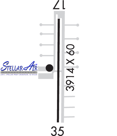
| 4417x80 | 4051' | 4417x80 | 4068' | |||||
| Runway ID | Single Wheel | Double Wheel | Double Tandem Wheel | Dual Double Wheel |
| 17/35 | N/A | N/A | N/A | N/A |
| These numbers are Advisory and are not limits. The Airport Manager should have more accurate Weight Limits | ||||
 Airport Diagram might not be current. | |
| Facility Name: | STELLAR AIRPARK |
| City Name: | CHANDLER |
| County: | MARICOPA |
| State abbrev: | AZ |
| State Name: | ARIZONA |
| Ownership: | PRIVATELY OWNED |
| Use: | OPEN TO THE PUBLIC |
| Owner's Name: | STELLAR RUNWAY UTILIZERS ASSN, INC. |
| Address: | 11 NORTH STELLAR PARKWAY |
| CHANDLER, AZ 85226 | |
| Owner's Phone: | 480-359-6575 |
| Manager's Name: | BOARD OF DIRECTORS |
| Address: | 11 NORTH STELLAR PARKWAY |
| CHANDLER, AZ 85226-3715 | |
| Phone: | 480-359-6575; AVBL TO ALL 7 MEMBER BOARD. |
| FAA Region: | WESTERN-PACIFIC |
| FAA Field Office: | PHX |
| Date | Sunrise | Sunset |
|---|---|---|
| 06/07/26 Sunday | 5:18 | 19:35 |
| 06/08/26 Monday | 5:18 | 19:36 |
| 06/09/26 Tuesday | 5:18 | 19:36 |
| 06/10/26 Wednesday | 5:18 | 19:37 |
| 06/11/26 Thursday | 5:18 | 19:37 |
| 06/12/26 Friday | 5:18 | 19:37 |
| 06/13/26 Saturday | 5:18 | 19:38 |
| 06/14/26 Sunday | 5:18 | 19:38 |
| 06/15/26 Monday | 5:18 | 19:39 |
| 06/16/26 Tuesday | 5:18 | 19:39 |
| 06/17/26 Wednesday | 5:18 | 19:39 |
| 06/18/26 Thursday | 5:18 | 19:39 |
| 06/19/26 Friday | 5:18 | 19:40 |
| 06/20/26 Saturday | 5:18 | 19:40 |
| Airport Attendance Schedule | UNATTENDED |
| Airport Status | OPERATIONAL (This Status can change at any time - please check NOTAMS) |
| Airport Lighting Schedule | DUSK-DAWN: ACTVT REIL RWY 17 & 35; MIRL RWY 17/35 - CTAF. |
| Airport Storage Available | NONE |
| Extra Services Available | NONE |
| Wind Indicator | YES - (unlit) |
| Control Tower | NO |
| CTAF Frequency | 122.975 |
| Unicom Frequency | 122.975 |
| Rotating Beacon Color | WG |
| Segmented Circle | NO |
| Landing Fee | NO |
| Airport Inspected | STATE - performed by PRIVATE CONTRACT PERSONNEL |
| Inspection Date | 04/20/2024 |
| Type of Fuel Available | Grade 100LL, JET A (freeze point -40C); -10SELF SVC H24; INFO 623-277-0000.; -A PPR - 602-750-2226. |
| Airframe Repair Service | MINOR |
| Power Plant Repair Service | MINOR |
| Latitude | N3317.9 |
| Longitude | W11154.9 (ESTIMATED) |
| Arpt Elevation | 1178ft (SURVEYED) |
| Magnetic Variation | 09E |
| 3 miles W | of CHANDLER |
| Traffic Pattern Altitude | 823 |
| Sectional Chart | PHOENIX |
| Operations (Reported) | Yearly | Avg. Daily |
|---|---|---|
| General Aviation Transient | 0 | 0 |
| General Aviation Local | 0 | 0 |
| Air Taxi | 0 | 0 |
| Commerical | 0 | 0 |
| Commuter | 0 | 0 |
| Military | 0 | 0 |
| Aircraft based on Field | |
|---|---|
| General Aviation Singles | 0 |
| General Aviation Multi | 0 |
| Jet Aircraft | 0 |
| General Aviation Helicopters | 0 |
| Military Aircraft | 0 |
| Gliders | 0 |
| Ultralights | 0 |
| FSS on field | NO |
| FSS tie-in | PRESCOTT |
| FSS Phone | 1-800-WX-BRIEF |
| Who issues Notams | PRC |
| Notam D service at airport | YES |
| ARTCC Name | ALBUQUERQUE |
| Airport Certification | |
| Aircraft Rescue & Firefighting Index | None |
| Airport of Entry | No |
| Custom Landing Rights | No |
| Joint Civil/Military | No |
| Military Landing rights | No |
| ALERT: NON RADIO ACFT & BIRDS ON & INVOF ARPT. |
| TSNT CRTFYD FOR 15000 GROSS TKOF WEIGHT PPR. |
| FOR CD CTC PHOENIX APCH AT 602-306-2565. |
| TRNG TGL & TRNG HEL NA. |
| AVOID OTFC OF NOISE SENS AREA W OF RWY 17/35 & N OF ARPT. |
| COML & STUDENT TRNG OPS PMT ONLY. |
| FLOOD IRRIGATION BTW RWY & TWY; WATER UP TO 1 FT IREG SKED. |
| ENG RUNUP USE E SIDE AREA. |
| RWY 17/3 5 RWY 17 CALM WIND RWY. |
Airport Communications & Frequencies:
| ||||||||||||||
| Runway: 17 | Runway: 35 | ||
| Mag heading: | 171° | Mag heading: | 351° |
| Rwy Slope: | -.10% Down | Rwy Slope: | .10% Up |
| Approach: | Approach: | ||
| Pattern: | Left Traffic | Pattern: | Left Traffic |
| Markings: | NONPRECISION INSTRUMENT | Markings: | NONPRECISION INSTRUMENT |
| Marking Condition: | GOOD | Marking Condition: | GOOD |
| Arresting Dev: | Arresting Dev: | ||
| Lat & Long: | N3318.3 W11154.9 | Lat. & Long.: | N3317.6 W11154.9 |
| Elev: | 1178.0 ft. MSL | Elev: | 1173.7 ft. MSL |
| TCH: | 39 ft. AGL | TCH: | 40 ft. AGL |
| Visual Glide Path: | 3.25 degrees | Visual Glide Path: | 3.25 degrees |
| Displaced Threshold: | 366 feet | Displaced Threshold: | 349 feet |
| Touchdown Zone: | YES | Touchdown Zone: | YES |
| Touchdown Elev.: | 1178.3 feet | Touchdown Elev.: | 1177.5 feet |
| Visual Glide Slope: | 2-Light PAPI on LEFT side of Runway | Visual Glide Slope: | 2-Light PAPI on RIGHT side of Runway |
| RVR Equipment: | RVR Equipment: | ||
| RVV Equipment: | NO | RVV Equipment: | NO |
| Approach Lights: | Approach Lights: | ||
| REIL: | YES | REIL: | YES |
| Centerline Lights: | NO | Centerline Lights: | NO |
| Touchdown lights: | NO | Touchdown lights: | NO |
| Runway Category: | Runway with a Visual Approach | Runway Category: | Runway with a Non-precision Approach |
| Declared Distances: | LDA:4051' | Declared Distances: | LDA:4068' |
| Obstructions: | ROAD | Obstructions: | TREE |
| Marked: | NOT Marked/Lighted | Marked: | NOT Marked/Lighted |
| Clearance slope: | 50:1 SLOPE TO DTHR; 11 FT TREE 565 FT FM DTHR 10 FT L OF CNTRLN. | Clearance slope: | 1:1; APCH SLOPE 22:1 TO DTHR. |
| Obstruction height: | 15 feet AGL | Obstruction height: | 11 feet AGL |
| Dist. from runway: | 201 feet | Dist. from runway: | 216 feet |
| Centerline offset: | Centerline offset: | 10 feet left of centerline | |
| Comments: | +8 FT FENCE 130 FT FM RWY END; +15 FT ROAD 164 FT FM RWY END ACRS THR. | Comments: | +6 FT FENCE 80 FT FM RWY END ACRS THR; +15 FT ROAD 85 FT FM RWY END ACRS THR. |
Thanks for using FltPlan.com
all rights reserved © 1999-2026 by Flight Plan LLC
