| KNOXVILLE MUNI KNOXVILLE IA |
| |
| Lat: N 4117.9 Long: W 09306.8 Elev: 928 Var: -02 Longest Runway: 4000 | ||
| AWOS: 119.77 CTAF: 122.8 | ||
| |||||||||||||||||||||||
| |||||||||||||||||||||||
| |||||||||||||||||||||||
| Rwy | Rwy | |||||||
| 4000x75 | 4000' | 4000x75 | 4000' | |||||
| Runway ID | Single Wheel | Double Wheel | Double Tandem Wheel | Dual Double Wheel |
| 15/33 | 28,000 | 48,000 | N/A | N/A |
| These numbers are Advisory and are not limits. The Airport Manager should have more accurate Weight Limits | ||||
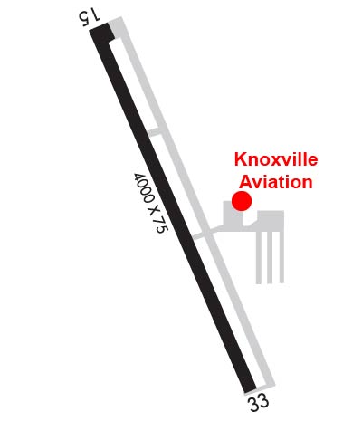 Airport Diagram might not be current. | |
| Facility Name: | KNOXVILLE MUNI |
| City Name: | KNOXVILLE |
| County: | MARION |
| State abbrev: | IA |
| State Name: | IOWA |
| Ownership: | PUBLICLY OWNED |
| Use: | OPEN TO THE PUBLIC |
| Owner's Name: | CITY OF KNOXVILLE |
| Address: | 305 SOUTH 3RD |
| KNOXVILLE, IA 50138 | |
| Owner's Phone: | 641-842-3147 |
| Manager's Name: | DAN VAN DONSELAAR |
| Address: | 1545 HWY 14 SOUTH |
| KNOXVILLE, IA 50138 | |
| Phone: | 641-842-4423 |
| FAA Region: | CENTRAL |
| FAA Field Office: | NONE |
| Date | Sunrise | Sunset |
|---|---|---|
| 09/24/21 Friday | 7:02 | 19:07 |
| 09/25/21 Saturday | 7:03 | 19:05 |
| 09/26/21 Sunday | 7:04 | 19:03 |
| 09/27/21 Monday | 7:05 | 19:01 |
| 09/28/21 Tuesday | 7:06 | 19:00 |
| 09/29/21 Wednesday | 7:07 | 18:58 |
| 09/30/21 Thursday | 7:08 | 18:56 |
| 10/01/21 Friday | 7:09 | 18:55 |
| 10/02/21 Saturday | 7:10 | 18:53 |
| 10/03/21 Sunday | 7:11 | 18:51 |
| 10/04/21 Monday | 7:12 | 18:50 |
| 10/05/21 Tuesday | 7:13 | 18:48 |
| 10/06/21 Wednesday | 7:14 | 18:46 |
| 10/07/21 Thursday | 7:15 | 18:45 |
| Airport Attendance Schedule | 7 Days A Week DAWN-DUSK; FOR SERVICE AFTER HOURS CALL 641-842-4423 OR 641-891-6824. |
| Airport Status | OPERATIONAL (This Status can change at any time - please check NOTAMS) |
| Airport Lighting Schedule | ACTVT MIRL RY 15/33 AND PAPI RYS 15 & 33 AND REIL RYS 15 & 33 - CTAF. |
| Airport Storage Available | Tie Downs, Hanger |
| Extra Services Available | Charter, Flight Instruction, Aircraft Rental, Aircraft Sales |
| Wind Indicator | YES - (lighted) |
| Control Tower | NO |
| CTAF Frequency | 122.800 |
| Unicom Frequency | 122.800 |
| Rotating Beacon Color | CLEAR-GREEN (Light Land Airport) |
| Segmented Circle | NO |
| Landing Fee | NO |
| Airport Inspected | STATE - performed by STATE AERONAUTICAL PERSONNEL |
| Inspection Date | 10/16/2020 |
| Type of Fuel Available | Grade 100LL, JET A (freeze point -40C) |
| Airframe Repair Service | MAJOR |
| Power Plant Repair Service | MAJOR |
| Latitude | N4117.9 |
| Longitude | W09306.8 (ESTIMATED) |
| Arpt Elevation | 928ft (SURVEYED) |
| Magnetic Variation | 02E |
| 2 miles S | of KNOXVILLE |
| Traffic Pattern Altitude | |
| Sectional Chart | OMAHA |
| Operations (Reported) | Yearly | Avg. Daily |
|---|---|---|
| General Aviation Transient | 5102 | 14 |
| General Aviation Local | 5670 | 16 |
| Air Taxi | 113 | 0 |
| Commerical | 0 | 0 |
| Commuter | 0 | 0 |
| Military | 115 | 0 |
| Aircraft based on Field | |
|---|---|
| General Aviation Singles | 32 |
| General Aviation Multi | 1 |
| Jet Aircraft | 0 |
| General Aviation Helicopters | 3 |
| Military Aircraft | 0 |
| Gliders | 0 |
| Ultralights | 1 |
| FSS on field | NO |
| FSS tie-in | FORT DODGE |
| FSS Phone | 1-800-WX-BRIEF |
| Who issues Notams | OXV |
| Notam D service at airport | YES |
| ARTCC Name | CHICAGO |
| Airport Certification | |
| Aircraft Rescue & Firefighting Index | None |
| Airport of Entry | No |
| Custom Landing Rights | No |
| Joint Civil/Military | No |
| Military Landing rights | YES |
| NATIONAL PLAN OF INTEGRATED AIRPORT SYSTEMS (NPIAS) |
| GRANT AGREEMENTS UNDER FAAP/ADAP/AIP |
| ASSURANCES PURSUANT TO TITLE VI, CIVIL RIGHTS ACT OF 1964 |
| FOR CD CTC DES MOINES ATCT AT 515-974- 8016. |
Airport Communications & Frequencies:
| ||||||||||||||
| Runway: 15 | Runway: 33 | ||
| Mag heading: | 154° | Mag heading: | 334° |
| Rwy Slope: | .09% Up | Rwy Slope: | -.09% Down |
| Approach: | Approach: | ||
| Pattern: | Left Traffic | Pattern: | Left Traffic |
| Markings: | NONPRECISION INSTRUMENT | Markings: | NONPRECISION INSTRUMENT |
| Marking Condition: | GOOD | Marking Condition: | GOOD |
| Arresting Dev: | Arresting Dev: | ||
| Lat & Long: | N4118.2 W09307.0 | Lat. & Long.: | N4117.6 W09306.6 |
| Elev: | 923.9 ft. MSL | Elev: | 927.4 ft. MSL |
| TCH: | 32 ft. AGL | TCH: | 32 ft. AGL |
| Visual Glide Path: | 3.00 degrees | Visual Glide Path: | 3.00 degrees |
| Displaced Threshold: | No | Displaced Threshold: | No |
| Touchdown Zone: | YES | Touchdown Zone: | YES |
| Touchdown Elev.: | 927.8 feet | Touchdown Elev.: | 928.3 feet |
| Visual Glide Slope: | 2-Light PAPI on LEFT side of Runway | Visual Glide Slope: | 2-Light PAPI on LEFT side of Runway |
| RVR Equipment: | RVR Equipment: | ||
| RVV Equipment: | NO | RVV Equipment: | NO |
| Approach Lights: | Approach Lights: | ||
| REIL: | YES | REIL: | YES |
| Centerline Lights: | NO | Centerline Lights: | NO |
| Touchdown lights: | NO | Touchdown lights: | NO |
| Runway Category: | Runway with a Non-precision Approach having visibility minimums greater than 3/4 mile | Runway Category: | Runway with a Non-precision Approach having visibility minimums greater than 3/4 mile |
| Declared Distances: | Declared Distances: | ||
| Obstructions: | POLE | Obstructions: | TREE |
| Marked: | NOT Marked/Lighted | Marked: | NOT Marked/Lighted |
| Clearance slope: | 23:1 | Clearance slope: | 24:1 |
| Obstruction height: | 26 feet AGL | Obstruction height: | 23 feet AGL |
| Dist. from runway: | 819 feet | Dist. from runway: | 773 feet |
| Centerline offset: | 325 left of centerline | Centerline offset: | 99 feet right of centerline |
| Comments: | Comments: |
Thanks for using FltPlan.com
all rights reserved © 1999-2021 by Flight Plan LLC