
| OCEAN CITY MUNI OCEAN CITY MD |
| |
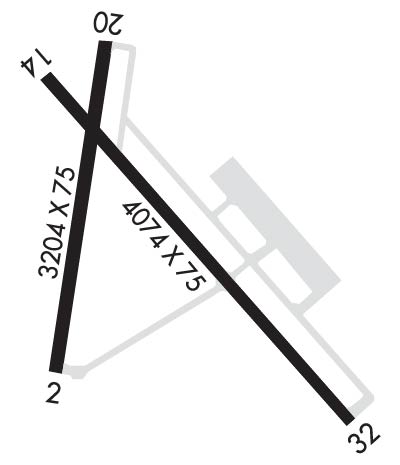
| Lat: N 3818.6 Long: W 07507.4 Elev: 16 Var: +12 Longest Runway: 4074 | ||
| Clr Del: 127.25 AWOS: 119.02 CTAF: 123.05 | ||
| ||||||||||||||||||||||||||||||||||||||||||||
| ||||||||||||||||||||||||||||||||||||||||||||
| ||||||||||||||||||||||||||||||||||||||||||||
| Rwy | Rwy | |||||||
| 3204x75 | 3204' | 3204x75 | 3204' | |||||
| 4074x75 | 4074' | 4074x75 | 4074' | 109.15 - 325° | ||||
| Runway ID | Single Wheel | Double Wheel | Double Tandem Wheel | Dual Double Wheel |
| 02/20 | N/A | N/A | N/A | N/A |
| 14/32 | 45,000 | 75,000 | N/A | N/A |
| These numbers are Advisory and are not limits. The Airport Manager should have more accurate Weight Limits | ||||
 Airport Diagram might not be current. | |
| Facility Name: | OCEAN CITY MUNI |
| City Name: | OCEAN CITY |
| County: | WORCESTER |
| State abbrev: | MD |
| State Name: | MARYLAND |
| Ownership: | PUBLICLY OWNED |
| Use: | OPEN TO THE PUBLIC |
| Owner's Name: | MAYOR & CITY COUNCIL |
| Address: | 301 N. BALTMORE AVE |
| OCEAN CITY, MD 21842 | |
| Owner's Phone: | 410-213-2471 |
| Manager's Name: | JAIME GIANDOMENICO |
| Address: | 12724 AIRPORT RD |
| BERLIN, MD 21811 | |
| Phone: | (443) 235-4434 |
| FAA Region: | EASTERN |
| FAA Field Office: | DCA |
| Date | Sunrise | Sunset |
|---|---|---|
| 06/08/26 Monday | 5:37 | 20:22 |
| 06/09/26 Tuesday | 5:37 | 20:23 |
| 06/10/26 Wednesday | 5:37 | 20:23 |
| 06/11/26 Thursday | 5:36 | 20:24 |
| 06/12/26 Friday | 5:36 | 20:24 |
| 06/13/26 Saturday | 5:36 | 20:25 |
| 06/14/26 Sunday | 5:36 | 20:25 |
| 06/15/26 Monday | 5:36 | 20:26 |
| 06/16/26 Tuesday | 5:36 | 20:26 |
| 06/17/26 Wednesday | 5:36 | 20:26 |
| 06/18/26 Thursday | 5:37 | 20:27 |
| 06/19/26 Friday | 5:37 | 20:27 |
| 06/20/26 Saturday | 5:37 | 20:27 |
| 06/21/26 Sunday | 5:37 | 20:27 |
| Airport Attendance Schedule | 7 Days A Week 0800-1700 |
| Airport Status | OPERATIONAL (This Status can change at any time - please check NOTAMS) |
| Airport Lighting Schedule | MIRL RWYS 02/20 & 14/32 OPR SS-SR AND PRESET LOW INTST; INCR INTST & ACTVT REIL RWY 02, 14, 20 & 32 - CTAF. PAPI RWY 02, 14, 20 & 32 OPR CONSLY. |
| Airport Storage Available | Tie Downs, Hanger |
| Extra Services Available | Charter, Flight Instruction, Parachute Jumping, Aircraft Rental, Aircraft Sales, Annual Surveying |
| Wind Indicator | YES - (lighted) |
| Control Tower | NO |
| CTAF Frequency | 123.050 |
| Unicom Frequency | 123.050 |
| Rotating Beacon Color | WG |
| Segmented Circle | YES |
| Landing Fee | NO |
| Airport Inspected | STATE - performed by STATE AERONAUTICAL PERSONNEL |
| Inspection Date | 06/03/2025 |
| Type of Fuel Available | Grade 100LL, JET A (freeze point -40C); -1024 HR SELF SERVE 100LL AVBL WITH CREDIT CARD. |
| Airframe Repair Service | MAJOR |
| Power Plant Repair Service | MAJOR |
| Latitude | N3818.6 |
| Longitude | W07507.4 (ESTIMATED) |
| Arpt Elevation | 15ft (SURVEYED) |
| Magnetic Variation | 12W |
| 2 miles SW | of OCEAN CITY |
| Traffic Pattern Altitude | |
| Sectional Chart | WASHINGTON |
| Operations (Reported) | Yearly | Avg. Daily |
|---|---|---|
| General Aviation Transient | 0 | 0 |
| General Aviation Local | 0 | 0 |
| Air Taxi | 0 | 0 |
| Commerical | 0 | 0 |
| Commuter | 0 | 0 |
| Military | 0 | 0 |
| Aircraft based on Field | |
|---|---|
| General Aviation Singles | 0 |
| General Aviation Multi | 0 |
| Jet Aircraft | 0 |
| General Aviation Helicopters | 0 |
| Military Aircraft | 0 |
| Gliders | 0 |
| Ultralights | 0 |
| FSS on field | NO |
| FSS tie-in | LEESBURG |
| FSS Phone | 1-800-WX-BRIEF |
| Who issues Notams | OXB |
| Notam D service at airport | YES |
| ARTCC Name | WASHINGTON |
| Airport Certification | |
| Aircraft Rescue & Firefighting Index | None |
| Airport of Entry | No |
| Custom Landing Rights | No |
| Joint Civil/Military | No |
| Military Landing rights | YES |
| NATIONAL PLAN OF INTEGRATED AIRPORT SYSTEMS (NPIAS) |
| GRANT AGREEMENTS UNDER FAAP/ADAP/AIP |
| DEER & BIRDS ON & INVOF ARPT. |
| TRUCKS AND VEHICLES CROSSING TWY, NORTH OF HOLD BLOCK RWY 02. |
| FOR CD CTC PATUXENT APCH AT 301-342-3740, WHEN PATUXENT APCH IS CLSD CTC POTOMAC APCH AT 866-640-4124. |
Airport Communications & Frequencies:
| |||||||||||||||||||||||||||||
| Runway: 02 | Runway: 20 | ||
| Mag heading: | 22° | Mag heading: | 202° |
| Rwy Slope: | .07% Up | Rwy Slope: | -.07% Down |
| Approach: | Approach: | ||
| Pattern: | Left Traffic | Pattern: | Left Traffic |
| Markings: | NONPRECISION INSTRUMENT | Markings: | NONPRECISION INSTRUMENT |
| Marking Condition: | GOOD | Marking Condition: | GOOD |
| Arresting Dev: | Arresting Dev: | ||
| Lat & Long: | N3818.4 W07507.7 | Lat. & Long.: | N3818.9 W07507.5 |
| Elev: | 8.8 ft. MSL | Elev: | 11.1 ft. MSL |
| TCH: | 40 ft. AGL | TCH: | 42 ft. AGL |
| Visual Glide Path: | 3.00 degrees | Visual Glide Path: | 4.00 degrees |
| Displaced Threshold: | No | Displaced Threshold: | No |
| Touchdown Zone: | YES | Touchdown Zone: | YES |
| Touchdown Elev.: | 11.5 feet | Touchdown Elev.: | 11.5 feet |
| Visual Glide Slope: | 2-Light PAPI on LEFT side of Runway; PAPI UNUSBL BYD 6 DEG LEFT OF CNTRLN. | Visual Glide Slope: | 2-Light PAPI on LEFT side of Runway |
| RVR Equipment: | RVR Equipment: | ||
| RVV Equipment: | NO | RVV Equipment: | NO |
| Approach Lights: | Approach Lights: | ||
| REIL: | YES | REIL: | YES |
| Centerline Lights: | NO | Centerline Lights: | NO |
| Touchdown lights: | NO | Touchdown lights: | NO |
| Runway Category: | Runway with a Non-precision Approach | Runway Category: | Runway with a Visual Approach |
| Declared Distances: | Declared Distances: | ||
| Comments: | 40 FT TREES 177 FT 'L' OF RWY CNTRLN. | Comments: |
| Runway: 14 | Runway: 32 | ||
| Mag heading: | 145° | Mag heading: | 325° |
| Rwy Slope: | -.12% Down | Rwy Slope: | .12% Up |
| Approach: | Approach: | LOC/DME | |
| Pattern: | Left Traffic | Pattern: | Left Traffic |
| Markings: | NONPRECISION INSTRUMENT | Markings: | NONPRECISION INSTRUMENT |
| Marking Condition: | GOOD | Marking Condition: | GOOD |
| Arresting Dev: | Arresting Dev: | ||
| Lat & Long: | N3818.8 W07507.6 | Lat. & Long.: | N3818.4 W07507.0 |
| Elev: | 15.9 ft. MSL | Elev: | 11.2 ft. MSL |
| TCH: | 48 ft. AGL | TCH: | 35 ft. AGL |
| Visual Glide Path: | 4.00 degrees | Visual Glide Path: | 3.00 degrees |
| Displaced Threshold: | No | Displaced Threshold: | No |
| Touchdown Zone: | YES | Touchdown Zone: | YES |
| Touchdown Elev.: | 15.9 feet | Touchdown Elev.: | 11.2 feet |
| Visual Glide Slope: | 2-Light PAPI on LEFT side of Runway | Visual Glide Slope: | 4-Light PAPI on LEFT side of Runway |
| RVR Equipment: | RVR Equipment: | ||
| RVV Equipment: | NO | RVV Equipment: | NO |
| Approach Lights: | Approach Lights: | ||
| REIL: | YES | REIL: | YES |
| Centerline Lights: | NO | Centerline Lights: | NO |
| Touchdown lights: | NO | Touchdown lights: | NO |
| Runway Category: | Runway with a Non-precision Approach | Runway Category: | Runway with a Non-precision Approach |
| Declared Distances: | Declared Distances: | ||
| Obstructions: | TREES | Obstructions: | |
| Marked: | NOT Marked/Lighted | Marked: | |
| Clearance slope: | 17:1 | Clearance slope: | 50:1 |
| Obstruction height: | 65 feet AGL | Obstruction height: | |
| Dist. from runway: | 1329 feet | Dist. from runway: | |
| Centerline offset: | 46 right of centerline | Centerline offset: | |
| Comments: | 8 FT GRND/BRSH 180 FT 'R' OF RWY CNTRLN. | Comments: |
Thanks for using FltPlan.com
all rights reserved © 1999-2026 by Flight Plan LLC
