
| NORWOOD MEMORIAL NORWOOD MA |
| |
| Lat: N 4211.4 Long: W 07110.4 Elev: 49 Var: +15 Longest Runway: 4007 | ||
| Clr Del: 121.8 Dept. ATIS: 119.95 Arr. ATIS: 119.95 Ground: 121.8 Tower: 126.0 | ||
| ||||||||||||||||||||||||||||||||||||||||||||
| ||||||||||||||||||||||||||||||||||||||||||||
| ||||||||||||||||||||||||||||||||||||||||||||
| ||||||||||||||||||||||||||||||||||||||||||||
| ||||||||||||||||||||||||||||||||||||||||||||
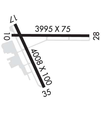
| Rwy | Rwy | |||||||
| 3995x75 | 3008' | 3995x75 | 3783' | |||||
| 4007x100 | 4007' | 4007x100 | 4007' | 108.30 - 349° | ||||
| Runway ID | Single Wheel | Double Wheel | Double Tandem Wheel | Dual Double Wheel |
| 10/28 | 58,000 | 69,000 | N/A | N/A |
| 17/35 | 58,000 | 69,000 | N/A | N/A |
| These numbers are Advisory and are not limits. The Airport Manager should have more accurate Weight Limits | ||||
 Airport Diagram might not be current. | |
| Facility Name: | NORWOOD MEML |
| City Name: | NORWOOD |
| County: | NORFOLK |
| State abbrev: | MA |
| State Name: | MASSACHUSETTS |
| Ownership: | PUBLICLY OWNED |
| Use: | OPEN TO THE PUBLIC |
| Owner's Name: | TOWN OF NORWOOD |
| Address: | 566 WASHINGTON STREET |
| NORWOOD, MA 02062 | |
| Owner's Phone: | 781-762-1240 |
| Manager's Name: | RUSS MAGUIRE |
| Address: | 111 ACCESS ROAD |
| NORWOOD, MA 02062 | |
| Phone: | 781-255-5615 |
| FAA Region: | NEW ENGLAND |
| FAA Field Office: | NONE |
| Date | Sunrise | Sunset |
|---|---|---|
| 09/24/21 Friday | 6:34 | 18:39 |
| 09/25/21 Saturday | 6:35 | 18:37 |
| 09/26/21 Sunday | 6:36 | 18:35 |
| 09/27/21 Monday | 6:37 | 18:34 |
| 09/28/21 Tuesday | 6:38 | 18:32 |
| 09/29/21 Wednesday | 6:39 | 18:30 |
| 09/30/21 Thursday | 6:40 | 18:28 |
| 10/01/21 Friday | 6:41 | 18:27 |
| 10/02/21 Saturday | 6:42 | 18:25 |
| 10/03/21 Sunday | 6:44 | 18:23 |
| 10/04/21 Monday | 6:45 | 18:22 |
| 10/05/21 Tuesday | 6:46 | 18:20 |
| 10/06/21 Wednesday | 6:47 | 18:18 |
| 10/07/21 Thursday | 6:48 | 18:16 |
| Airport Attendance Schedule | MON - FRI 0800-1700 |
| Airport Status | OPERATIONAL (This Status can change at any time - please check NOTAMS) |
| Airport Lighting Schedule | WHEN ATCT CLSD ACTVT MALSF RWY 35; PAPI RWYS 10, 17, 35; MIRL 17/35 - CTAF. |
| Airport Storage Available | Tie Downs, Hanger |
| Extra Services Available | Air Ambulance, Charter, Flight Instruction, Aircraft Rental, Aircraft Sales, Annual Surveying |
| Wind Indicator | YES - (lighted) |
| Control Tower | YES |
| CTAF Frequency | 126.000 |
| Unicom Frequency | |
| Rotating Beacon Color | CLEAR-GREEN (Light Land Airport) |
| Segmented Circle | NO |
| Landing Fee | NO |
| Airport Inspected | STATE - performed by STATE AERONAUTICAL PERSONNEL |
| Inspection Date | 02/28/2020 |
| Type of Fuel Available | Grade 100LL, JET A (freeze point -40C) |
| Airframe Repair Service | MAJOR |
| Power Plant Repair Service | MAJOR |
| Latitude | N4211.4 |
| Longitude | W07110.4 (ESTIMATED) |
| Arpt Elevation | 49ft (SURVEYED) |
| Magnetic Variation | 15W |
| 2 miles E | of NORWOOD |
| Traffic Pattern Altitude | |
| Sectional Chart | NEW YORK |
| Operations (Reported) | Yearly | Avg. Daily |
|---|---|---|
| General Aviation Transient | 29242 | 80 |
| General Aviation Local | 24234 | 66 |
| Air Taxi | 5057 | 14 |
| Commerical | 0 | 0 |
| Commuter | 0 | 0 |
| Military | 95 | 0 |
| Aircraft based on Field | |
|---|---|
| General Aviation Singles | 83 |
| General Aviation Multi | 10 |
| Jet Aircraft | 10 |
| General Aviation Helicopters | 16 |
| Military Aircraft | 0 |
| Gliders | 0 |
| Ultralights | 0 |
| FSS on field | NO |
| FSS tie-in | BRIDGEPORT |
| FSS Phone | 1-800-WX-BRIEF |
| Who issues Notams | OWD |
| Notam D service at airport | YES |
| ARTCC Name | BOSTON |
| Airport Certification | |
| Aircraft Rescue & Firefighting Index | None |
| Airport of Entry | No |
| Custom Landing Rights | No |
| Joint Civil/Military | No |
| Military Landing rights | YES |
| NATIONAL PLAN OF INTEGRATED AIRPORT SYSTEMS (NPIAS) |
| GRANT AGREEMENTS UNDER FAAP/ADAP/AIP |
| ASSURANCES PURSUANT TO TITLE VI, CIVIL RIGHTS ACT OF 1964 |
| AGREEMENT UNDER DLAND OR DCLA HAS EXPIRED. |
| 1199 FT /1349 FT MSL/ AND 1249 FT /1349 FT MSL/ TV TWR 8 NM NNW. 1063.5 FT /1184 FT MSL/ TWR 8.5 NM NNW. |
| ALL ACFT EXCEEDING 87 EFFECTIVE PERCEIVED NOISE LEVEL IN DECIBELS OR 75 DECIBELS, AS MEASURED IN PART 36 PROHIBITED FROM USING ARPT. |
| 125 FT FLAGPOLE 1 MILE NW OF RWY 17 APCH. |
| GATE 2 TXL LTD TO ACFT WITH WINGSPANS OF 50 FT OR LESS. GATE 3 TXL LTD TO ACFT WITH WINGSPANS OF 45 FT OR LESS. |
| BIRD ACTVTY & WILDLIFE INVOF ARPT. |
| SN REMOVAL EQUIP BLDG (ABUTTING SOUTH APRON). |
| LDG FEES FOR TSNT FIXED-WING ACFT WITH MORE THAN 5000 LBS MAX TOG, AS WELL AS TSNT HELS REGARDLESS OF WT. |
Airport Communications & Frequencies:
| ||||||||||||||||||||||
| Runway: 10 | Runway: 28 | ||
| Mag heading: | 104° | Mag heading: | 284° |
| Rwy Slope: | -.06% Down | Rwy Slope: | .06% Up |
| Approach: | Approach: | ||
| Pattern: | Left Traffic | Pattern: | Right Traffic; RIGHT TFC FOR TGL ONLY. |
| Markings: | BASIC | Markings: | BASIC |
| Marking Condition: | GOOD | Marking Condition: | GOOD |
| Arresting Dev: | Arresting Dev: | ||
| Lat & Long: | N4211.5 W07110.7 | Lat. & Long.: | N4211.5 W07109.8 |
| Elev: | 48.4 ft. MSL | Elev: | 46.1 ft. MSL |
| TCH: | 25 ft. AGL | TCH: | |
| Visual Glide Path: | 4.00 degrees | Visual Glide Path: | |
| Displaced Threshold: | 987 feet | Displaced Threshold: | 212 feet |
| Touchdown Zone: | YES | Touchdown Zone: | YES |
| Touchdown Elev.: | 47.8 feet | Touchdown Elev.: | 48.0 feet |
| Visual Glide Slope: | 4-Light PAPI on RIGHT side of Runway | Visual Glide Slope: | |
| RVR Equipment: | RVR Equipment: | ||
| RVV Equipment: | NO | RVV Equipment: | NO |
| Approach Lights: | Approach Lights: | ||
| REIL: | NO | REIL: | NO |
| Centerline Lights: | NO | Centerline Lights: | NO |
| Touchdown lights: | NO | Touchdown lights: | NO |
| Runway Category: | Runway with a Visual Approach | Runway Category: | Runway with a Visual Approach |
| Declared Distances: | TORA:3995' TODA:3995' ASDA:3782' LDA:2795' | Declared Distances: | TORA:3995' TODA:3995' ASDA:3808' LDA:3595' |
| Obstructions: | TREES | Obstructions: | TREES |
| Marked: | NOT Marked/Lighted | Marked: | NOT Marked/Lighted |
| Clearance slope: | 25:1; APCH RATIO 50:1 TO DSPLCD THR. | Clearance slope: | 20:1 |
| Obstruction height: | 40 feet AGL | Obstruction height: | 40 feet AGL |
| Dist. from runway: | 1200 feet | Dist. from runway: | 1000 feet |
| Centerline offset: | 125 left of centerline | Centerline offset: | 125 feet right of centerline |
| Comments: | Comments: |
| Runway: 17 | Runway: 35 | ||
| Mag heading: | 170° | Mag heading: | 350° |
| Rwy Slope: | -.05% Down | Rwy Slope: | .05% Up |
| Approach: | Approach: | LOC/DME | |
| Pattern: | Left Traffic | Pattern: | Right Traffic; RIGHT TFC FOR TGL ONLY. |
| Markings: | NONPRECISION INSTRUMENT | Markings: | NONPRECISION INSTRUMENT |
| Marking Condition: | GOOD | Marking Condition: | GOOD |
| Arresting Dev: | Arresting Dev: | ||
| Lat & Long: | N4211.6 W07110.7 | Lat. & Long.: | N4211.0 W07110.3 |
| Elev: | 49.2 ft. MSL | Elev: | 47.1 ft. MSL |
| TCH: | 40 ft. AGL | TCH: | 40 ft. AGL |
| Visual Glide Path: | 3.00 degrees | Visual Glide Path: | 3.00 degrees |
| Displaced Threshold: | No | Displaced Threshold: | No |
| Touchdown Zone: | YES | Touchdown Zone: | YES |
| Touchdown Elev.: | 49.2 feet | Touchdown Elev.: | 48.5 feet |
| Visual Glide Slope: | 4-Light PAPI on RIGHT side of Runway | Visual Glide Slope: | 4-Light PAPI on LEFT side of Runway |
| RVR Equipment: | RVR Equipment: | ||
| RVV Equipment: | NO | RVV Equipment: | NO |
| Approach Lights: | Approach Lights: | MALSF - 1,400 foot medium intensity approach lighting system with sequenced flashers | |
| REIL: | NO | REIL: | NO |
| Centerline Lights: | NO | Centerline Lights: | NO |
| Touchdown lights: | NO | Touchdown lights: | NO |
| Runway Category: | Runway with a Visual Approach | Runway Category: | Runway with a Non-precision Approach having visibility minimums greater than 3/4 mile |
| Declared Distances: | Declared Distances: | ||
| Obstructions: | TREES | Obstructions: | Unknown |
| Marked: | NOT Marked/Lighted | Marked: | NOT Marked/Lighted |
| Clearance slope: | 25:1 | Clearance slope: | 50:1 |
| Obstruction height: | 26 feet AGL | Obstruction height: | 20 feet AGL |
| Dist. from runway: | 850 feet | Dist. from runway: | 1200 feet |
| Centerline offset: | 125 right of centerline | Centerline offset: | |
| Comments: | Comments: |
Thanks for using FltPlan.com
all rights reserved © 1999-2021 by Flight Plan LLC
