
| SOUTHWEST OREGON RGNL NORTH BEND OR |
| |
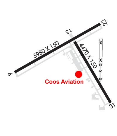
| Lat: N 4325.0 Long: W 12414.8 Elev: 17 Var: -15 Longest Runway: 5980 | ||
| AWOS: 135.07 Ground: 127.1 Tower: 118.45 | ||
| ||||||||||||||||||||||||||||||||||||||||||||
| ||||||||||||||||||||||||||||||||||||||||||||
| ||||||||||||||||||||||||||||||||||||||||||||
| Rwy | Rwy | |||||||
| 5980x150 | 5980' | 108.50 - 045° | 5980x150 | 5320' | ||||
| 4470x150 | 4470' | 4470x150 | 4470' | |||||
| Runway ID | Single Wheel | Double Wheel | Double Tandem Wheel | Dual Double Wheel |
| 05/23 | 120,000 | 215,000 | 340,000 | 800,000 |
| 13/31 | 120,000 | 190,000 | 305,000 | 735,000 |
| These numbers are Advisory and are not limits. The Airport Manager should have more accurate Weight Limits | ||||
 Airport Diagram might not be current. | |
| Facility Name: | SOUTHWEST OREGON RGNL |
| City Name: | NORTH BEND |
| County: | COOS |
| State abbrev: | OR |
| State Name: | OREGON |
| Ownership: | PUBLICLY OWNED |
| Use: | OPEN TO THE PUBLIC |
| Owner's Name: | COOS COUNTY AIRPORT DISTRICT |
| Address: | 1100 AIRPORT LANE, FLOOR 3 |
| NORTH BEND, OR 97459-2079 | |
| Owner's Phone: | 541-756-8500 |
| Manager's Name: | THERESA COOK |
| Address: | 1100 AIRPORT LANE, FLOOR 3 |
| NORTH BEND, OR 97459-2079 | |
| Phone: | 541-756-8531 |
| FAA Region: | NORTHWEST MOUNTAIN |
| FAA Field Office: | SEA |
| Date | Sunrise | Sunset |
|---|---|---|
| 09/24/21 Friday | 7:06 | 19:11 |
| 09/25/21 Saturday | 7:07 | 19:09 |
| 09/26/21 Sunday | 7:09 | 19:07 |
| 09/27/21 Monday | 7:10 | 19:05 |
| 09/28/21 Tuesday | 7:11 | 19:04 |
| 09/29/21 Wednesday | 7:12 | 19:02 |
| 09/30/21 Thursday | 7:13 | 19:00 |
| 10/01/21 Friday | 7:14 | 18:58 |
| 10/02/21 Saturday | 7:15 | 18:56 |
| 10/03/21 Sunday | 7:17 | 18:55 |
| 10/04/21 Monday | 7:18 | 18:53 |
| 10/05/21 Tuesday | 7:19 | 18:51 |
| 10/06/21 Wednesday | 7:20 | 18:49 |
| 10/07/21 Thursday | 7:21 | 18:48 |
| Airport Attendance Schedule | 7 Days A Week 0500-2100; SVC AVBL 0800-1700, FOR SVC AFTER HRS CALL (541) 756-5181 OR (541) 756-6903. |
| Airport Status | OPERATIONAL (This Status can change at any time - please check NOTAMS) |
| Airport Lighting Schedule | WHEN ATCT CLSD, ACTVT MALSR RWY 05; REIL RWYS 13, 23, 31; MIRL RWY 13/31; HIRL 05/23 - CTAF. PAPI RWY 05 OPR CONSLY. |
| Airport Storage Available | Tie Downs, Hanger |
| Extra Services Available | Air Freight, Air Ambulance, Charter, Flight Instruction, Aircraft Rental, Aircraft Sales |
| Wind Indicator | YES - (lighted) |
| Control Tower | YES |
| CTAF Frequency | 118.450 |
| Unicom Frequency | |
| Rotating Beacon Color | CLEAR-GREEN (Light Land Airport) |
| Segmented Circle | YES |
| Landing Fee | YES |
| Airport Inspected | FEDERAL - performed by FAA AIRPORTS FIELD PERSONNEL |
| Inspection Date | 12/18/2019 |
| Type of Fuel Available | Grade 100LL, JET A (freeze point -40C) |
| Airframe Repair Service | MAJOR |
| Power Plant Repair Service | MAJOR |
| Latitude | N4325.0 |
| Longitude | W12414.8 (ESTIMATED) |
| Arpt Elevation | 17ft (SURVEYED) |
| Magnetic Variation | 15E |
| 1 miles NW | of NORTH BEND |
| Traffic Pattern Altitude | |
| Sectional Chart | KLAMATH FALLS |
| Operations (Reported) | Yearly | Avg. Daily |
|---|---|---|
| General Aviation Transient | 4036 | 11 |
| General Aviation Local | 1948 | 5 |
| Air Taxi | 7058 | 19 |
| Commerical | 67 | 0 |
| Commuter | 0 | 0 |
| Military | 5440 | 15 |
| Aircraft based on Field | |
|---|---|
| General Aviation Singles | 36 |
| General Aviation Multi | 8 |
| Jet Aircraft | 1 |
| General Aviation Helicopters | 6 |
| Military Aircraft | 5 |
| Gliders | 0 |
| Ultralights | 0 |
| FSS on field | NO |
| FSS tie-in | MC MINNVILLE |
| FSS Phone | 1-800-WX-BRIEF |
| Who issues Notams | OTH |
| Notam D service at airport | YES |
| ARTCC Name | SEATTLE |
| Airport Certification | AIRPORT RECEIVING SCHEDULED AIR CARRIER SERVICE FROM CARRIERS CERTIFICATED BY THE CIVIL AERONAUTICS BOARD |
| Aircraft Rescue & Firefighting Index | AIRPORT HAS A CERTIFICATE UNDER CFR PART 139 |
| Airport of Entry | No |
| Custom Landing Rights | No |
| Joint Civil/Military | No |
| Military Landing rights | YES |
| NATIONAL PLAN OF INTEGRATED AIRPORT SYSTEMS (NPIAS) |
| GRANT AGREEMENTS UNDER FAAP/ADAP/AIP |
| SURPLUS PROPERTY AGREEMENT UNDER REGULATION 16-WAA |
| ASSURANCES PURSUANT TO TITLE VI, CIVIL RIGHTS ACT OF 1964 |
| AGREEMENT UNDER DLAND OR DCLA HAS EXPIRED. |
| SHIP CHNL XS RWY 05 APRX 2/3 MI FM THLD; XS RWY 13 & RWY 23 APRX 1000 FT TO 1700 FT FM THLD; MAST HGTS TO 144 FT. |
| MIGRATORY FLOCKS OF WATERFOWL ON & INVOF ARPT. |
| ALL ACFT SUBJECTED TO ARPT USAGE FEES. |
| PAEW INVOF RYS AND TWYS 0730-1530. |
| TWY C3 CLSD TO ACFT OVER 60,000 LBS INDEFLY. |
| FOR CD IF UNA TO CTC ON FSS FREQ, CTC SEATTLE ARTCC AT 253-351-3694. |
Airport Communications & Frequencies:
| |||||||||||
| Runway: 05 | Runway: 23 | ||
| Mag heading: | 46° | Mag heading: | 226° |
| Rwy Slope: | -.05% Down | Rwy Slope: | .05% Up |
| Approach: | ILS | Approach: | MLS |
| Pattern: | Left Traffic | Pattern: | Left Traffic |
| Markings: | PRECISION INSTRUMENT | Markings: | PRECISION INSTRUMENT |
| Marking Condition: | FAIR | Marking Condition: | FAIR |
| Arresting Dev: | Arresting Dev: | ||
| Lat & Long: | N4324.9 W12415.6 | Lat. & Long.: | N4325.4 W12414.5 |
| Elev: | 16.1 ft. MSL | Elev: | 13.4 ft. MSL |
| TCH: | 51 ft. AGL | TCH: | |
| Visual Glide Path: | 3.00 degrees | Visual Glide Path: | |
| Displaced Threshold: | No | Displaced Threshold: | 660 feet |
| Touchdown Zone: | YES | Touchdown Zone: | YES |
| Touchdown Elev.: | 16.1 feet | Touchdown Elev.: | 13.6 feet |
| Visual Glide Slope: | 4-Light PAPI on RIGHT side of Runway | Visual Glide Slope: | |
| RVR Equipment: | RVR Equipment: | ||
| RVV Equipment: | NO | RVV Equipment: | NO |
| Approach Lights: | MALSR - 1,400 foot medium intensity approach lighting system with runway alignment indicator lights | Approach Lights: | |
| REIL: | NO | REIL: | YES |
| Centerline Lights: | NO | Centerline Lights: | NO |
| Touchdown lights: | NO | Touchdown lights: | NO |
| Runway Category: | Precision Instrument Runway | Runway Category: | Runway with a Visual Approach |
| Declared Distances: | TORA:5320' TODA:5320' ASDA:5320' LDA:5320' | Declared Distances: | TORA:5980' TODA:5980' ASDA:5980' LDA:5320' |
| Obstructions: | BOAT | Obstructions: | BOAT |
| Marked: | NOT Marked/Lighted | Marked: | NOT Marked/Lighted |
| Clearance slope: | 25:1 | Clearance slope: | 8:1 |
| Obstruction height: | 144 feet AGL | Obstruction height: | 144 feet AGL |
| Dist. from runway: | 3700 feet | Dist. from runway: | 1320 feet |
| Centerline offset: | B | Centerline offset: | 550 feet right of centerline |
| Comments: | Comments: |
| Runway: 13 | Runway: 31 | ||
| Mag heading: | 135° | Mag heading: | 315° |
| Rwy Slope: | .10% Up | Rwy Slope: | -.10% Down |
| Approach: | Approach: | ||
| Pattern: | Left Traffic | Pattern: | Right Traffic |
| Markings: | BASIC | Markings: | BASIC |
| Marking Condition: | GOOD | Marking Condition: | GOOD |
| Arresting Dev: | Arresting Dev: | ||
| Lat & Long: | N4325.2 W12414.8 | Lat. & Long.: | N4324.6 W12414.3 |
| Elev: | 13.1 ft. MSL | Elev: | 17.4 ft. MSL |
| TCH: | TCH: | 50 ft. AGL | |
| Visual Glide Path: | Visual Glide Path: | 4.00 degrees | |
| Displaced Threshold: | No | Displaced Threshold: | No |
| Touchdown Zone: | YES | Touchdown Zone: | YES |
| Touchdown Elev.: | 13.6 feet | Touchdown Elev.: | 17.4 feet |
| Visual Glide Slope: | Visual Glide Slope: | 4-Light PAPI on LEFT side of Runway; P4L OTS INDEFINITELY | |
| RVR Equipment: | RVR Equipment: | ||
| RVV Equipment: | NO | RVV Equipment: | NO |
| Approach Lights: | Approach Lights: | ||
| REIL: | YES | REIL: | YES |
| Centerline Lights: | NO | Centerline Lights: | NO |
| Touchdown lights: | NO | Touchdown lights: | NO |
| Runway Category: | Runway with a Visual Approach | Runway Category: | Runway with a Visual Approach |
| Declared Distances: | TORA:4470' TODA:4470' ASDA:4470' LDA:4470' | Declared Distances: | TORA:4470' TODA:4470' ASDA:4470' LDA:4470' |
| Obstructions: | BOAT | Obstructions: | ROAD |
| Marked: | NOT Marked/Lighted | Marked: | NOT Marked/Lighted |
| Clearance slope: | 11:1 | Clearance slope: | |
| Obstruction height: | 144 feet AGL | Obstruction height: | 13 feet AGL |
| Dist. from runway: | 1740 feet | Dist. from runway: | 200 feet |
| Centerline offset: | Centerline offset: | 250 feet right of centerline | |
| Comments: | Comments: |
Thanks for using FltPlan.com
all rights reserved © 1999-2021 by Flight Plan LLC
