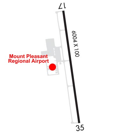
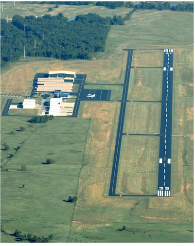
| MOUNT PLEASANT RGNL MOUNT PLEASANT TX |
| |
| Lat: N 3305.8 Long: W 09457.7 Elev: 364 Var: -04 Longest Runway: 6004 | ||
| AWOS: 119.77 CTAF: 122.7 | ||
| |||||||||||||||||||||||||||||||||||||||||||||||||||||||||||||
| |||||||||||||||||||||||||||||||||||||||||||||||||||||||||||||
| |||||||||||||||||||||||||||||||||||||||||||||||||||||||||||||
| Rwy | Rwy | |||||||
| 6004x100 | 6004' | 6004x100 | 6004' | |||||
| Runway ID | Single Wheel | Double Wheel | Double Tandem Wheel | Dual Double Wheel |
| 17/35 | 30,000 | N/A | N/A | N/A |
| H1 | N/A | N/A | N/A | N/A |
| These numbers are Advisory and are not limits. The Airport Manager should have more accurate Weight Limits | ||||
 Airport Diagram might not be current. | |
| Facility Name: | MOUNT PLEASANT RGNL |
| City Name: | MOUNT PLEASANT |
| County: | TITUS |
| State abbrev: | TX |
| State Name: | TEXAS |
| Ownership: | PUBLICLY OWNED |
| Use: | OPEN TO THE PUBLIC |
| Owner's Name: | CITY OF MOUNT PLEASANT |
| Address: | 501 NORTH MADISON |
| MOUNT PLEASANT, TX 75455 | |
| Owner's Phone: | 903-575-4000 |
| Manager's Name: | PAUL HENDERSON |
| Address: | 501 MIKE HALL PARKWAY |
| MOUNT PLEASANT, TX 75455 | |
| Phone: | 903-575-4020; PHENDERSON@MPCITY.ORG |
| FAA Region: | SOUTHWEST |
| FAA Field Office: | TEX |
| Date | Sunrise | Sunset |
|---|---|---|
| 06/07/26 Sunday | 6:11 | 20:27 |
| 06/08/26 Monday | 6:11 | 20:27 |
| 06/09/26 Tuesday | 6:10 | 20:28 |
| 06/10/26 Wednesday | 6:10 | 20:28 |
| 06/11/26 Thursday | 6:10 | 20:29 |
| 06/12/26 Friday | 6:10 | 20:29 |
| 06/13/26 Saturday | 6:10 | 20:29 |
| 06/14/26 Sunday | 6:10 | 20:30 |
| 06/15/26 Monday | 6:10 | 20:30 |
| 06/16/26 Tuesday | 6:11 | 20:31 |
| 06/17/26 Wednesday | 6:11 | 20:31 |
| 06/18/26 Thursday | 6:11 | 20:31 |
| 06/19/26 Friday | 6:11 | 20:31 |
| 06/20/26 Saturday | 6:11 | 20:32 |
| Airport Attendance Schedule | 7 Days A Week 0700-1800 |
| Airport Status | OPERATIONAL (This Status can change at any time - please check NOTAMS) |
| Airport Lighting Schedule | REIL RWY 17 & 35, MIRL RWY 17/35 PRE-SET ON LOW SS-SR. TO ACTVT DAYTIME & INCR INTST - CTAF. PAPI RWY 17 & 35 OPR CONSLY. |
| Airport Storage Available | Tie Downs, Hanger |
| Extra Services Available | NONE |
| Wind Indicator | YES - (lighted) |
| Control Tower | NO |
| CTAF Frequency | 122.700 |
| Unicom Frequency | 122.700 |
| Rotating Beacon Color | WG |
| Segmented Circle | YES |
| Landing Fee |
| Airport Inspected | CONTRACTOR - performed by PRIVATE CONTRACT PERSONNEL |
| Inspection Date | 05/13/2024 |
| Type of Fuel Available | Grade 100LL, JET A (freeze point -40C); -10FOR JET A AFT HRS CALL 903-575-4004. 100LL AVBL 24 HRS SELF SERV. |
| Airframe Repair Service | MAJOR |
| Power Plant Repair Service | MAJOR |
| Latitude | N3305.8 |
| Longitude | W09457.7 (ESTIMATED) |
| Arpt Elevation | 364ft (SURVEYED) |
| Magnetic Variation | 04E |
| 3 miles S | of MOUNT PLEASANT |
| Traffic Pattern Altitude | |
| Sectional Chart | MEMPHIS |
| Operations (Reported) | Yearly | Avg. Daily |
|---|---|---|
| General Aviation Transient | 0 | 0 |
| General Aviation Local | 0 | 0 |
| Air Taxi | 0 | 0 |
| Commerical | 0 | 0 |
| Commuter | 0 | 0 |
| Military | 0 | 0 |
| Aircraft based on Field | |
|---|---|
| General Aviation Singles | 0 |
| General Aviation Multi | 0 |
| Jet Aircraft | 0 |
| General Aviation Helicopters | 0 |
| Military Aircraft | 0 |
| Gliders | 0 |
| Ultralights | 0 |
| FSS on field | NO |
| FSS tie-in | FORT WORTH |
| FSS Phone | 1-800-WX-BRIEF |
| Who issues Notams | OSA |
| Notam D service at airport | YES |
| ARTCC Name | FORT WORTH |
| Airport Certification | |
| Aircraft Rescue & Firefighting Index | None |
| Airport of Entry | No |
| Custom Landing Rights | No |
| Joint Civil/Military | No |
| Military Landing rights | No |
| NATIONAL PLAN OF INTEGRATED AIRPORT SYSTEMS (NPIAS) |
| GRANT AGREEMENTS UNDER FAAP/ADAP/AIP |
| DEER & WILDLIFE ON & INVOF ARPT. |
| NO LINE OF SIGHT BETWEEN RWY ENDS. |
| FOR CD CTC FORT WORTH ARTCC AT 817-858-7584. |
Airport Communications & Frequencies:
| |||||||||
| Runway: 17 | Runway: 35 | ||
| Mag heading: | 168° | Mag heading: | 348° |
| Rwy Slope: | -.38% Down | Rwy Slope: | .38% Up |
| Approach: | Approach: | ||
| Pattern: | Left Traffic | Pattern: | Left Traffic |
| Markings: | NONPRECISION INSTRUMENT | Markings: | NONPRECISION INSTRUMENT |
| Marking Condition: | POOR; MKGS DISCOLORED. | Marking Condition: | POOR; MKGS DISCOLORED. |
| Arresting Dev: | Arresting Dev: | ||
| Lat & Long: | N3306.3 W09457.8 | Lat. & Long.: | N3305.3 W09457.6 |
| Elev: | 364.2 ft. MSL | Elev: | 341.5 ft. MSL |
| TCH: | 40 ft. AGL | TCH: | 45 ft. AGL |
| Visual Glide Path: | 3.00 degrees | Visual Glide Path: | 3.00 degrees |
| Displaced Threshold: | No | Displaced Threshold: | No |
| Touchdown Zone: | YES | Touchdown Zone: | YES |
| Touchdown Elev.: | 364.2 feet | Touchdown Elev.: | 359.6 feet |
| Visual Glide Slope: | 4-Light PAPI on LEFT side of Runway | Visual Glide Slope: | 4-Light PAPI on LEFT side of Runway |
| RVR Equipment: | RVR Equipment: | ||
| RVV Equipment: | NO | RVV Equipment: | NO |
| Approach Lights: | Approach Lights: | ||
| REIL: | YES | REIL: | YES |
| Centerline Lights: | NO | Centerline Lights: | NO |
| Touchdown lights: | NO | Touchdown lights: | NO |
| Runway Category: | Runway with a Non-precision Approach having visibility minimums greater than 3/4 mile | Runway Category: | Runway with a Non-precision Approach having visibility minimums greater than 3/4 mile |
| Declared Distances: | Declared Distances: | ||
| Obstructions: | Obstructions: | TREES | |
| Marked: | Marked: | NOT Marked/Lighted | |
| Clearance slope: | 50:1 | Clearance slope: | 26:1 |
| Obstruction height: | Obstruction height: | 80 feet AGL | |
| Dist. from runway: | Dist. from runway: | 2300 feet | |
| Centerline offset: | Centerline offset: | 30 feet right of centerline | |
| Comments: | Comments: |
Thanks for using FltPlan.com
all rights reserved © 1999-2026 by Flight Plan LLC