| NORTH LITTLE ROCK MUNI NORTH LITTLE ROCK AR |
| |
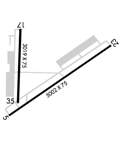
| Lat: N 3450.0 Long: W 09215.2 Elev: 545 Var: -02 Longest Runway: 5002 | ||
| Clr Del: 121.6 CTAF: 123.07 | ||
| |||||||||||||||||||||||
| |||||||||||||||||||||||
| |||||||||||||||||||||||
| Rwy | Rwy | |||||||
| 5002x75 | 5002' | 111.90 - 053° | 5002x75 | 5002' | ||||
| 3019x75 | 3019' | 3019x75 | 3019' | |||||
| Runway ID | Single Wheel | Double Wheel | Double Tandem Wheel | Dual Double Wheel |
| 05/23 | 30,000 | 60,000 | N/A | N/A |
| 17/35 | 17,000 | N/A | N/A | N/A |
| These numbers are Advisory and are not limits. The Airport Manager should have more accurate Weight Limits | ||||
 Airport Diagram might not be current. | |
| Facility Name: | NORTH LITTLE ROCK MUNI |
| City Name: | NORTH LITTLE ROCK |
| County: | PULASKI |
| State abbrev: | AR |
| State Name: | ARKANSAS |
| Ownership: | PUBLICLY OWNED |
| Use: | OPEN TO THE PUBLIC |
| Owner's Name: | CITY OF NORTH LITTLE ROCK |
| Address: | PO BOX 5757 |
| NORTH LITTLE ROCK, AR 72119 | |
| Owner's Phone: | 501-340-5302 |
| Manager's Name: | CLAY ROGERS |
| Address: | 8202 REMOUNT ROAD |
| NORTH LITTLE ROCK, AR 72118 | |
| Phone: | 501-835-5654 |
| FAA Region: | SOUTHWEST |
| FAA Field Office: | AOK |
| Date | Sunrise | Sunset |
|---|---|---|
| 09/24/21 Friday | 6:58 | 19:03 |
| 09/25/21 Saturday | 6:59 | 19:02 |
| 09/26/21 Sunday | 7:00 | 19:00 |
| 09/27/21 Monday | 7:01 | 18:59 |
| 09/28/21 Tuesday | 7:01 | 18:58 |
| 09/29/21 Wednesday | 7:02 | 18:56 |
| 09/30/21 Thursday | 7:03 | 18:55 |
| 10/01/21 Friday | 7:04 | 18:53 |
| 10/02/21 Saturday | 7:04 | 18:52 |
| 10/03/21 Sunday | 7:05 | 18:51 |
| 10/04/21 Monday | 7:06 | 18:49 |
| 10/05/21 Tuesday | 7:07 | 18:48 |
| 10/06/21 Wednesday | 7:07 | 18:46 |
| 10/07/21 Thursday | 7:08 | 18:45 |
| Airport Attendance Schedule | 7 Days A Week 0800-DUSK |
| Airport Status | OPERATIONAL (This Status can change at any time - please check NOTAMS) |
| Airport Lighting Schedule | ACTVT MIRL RYS 05/23 & 17/35; REIL RYS 05, 23 & 17 - CTAF. PAPI RYS 05, 23, 17 & 35 OPERATES CONTINUOUSLY. |
| Airport Storage Available | Tie Downs |
| Extra Services Available | Charter, Flight Instruction, Aircraft Rental, Aircraft Sales |
| Wind Indicator | YES - (lighted) |
| Control Tower | NO |
| CTAF Frequency | 123.075 |
| Unicom Frequency | 123.075 |
| Rotating Beacon Color | CLEAR-GREEN (Light Land Airport) |
| Segmented Circle | YES |
| Landing Fee | NO |
| Airport Inspected | STATE - performed by STATE AERONAUTICAL PERSONNEL |
| Inspection Date | 06/25/2021 |
| Type of Fuel Available | Grade 100LL, JET A (freeze point -40C); -10100LL AVBL 24 HR SELF SERVICE WITH CREDIT CARD. |
| Airframe Repair Service | MAJOR |
| Power Plant Repair Service | MAJOR |
| Latitude | N3450.0 |
| Longitude | W09215.2 (ESTIMATED) |
| Arpt Elevation | 545ft (SURVEYED) |
| Magnetic Variation | 02E |
| 4 miles N | of NORTH LITTLE ROCK |
| Traffic Pattern Altitude | 1000; TPA FOR HELS 500 FT AGL, PROP ACFT 1000 FT AGL, TURBOPROP ACFT 1500 FT AGL |
| Sectional Chart | MEMPHIS |
| Operations (Reported) | Yearly | Avg. Daily |
|---|---|---|
| General Aviation Transient | 6000 | 16 |
| General Aviation Local | 25000 | 68 |
| Air Taxi | 1000 | 3 |
| Commerical | 0 | 0 |
| Commuter | 0 | 0 |
| Military | 200 | 1 |
| Aircraft based on Field | |
|---|---|
| General Aviation Singles | 50 |
| General Aviation Multi | 4 |
| Jet Aircraft | 3 |
| General Aviation Helicopters | 4 |
| Military Aircraft | 0 |
| Gliders | 0 |
| Ultralights | 0 |
| FSS on field | NO |
| FSS tie-in | JONESBORO |
| FSS Phone | 1-800-WX-BRIEF |
| Who issues Notams | JBR |
| Notam D service at airport | YES |
| ARTCC Name | MEMPHIS |
| Airport Certification | |
| Aircraft Rescue & Firefighting Index | None |
| Airport of Entry | No |
| Custom Landing Rights | No |
| Joint Civil/Military | No |
| Military Landing rights | YES |
| NATIONAL PLAN OF INTEGRATED AIRPORT SYSTEMS (NPIAS) |
| GRANT AGREEMENTS UNDER FAAP/ADAP/AIP |
| CONVEYANCE UNDER SCETION 16, FEDERAL AIRPORT ACT OF 1946 OR SECTION 23, AIRPORT AND AIRWAY DEVELOPMENT ACT OF 1970 |
| ASSURANCES PURSUANT TO TITLE VI, CIVIL RIGHTS ACT OF 1964 |
| FOR CD WHEN UNA VIA FREQ CTC LITTLE ROCK APCH 501-379-2908 OR LITTLE ROCK ATCT 501-379-2911 |
| RY 23 THLD NOT VISIBLE FM RY 17 THLD. |
| DEER ON & INVOF ARPT. |
| RY 17/35 500 FT BLAST PAD NORTH END. |
| FOR ARPT ACCESS CALL 501-835-5654; 501-529-1051 |
| ULTRALIGHT ACTIVITY ON & INVOF ARPT. |
Airport Communications & Frequencies:
| ||||||||||||||||
| Runway: 05 | Runway: 23 | ||
| Mag heading: | 53° | Mag heading: | 233° |
| Rwy Slope: | -.46% Down | Rwy Slope: | .46% Up |
| Approach: | LOC/DME | Approach: | |
| Pattern: | Left Traffic | Pattern: | Right Traffic |
| Markings: | PRECISION INSTRUMENT | Markings: | NONPRECISION INSTRUMENT |
| Marking Condition: | GOOD | Marking Condition: | GOOD |
| Arresting Dev: | Arresting Dev: | ||
| Lat & Long: | N3449.7 W09215.5 | Lat. & Long.: | N3450.2 W09214.7 |
| Elev: | 541.2 ft. MSL | Elev: | 518.0 ft. MSL |
| TCH: | 49 ft. AGL | TCH: | 43 ft. AGL |
| Visual Glide Path: | 3.00 degrees | Visual Glide Path: | 3.00 degrees |
| Displaced Threshold: | No | Displaced Threshold: | No |
| Touchdown Zone: | YES | Touchdown Zone: | YES |
| Touchdown Elev.: | 541.3 feet | Touchdown Elev.: | 537.0 feet |
| Visual Glide Slope: | 2-Light PAPI on RIGHT side of Runway | Visual Glide Slope: | 2-Light PAPI on LEFT side of Runway |
| RVR Equipment: | RVR Equipment: | ||
| RVV Equipment: | NO | RVV Equipment: | NO |
| Approach Lights: | Approach Lights: | ||
| REIL: | YES | REIL: | YES |
| Centerline Lights: | NO | Centerline Lights: | NO |
| Touchdown lights: | NO | Touchdown lights: | NO |
| Runway Category: | Runway with a Non-precision Approach having visibility minimums greater than 3/4 mile | Runway Category: | Runway with a Visual Approach |
| Declared Distances: | Declared Distances: | ||
| Obstructions: | TREES | Obstructions: | TREES |
| Marked: | NOT Marked/Lighted | Marked: | NOT Marked/Lighted |
| Clearance slope: | 46:1 | Clearance slope: | 36:1 |
| Obstruction height: | 16 feet AGL | Obstruction height: | 18 feet AGL |
| Dist. from runway: | 950 feet | Dist. from runway: | 850 feet |
| Centerline offset: | 100 right of centerline | Centerline offset: | 300 feet left of centerline |
| Comments: | Comments: |
| Runway: 17 | Runway: 35 | ||
| Mag heading: | 178° | Mag heading: | 358° |
| Rwy Slope: | -.10% Down | Rwy Slope: | .10% Up |
| Approach: | Approach: | ||
| Pattern: | Right Traffic | Pattern: | Left Traffic; CALM WIND PREFERRED TKOF/LNDG TO THE NORTH WHEN POSSIBLE. |
| Markings: | NONPRECISION INSTRUMENT | Markings: | NONPRECISION INSTRUMENT |
| Marking Condition: | FAIR | Marking Condition: | FAIR |
| Arresting Dev: | Arresting Dev: | ||
| Lat & Long: | N3450.3 W09215.4 | Lat. & Long.: | N3449.8 W09215.4 |
| Elev: | 544.1 ft. MSL | Elev: | 541.1 ft. MSL |
| TCH: | 44 ft. AGL | TCH: | 44 ft. AGL |
| Visual Glide Path: | 3.00 degrees | Visual Glide Path: | 3.00 degrees |
| Displaced Threshold: | No | Displaced Threshold: | No |
| Touchdown Zone: | YES | Touchdown Zone: | YES |
| Touchdown Elev.: | 545.4 feet | Touchdown Elev.: | 545.4 feet |
| Visual Glide Slope: | 2-Light PAPI on LEFT side of Runway | Visual Glide Slope: | 2-Light PAPI on LEFT side of Runway |
| RVR Equipment: | RVR Equipment: | ||
| RVV Equipment: | NO | RVV Equipment: | NO |
| Approach Lights: | Approach Lights: | ||
| REIL: | YES | REIL: | NO |
| Centerline Lights: | NO | Centerline Lights: | NO |
| Touchdown lights: | NO | Touchdown lights: | NO |
| Runway Category: | Runway with a Visual Approach | Runway Category: | Runway with a Non-precision Approach |
| Declared Distances: | Declared Distances: | ||
| Obstructions: | GND | Obstructions: | TREES |
| Marked: | NOT Marked/Lighted | Marked: | NOT Marked/Lighted |
| Clearance slope: | Clearance slope: | 34:1 | |
| Obstruction height: | 12 feet AGL | Obstruction height: | 26 feet AGL |
| Dist. from runway: | 200 feet | Dist. from runway: | 1100 feet |
| Centerline offset: | 200 left of centerline | Centerline offset: | |
| Comments: | +12 FT BERM 100 FT FM RY END 200 FT L & R OF CNTRLN EXTENDED INTO PRIMARY SFC. | Comments: |
Thanks for using FltPlan.com
all rights reserved © 1999-2021 by Flight Plan LLC