
| ORANGE COUNTY ORANGE TX |
| |
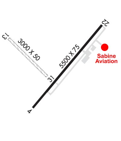
| Lat: N 3004.1 Long: W 09348.2 Elev: 13 Var: -02 Longest Runway: 5500 | ||
| AWOS: 118.97 CTAF: 122.8 | ||
| ||||||
| ||||||
|
| Rwy | Rwy | |||||||
| 5500x75 | 5500' | 5500x75 | 5500' | |||||
| 3000x50 | 3000' | 3000x50 | 3000' | |||||
| Runway ID | Single Wheel | Double Wheel | Double Tandem Wheel | Dual Double Wheel |
| 04/22 | 27,000 | N/A | N/A | N/A |
| 13/31 | N/A | N/A | N/A | N/A |
| These numbers are Advisory and are not limits. The Airport Manager should have more accurate Weight Limits | ||||
 Airport Diagram might not be current. | |
| Facility Name: | ORANGE COUNTY |
| City Name: | ORANGE |
| County: | ORANGE |
| State abbrev: | TX |
| State Name: | TEXAS |
| Ownership: | PUBLICLY OWNED |
| Use: | OPEN TO THE PUBLIC |
| Owner's Name: | ORANGE COUNTY; TURF RWY LEASED. |
| Address: | 123 S. 6TH STREET |
| ORANGE, TX 77630 | |
| Owner's Phone: | (409) 882-7070 |
| Manager's Name: | MISSY PILLSBURY |
| Address: | 2640 S. HWY 87 |
| ORANGE, TX 77630 | |
| Phone: | (409) 882-7861 |
| FAA Region: | SOUTHWEST |
| FAA Field Office: | TEX |
| Date | Sunrise | Sunset |
|---|---|---|
| 09/24/21 Friday | 7:05 | 19:10 |
| 09/25/21 Saturday | 7:05 | 19:08 |
| 09/26/21 Sunday | 7:06 | 19:07 |
| 09/27/21 Monday | 7:06 | 19:06 |
| 09/28/21 Tuesday | 7:07 | 19:05 |
| 09/29/21 Wednesday | 7:07 | 19:03 |
| 09/30/21 Thursday | 7:08 | 19:02 |
| 10/01/21 Friday | 7:08 | 19:01 |
| 10/02/21 Saturday | 7:09 | 19:00 |
| 10/03/21 Sunday | 7:10 | 18:58 |
| 10/04/21 Monday | 7:10 | 18:57 |
| 10/05/21 Tuesday | 7:11 | 18:56 |
| 10/06/21 Wednesday | 7:11 | 18:55 |
| 10/07/21 Thursday | 7:12 | 18:54 |
| Airport Attendance Schedule | 7 Days A Week 0700-1700 |
| Airport Status | OPERATIONAL (This Status can change at any time - please check NOTAMS) |
| Airport Lighting Schedule | MIRL RWY 04/22 PRESET LOW INTST; TO INCR INTST & ACTVT REIL RWY 4 & 22 - CTAF.; SS-SR |
| Airport Storage Available | Tie Downs |
| Extra Services Available | NONE |
| Wind Indicator | YES - (lighted) |
| Control Tower | NO |
| CTAF Frequency | 122.800 |
| Unicom Frequency | 122.800 |
| Rotating Beacon Color | CLEAR-GREEN (Light Land Airport) |
| Segmented Circle | YES |
| Landing Fee | NO |
| Airport Inspected | STATE - performed by PRIVATE CONTRACT PERSONNEL |
| Inspection Date | 04/21/2020 |
| Type of Fuel Available | Grade 100LL, JET A (freeze point -40C) |
| Airframe Repair Service | MAJOR |
| Power Plant Repair Service | MAJOR |
| Latitude | N3004.1 |
| Longitude | W09348.2 (ESTIMATED) |
| Arpt Elevation | 13ft (SURVEYED) |
| Magnetic Variation | 02E |
| 3 miles SW | of ORANGE |
| Traffic Pattern Altitude | |
| Sectional Chart | HOUSTON |
| Operations (Reported) | Yearly | Avg. Daily |
|---|---|---|
| General Aviation Transient | 3020 | 8 |
| General Aviation Local | 8600 | 24 |
| Air Taxi | 850 | 2 |
| Commerical | 0 | 0 |
| Commuter | 0 | 0 |
| Military | 0 | 0 |
| Aircraft based on Field | |
|---|---|
| General Aviation Singles | 19 |
| General Aviation Multi | 2 |
| Jet Aircraft | 0 |
| General Aviation Helicopters | 1 |
| Military Aircraft | 0 |
| Gliders | 0 |
| Ultralights | 0 |
| FSS on field | NO |
| FSS tie-in | MONTGOMERY COUNTY |
| FSS Phone | 1-800-WX-BRIEF |
| Who issues Notams | ORG |
| Notam D service at airport | YES |
| ARTCC Name | HOUSTON |
| Airport Certification | |
| Aircraft Rescue & Firefighting Index | None |
| Airport of Entry | No |
| Custom Landing Rights | No |
| Joint Civil/Military | No |
| Military Landing rights | YES |
| NATIONAL PLAN OF INTEGRATED AIRPORT SYSTEMS (NPIAS) |
| GRANT AGREEMENTS UNDER FAAP/ADAP/AIP |
| SURPLUS PROPERTY AGREEMENT UNDER PUBLIC LAW 289 |
| ASSURANCES PURSUANT TO TITLE VI, CIVIL RIGHTS ACT OF 1964 |
| TREES OBSTRUCT PRIMARY SFC RWY 13/31. |
| 3 FT OPEN DRAINAGE CULVERT AT THR, 31 FT BOTH SIDES. |
| FOR CD CTC HOUSTON APCH AT 281-443-5844 TO CNL IFR CALL 281-443-5888. |
| RWY 13/3 1 RWY NOT MNTND, RWY SFC ROUGH, DEEP RUTS, NOT SUITABLE FOR ACFT. CLSD INDEFLY. |
Airport Communications & Frequencies:
| ||||||||||||||
| Runway: 04 | Runway: 22 | ||
| Mag heading: | 40° | Mag heading: | 220° |
| Rwy Slope: | .04% Up | Rwy Slope: | -.04% Down |
| Approach: | Approach: | ||
| Pattern: | Left Traffic | Pattern: | Left Traffic |
| Markings: | NONPRECISION INSTRUMENT | Markings: | NONPRECISION INSTRUMENT |
| Marking Condition: | GOOD | Marking Condition: | GOOD |
| Arresting Dev: | Arresting Dev: | ||
| Lat & Long: | N3003.7 W09348.5 | Lat. & Long.: | N3004.4 W09347.8 |
| Elev: | 10.3 ft. MSL | Elev: | 12.3 ft. MSL |
| TCH: | 22 ft. AGL | TCH: | 21 ft. AGL |
| Visual Glide Path: | 3.00 degrees | Visual Glide Path: | 3.00 degrees |
| Displaced Threshold: | No | Displaced Threshold: | No |
| Touchdown Zone: | YES | Touchdown Zone: | YES |
| Touchdown Elev.: | 10.3 feet | Touchdown Elev.: | 13.2 feet |
| Visual Glide Slope: | 2-Light PAPI on LEFT side of Runway | Visual Glide Slope: | 2-Light PAPI on LEFT side of Runway |
| RVR Equipment: | RVR Equipment: | ||
| RVV Equipment: | NO | RVV Equipment: | NO |
| Approach Lights: | Approach Lights: | ||
| REIL: | YES | REIL: | YES |
| Centerline Lights: | NO | Centerline Lights: | NO |
| Touchdown lights: | NO | Touchdown lights: | NO |
| Runway Category: | Runway with a Visual Approach | Runway Category: | Runway with a Non-precision Approach having visibility minimums greater than 3/4 mile |
| Declared Distances: | Declared Distances: | ||
| Obstructions: | TREES | Obstructions: | TREES |
| Marked: | NOT Marked/Lighted | Marked: | NOT Marked/Lighted |
| Clearance slope: | 6:1 | Clearance slope: | 14:1 |
| Obstruction height: | 30 feet AGL | Obstruction height: | 55 feet AGL |
| Dist. from runway: | 394 feet | Dist. from runway: | 1000 feet |
| Centerline offset: | 80 left of centerline | Centerline offset: | 180 feet right of centerline |
| Comments: | Comments: |
| Runway: 13 | Runway: 31 | ||
| Mag heading: | 135° | Mag heading: | 315° |
| Rwy Slope: | .00% | Rwy Slope: | .00% |
| Approach: | Approach: | ||
| Pattern: | Left Traffic | Pattern: | Left Traffic |
| Markings: | Markings: | ||
| Marking Condition: | RWY 13/31 MARKED WITH WHITE TIRES. | Marking Condition: | |
| Arresting Dev: | Arresting Dev: | ||
| Lat & Long: | N3004.3 W09348.6 | Lat. & Long.: | N3004.0 W09348.3 |
| Elev: | 10.0 ft. MSL | Elev: | 10.0 ft. MSL |
| TCH: | TCH: | ||
| Visual Glide Path: | Visual Glide Path: | ||
| Displaced Threshold: | No | Displaced Threshold: | No |
| Touchdown Zone: | YES | Touchdown Zone: | YES |
| Touchdown Elev.: | 10.0 feet | Touchdown Elev.: | 10.0 feet |
| Visual Glide Slope: | Visual Glide Slope: | ||
| RVR Equipment: | RVR Equipment: | ||
| RVV Equipment: | NO | RVV Equipment: | NO |
| Approach Lights: | Approach Lights: | ||
| REIL: | NO | REIL: | NO |
| Centerline Lights: | NO | Centerline Lights: | NO |
| Touchdown lights: | NO | Touchdown lights: | NO |
| Runway Category: | Runway with a Visual Approach | Runway Category: | Runway with a Visual Approach |
| Declared Distances: | Declared Distances: | ||
| Obstructions: | TREE | Obstructions: | TREES |
| Marked: | NOT Marked/Lighted | Marked: | NOT Marked/Lighted |
| Clearance slope: | Clearance slope: | 13:1 | |
| Obstruction height: | 30 feet AGL | Obstruction height: | 60 feet AGL |
| Dist. from runway: | 0 feet | Dist. from runway: | 800 feet |
| Centerline offset: | 50 left of centerline | Centerline offset: | |
| Comments: | Comments: |
Thanks for using FltPlan.com
all rights reserved © 1999-2021 by Flight Plan LLC
