
| ORANGE MUNI ORANGE MA |
| |
| Lat: N 4234.2 Long: W 07217.3 Elev: 556 Var: +15 Longest Runway: 5001 | ||
| AWOS: 135.67 CTAF: 122.8 | ||
| ||||||||||||||||||||||||||||||||||||||||||||
| ||||||||||||||||||||||||||||||||||||||||||||
| ||||||||||||||||||||||||||||||||||||||||||||
| Rwy | Rwy | |||||||
| 5001x75 | 4900' | 5001x75 | 4201' | |||||
| 4800x75 | 4800' | 4800x75 | 3510' | |||||
| Runway ID | Single Wheel | Double Wheel | Double Tandem Wheel | Dual Double Wheel |
| 01/19 | 25,000 | N/A | N/A | N/A |
| 14/32 | 25,000 | N/A | N/A | N/A |
| These numbers are Advisory and are not limits. The Airport Manager should have more accurate Weight Limits | ||||
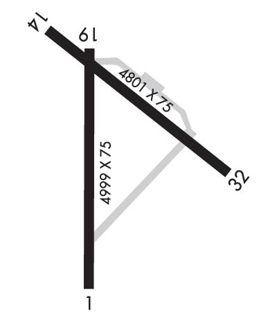 Airport Diagram might not be current. | |
| Facility Name: | ORANGE MUNI |
| City Name: | ORANGE |
| County: | FRANKLIN |
| State abbrev: | MA |
| State Name: | MASSACHUSETTS |
| Ownership: | PUBLICLY OWNED |
| Use: | OPEN TO THE PUBLIC |
| Owner's Name: | TOWN OF ORANGE |
| Address: | 6 PROSPECT ST |
| ORANGE, MA 01364 | |
| Owner's Phone: | 978-544-1100 |
| Manager's Name: | LEONARD BEDAW |
| Address: | 80 AIRPORT STREET |
| ORANGE, MA 01364 | |
| Phone: | 978-544-8189 |
| FAA Region: | NEW ENGLAND |
| FAA Field Office: | NONE |
| Date | Sunrise | Sunset |
|---|---|---|
| 09/24/21 Friday | 6:38 | 18:43 |
| 09/25/21 Saturday | 6:39 | 18:42 |
| 09/26/21 Sunday | 6:40 | 18:40 |
| 09/27/21 Monday | 6:42 | 18:38 |
| 09/28/21 Tuesday | 6:43 | 18:36 |
| 09/29/21 Wednesday | 6:44 | 18:35 |
| 09/30/21 Thursday | 6:45 | 18:33 |
| 10/01/21 Friday | 6:46 | 18:31 |
| 10/02/21 Saturday | 6:47 | 18:29 |
| 10/03/21 Sunday | 6:48 | 18:28 |
| 10/04/21 Monday | 6:49 | 18:26 |
| 10/05/21 Tuesday | 6:50 | 18:24 |
| 10/06/21 Wednesday | 6:52 | 18:22 |
| 10/07/21 Thursday | 6:53 | 18:21 |
| Airport Attendance Schedule | 7 Days A Week 0800-1700 |
| Airport Status | OPERATIONAL (This Status can change at any time - please check NOTAMS) |
| Airport Lighting Schedule | DUSK-DAWN. ACTVT MIRL RWYS 01/19 & 14/32 - CTAF. |
| Airport Storage Available | Tie Downs |
| Extra Services Available | Charter, Flight Instruction, Parachute Jumping, Aircraft Rental, Aircraft Sales |
| Wind Indicator | YES - (unlit) |
| Control Tower | NO |
| CTAF Frequency | 122.800 |
| Unicom Frequency | 122.800 |
| Rotating Beacon Color | CLEAR-GREEN (Light Land Airport) |
| Segmented Circle | YES |
| Landing Fee | NO |
| Airport Inspected | STATE - performed by STATE AERONAUTICAL PERSONNEL |
| Inspection Date | 08/11/2020 |
| Type of Fuel Available | Grade 100LL, JET A (freeze point -40C); -10100LL FUEL SELF-SVC AVBL 24 HRS. AFT HRS EMERG/FUEL PHONE CTC 978-894-3264. |
| Airframe Repair Service | MAJOR |
| Power Plant Repair Service | MAJOR |
| Latitude | N4234.2 |
| Longitude | W07217.3 (ESTIMATED) |
| Arpt Elevation | 555ft (SURVEYED) |
| Magnetic Variation | 15W |
| 1 miles SE | of ORANGE |
| Traffic Pattern Altitude | |
| Sectional Chart | NEW YORK |
| Operations (Reported) | Yearly | Avg. Daily |
|---|---|---|
| General Aviation Transient | 15500 | 42 |
| General Aviation Local | 8500 | 23 |
| Air Taxi | 10500 | 29 |
| Commerical | 0 | 0 |
| Commuter | 0 | 0 |
| Military | 50 | 0 |
| Aircraft based on Field | |
|---|---|
| General Aviation Singles | 38 |
| General Aviation Multi | 2 |
| Jet Aircraft | 0 |
| General Aviation Helicopters | 0 |
| Military Aircraft | 0 |
| Gliders | 0 |
| Ultralights | 1 |
| FSS on field | NO |
| FSS tie-in | BRIDGEPORT |
| FSS Phone | 1-800-WX-BRIEF |
| Who issues Notams | ORE |
| Notam D service at airport | YES |
| ARTCC Name | BOSTON |
| Airport Certification | |
| Aircraft Rescue & Firefighting Index | None |
| Airport of Entry | No |
| Custom Landing Rights | No |
| Joint Civil/Military | No |
| Military Landing rights | YES |
| NATIONAL PLAN OF INTEGRATED AIRPORT SYSTEMS (NPIAS) |
| GRANT AGREEMENTS UNDER FAAP/ADAP/AIP |
| ASSURANCES PURSUANT TO TITLE VI, CIVIL RIGHTS ACT OF 1964 |
| AGREEMENT UNDER DLAND OR DCLA HAS EXPIRED. |
| PAJA WI 2 NM OF AIRFIELD, SFC TO 14500 FT MSL, 7 DAYS A WEEK, SR-SS, APR 1-NOV 30. |
| WILDLIFE ON AND INVOF ARPT. |
| FOR CD CTC BOSTON ARTCC AT 603-879-6859. |
Airport Communications & Frequencies:
| |||||||||
| Runway: 01 | Runway: 19 | ||
| Mag heading: | 16° | Mag heading: | 196° |
| Rwy Slope: | -.43% Down | Rwy Slope: | .43% Up |
| Approach: | Approach: | ||
| Pattern: | Left Traffic | Pattern: | Left Traffic |
| Markings: | BASIC | Markings: | BASIC |
| Marking Condition: | GOOD | Marking Condition: | GOOD |
| Arresting Dev: | Arresting Dev: | ||
| Lat & Long: | N4233.7 W07217.4 | Lat. & Long.: | N4234.5 W07217.4 |
| Elev: | 555.6 ft. MSL | Elev: | 533.9 ft. MSL |
| TCH: | TCH: | ||
| Visual Glide Path: | Visual Glide Path: | ||
| Displaced Threshold: | 101 feet | Displaced Threshold: | 800 feet |
| Touchdown Zone: | YES | Touchdown Zone: | YES |
| Touchdown Elev.: | 555.4 feet | Touchdown Elev.: | 551.8 feet |
| Visual Glide Slope: | Visual Glide Slope: | ||
| RVR Equipment: | RVR Equipment: | ||
| RVV Equipment: | NO | RVV Equipment: | NO |
| Approach Lights: | Approach Lights: | ||
| REIL: | NO | REIL: | NO |
| Centerline Lights: | NO | Centerline Lights: | NO |
| Touchdown lights: | NO | Touchdown lights: | NO |
| Runway Category: | Runway with a Visual Approach | Runway Category: | Runway with a Visual Approach |
| Declared Distances: | Declared Distances: | ||
| Obstructions: | TREES | Obstructions: | TREES |
| Marked: | NOT Marked/Lighted | Marked: | NOT Marked/Lighted |
| Clearance slope: | 20:1 | Clearance slope: | 20:1 |
| Obstruction height: | 50 feet AGL | Obstruction height: | 30 feet AGL |
| Dist. from runway: | 1200 feet | Dist. from runway: | 800 feet |
| Centerline offset: | 125 right of centerline | Centerline offset: | 135 feet right of centerline |
| Comments: | Comments: |
| Runway: 14 | Runway: 32 | ||
| Mag heading: | 142° | Mag heading: | 322° |
| Rwy Slope: | .38% Up | Rwy Slope: | -.38% Down |
| Approach: | Approach: | ||
| Pattern: | Left Traffic | Pattern: | Left Traffic |
| Markings: | NONPRECISION INSTRUMENT | Markings: | NONPRECISION INSTRUMENT |
| Marking Condition: | FAIR | Marking Condition: | FAIR |
| Arresting Dev: | Arresting Dev: | ||
| Lat & Long: | N4234.6 W07217.6 | Lat. & Long.: | N4234.1 W07216.8 |
| Elev: | 533.3 ft. MSL | Elev: | 551.5 ft. MSL |
| TCH: | TCH: | ||
| Visual Glide Path: | Visual Glide Path: | ||
| Displaced Threshold: | No | Displaced Threshold: | 1290 feet |
| Touchdown Zone: | YES | Touchdown Zone: | YES |
| Touchdown Elev.: | 540.6 feet | Touchdown Elev.: | 545.1 feet |
| Visual Glide Slope: | Visual Glide Slope: | ||
| RVR Equipment: | RVR Equipment: | ||
| RVV Equipment: | NO | RVV Equipment: | NO |
| Approach Lights: | Approach Lights: | ||
| REIL: | NO | REIL: | NO |
| Centerline Lights: | NO | Centerline Lights: | NO |
| Touchdown lights: | NO | Touchdown lights: | NO |
| Runway Category: | Runway with a Visual Approach | Runway Category: | Runway with a Non-precision Approach having visibility minimums greater than 3/4 mile |
| Declared Distances: | Declared Distances: | ||
| Obstructions: | TREES | Obstructions: | TREES |
| Marked: | NOT Marked/Lighted | Marked: | NOT Marked/Lighted |
| Clearance slope: | 25:1 | Clearance slope: | 34:1 |
| Obstruction height: | 20 feet AGL | Obstruction height: | 20 feet AGL |
| Dist. from runway: | 700 feet | Dist. from runway: | 900 feet |
| Centerline offset: | 130 right of centerline | Centerline offset: | 125 feet right of centerline |
| Comments: | Comments: |
Thanks for using FltPlan.com
all rights reserved © 1999-2021 by Flight Plan LLC
