| THOMASTON-UPSON COUNTY THOMASTON GA |
| |
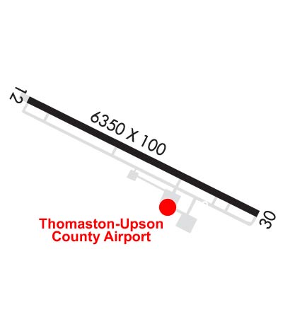
| Lat: N 3257.3 Long: W 08415.8 Elev: 798 Var: +03 Longest Runway: 6350 | ||
| AWOS: 133.97 CTAF: 122.8 | ||
| |||||||||||||||||||||||||||||||||||||||||||||||||||||||||||||
| |||||||||||||||||||||||||||||||||||||||||||||||||||||||||||||
| |||||||||||||||||||||||||||||||||||||||||||||||||||||||||||||
| Rwy | Rwy | |||||||
| 6350x100 | 5702' | 6350x100 | 5651' | 109.75 - 300° | ||||
| Runway ID | Single Wheel | Double Wheel | Double Tandem Wheel | Dual Double Wheel |
| 12/30 | 20,000 | 50,000 | N/A | N/A |
| These numbers are Advisory and are not limits. The Airport Manager should have more accurate Weight Limits | ||||
 Airport Diagram might not be current. | |
| Facility Name: | THOMASTON-UPSON COUNTY |
| City Name: | THOMASTON |
| County: | UPSON |
| State abbrev: | GA |
| State Name: | GEORGIA |
| Ownership: | PUBLICLY OWNED |
| Use: | OPEN TO THE PUBLIC |
| Owner's Name: | THOMASTON UPSON CO. ARPT AUTH |
| Address: | 2347 DERAY RD |
| THOMASTON, GA 30286 | |
| Owner's Phone: | 706-647-4500 |
| Manager's Name: | MITCH ELLERBEE |
| Address: | 2347 DEL RAY ROAD |
| THOMASTON, GA 30286 | |
| Phone: | 706-647-4500 |
| FAA Region: | SOUTHERN |
| FAA Field Office: | ATL |
| Date | Sunrise | Sunset |
|---|---|---|
| 06/07/26 Sunday | 6:28 | 20:44 |
| 06/08/26 Monday | 6:28 | 20:44 |
| 06/09/26 Tuesday | 6:28 | 20:45 |
| 06/10/26 Wednesday | 6:28 | 20:45 |
| 06/11/26 Thursday | 6:28 | 20:45 |
| 06/12/26 Friday | 6:28 | 20:46 |
| 06/13/26 Saturday | 6:28 | 20:46 |
| 06/14/26 Sunday | 6:28 | 20:47 |
| 06/15/26 Monday | 6:28 | 20:47 |
| 06/16/26 Tuesday | 6:28 | 20:47 |
| 06/17/26 Wednesday | 6:28 | 20:48 |
| 06/18/26 Thursday | 6:28 | 20:48 |
| 06/19/26 Friday | 6:29 | 20:48 |
| 06/20/26 Saturday | 6:29 | 20:48 |
| Airport Attendance Schedule | 7 Days A Week 0800-1800; FOR AFT HRS SVC CALL 706-741-0562. |
| Airport Status | OPERATIONAL (This Status can change at any time - please check NOTAMS) |
| Airport Lighting Schedule | ACTVT MALSR RY 30 AND PAPI RYS 12 & 30 - CTAF. MIRL RY 12/30 PRESET MED INTST DUSK-0000; AFTER 0000 ACTVT - CTAF. |
| Airport Storage Available | Tie Downs |
| Extra Services Available | Avionics, Flight Instruction, Parachute Jumping, Annual Surveying |
| Wind Indicator | YES - (lighted) |
| Control Tower | NO |
| CTAF Frequency | 122.800 |
| Unicom Frequency | 122.800 |
| Rotating Beacon Color | WG |
| Segmented Circle | YES |
| Landing Fee | NO |
| Airport Inspected | STATE - performed by STATE AERONAUTICAL PERSONNEL |
| Inspection Date | 04/22/2026 |
| Type of Fuel Available | Grade 100LL, JET A |
| Airframe Repair Service | MAJOR |
| Power Plant Repair Service | MAJOR |
| Latitude | N3257.3 |
| Longitude | W08415.8 (ESTIMATED) |
| Arpt Elevation | 797ft (SURVEYED) |
| Magnetic Variation | 03W |
| 5 miles NE | of THOMASTON |
| Traffic Pattern Altitude | |
| Sectional Chart | ATLANTA |
| Operations (Reported) | Yearly | Avg. Daily |
|---|---|---|
| General Aviation Transient | 0 | 0 |
| General Aviation Local | 0 | 0 |
| Air Taxi | 0 | 0 |
| Commerical | 0 | 0 |
| Commuter | 0 | 0 |
| Military | 0 | 0 |
| Aircraft based on Field | |
|---|---|
| General Aviation Singles | 0 |
| General Aviation Multi | 0 |
| Jet Aircraft | 0 |
| General Aviation Helicopters | 0 |
| Military Aircraft | 0 |
| Gliders | 0 |
| Ultralights | 0 |
| FSS on field | NO |
| FSS tie-in | MACON |
| FSS Phone | 1-800-WX-BRIEF |
| Who issues Notams | OPN |
| Notam D service at airport | YES |
| ARTCC Name | ATLANTA |
| Airport Certification | |
| Aircraft Rescue & Firefighting Index | None |
| Airport of Entry | No |
| Custom Landing Rights | No |
| Joint Civil/Military | No |
| Military Landing rights | No |
| NATIONAL PLAN OF INTEGRATED AIRPORT SYSTEMS (NPIAS) |
| GRANT AGREEMENTS UNDER FAAP/ADAP/AIP |
| ASSURANCES PURSUANT TO TITLE VI, CIVIL RIGHTS ACT OF 1964 |
| FOR CD CTC ATLANTA APCH AT 678-364-6132, WHEN APCH CLSD CTC ATLANTA ARTCC AT 770-210-7692. |
Airport Communications & Frequencies:
| |||||||||||||||||||||
| Runway: 12 | Runway: 30 | ||
| Mag heading: | 121° | Mag heading: | 301° |
| Rwy Slope: | .17% Up | Rwy Slope: | -.17% Down |
| Approach: | Approach: | ILS/DME | |
| Pattern: | Left Traffic | Pattern: | Left Traffic |
| Markings: | PRECISION INSTRUMENT | Markings: | PRECISION INSTRUMENT |
| Marking Condition: | GOOD | Marking Condition: | GOOD |
| Arresting Dev: | Arresting Dev: | ||
| Lat & Long: | N3257.5 W08416.4 | Lat. & Long.: | N3257.1 W08415.3 |
| Elev: | 786.8 ft. MSL | Elev: | 797.5 ft. MSL |
| TCH: | 32 ft. AGL | TCH: | 27 ft. AGL |
| Visual Glide Path: | 3.50 degrees | Visual Glide Path: | 3.00 degrees |
| Displaced Threshold: | 648 feet | Displaced Threshold: | 699 feet |
| Touchdown Zone: | YES | Touchdown Zone: | YES |
| Touchdown Elev.: | 790.7 feet | Touchdown Elev.: | 795.8 feet |
| Visual Glide Slope: | 2-Light PAPI on LEFT side of Runway | Visual Glide Slope: | 2-Light PAPI on LEFT side of Runway |
| RVR Equipment: | RVR Equipment: | ||
| RVV Equipment: | NO | RVV Equipment: | NO |
| Approach Lights: | Approach Lights: | MALSR - 1,400 foot medium intensity approach lighting system with runway alignment indicator lights | |
| REIL: | NO | REIL: | NO |
| Centerline Lights: | NO | Centerline Lights: | NO |
| Touchdown lights: | NO | Touchdown lights: | NO |
| Runway Category: | D | Runway Category: | Precision Instrument Runway |
| Declared Distances: | TORA:6350' TODA:6350' ASDA:6173' LDA:5525' | Declared Distances: | TORA:6350' TODA:6350' ASDA:5662' LDA:4962' |
| Obstructions: | ROAD | Obstructions: | RR |
| Marked: | NOT Marked/Lighted | Marked: | NOT Marked/Lighted |
| Clearance slope: | 34:1 APCH TO DSPLCD THLD. | Clearance slope: | 9:1; 50:1 APCH TO DSPLCD THLD. |
| Obstruction height: | 15 feet AGL | Obstruction height: | 19 feet AGL |
| Dist. from runway: | 201 feet | Dist. from runway: | 371 feet |
| Centerline offset: | 250 left of centerline | Centerline offset: | 524 feet right of centerline |
| Comments: | 6 FT FENCE AND ROAD 198 FT LEFT 200 FT FROM RY END. | Comments: |
Thanks for using FltPlan.com
all rights reserved © 1999-2026 by Flight Plan LLC