
| ST LANDRY PARISH-AHART FIELD OPELOUSAS LA |
| |
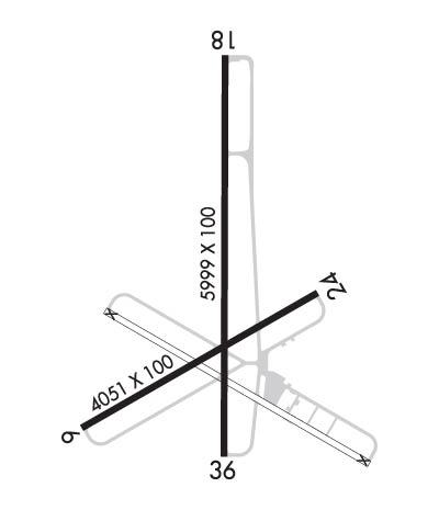
| Lat: N 3033.5 Long: W 09206.0 Elev: 75 Var: -01 Longest Runway: 5999 | ||
| AWOS: 118.77 CTAF: 123.0 | ||
| ||||||||||||||||||||||||||||||||||||||||||||
| ||||||||||||||||||||||||||||||||||||||||||||
| ||||||||||||||||||||||||||||||||||||||||||||
| Rwy | Rwy | |||||||
| 4051x100 | 3886' | 4051x100 | 3882' | |||||
| 5999x100 | 5849' | 5999x100 | 5210' | |||||
| Runway ID | Single Wheel | Double Wheel | Double Tandem Wheel | Dual Double Wheel |
| 06/24 | 30,000 | N/A | N/A | N/A |
| 18/36 | 30,000 | N/A | N/A | N/A |
| These numbers are Advisory and are not limits. The Airport Manager should have more accurate Weight Limits | ||||
 Airport Diagram might not be current. | |
| Facility Name: | ST LANDRY PARISH-AHART FLD |
| City Name: | OPELOUSAS |
| County: | ST LANDRY |
| State abbrev: | LA |
| State Name: | LOUISIANA |
| Ownership: | PUBLICLY OWNED |
| Use: | OPEN TO THE PUBLIC |
| Owner's Name: | ST. LANDRY PARISH GOVERNMENT |
| Address: | ST. LANDRY PARISH, P. O. DRAWER 1550 |
| OPELOUSAS, LA 70571 | |
| Owner's Phone: | 337-948-3688 |
| Manager's Name: | DANIELLE VIDRINE |
| Address: | 299 HANGAR RD. |
| OPELOUSAS, LA 70570 | |
| Phone: | 337-407-1551; AFTER HOURS EMERGENCY CELL 337-351-0025. |
| FAA Region: | SOUTHWEST |
| FAA Field Office: | LNM |
| Date | Sunrise | Sunset |
|---|---|---|
| 09/24/21 Friday | 6:58 | 19:03 |
| 09/25/21 Saturday | 6:58 | 19:01 |
| 09/26/21 Sunday | 6:59 | 19:00 |
| 09/27/21 Monday | 6:59 | 18:59 |
| 09/28/21 Tuesday | 7:00 | 18:58 |
| 09/29/21 Wednesday | 7:01 | 18:56 |
| 09/30/21 Thursday | 7:01 | 18:55 |
| 10/01/21 Friday | 7:02 | 18:54 |
| 10/02/21 Saturday | 7:02 | 18:53 |
| 10/03/21 Sunday | 7:03 | 18:51 |
| 10/04/21 Monday | 7:04 | 18:50 |
| 10/05/21 Tuesday | 7:04 | 18:49 |
| 10/06/21 Wednesday | 7:05 | 18:48 |
| 10/07/21 Thursday | 7:05 | 18:47 |
| Airport Attendance Schedule | MON-FRI 0800-1700, SAT 0800-1200 |
| Airport Status | OPERATIONAL (This Status can change at any time - please check NOTAMS) |
| Airport Lighting Schedule | MIRL RY 18/36, REIL RYS 18 & 36 PRESET LOW INTST DUSK-DAWN; TO INCR INTST ACTVT - CTAF. |
| Airport Storage Available | Tie Downs, Hanger |
| Extra Services Available | Crop Dusting |
| Wind Indicator | YES - (lighted) |
| Control Tower | NO |
| CTAF Frequency | 123.000 |
| Unicom Frequency | 123.000 |
| Rotating Beacon Color | CLEAR-GREEN (Light Land Airport) |
| Segmented Circle | YES |
| Landing Fee | NO |
| Airport Inspected | STATE - performed by STATE AERONAUTICAL PERSONNEL |
| Inspection Date | 06/15/2021 |
| Type of Fuel Available | Grade 100LL, JET A; -10CTC ARPT MGR FOR ACCEPTABLE FORMS OF PAYMENT FOR FUEL. |
| Airframe Repair Service | MINOR |
| Power Plant Repair Service | MINOR |
| Latitude | N3033.5 |
| Longitude | W09206.0 (ESTIMATED) |
| Arpt Elevation | 74ft (SURVEYED) |
| Magnetic Variation | 01E |
| 2 miles NW | of OPELOUSAS |
| Traffic Pattern Altitude | |
| Sectional Chart | HOUSTON |
| Operations (Reported) | Yearly | Avg. Daily |
|---|---|---|
| General Aviation Transient | 9000 | 25 |
| General Aviation Local | 15000 | 41 |
| Air Taxi | 0 | 0 |
| Commerical | 0 | 0 |
| Commuter | 0 | 0 |
| Military | 325 | 1 |
| Aircraft based on Field | |
|---|---|
| General Aviation Singles | 35 |
| General Aviation Multi | 2 |
| Jet Aircraft | 0 |
| General Aviation Helicopters | 3 |
| Military Aircraft | 0 |
| Gliders | 0 |
| Ultralights | 0 |
| FSS on field | NO |
| FSS tie-in | DE RIDDER |
| FSS Phone | 1-800-WX-BRIEF |
| Who issues Notams | OPL |
| Notam D service at airport | YES |
| ARTCC Name | HOUSTON |
| Airport Certification | |
| Aircraft Rescue & Firefighting Index | None |
| Airport of Entry | No |
| Custom Landing Rights | No |
| Joint Civil/Military | No |
| Military Landing rights | YES |
| NATIONAL PLAN OF INTEGRATED AIRPORT SYSTEMS (NPIAS) |
| GRANT AGREEMENTS UNDER FAAP/ADAP/AIP |
| ASSURANCES PURSUANT TO TITLE VI, CIVIL RIGHTS ACT OF 1964 |
| AGREEMENT UNDER DLAND OR DCLA HAS EXPIRED. |
| THIS AIRPORT HAS BEEN SURVEYED BY THE NATIONAL GEODETIC SURVEY. |
| FOR CD CTC LAFAYETTE APCH AT 337-262-2729, WHEN APCH CLSD CTC HOUSTON ARTCC AT 281-230-5622. |
| RWY 06/2 4 RY HAS SOME CRACKS WITH GRASS GROWING THRU CRACKS. |
Airport Communications & Frequencies:
| |||||||||||||||||
| Runway: 06 | Runway: 24 | ||
| Mag heading: | 59° | Mag heading: | 239° |
| Rwy Slope: | .12% Up | Rwy Slope: | -.12% Down |
| Approach: | Approach: | ||
| Pattern: | Left Traffic | Pattern: | Right Traffic |
| Markings: | BASIC | Markings: | BASIC |
| Marking Condition: | POOR; RY MARKINGS ARE FADED. | Marking Condition: | POOR; RY MARKINGS ARE FADED. |
| Arresting Dev: | Arresting Dev: | ||
| Lat & Long: | N3033.2 W09206.3 | Lat. & Long.: | N3033.5 W09205.7 |
| Elev: | 70.0 ft. MSL | Elev: | 74.7 ft. MSL |
| TCH: | TCH: | ||
| Visual Glide Path: | Visual Glide Path: | ||
| Displaced Threshold: | 165 feet | Displaced Threshold: | 169 feet |
| Touchdown Zone: | YES | Touchdown Zone: | YES |
| Touchdown Elev.: | 73.9 feet | Touchdown Elev.: | 74.7 feet |
| Visual Glide Slope: | Visual Glide Slope: | ||
| RVR Equipment: | RVR Equipment: | ||
| RVV Equipment: | NO | RVV Equipment: | NO |
| Approach Lights: | Approach Lights: | ||
| REIL: | NO | REIL: | NO |
| Centerline Lights: | NO | Centerline Lights: | NO |
| Touchdown lights: | NO | Touchdown lights: | NO |
| Runway Category: | Runway with a Visual Approach | Runway Category: | Runway with a Visual Approach |
| Declared Distances: | Declared Distances: | ||
| Obstructions: | TREES | Obstructions: | TREES |
| Marked: | NOT Marked/Lighted | Marked: | NOT Marked/Lighted |
| Clearance slope: | 10:1; APCH RATIO 10:1 FM DSPLCD THLD. | Clearance slope: | 3:1; APCH RATIO 19:1 FM DSPLCD THLD. |
| Obstruction height: | 45 feet AGL | Obstruction height: | 60 feet AGL |
| Dist. from runway: | 688 feet | Dist. from runway: | 397 feet |
| Centerline offset: | 107 left of centerline | Centerline offset: | 72 feet right of centerline |
| Comments: | Comments: |
| Runway: 18 | Runway: 36 | ||
| Mag heading: | 179° | Mag heading: | 359° |
| Rwy Slope: | .01% Up | Rwy Slope: | -.01% Down |
| Approach: | Approach: | ||
| Pattern: | Right Traffic | Pattern: | Left Traffic |
| Markings: | NONPRECISION INSTRUMENT | Markings: | NONPRECISION INSTRUMENT |
| Marking Condition: | GOOD | Marking Condition: | GOOD |
| Arresting Dev: | Arresting Dev: | ||
| Lat & Long: | N3034.1 W09205.9 | Lat. & Long.: | N3033.1 W09205.9 |
| Elev: | 71.1 ft. MSL | Elev: | 71.4 ft. MSL |
| TCH: | 58 ft. AGL | TCH: | 59 ft. AGL |
| Visual Glide Path: | 3.50 degrees | Visual Glide Path: | 3.50 degrees |
| Displaced Threshold: | 150 feet | Displaced Threshold: | 789 feet |
| Touchdown Zone: | YES | Touchdown Zone: | YES |
| Touchdown Elev.: | 71.4 feet | Touchdown Elev.: | 73.7 feet |
| Visual Glide Slope: | 2-Light PAPI on LEFT side of Runway | Visual Glide Slope: | 2-Light PAPI on LEFT side of Runway |
| RVR Equipment: | RVR Equipment: | ||
| RVV Equipment: | NO | RVV Equipment: | NO |
| Approach Lights: | Approach Lights: | ||
| REIL: | YES | REIL: | YES |
| Centerline Lights: | NO | Centerline Lights: | NO |
| Touchdown lights: | NO | Touchdown lights: | NO |
| Runway Category: | Runway with a Non-precision Approach having visibility minimums greater than 3/4 mile | Runway Category: | Runway with a Non-precision Approach having visibility minimums greater than 3/4 mile |
| Declared Distances: | Declared Distances: | ||
| Obstructions: | TREE | Obstructions: | ROAD |
| Marked: | NOT Marked/Lighted | Marked: | NOT Marked/Lighted |
| Clearance slope: | 15:1; APCH SLOPE 16:1 TO DSPLCD THLD. | Clearance slope: | 5:1; APCH SLOPE 30:1 TO DSPLCD THLD. |
| Obstruction height: | 48 feet AGL | Obstruction height: | 19 feet AGL |
| Dist. from runway: | 943 feet | Dist. from runway: | 307 feet |
| Centerline offset: | 114 left of centerline | Centerline offset: | |
| Comments: | Comments: |
Thanks for using FltPlan.com
all rights reserved © 1999-2021 by Flight Plan LLC
