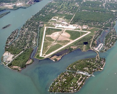
| GROSSE ILE MUNI DETROIT/GROSSE ILE MI |
| |
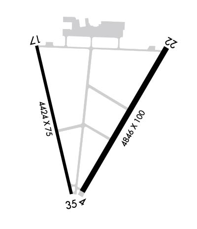
| Lat: N 4205.9 Long: W 08309.7 Elev: 591 Var: +07 Longest Runway: 4846 | ||
| AWOS: 119.67 CTAF: 123.0 | ||
| |||||||||||||||||||||||||||||||||||||||||||||||||||||||||||||
| |||||||||||||||||||||||||||||||||||||||||||||||||||||||||||||
| |||||||||||||||||||||||||||||||||||||||||||||||||||||||||||||
| |||||||||||||||||||||||||||||||||||||||||||||||||||||||||||||
| Rwy | Rwy | |||||||
| 4846x100 | 4846' | 4846x100 | 4418' | |||||
| 4424x75 | 3752' | 4424x75 | 4424' | |||||
| Runway ID | Single Wheel | Double Wheel | Double Tandem Wheel | Dual Double Wheel |
| 04/22 | 66,000 | 83,000 | 105,000 | N/A |
| 17/35 | 40,000 | 55,000 | 90,000 | N/A |
| These numbers are Advisory and are not limits. The Airport Manager should have more accurate Weight Limits | ||||
 Airport Diagram might not be current. | |
| Facility Name: | GROSSE ILE MUNI |
| City Name: | DETROIT/GROSSE ILE |
| County: | WAYNE |
| State abbrev: | MI |
| State Name: | MICHIGAN |
| Ownership: | PUBLICLY OWNED |
| Use: | OPEN TO THE PUBLIC |
| Owner's Name: | TOWNSHIP OF GROSSE ILE |
| Address: | 9601 GROH RD, PO BOX 129 |
| GROSSE ILE, MI 48138 | |
| Owner's Phone: | 734-675-0155 |
| Manager's Name: | MICHAEL DUKER |
| Address: | 9601 GROH RD, PO BOX 129 |
| GROSSE ILE, MI 48138 | |
| Phone: | 734-675-0155 |
| FAA Region: | GREAT LAKES |
| FAA Field Office: | DET |
| Date | Sunrise | Sunset |
|---|---|---|
| 09/24/21 Friday | 7:22 | 19:27 |
| 09/25/21 Saturday | 7:23 | 19:25 |
| 09/26/21 Sunday | 7:24 | 19:23 |
| 09/27/21 Monday | 7:25 | 19:22 |
| 09/28/21 Tuesday | 7:26 | 19:20 |
| 09/29/21 Wednesday | 7:27 | 19:18 |
| 09/30/21 Thursday | 7:28 | 19:16 |
| 10/01/21 Friday | 7:29 | 19:15 |
| 10/02/21 Saturday | 7:30 | 19:13 |
| 10/03/21 Sunday | 7:32 | 19:11 |
| 10/04/21 Monday | 7:33 | 19:09 |
| 10/05/21 Tuesday | 7:34 | 19:08 |
| 10/06/21 Wednesday | 7:35 | 19:06 |
| 10/07/21 Thursday | 7:36 | 19:04 |
| Airport Attendance Schedule | MON-FRI 0800-1800, SAT-SUN PRIOR ARNGMT |
| Airport Status | OPERATIONAL (This Status can change at any time - please check NOTAMS) |
| Airport Lighting Schedule | ACTVT REIL RWY 04 & 22; PAPI RWY 04, 22, 17, & 35; MIRL RWY 04/22 & 17/35 - CTAF. |
| Airport Storage Available | Tie Downs, Hanger |
| Extra Services Available | Charter, Flight Instruction, Aircraft Rental |
| Wind Indicator | YES - (lighted) |
| Control Tower | NO |
| CTAF Frequency | 123.000 |
| Unicom Frequency | 123.000 |
| Rotating Beacon Color | CLEAR-GREEN (Light Land Airport) |
| Segmented Circle | YES |
| Landing Fee | NO |
| Airport Inspected | STATE - performed by STATE AERONAUTICAL PERSONNEL |
| Inspection Date | 05/20/2021 |
| Type of Fuel Available | Grade 100LL, JET A (freeze point -40C) |
| Airframe Repair Service | MAJOR |
| Power Plant Repair Service | MAJOR |
| Latitude | N4205.9 |
| Longitude | W08309.7 (ESTIMATED) |
| Arpt Elevation | 590ft (SURVEYED) |
| Magnetic Variation | 07W |
| 2 miles S | of DETROIT/GROSSE ILE |
| Traffic Pattern Altitude | |
| Sectional Chart | DETROIT |
| Operations (Reported) | Yearly | Avg. Daily |
|---|---|---|
| General Aviation Transient | 6000 | 16 |
| General Aviation Local | 10000 | 27 |
| Air Taxi | 0 | 0 |
| Commerical | 0 | 0 |
| Commuter | 0 | 0 |
| Military | 0 | 0 |
| Aircraft based on Field | |
|---|---|
| General Aviation Singles | 53 |
| General Aviation Multi | 7 |
| Jet Aircraft | 0 |
| General Aviation Helicopters | 3 |
| Military Aircraft | 0 |
| Gliders | 0 |
| Ultralights | 0 |
| FSS on field | NO |
| FSS tie-in | LANSING |
| FSS Phone | 1-800-WX-BRIEF |
| Who issues Notams | ONZ |
| Notam D service at airport | YES |
| ARTCC Name | CLEVELAND |
| Airport Certification | ARPT CLSD TO ACR OPS GTR THAN 30 PAX SEATS EXC PPR CALL AMGR. |
| Aircraft Rescue & Firefighting Index | None |
| Airport of Entry | No |
| Custom Landing Rights | No |
| Joint Civil/Military | No |
| Military Landing rights | YES |
| NATIONAL PLAN OF INTEGRATED AIRPORT SYSTEMS (NPIAS) |
| GRANT AGREEMENTS UNDER FAAP/ADAP/AIP |
| SURPLUS PROPERTY AGREEMENT UNDER PUBLIC LAW 289 |
| ASSURANCES PURSUANT TO TITLE VI, CIVIL RIGHTS ACT OF 1964 |
| BIRDS & DEER ON & INVOF ARPT. |
| ULTRALIGHT & PWRD PRCHT ACT INVOF ARPT. |
| GCO AVBL ON FREQ 121.725 THRU DETROIT APCH CD & LANSING FSS. |
| FOR CD IF UNA VIA GCO CTC DETROIT APCH AT 800-499-8181. |
| RWY 17/3 5 EXTSV PEELING & CRACKING - FOD HAZ. |
Airport Communications & Frequencies:
| ||||||||||||||
| Runway: 04 | Runway: 22 | ||
| Mag heading: | 37° | Mag heading: | 217° |
| Rwy Slope: | .26% Up | Rwy Slope: | -.26% Down |
| Approach: | Approach: | ||
| Pattern: | Right Traffic | Pattern: | Left Traffic |
| Markings: | NONPRECISION INSTRUMENT | Markings: | NONPRECISION INSTRUMENT |
| Marking Condition: | GOOD | Marking Condition: | GOOD |
| Arresting Dev: | Arresting Dev: | ||
| Lat & Long: | N4205.6 W08309.7 | Lat. & Long.: | N4206.3 W08309.2 |
| Elev: | 576.8 ft. MSL | Elev: | 589.3 ft. MSL |
| TCH: | 40 ft. AGL | TCH: | 40 ft. AGL |
| Visual Glide Path: | 3.04 degrees | Visual Glide Path: | 3.04 degrees |
| Displaced Threshold: | No | Displaced Threshold: | 428 feet |
| Touchdown Zone: | YES | Touchdown Zone: | YES |
| Touchdown Elev.: | 587.9 feet | Touchdown Elev.: | 590.5 feet |
| Visual Glide Slope: | 4-Light PAPI on LEFT side of Runway | Visual Glide Slope: | 4-Light PAPI on LEFT side of Runway |
| RVR Equipment: | RVR Equipment: | ||
| RVV Equipment: | NO | RVV Equipment: | NO |
| Approach Lights: | Approach Lights: | ||
| REIL: | YES | REIL: | YES |
| Centerline Lights: | NO | Centerline Lights: | NO |
| Touchdown lights: | NO | Touchdown lights: | NO |
| Runway Category: | Runway with a Non-precision Approach having visibility minimums greater than 3/4 mile | Runway Category: | Runway with a Non-precision Approach having visibility minimums greater than 3/4 mile |
| Declared Distances: | Declared Distances: | ||
| Obstructions: | TREE | Obstructions: | TREES |
| Marked: | NOT Marked/Lighted | Marked: | NOT Marked/Lighted |
| Clearance slope: | 17:1 | Clearance slope: | 13:1; APCH RATIO 25:1 TO DTHR. |
| Obstruction height: | 34 feet AGL | Obstruction height: | 75 feet AGL |
| Dist. from runway: | 795 feet | Dist. from runway: | 1190 feet |
| Centerline offset: | 308 left of centerline | Centerline offset: | 382 feet left of centerline |
| Comments: | Comments: |
| Runway: 17 | Runway: 35 | ||
| Mag heading: | 174° | Mag heading: | 354° |
| Rwy Slope: | -.07% Down | Rwy Slope: | .07% Up |
| Approach: | Approach: | ||
| Pattern: | Left Traffic | Pattern: | Right Traffic |
| Markings: | BASIC | Markings: | BASIC |
| Marking Condition: | FAIR | Marking Condition: | FAIR |
| Arresting Dev: | Arresting Dev: | ||
| Lat & Long: | N4206.3 W08310.0 | Lat. & Long.: | N4205.6 W08309.8 |
| Elev: | 581.3 ft. MSL | Elev: | 578.3 ft. MSL |
| TCH: | 26 ft. AGL | TCH: | 20 ft. AGL |
| Visual Glide Path: | 3.00 degrees | Visual Glide Path: | 3.00 degrees |
| Displaced Threshold: | 672 feet | Displaced Threshold: | No |
| Touchdown Zone: | YES | Touchdown Zone: | YES |
| Touchdown Elev.: | 580.3 feet | Touchdown Elev.: | 579.7 feet |
| Visual Glide Slope: | 4-Light PAPI on LEFT side of Runway | Visual Glide Slope: | 4-Light PAPI on LEFT side of Runway |
| RVR Equipment: | RVR Equipment: | ||
| RVV Equipment: | NO | RVV Equipment: | NO |
| Approach Lights: | Approach Lights: | ||
| REIL: | NO | REIL: | NO |
| Centerline Lights: | NO | Centerline Lights: | NO |
| Touchdown lights: | NO | Touchdown lights: | NO |
| Runway Category: | Runway with a Visual Approach | Runway Category: | Runway with a Visual Approach |
| Declared Distances: | Declared Distances: | ||
| Obstructions: | TREES | Obstructions: | |
| Marked: | NOT Marked/Lighted | Marked: | |
| Clearance slope: | 12:1; APCH RATIO 22:1 TO DTHR. | Clearance slope: | 20:1 |
| Obstruction height: | 80 feet AGL | Obstruction height: | |
| Dist. from runway: | 1180 feet | Dist. from runway: | |
| Centerline offset: | 40 right of centerline | Centerline offset: | |
| Comments: | Comments: |
Thanks for using FltPlan.com
all rights reserved © 1999-2021 by Flight Plan LLC