
| CURRITUCK COUNTY RGNL CURRITUCK NC |
| |
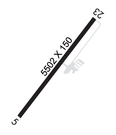
| Lat: N 3624.0 Long: W 07600.9 Elev: 18 Var: +10 Longest Runway: 5502 | ||
| AWOS: 119.77 CTAF: 122.9 | ||
| ||||||||||||||||||||||||||||||||
| ||||||||||||||||||||||||||||||||
| ||||||||||||||||||||||||||||||||
| Rwy | Rwy | |||||||
| 5502x150 | 5502' | 5502x150 | 5502' | |||||
| Runway ID | Single Wheel | Double Wheel | Double Tandem Wheel | Dual Double Wheel |
| 05/23 | 35,000 | 47,500 | N/A | N/A |
| These numbers are Advisory and are not limits. The Airport Manager should have more accurate Weight Limits | ||||
 Airport Diagram might not be current. | |
| Facility Name: | CURRITUCK COUNTY RGNL |
| City Name: | CURRITUCK |
| County: | CURRITUCK |
| State abbrev: | NC |
| State Name: | NORTH CAROLINA |
| Ownership: | PUBLICLY OWNED |
| Use: | OPEN TO THE PUBLIC |
| Owner's Name: | COUNTY OF CURRITUCK |
| Address: | 153 COURTHOUSE ROAD, SUITE 800 |
| CURRITUCK, NC 27929-9653 | |
| Owner's Phone: | 252-453-8032 |
| Manager's Name: | WILLIAM NELSON |
| Address: | 264 AIRPORT RD (PHYSICAL ADDRESS), 153 COURTHOUSE ROAD, SUITE 302 |
| CURRITUCK, NC 27929 | |
| Phone: | (252) 453-2876; OR 252-453-8032. |
| FAA Region: | SOUTHERN |
| FAA Field Office: | MEM |
| Date | Sunrise | Sunset |
|---|---|---|
| 06/08/26 Monday | 5:46 | 20:20 |
| 06/09/26 Tuesday | 5:46 | 20:21 |
| 06/10/26 Wednesday | 5:46 | 20:21 |
| 06/11/26 Thursday | 5:46 | 20:22 |
| 06/12/26 Friday | 5:46 | 20:22 |
| 06/13/26 Saturday | 5:46 | 20:23 |
| 06/14/26 Sunday | 5:46 | 20:23 |
| 06/15/26 Monday | 5:46 | 20:23 |
| 06/16/26 Tuesday | 5:46 | 20:24 |
| 06/17/26 Wednesday | 5:46 | 20:24 |
| 06/18/26 Thursday | 5:46 | 20:24 |
| 06/19/26 Friday | 5:46 | 20:25 |
| 06/20/26 Saturday | 5:46 | 20:25 |
| 06/21/26 Sunday | 5:46 | 20:25 |
| Airport Attendance Schedule | 7 Days A Week 0800-1600; UNATNDD ON ALL STATE HOLIDAYS. |
| Airport Status | OPERATIONAL (This Status can change at any time - please check NOTAMS) |
| Airport Lighting Schedule | ACTVT REIL RWY 05 & 23; MIRL RWY 05/23 AFT SS - CTAF. PAPI RWY 05 & 23 ON CONSLY; TO INCR INTST - CTAF. |
| Airport Storage Available | Tie Downs |
| Extra Services Available | Flight Instruction |
| Wind Indicator | YES - (lighted) |
| Control Tower | NO |
| CTAF Frequency | 122.900 |
| Unicom Frequency | |
| Rotating Beacon Color | WG |
| Segmented Circle | YES |
| Landing Fee | NO |
| Airport Inspected | STATE - performed by STATE AERONAUTICAL PERSONNEL |
| Inspection Date | 07/22/2024 |
| Type of Fuel Available | Grade 100LL, JET A-1 (icing inhibitor, freeze point -50C); -10FUEL AVBL 24 HRS WITH CREDIT CARD. |
| Airframe Repair Service | MAJOR |
| Power Plant Repair Service | MAJOR |
| Latitude | N3624.0 |
| Longitude | W07600.9 (ESTIMATED) |
| Arpt Elevation | 17ft (SURVEYED) |
| Magnetic Variation | 10W |
| 4 miles S | of CURRITUCK |
| Traffic Pattern Altitude | |
| Sectional Chart | WASHINGTON |
| Operations (Reported) | Yearly | Avg. Daily |
|---|---|---|
| General Aviation Transient | 0 | 0 |
| General Aviation Local | 0 | 0 |
| Air Taxi | 0 | 0 |
| Commerical | 0 | 0 |
| Commuter | 0 | 0 |
| Military | 0 | 0 |
| Aircraft based on Field | |
|---|---|
| General Aviation Singles | 0 |
| General Aviation Multi | 0 |
| Jet Aircraft | 0 |
| General Aviation Helicopters | 0 |
| Military Aircraft | 0 |
| Gliders | 0 |
| Ultralights | 0 |
| FSS on field | NO |
| FSS tie-in | RALEIGH |
| FSS Phone | 1-800-WX-BRIEF |
| Who issues Notams | ONX |
| Notam D service at airport | YES |
| ARTCC Name | WASHINGTON |
| Airport Certification | |
| Aircraft Rescue & Firefighting Index | None |
| Airport of Entry | No |
| Custom Landing Rights | No |
| Joint Civil/Military | No |
| Military Landing rights | YES |
| NATIONAL PLAN OF INTEGRATED AIRPORT SYSTEMS (NPIAS) |
| BIRDS & DEER ON AND INVOF ARPT. |
| FOR CD CTC OCEANA APCH AT 757-433-2968. |
Airport Communications & Frequencies:
| ||||||||||||
| Runway: 05 | Runway: 23 | ||
| Mag heading: | 45° | Mag heading: | 225° |
| Rwy Slope: | .03% Up | Rwy Slope: | -.03% Down |
| Approach: | Approach: | ||
| Pattern: | Left Traffic | Pattern: | Left Traffic |
| Markings: | NONPRECISION INSTRUMENT | Markings: | NONPRECISION INSTRUMENT |
| Marking Condition: | GOOD | Marking Condition: | GOOD |
| Arresting Dev: | Arresting Dev: | ||
| Lat & Long: | N3623.6 W07601.2 | Lat. & Long.: | N3624.4 W07600.6 |
| Elev: | 12.7 ft. MSL | Elev: | 14.1 ft. MSL |
| TCH: | 43 ft. AGL | TCH: | 41 ft. AGL |
| Visual Glide Path: | 3.00 degrees | Visual Glide Path: | 3.00 degrees |
| Displaced Threshold: | No | Displaced Threshold: | No |
| Touchdown Zone: | YES | Touchdown Zone: | YES |
| Touchdown Elev.: | 17.7 feet | Touchdown Elev.: | 17.7 feet |
| Visual Glide Slope: | 4-Light PAPI on RIGHT side of Runway | Visual Glide Slope: | 2-Light PAPI on LEFT side of Runway |
| RVR Equipment: | RVR Equipment: | ||
| RVV Equipment: | NO | RVV Equipment: | NO |
| Approach Lights: | Approach Lights: | ||
| REIL: | YES | REIL: | YES |
| Centerline Lights: | NO | Centerline Lights: | NO |
| Touchdown lights: | NO | Touchdown lights: | NO |
| Runway Category: | Runway with a Non-precision Approach having visibility minimums greater than 3/4 mile | Runway Category: | Runway with a Non-precision Approach having visibility minimums greater than 3/4 mile |
| Declared Distances: | Declared Distances: | ||
| Obstructions: | PLINE | Obstructions: | TREES |
| Marked: | NOT Marked/Lighted | Marked: | NOT Marked/Lighted |
| Clearance slope: | 30:1 | Clearance slope: | 24:1 |
| Obstruction height: | 106 feet AGL | Obstruction height: | 24 feet AGL |
| Dist. from runway: | 3395 feet | Dist. from runway: | 793 feet |
| Centerline offset: | 148 right of centerline | Centerline offset: | 232 feet left of centerline |
| Comments: | Comments: |
Thanks for using FltPlan.com
all rights reserved © 1999-2026 by Flight Plan LLC