
| ONTARIO INTL ONTARIO CA |
| |
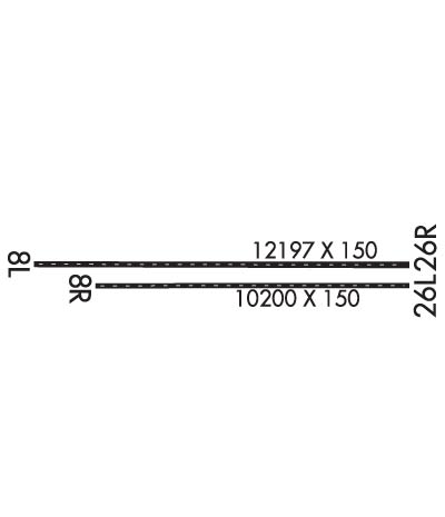
| Lat: N 3403.4 Long: W 11736.1 Elev: 944 Var: -12 Longest Runway: 12197 | ||
| Clr Del: 118.1 Dept. ATIS: 124.25 Arr. ATIS: 124.25 Ground: 121.9 Tower: 120.6 | ||
| ||||||||||||||||||||||||||||||||||||||||||||
| ||||||||||||||||||||||||||||||||||||||||||||
| ||||||||||||||||||||||||||||||||||||||||||||
| ||||||||||||||||||||||||||||||||||||||||||||
| Rwy | Rwy | |||||||
| 12197x150 | 11200' | 109.70 - 077° | 12197x150 | 12197' | 109.70 - 257° | |||
| 10200x150 | 10200' | 10200x150 | 10200' | 111.35 - 257° | ||||
| Runway ID | Single Wheel | Double Wheel | Double Tandem Wheel | Dual Double Wheel |
| 08L/26R | 30,000 | 200,000 | 560,000 | 850,000 |
| 08R/26L | 30,000 | 200,000 | 560,000 | 850,000 |
| These numbers are Advisory and are not limits. The Airport Manager should have more accurate Weight Limits | ||||
 Airport Diagram might not be current. | |
| Facility Name: | ONTARIO INTL |
| City Name: | ONTARIO |
| County: | SAN BERNARDINO |
| State abbrev: | CA |
| State Name: | CALIFORNIA |
| Ownership: | PUBLICLY OWNED |
| Use: | OPEN TO THE PUBLIC |
| Owner's Name: | ONTARIO INTL AIRPORT AUTHORITY |
| Address: | 1923 EAST AVION STREET |
| ONTARIO, CA 91761 | |
| Owner's Phone: | (909) 544-5300 |
| Manager's Name: | MARK THORPE |
| Address: | 1923 EAST AVION STREET |
| ONTARIO, CA 91761 | |
| Phone: | 909-544-5300 |
| FAA Region: | WESTERN-PACIFIC |
| FAA Field Office: | LAX |
| Date | Sunrise | Sunset |
|---|---|---|
| 09/24/21 Friday | 6:40 | 18:45 |
| 09/25/21 Saturday | 6:40 | 18:43 |
| 09/26/21 Sunday | 6:41 | 18:42 |
| 09/27/21 Monday | 6:42 | 18:40 |
| 09/28/21 Tuesday | 6:43 | 18:39 |
| 09/29/21 Wednesday | 6:43 | 18:38 |
| 09/30/21 Thursday | 6:44 | 18:36 |
| 10/01/21 Friday | 6:45 | 18:35 |
| 10/02/21 Saturday | 6:45 | 18:33 |
| 10/03/21 Sunday | 6:46 | 18:32 |
| 10/04/21 Monday | 6:47 | 18:31 |
| 10/05/21 Tuesday | 6:48 | 18:29 |
| 10/06/21 Wednesday | 6:48 | 18:28 |
| 10/07/21 Thursday | 6:49 | 18:27 |
| Airport Attendance Schedule | CONTINUOUS |
| Airport Status | OPERATIONAL (This Status can change at any time - please check NOTAMS) |
| Airport Lighting Schedule | |
| Airport Storage Available | NONE |
| Extra Services Available | Air Freight, Avionics, Cargo Handling, Charter, Aircraft Sales |
| Wind Indicator | YES - (lighted) |
| Control Tower | YES |
| CTAF Frequency | |
| Unicom Frequency | |
| Rotating Beacon Color | CLEAR-GREEN (Light Land Airport) |
| Segmented Circle | NO |
| Landing Fee | NO |
| Airport Inspected | FEDERAL - performed by FAA AIRPORTS FIELD PERSONNEL |
| Inspection Date | 09/05/2019 |
| Type of Fuel Available | Grade 100LL, JET A (freeze point -40C) |
| Airframe Repair Service | MAJOR |
| Power Plant Repair Service | MAJOR |
| Latitude | N3403.4 |
| Longitude | W11736.1 (ESTIMATED) |
| Arpt Elevation | 944ft (SURVEYED) |
| Magnetic Variation | 12E |
| 2 miles E | of ONTARIO |
| Traffic Pattern Altitude | |
| Sectional Chart | LOS ANGELES |
| Operations (Reported) | Yearly | Avg. Daily |
|---|---|---|
| General Aviation Transient | 10989 | 30 |
| General Aviation Local | 5511 | 15 |
| Air Taxi | 13396 | 37 |
| Commerical | 70247 | 192 |
| Commuter | 0 | 0 |
| Military | 336 | 1 |
| Aircraft based on Field | |
|---|---|
| General Aviation Singles | 0 |
| General Aviation Multi | 1 |
| Jet Aircraft | 14 |
| General Aviation Helicopters | 0 |
| Military Aircraft | 0 |
| Gliders | 0 |
| Ultralights | 0 |
| FSS on field | NO |
| FSS tie-in | RIVERSIDE |
| FSS Phone | 1-800-WX-BRIEF |
| Who issues Notams | ONT |
| Notam D service at airport | YES |
| ARTCC Name | LOS ANGELES |
| Airport Certification | AIRPORT RECEIVING SCHEDULED AIR CARRIER SERVICE FROM CARRIERS CERTIFICATED BY THE CIVIL AERONAUTICS BOARD |
| Aircraft Rescue & Firefighting Index | AIRPORT HAS A CERTIFICATE UNDER CFR PART 139 |
| Airport of Entry | No |
| Custom Landing Rights | No |
| Joint Civil/Military | No |
| Military Landing rights | YES |
| NATIONAL PLAN OF INTEGRATED AIRPORT SYSTEMS (NPIAS) |
| GRANT AGREEMENTS UNDER FAAP/ADAP/AIP |
| SURPLUS PROPERTY AGREEMENT UNDER PUBLIC LAW 289 |
| ASSURANCES PURSUANT TO TITLE VI, CIVIL RIGHTS ACT OF 1964 |
| FBO ON FREQ 130.75. |
| WILDLIFE HAZARD MGT PLAN IN EFFECT; POTENTIAL BIRD HAZARDS MAY EXIST ON AND INVOF ARPT; BE ALERT TO LARGE NUMBERS OF STARLINGS AND CROWS POSSIBLE ON APCH TO RY 26L AND RY 26R, HAWKS, EAGLES, FALCONS AND OWLS SPOTTED ON OCCASION. |
| TWY S-4 RSTD TO ACFT WITH WINGSPAN 117 FT OR SMALLER. |
| PILOTS SHOULD USE JUDGEMENTAL OVERSTEER ON TWY S-4. |
| NOISE ABATEMENT PROCEDURES IN EFFECT; FULL-LENGTH TURBOJET DEP ENCOURAGED, NIGHTLY PREFERENTIAL RWY USAGE, 2200-0700. |
| EASTBOUND B747, B777, A330, A340 OR LARGER ACFT ON TWY S PROHIBITED FROM NORTHBOUND TURNS ONTO TWY K. |
| B747, B777, A330, A340 OR LARGER ACFT ON TWY S PROHIBITED FROM NORTHBOUND TURNS ONTO TWY P. |
| ACFT PRKG AND CONTR GND SVCS ARE LTD FOR UNSKED OPS. FOR SKED INFO CALL AIRFIELD OPS (909) 214-7682/7683. |
| TWY Y EAST OF TWY W IS A NON-MOVEMENT AREA; ALL ACFT CTC RAMP CTL 131.325 FOR ACCESS. |
| ALL MILITARY AND GENERAL AVIATION (FIXED OR ROTOR WING) ACFT OPS ARE RESTRICTED TO FBO FACILITIES WITH ADVANCE COORDINATION; OVERNIGHT TIEDOWN AND PARKING FEE. |
| PTNS OF TWY S IN THE VCY OF TWY F ARE NOT VSB FM ATCT; PILOTS USE CTN ENTERING TWY F SOUTH OF TWY S. |
| ACFT ACCESS TO TWY R FROM RWY 26R PROHIBITED |
| TWY F SOUTH OF TWY S RSTRD TO ACFT WITH 117 FT WINGSPAN AND SMALLER. TWY F SOUTH OF RWY 26L RSTRD TO ACFT WITH 180 FT WINGSPAN. |
Airport Communications & Frequencies:
| |||||||||||||||||||||||||||||||||||||||||||||||||||||||||||||||||
| Runway: 08L | Runway: 26R | ||
| Mag heading: | 78° | Mag heading: | 258° |
| Rwy Slope: | -.09% Down | Rwy Slope: | .09% Up |
| Approach: | ILS | Approach: | ILS/DME |
| Pattern: | Left Traffic | Pattern: | Right Traffic |
| Markings: | PRECISION INSTRUMENT | Markings: | PRECISION INSTRUMENT |
| Marking Condition: | GOOD | Marking Condition: | GOOD |
| Arresting Dev: | Arresting Dev: | ||
| Lat & Long: | N3403.4 W11737.4 | Lat. & Long.: | N3403.4 W11735.0 |
| Elev: | 943.2 ft. MSL | Elev: | 931.8 ft. MSL |
| TCH: | 62 ft. AGL | TCH: | 75 ft. AGL |
| Visual Glide Path: | 3.00 degrees | Visual Glide Path: | 3.00 degrees |
| Displaced Threshold: | 997 feet | Displaced Threshold: | No |
| Touchdown Zone: | YES | Touchdown Zone: | YES |
| Touchdown Elev.: | 944.1 feet | Touchdown Elev.: | 931.8 feet |
| Visual Glide Slope: | 4-Light PAPI on LEFT side of Runway | Visual Glide Slope: | 4-Light PAPI on LEFT side of Runway |
| RVR Equipment: | TOUCHDOWN-MIDFIELD-ROLLOUT | RVR Equipment: | TOUCHDOWN-MIDFIELD-ROLLOUT |
| RVV Equipment: | YES | RVV Equipment: | YES |
| Approach Lights: | MALSR - 1,400 foot medium intensity approach lighting system with runway alignment indicator lights | Approach Lights: | MALSR - 1,400 foot medium intensity approach lighting system with runway alignment indicator lights |
| REIL: | NO | REIL: | NO |
| Centerline Lights: | YES | Centerline Lights: | YES |
| Touchdown lights: | YES | Touchdown lights: | NO |
| Runway Category: | Precision Instrument Runway | Runway Category: | Precision Instrument Runway |
| Declared Distances: | TORA:12197' TODA:12197' ASDA:12197' LDA:11200' | Declared Distances: | TORA:12197' TODA:12197' ASDA:12197' LDA:12197' |
| Obstructions: | RR | Obstructions: | POLE |
| Marked: | NOT Marked/Lighted | Marked: | NOT Marked/Lighted |
| Clearance slope: | 20:1; APCH RATIO 50:1 TO DSPLCD THR. | Clearance slope: | 46:1 |
| Obstruction height: | 20 feet AGL | Obstruction height: | 40 feet AGL |
| Dist. from runway: | 600 feet | Dist. from runway: | 2050 feet |
| Centerline offset: | 250 right of centerline | Centerline offset: | 400 feet right of centerline |
| Comments: | Comments: |
| Runway: 08R | Runway: 26L | ||
| Mag heading: | 78° | Mag heading: | 258° |
| Rwy Slope: | -.10% Down | Rwy Slope: | .10% Up |
| Approach: | Approach: | ILS/DME | |
| Pattern: | Right Traffic | Pattern: | Left Traffic |
| Markings: | PRECISION INSTRUMENT | Markings: | PRECISION INSTRUMENT |
| Marking Condition: | GOOD | Marking Condition: | GOOD |
| Arresting Dev: | Arresting Dev: | ||
| Lat & Long: | N3403.3 W11737.0 | Lat. & Long.: | N3403.3 W11735.0 |
| Elev: | 936.0 ft. MSL | Elev: | 926.2 ft. MSL |
| TCH: | 65 ft. AGL | TCH: | 74 ft. AGL |
| Visual Glide Path: | 3.00 degrees | Visual Glide Path: | 3.00 degrees |
| Displaced Threshold: | No | Displaced Threshold: | No |
| Touchdown Zone: | YES | Touchdown Zone: | YES |
| Touchdown Elev.: | 936.0 feet | Touchdown Elev.: | 926.2 feet |
| Visual Glide Slope: | 4-Light PAPI on LEFT side of Runway | Visual Glide Slope: | 4-Light PAPI on RIGHT side of Runway |
| RVR Equipment: | TOUCHDOWN-MIDFIELD-ROLLOUT | RVR Equipment: | TOUCHDOWN-MIDFIELD-ROLLOUT |
| RVV Equipment: | YES | RVV Equipment: | YES |
| Approach Lights: | Approach Lights: | ALSF2 - standard 2,400 foot high intensity approach lighting system with sequenced flashers, Category II or III | |
| REIL: | NO | REIL: | NO |
| Centerline Lights: | YES | Centerline Lights: | YES |
| Touchdown lights: | NO | Touchdown lights: | YES |
| Runway Category: | Runway with a Non-precision Approach having visibility minimums greater than 3/4 mile | Runway Category: | Precision Instrument Runway |
| Declared Distances: | TORA:10200' TODA:10200' ASDA:10200' LDA:10200' | Declared Distances: | TORA:10200' TODA:10200' ASDA:10200' LDA:10200' |
| Obstructions: | Obstructions: | POLE | |
| Marked: | Marked: | NOT Marked/Lighted | |
| Clearance slope: | 50:1 | Clearance slope: | 46:1 |
| Obstruction height: | Obstruction height: | 40 feet AGL | |
| Dist. from runway: | Dist. from runway: | 2050 feet | |
| Centerline offset: | Centerline offset: | 400 feet left of centerline | |
| Comments: | Comments: |
Thanks for using FltPlan.com
all rights reserved © 1999-2021 by Flight Plan LLC