| NEWPORT MUNI NEWPORT OR |
| |
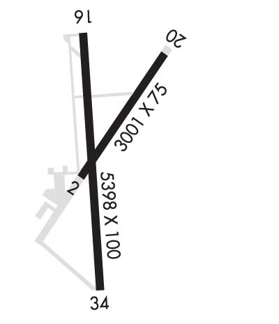
| Lat: N 4434.8 Long: W 12403.5 Elev: 160 Var: -15 Longest Runway: 5398 | ||
| AWOS: 133.9 CTAF: 122.8 | ||
| ||||||||||||||||||||||||||||||||||||||||||||||||||||||||||||||||||||
| ||||||||||||||||||||||||||||||||||||||||||||||||||||||||||||||||||||
| ||||||||||||||||||||||||||||||||||||||||||||||||||||||||||||||||||||
| Rwy | Rwy | |||||||
| 3001x75 | 3001' | 3001x75 | 3001' | |||||
| 5398x100 | 5398' | 111.50 - 162° | 5398x100 | 5098' | ||||
| Runway ID | Single Wheel | Double Wheel | Double Tandem Wheel | Dual Double Wheel |
| 02/20 | 33,000 | 50,000 | 84,000 | N/A |
| 16/34 | 75,000 | 120,000 | 170,000 | N/A |
| These numbers are Advisory and are not limits. The Airport Manager should have more accurate Weight Limits | ||||
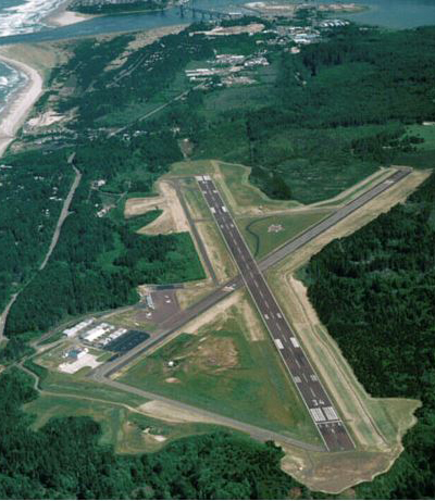
 Airport Diagram might not be current. | |
| Facility Name: | NEWPORT MUNI |
| City Name: | NEWPORT |
| County: | LINCOLN |
| State abbrev: | OR |
| State Name: | OREGON |
| Ownership: | PUBLICLY OWNED |
| Use: | OPEN TO THE PUBLIC |
| Owner's Name: | CITY OF NEWPORT |
| Address: | 169 SW COAST HWY |
| NEWPORT, OR 97365 | |
| Owner's Phone: | 541-574-0603 |
| Manager's Name: | LANCE VANDERBECK |
| Address: | 135 SE 84TH |
| NEWPORT, OR 97365 | |
| Phone: | (541) 867-7422 |
| FAA Region: | NORTHWEST MOUNTAIN |
| FAA Field Office: | SEA |
| Date | Sunrise | Sunset |
|---|---|---|
| 09/24/21 Friday | 7:06 | 19:10 |
| 09/25/21 Saturday | 7:07 | 19:08 |
| 09/26/21 Sunday | 7:08 | 19:06 |
| 09/27/21 Monday | 7:09 | 19:05 |
| 09/28/21 Tuesday | 7:10 | 19:03 |
| 09/29/21 Wednesday | 7:11 | 19:01 |
| 09/30/21 Thursday | 7:13 | 18:59 |
| 10/01/21 Friday | 7:14 | 18:57 |
| 10/02/21 Saturday | 7:15 | 18:55 |
| 10/03/21 Sunday | 7:16 | 18:53 |
| 10/04/21 Monday | 7:18 | 18:52 |
| 10/05/21 Tuesday | 7:19 | 18:50 |
| 10/06/21 Wednesday | 7:20 | 18:48 |
| 10/07/21 Thursday | 7:21 | 18:46 |
| Airport Attendance Schedule | 7 Days A Week 0800-1700 |
| Airport Status | OPERATIONAL (This Status can change at any time - please check NOTAMS) |
| Airport Lighting Schedule | ACTVT MALSR RWY 16; MIRL RYS 02/20 & HIRL 16/34 AND PAPIS RWY 16 & RWY 34 AND REIL RY 34 - CTAF. |
| Airport Storage Available | Tie Downs, Hanger |
| Extra Services Available | Air Freight |
| Wind Indicator | YES - (lighted) |
| Control Tower | NO |
| CTAF Frequency | 122.800 |
| Unicom Frequency | 122.800 |
| Rotating Beacon Color | CLEAR-GREEN (Light Land Airport) |
| Segmented Circle | YES |
| Landing Fee | NO |
| Airport Inspected | FEDERAL - performed by STATE AERONAUTICAL PERSONNEL |
| Inspection Date | 08/17/2020 |
| Type of Fuel Available | Grade 100LL, JET A (freeze point -40C); -10FOR FUEL AFT HRS CALL 541-867-7422 OR 541-530-1364. |
| Airframe Repair Service | None |
| Power Plant Repair Service | None |
| Latitude | N4434.8 |
| Longitude | W12403.5 (ESTIMATED) |
| Arpt Elevation | 160ft (SURVEYED) |
| Magnetic Variation | 15E |
| 3 miles S | of NEWPORT |
| Traffic Pattern Altitude | |
| Sectional Chart | SEATTLE |
| Operations (Reported) | Yearly | Avg. Daily |
|---|---|---|
| General Aviation Transient | 10500 | 29 |
| General Aviation Local | 4000 | 11 |
| Air Taxi | 1450 | 4 |
| Commerical | 0 | 0 |
| Commuter | 0 | 0 |
| Military | 4000 | 11 |
| Aircraft based on Field | |
|---|---|
| General Aviation Singles | 24 |
| General Aviation Multi | 1 |
| Jet Aircraft | 1 |
| General Aviation Helicopters | 2 |
| Military Aircraft | 2 |
| Gliders | 0 |
| Ultralights | 0 |
| FSS on field | NO |
| FSS tie-in | MC MINNVILLE |
| FSS Phone | 1-800-WX-BRIEF |
| Who issues Notams | ONP |
| Notam D service at airport | YES |
| ARTCC Name | SEATTLE |
| Airport Certification | PPR FOR ACR OPNS WITH MORE THAN 30 PSGR SEATS CALL AMGR 541-867-7422. |
| Aircraft Rescue & Firefighting Index | None |
| Airport of Entry | No |
| Custom Landing Rights | No |
| Joint Civil/Military | No |
| Military Landing rights | YES |
| NATIONAL PLAN OF INTEGRATED AIRPORT SYSTEMS (NPIAS) |
| GRANT AGREEMENTS UNDER FAAP/ADAP/AIP |
| SURPLUS PROPERTY AGREEMENT UNDER REGULATION 16-WAA |
| ASSURANCES PURSUANT TO TITLE VI, CIVIL RIGHTS ACT OF 1964 |
| AGREEMENT UNDER DLAND OR DCLA HAS EXPIRED. |
| BIRDS, DEER & COYOTES ON AND INVOF ARPT. |
| FOR CD IF UNA TO CTC ON FSS FREQ, CTC SEATTLE ARTCC AT 253-351-3694. |
Airport Communications & Frequencies:
| |||||||||
| Runway: 02 | Runway: 20 | ||
| Mag heading: | 22° | Mag heading: | 202° |
| Rwy Slope: | 1.00% Up | Rwy Slope: | -1.00% Down |
| Approach: | Approach: | ||
| Pattern: | Left Traffic | Pattern: | Right Traffic |
| Markings: | BASIC | Markings: | BASIC |
| Marking Condition: | GOOD | Marking Condition: | GOOD |
| Arresting Dev: | Arresting Dev: | ||
| Lat & Long: | N4434.7 W12403.6 | Lat. & Long.: | N4435.1 W12403.2 |
| Elev: | 130.0 ft. MSL | Elev: | 160.1 ft. MSL |
| TCH: | TCH: | ||
| Visual Glide Path: | Visual Glide Path: | ||
| Displaced Threshold: | No | Displaced Threshold: | No |
| Touchdown Zone: | YES | Touchdown Zone: | YES |
| Touchdown Elev.: | 160.1 feet | Touchdown Elev.: | 160.1 feet |
| Visual Glide Slope: | Visual Glide Slope: | ||
| RVR Equipment: | RVR Equipment: | ||
| RVV Equipment: | NO | RVV Equipment: | NO |
| Approach Lights: | Approach Lights: | ||
| REIL: | NO | REIL: | NO |
| Centerline Lights: | NO | Centerline Lights: | NO |
| Touchdown lights: | NO | Touchdown lights: | NO |
| Runway Category: | Runway with a Visual Approach | Runway Category: | Runway with a Visual Approach |
| Declared Distances: | TORA:3001' TODA:3001' ASDA:3001' LDA:3001' | Declared Distances: | TORA:3001' TODA:3001' ASDA:3001' LDA:3001' |
| Obstructions: | GND | Obstructions: | |
| Marked: | NOT Marked/Lighted | Marked: | |
| Clearance slope: | 39:1 | Clearance slope: | |
| Obstruction height: | 17 feet AGL | Obstruction height: | |
| Dist. from runway: | 875 feet | Dist. from runway: | |
| Centerline offset: | 300 right of centerline | Centerline offset: | |
| Comments: | Comments: |
| Runway: 16 | Runway: 34 | ||
| Mag heading: | 162° | Mag heading: | 342° |
| Rwy Slope: | .12% Up | Rwy Slope: | -.12% Down |
| Approach: | ILS | Approach: | |
| Pattern: | Right Traffic | Pattern: | Left Traffic |
| Markings: | PRECISION INSTRUMENT | Markings: | PRECISION INSTRUMENT |
| Marking Condition: | GOOD | Marking Condition: | GOOD |
| Arresting Dev: | Arresting Dev: | ||
| Lat & Long: | N4435.2 W12403.6 | Lat. & Long.: | N4434.3 W12403.5 |
| Elev: | 152.1 ft. MSL | Elev: | 158.8 ft. MSL |
| TCH: | 51 ft. AGL | TCH: | 47 ft. AGL |
| Visual Glide Path: | 3.00 degrees | Visual Glide Path: | 3.00 degrees |
| Displaced Threshold: | No | Displaced Threshold: | 300 feet |
| Touchdown Zone: | YES | Touchdown Zone: | YES |
| Touchdown Elev.: | 152.1 feet | Touchdown Elev.: | 158.1 feet |
| Visual Glide Slope: | 4-Light PAPI on LEFT side of Runway | Visual Glide Slope: | 4-Light PAPI on LEFT side of Runway; RWY 34 PAPI BEYOND 3DEG LEFT AND 5DEG RIGHT OF RCL UNUSABLE |
| RVR Equipment: | RVR Equipment: | ||
| RVV Equipment: | NO | RVV Equipment: | NO |
| Approach Lights: | MALSR - 1,400 foot medium intensity approach lighting system with runway alignment indicator lights | Approach Lights: | |
| REIL: | NO | REIL: | YES |
| Centerline Lights: | NO | Centerline Lights: | NO |
| Touchdown lights: | NO | Touchdown lights: | NO |
| Runway Category: | Precision Instrument Runway | Runway Category: | Runway with a Non-precision Approach having visibility minimums greater than 3/4 mile |
| Declared Distances: | TORA:5398' TODA:5398' ASDA:5398' LDA:5398' | Declared Distances: | TORA:5398' TODA:5398' ASDA:5398' LDA:5098' |
Thanks for using FltPlan.com
all rights reserved © 1999-2021 by Flight Plan LLC