
| SOCORRO MUNI SOCORRO NM |
| |
| Lat: N 3401.3 Long: W 10654.2 Elev: 4875 Var: -09 Longest Runway: 5841 | ||
| AWOS: 118.32 CTAF: 122.8 | ||
| ||||||||||||||||||||||||||||||||||||||||||||
| ||||||||||||||||||||||||||||||||||||||||||||
| ||||||||||||||||||||||||||||||||||||||||||||
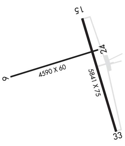
| Rwy | Rwy | |||||||
| 4590x60 | 4590' | 4590x60 | 4590' | |||||
| 5841x75 | 5655' | 5841x75 | 5659' | |||||
| Runway ID | Single Wheel | Double Wheel | Double Tandem Wheel | Dual Double Wheel |
| 06/24 | N/A | N/A | N/A | N/A |
| 15/33 | 50,000 | 75,000 | N/A | N/A |
| These numbers are Advisory and are not limits. The Airport Manager should have more accurate Weight Limits | ||||
 Airport Diagram might not be current. | |
| Facility Name: | SOCORRO MUNI |
| City Name: | SOCORRO |
| County: | SOCORRO |
| State abbrev: | NM |
| State Name: | NEW MEXICO |
| Ownership: | PUBLICLY OWNED |
| Use: | OPEN TO THE PUBLIC |
| Owner's Name: | CITY OF SOCORRO |
| Address: | PO BOX K |
| SOCORRO, NM 87801 | |
| Owner's Phone: | 575-835-2490 |
| Manager's Name: | ISAAC ANGEL; EMAIL: IANGEL@SOCORRONM.GOV |
| Address: | PO BOX K |
| SOCORRO, NM 87801 | |
| Phone: | (505) 507-2800 |
| FAA Region: | SOUTHWEST |
| FAA Field Office: | LNM |
| Date | Sunrise | Sunset |
|---|---|---|
| 09/24/21 Friday | 6:57 | 19:02 |
| 09/25/21 Saturday | 6:58 | 19:00 |
| 09/26/21 Sunday | 6:58 | 18:59 |
| 09/27/21 Monday | 6:59 | 18:58 |
| 09/28/21 Tuesday | 7:00 | 18:56 |
| 09/29/21 Wednesday | 7:00 | 18:55 |
| 09/30/21 Thursday | 7:01 | 18:53 |
| 10/01/21 Friday | 7:02 | 18:52 |
| 10/02/21 Saturday | 7:03 | 18:51 |
| 10/03/21 Sunday | 7:03 | 18:49 |
| 10/04/21 Monday | 7:04 | 18:48 |
| 10/05/21 Tuesday | 7:05 | 18:47 |
| 10/06/21 Wednesday | 7:06 | 18:45 |
| 10/07/21 Thursday | 7:06 | 18:44 |
| Airport Attendance Schedule | UNATTENDED; FOR EMERG CALL 505-507-2800. |
| Airport Status | OPERATIONAL (This Status can change at any time - please check NOTAMS) |
| Airport Lighting Schedule | MIRL RWY 15/33 PRESET LOW INTST; TO INCR INTST & ACTVT VASI RWY 15; PAPI RWY 33; MIRL RWY 06/24 - CTAF. |
| Airport Storage Available | Tie Downs |
| Extra Services Available | Air Ambulance, Flight Instruction |
| Wind Indicator | YES - (lighted) |
| Control Tower | NO |
| CTAF Frequency | 122.800 |
| Unicom Frequency | 122.800 |
| Rotating Beacon Color | CLEAR-GREEN (Light Land Airport) |
| Segmented Circle | YES |
| Landing Fee | NO |
| Airport Inspected | STATE - performed by PRIVATE CONTRACT PERSONNEL |
| Inspection Date | 03/25/2020 |
| Type of Fuel Available | Grade 100LL; -10100LL AVBL 24 HOURS WITH MAJOR CREDIT CARD. |
| Airframe Repair Service | None |
| Power Plant Repair Service | None |
| Latitude | N3401.3 |
| Longitude | W10654.2 (ESTIMATED) |
| Arpt Elevation | 4875ft (SURVEYED) |
| Magnetic Variation | 09E |
| 3 miles S | of SOCORRO |
| Traffic Pattern Altitude | |
| Sectional Chart | ALBUQUERQUE |
| Operations (Reported) | Yearly | Avg. Daily |
|---|---|---|
| General Aviation Transient | 2000 | 5 |
| General Aviation Local | 2500 | 7 |
| Air Taxi | 0 | 0 |
| Commerical | 0 | 0 |
| Commuter | 0 | 0 |
| Military | 100 | 0 |
| Aircraft based on Field | |
|---|---|
| General Aviation Singles | 12 |
| General Aviation Multi | 0 |
| Jet Aircraft | 0 |
| General Aviation Helicopters | 1 |
| Military Aircraft | 0 |
| Gliders | 0 |
| Ultralights | 0 |
| FSS on field | NO |
| FSS tie-in | ALBUQUERQUE |
| FSS Phone | 1-800-WX-BRIEF |
| Who issues Notams | ABQ |
| Notam D service at airport | YES |
| ARTCC Name | ALBUQUERQUE |
| Airport Certification | |
| Aircraft Rescue & Firefighting Index | None |
| Airport of Entry | No |
| Custom Landing Rights | No |
| Joint Civil/Military | No |
| Military Landing rights | YES |
| NATIONAL PLAN OF INTEGRATED AIRPORT SYSTEMS (NPIAS) |
| GRANT AGREEMENTS UNDER FAAP/ADAP/AIP |
| CONVEYANCE UNDER SCETION 16, FEDERAL AIRPORT ACT OF 1946 OR SECTION 23, AIRPORT AND AIRWAY DEVELOPMENT ACT OF 1970 |
| ASSURANCES PURSUANT TO TITLE VI, CIVIL RIGHTS ACT OF 1964 |
| AGREEMENT UNDER DLAND OR DCLA HAS EXPIRED. |
| THIS AIRPORT HAS BEEN SURVEYED BY THE NATIONAL GEODETIC SURVEY. |
| GATE CODE 4850. |
| RY 15/33 +4-7 FT BRUSH IN PRIMARY SFC 70 FT FM CNTRLN WEST SIDE, 95 FT FM CNTRLN EAST SIDE. |
| RY 06/24 +4-8 FT BRUSH IN PRIMARY SFC 50 FT FM CNTRLN SOUTH SIDE. |
| FOR CD CTC ALBUQUERQUE ARTCC AT 505-856-4561. |
Airport Communications & Frequencies:
| |||||||||
| Runway: 06 | Runway: 24 | ||
| Mag heading: | 65° | Mag heading: | 245° |
| Rwy Slope: | -1.96% Down | Rwy Slope: | 1.96% Up |
| Approach: | Approach: | ||
| Pattern: | Left Traffic | Pattern: | Left Traffic |
| Markings: | BASIC | Markings: | BASIC |
| Marking Condition: | GOOD | Marking Condition: | GOOD |
| Arresting Dev: | Arresting Dev: | ||
| Lat & Long: | N3401.3 W10654.9 | Lat. & Long.: | N3401.5 W10654.0 |
| Elev: | 4875.2 ft. MSL | Elev: | 4785.4 ft. MSL |
| TCH: | TCH: | ||
| Visual Glide Path: | Visual Glide Path: | ||
| Displaced Threshold: | No | Displaced Threshold: | No |
| Touchdown Zone: | YES | Touchdown Zone: | YES |
| Touchdown Elev.: | 4875.2 feet | Touchdown Elev.: | 4843.6 feet |
| Visual Glide Slope: | Visual Glide Slope: | ||
| RVR Equipment: | RVR Equipment: | ||
| RVV Equipment: | NO | RVV Equipment: | NO |
| Approach Lights: | Approach Lights: | ||
| REIL: | NO | REIL: | NO |
| Centerline Lights: | NO | Centerline Lights: | NO |
| Touchdown lights: | NO | Touchdown lights: | NO |
| Runway Category: | Runway with a Visual Approach | Runway Category: | Runway with a Visual Approach |
| Declared Distances: | Declared Distances: | ||
| Comments: | Comments: | RWY 24 +3 FT SCATTERED BRUSH 0 FT FM THLD, 80 FT RIGHT OF CNTRLN, 105-125 FT LEFT OF CENTERLINE |
| Runway: 15 | Runway: 33 | ||
| Mag heading: | 155° | Mag heading: | 335° |
| Rwy Slope: | -.93% Down | Rwy Slope: | .93% Up |
| Approach: | Approach: | ||
| Pattern: | Left Traffic | Pattern: | Left Traffic |
| Markings: | NONPRECISION INSTRUMENT | Markings: | NONPRECISION INSTRUMENT |
| Marking Condition: | POOR; RWY 15 MARKINGS FADED. | Marking Condition: | POOR; RWY 33 MARKINGS FADED. |
| Arresting Dev: | Arresting Dev: | ||
| Lat & Long: | N3401.8 W10654.2 | Lat. & Long.: | N3400.8 W10653.8 |
| Elev: | 4798.5 ft. MSL | Elev: | 4744.2 ft. MSL |
| TCH: | 25 ft. AGL | TCH: | 26 ft. AGL |
| Visual Glide Path: | 4.00 degrees | Visual Glide Path: | 4.00 degrees |
| Displaced Threshold: | 186 feet | Displaced Threshold: | 182 feet |
| Touchdown Zone: | YES | Touchdown Zone: | YES |
| Touchdown Elev.: | 4798.5 feet | Touchdown Elev.: | 4782.0 feet |
| Visual Glide Slope: | 2-Box VASI on LEFT side of Runway | Visual Glide Slope: | 2-Light PAPI on LEFT side of Runway |
| RVR Equipment: | RVR Equipment: | ||
| RVV Equipment: | NO | RVV Equipment: | NO |
| Approach Lights: | Approach Lights: | ||
| REIL: | NO | REIL: | NO |
| Centerline Lights: | NO | Centerline Lights: | NO |
| Touchdown lights: | NO | Touchdown lights: | NO |
| Runway Category: | Runway with a Visual Approach | Runway Category: | Runway with a Non-precision Approach having visibility minimums greater than 3/4 mile |
| Declared Distances: | Declared Distances: | ||
| Comments: | RWY 15 +3FT FENCE 80 FT FM THLD, 45 FT LEFT AND RIGHT OF CNTRLN. -40 FT DROPOFF 80 FT FM THLD LEFT AND RIGHT OF CNTRLN. | Comments: | RY 33 +4 FT BRUSH 10-100 FT FM THR LEFT AND RIGHT OF CNTRLN; -20FT DROPOFF 100 FT FM THR. |
Thanks for using FltPlan.com
all rights reserved © 1999-2021 by Flight Plan LLC
