
| WINONA MUNI-MAX CONRAD FLD WINONA MN |
| |
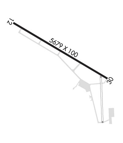
| Lat: N 4404.8 Long: W 09142.7 Elev: 656 Var: +01 Longest Runway: 5679 | ||
| AWOS: 111.4 CTAF: 122.8 | ||
| ||||||||||||||||||||||||||||||||||||||||||||
| ||||||||||||||||||||||||||||||||||||||||||||
| ||||||||||||||||||||||||||||||||||||||||||||
| Rwy | Rwy | |||||||
| 5679x100 | 5679' | 5679x100 | 5199' | 109.35 - 300° | ||||
| Runway ID | Single Wheel | Double Wheel | Double Tandem Wheel | Dual Double Wheel |
| 12/30 | 30,000 | 55,000 | N/A | N/A |
| These numbers are Advisory and are not limits. The Airport Manager should have more accurate Weight Limits | ||||
 Airport Diagram might not be current. | |
| Facility Name: | WINONA MUNI/MAX CONRAD FLD |
| City Name: | WINONA |
| County: | WINONA |
| State abbrev: | MN |
| State Name: | MINNESOTA |
| Ownership: | PUBLICLY OWNED |
| Use: | OPEN TO THE PUBLIC |
| Owner's Name: | CITY OF WINONA |
| Address: | BOX 378 |
| WINONA, MN 55987 | |
| Owner's Phone: | 507-457-8269 |
| Manager's Name: | BRIAN DEFRANG |
| Address: | BOX 378 |
| WINONA, MN 55987 | |
| Phone: | 507-457-8269 |
| FAA Region: | GREAT LAKES |
| FAA Field Office: | DMA |
| Date | Sunrise | Sunset |
|---|---|---|
| 06/08/26 Monday | 5:24 | 20:48 |
| 06/09/26 Tuesday | 5:24 | 20:49 |
| 06/10/26 Wednesday | 5:24 | 20:49 |
| 06/11/26 Thursday | 5:23 | 20:50 |
| 06/12/26 Friday | 5:23 | 20:50 |
| 06/13/26 Saturday | 5:23 | 20:51 |
| 06/14/26 Sunday | 5:23 | 20:51 |
| 06/15/26 Monday | 5:23 | 20:52 |
| 06/16/26 Tuesday | 5:23 | 20:52 |
| 06/17/26 Wednesday | 5:23 | 20:52 |
| 06/18/26 Thursday | 5:23 | 20:53 |
| 06/19/26 Friday | 5:23 | 20:53 |
| 06/20/26 Saturday | 5:23 | 20:53 |
| 06/21/26 Sunday | 5:24 | 20:54 |
| Airport Attendance Schedule | MON-FRI 0700-1630 |
| Airport Status | OPERATIONAL (This Status can change at any time - please check NOTAMS) |
| Airport Lighting Schedule | MIRL RY 12/30 PRESET ON LOW INTST, TO INCR INTST & ACTVT MALSR RY 30; REIL RY 12; PAPI RY 12/30; MIRL RY 12/30 - CTAF. |
| Airport Storage Available | Tie Downs, Hanger |
| Extra Services Available | Charter, Flight Instruction, Aircraft Rental, Aircraft Sales, Annual Surveying |
| Wind Indicator | YES - (lighted) |
| Control Tower | NO |
| CTAF Frequency | 122.800 |
| Unicom Frequency | 122.800 |
| Rotating Beacon Color | WG |
| Segmented Circle | NO |
| Landing Fee | NO |
| Airport Inspected | STATE - performed by STATE AERONAUTICAL PERSONNEL |
| Inspection Date | 07/11/2025 |
| Type of Fuel Available | Grade 100LL, JET A (freeze point -40C); -10FOR SVC AFT HRS CALL 507-429-6321 OR 507-313-8720. |
| Airframe Repair Service | MAJOR |
| Power Plant Repair Service | MAJOR |
| Latitude | N4404.8 |
| Longitude | W09142.7 (ESTIMATED) |
| Arpt Elevation | 656ft (SURVEYED) |
| Magnetic Variation | 01W |
| 3 miles NW | of WINONA |
| Traffic Pattern Altitude | |
| Sectional Chart | GREEN BAY |
| Operations (Reported) | Yearly | Avg. Daily |
|---|---|---|
| General Aviation Transient | 0 | 0 |
| General Aviation Local | 0 | 0 |
| Air Taxi | 0 | 0 |
| Commerical | 0 | 0 |
| Commuter | 0 | 0 |
| Military | 0 | 0 |
| Aircraft based on Field | |
|---|---|
| General Aviation Singles | 0 |
| General Aviation Multi | 0 |
| Jet Aircraft | 0 |
| General Aviation Helicopters | 0 |
| Military Aircraft | 0 |
| Gliders | 0 |
| Ultralights | 0 |
| FSS on field | NO |
| FSS tie-in | PRINCETON |
| FSS Phone | 1-800-WX-BRIEF |
| Who issues Notams | ONA |
| Notam D service at airport | YES |
| ARTCC Name | MINNEAPOLIS |
| Airport Certification | |
| Aircraft Rescue & Firefighting Index | None |
| Airport of Entry | No |
| Custom Landing Rights | No |
| Joint Civil/Military | No |
| Military Landing rights | YES |
| NATIONAL PLAN OF INTEGRATED AIRPORT SYSTEMS (NPIAS) |
| GRANT AGREEMENTS UNDER FAAP/ADAP/AIP |
| ASSURANCES PURSUANT TO TITLE VI, CIVIL RIGHTS ACT OF 1964 |
| DEER AND WATERFOWL ON AND INVOF ARPT. |
| FOR CD IF UNA TO CTC ON FSS FREQ, CTC MINNEAPOLIS ARTCC AT 651-463-5588. |
| COLD TEMPERATURE AIRPORT. ALTITUDE CORRECTION REQUIRED AT OR BELOW -29C. |
| RWY 12/3 0 RUNWAY 30 IS CALM WIND RUNWAY |
Airport Communications & Frequencies:
| |||||||||
| Runway: 12 | Runway: 30 | ||
| Mag heading: | 120° | Mag heading: | 300° |
| Rwy Slope: | .00% Down | Rwy Slope: | .00% Up |
| Approach: | Approach: | ILS/DME | |
| Pattern: | Left Traffic | Pattern: | Right Traffic |
| Markings: | PRECISION INSTRUMENT | Markings: | PRECISION INSTRUMENT |
| Marking Condition: | FAIR | Marking Condition: | FAIR |
| Arresting Dev: | Arresting Dev: | ||
| Lat & Long: | N4405.0 W09143.3 | Lat. & Long.: | N4404.5 W09142.1 |
| Elev: | 656.2 ft. MSL | Elev: | 656.1 ft. MSL |
| TCH: | 42 ft. AGL | TCH: | 50 ft. AGL |
| Visual Glide Path: | 3.00 degrees | Visual Glide Path: | 3.00 degrees |
| Displaced Threshold: | No | Displaced Threshold: | 480 feet |
| Touchdown Zone: | YES | Touchdown Zone: | YES |
| Touchdown Elev.: | 656.2 feet | Touchdown Elev.: | 656.2 feet |
| Visual Glide Slope: | 4-Light PAPI on LEFT side of Runway | Visual Glide Slope: | 4-Light PAPI on LEFT side of Runway |
| RVR Equipment: | RVR Equipment: | ||
| RVV Equipment: | NO | RVV Equipment: | NO |
| Approach Lights: | Approach Lights: | MALSR - 1,400 foot medium intensity approach lighting system with runway alignment indicator lights | |
| REIL: | YES | REIL: | NO |
| Centerline Lights: | NO | Centerline Lights: | NO |
| Touchdown lights: | NO | Touchdown lights: | NO |
| Runway Category: | Runway with a Non-precision Approach having visibility minimums greater than 3/4 mile | Runway Category: | Precision Instrument Runway |
| Declared Distances: | TORA:5679' TODA:5679' ASDA:5199' LDA:5199' | Declared Distances: | TORA:5679' TODA:5679' ASDA:5679' LDA:5199' |
Thanks for using FltPlan.com
all rights reserved © 1999-2026 by Flight Plan LLC
