
| COLUMBUS MUNI COLUMBUS NE |
| |
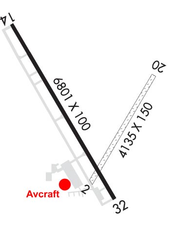
| Lat: N 4126.9 Long: W 09720.5 Elev: 1447 Var: -03 Longest Runway: 6801 | ||
| AWOS: 125.52 CTAF: 123.05 | ||
| ||||||||||||||||||||||||||||||||||||||||||||||||||||||||||||||||||||
| ||||||||||||||||||||||||||||||||||||||||||||||||||||||||||||||||||||
| ||||||||||||||||||||||||||||||||||||||||||||||||||||||||||||||||||||
| Rwy | Rwy | |||||||
| 4135x150 | 4034' | 4135x150 | 4135' | |||||
| 6801x100 | 6801' | 109.10 - 146° | 6801x100 | 5851' | ||||
| Runway ID | Single Wheel | Double Wheel | Double Tandem Wheel | Dual Double Wheel |
| 02/20 | N/A | N/A | N/A | N/A |
| 14/32 | 43,000 | 58,000 | N/A | N/A |
| These numbers are Advisory and are not limits. The Airport Manager should have more accurate Weight Limits | ||||
 Airport Diagram might not be current. | |
| Facility Name: | COLUMBUS MUNI |
| City Name: | COLUMBUS |
| County: | PLATTE |
| State abbrev: | NE |
| State Name: | NEBRASKA |
| Ownership: | PUBLICLY OWNED |
| Use: | OPEN TO THE PUBLIC |
| Owner's Name: | CITY OF COLUMBUS |
| Address: | P.O. BOX 1677 |
| COLUMBUS, NE 68602-1677 | |
| Owner's Phone: | 402-562-4227; JANELLE KLINE, CITY CLERK |
| Manager's Name: | ROSS NIEDBALSKI |
| Address: | PO BOX 1677, 1308 BILL BABKA DRIVE, 2765 14TH AVE |
| COLUMBUS, NE 68602-1677 | |
| Phone: | 402-276-5284 |
| FAA Region: | CENTRAL |
| FAA Field Office: | NONE |
| Date | Sunrise | Sunset |
|---|---|---|
| 06/08/26 Monday | 5:56 | 21:01 |
| 06/09/26 Tuesday | 5:56 | 21:02 |
| 06/10/26 Wednesday | 5:55 | 21:02 |
| 06/11/26 Thursday | 5:55 | 21:03 |
| 06/12/26 Friday | 5:55 | 21:03 |
| 06/13/26 Saturday | 5:55 | 21:04 |
| 06/14/26 Sunday | 5:55 | 21:04 |
| 06/15/26 Monday | 5:55 | 21:05 |
| 06/16/26 Tuesday | 5:55 | 21:05 |
| 06/17/26 Wednesday | 5:55 | 21:05 |
| 06/18/26 Thursday | 5:55 | 21:06 |
| 06/19/26 Friday | 5:55 | 21:06 |
| 06/20/26 Saturday | 5:56 | 21:06 |
| 06/21/26 Sunday | 5:56 | 21:06 |
| Airport Attendance Schedule | 7 Days A Week DALGT; FOR SVC AFT DARK CALL (402) 564-7884. |
| Airport Status | OPERATIONAL (This Status can change at any time - please check NOTAMS) |
| Airport Lighting Schedule | ACTVT MIRL RY 14/32; PAPI RY 14; VASI RY 32; REIL RY 32 & MALSR RY 14 - CTAF. |
| Airport Storage Available | Tie Downs, Hanger |
| Extra Services Available | Air Freight, Flight Instruction, Aircraft Rental |
| Wind Indicator | YES - (lighted) |
| Control Tower | NO |
| CTAF Frequency | 123.050 |
| Unicom Frequency | 123.050 |
| Rotating Beacon Color | WG |
| Segmented Circle | YES |
| Landing Fee | NO |
| Airport Inspected | FEDERAL - performed by STATE AERONAUTICAL PERSONNEL |
| Inspection Date | 07/26/2023 |
| Type of Fuel Available | Grade 100LL, JET A (freeze point -40C); -10FOR FUEL AFT HRS CONTACT 402-910-5246. |
| Airframe Repair Service | MAJOR |
| Power Plant Repair Service | MAJOR |
| Latitude | N4126.9 |
| Longitude | W09720.5 (ESTIMATED) |
| Arpt Elevation | 1447ft (SURVEYED) |
| Magnetic Variation | 03E |
| 1 miles NE | of COLUMBUS |
| Traffic Pattern Altitude | |
| Sectional Chart | OMAHA |
| Operations (Reported) | Yearly | Avg. Daily |
|---|---|---|
| General Aviation Transient | 0 | 0 |
| General Aviation Local | 0 | 0 |
| Air Taxi | 0 | 0 |
| Commerical | 0 | 0 |
| Commuter | 0 | 0 |
| Military | 0 | 0 |
| Aircraft based on Field | |
|---|---|
| General Aviation Singles | 0 |
| General Aviation Multi | 0 |
| Jet Aircraft | 0 |
| General Aviation Helicopters | 0 |
| Military Aircraft | 0 |
| Gliders | 0 |
| Ultralights | 0 |
| FSS on field | NO |
| FSS tie-in | COLUMBUS |
| FSS Phone | 1-800-WX-BRIEF |
| Who issues Notams | OLU |
| Notam D service at airport | YES |
| ARTCC Name | MINNEAPOLIS |
| Airport Certification | |
| Aircraft Rescue & Firefighting Index | None |
| Airport of Entry | No |
| Custom Landing Rights | No |
| Joint Civil/Military | No |
| Military Landing rights | YES |
| NATIONAL PLAN OF INTEGRATED AIRPORT SYSTEMS (NPIAS) |
| GRANT AGREEMENTS UNDER FAAP/ADAP/AIP |
| ASSURANCES PURSUANT TO TITLE VI, CIVIL RIGHTS ACT OF 1964 |
| WATERFOWL INVOF ARPT. |
| DEER INVOF ARPT. |
| RY 32 IS DESIGNATED AS THE CALM WIND RY. |
| FOR CD IF UNA TO CTC ON FSS FREQ, CTC MINNEAPOLIS ARTCC AT 651-463-5588. |
| RWY 02/2 0 RY 02/20 NOT PLOWED WINTER MONTHS. |
Airport Communications & Frequencies:
| |||||||||
| Runway: 02 | Runway: 20 | ||
| Mag heading: | 27° | Mag heading: | 207° |
| Rwy Slope: | -.03% Down | Rwy Slope: | .03% Up |
| Approach: | Approach: | ||
| Pattern: | Left Traffic | Pattern: | Left Traffic |
| Markings: | Markings: | ||
| Marking Condition: | BOUNDARY MARKERS-G. | Marking Condition: | |
| Arresting Dev: | Arresting Dev: | ||
| Lat & Long: | N4126.6 W09720.4 | Lat. & Long.: | N4127.2 W09720.0 |
| Elev: | 1440.9 ft. MSL | Elev: | 1439.5 ft. MSL |
| TCH: | TCH: | ||
| Visual Glide Path: | Visual Glide Path: | ||
| Displaced Threshold: | 101 feet; RWY 02 END CONES MARK DSPLCD THLD; NOT RWY END. | Displaced Threshold: | No |
| Touchdown Zone: | YES | Touchdown Zone: | YES |
| Touchdown Elev.: | 1441.6 feet | Touchdown Elev.: | 1441.1 feet |
| Visual Glide Slope: | Visual Glide Slope: | ||
| RVR Equipment: | RVR Equipment: | ||
| RVV Equipment: | NO | RVV Equipment: | NO |
| Approach Lights: | Approach Lights: | ||
| REIL: | NO | REIL: | NO |
| Centerline Lights: | NO | Centerline Lights: | NO |
| Touchdown lights: | NO | Touchdown lights: | NO |
| Runway Category: | Runway with a Visual Approach | Runway Category: | Runway with a Visual Approach |
| Declared Distances: | Declared Distances: | ||
| Obstructions: | RWY 02 CLNC SLOPE 30:1 DUE TO GRAIN ELEVATOR LEG 116 FT ABV RWY END 3491 FT FROM DSPLCD THLD; RWY 20 CTR PIVOT THRU APCH DURING IRRIGATION SEASON. | Obstructions: | |
| Marked: | NOT Marked/Lighted | Marked: | |
| Clearance slope: | 20:1 | Clearance slope: | 20:1 |
| Obstruction height: | Obstruction height: | ||
| Dist. from runway: | Dist. from runway: | ||
| Centerline offset: | Centerline offset: | ||
| Comments: | Comments: |
| Runway: 14 | Runway: 32 | ||
| Mag heading: | 147° | Mag heading: | 327° |
| Rwy Slope: | -.10% Down | Rwy Slope: | .10% Up |
| Approach: | LOCALIZER | Approach: | |
| Pattern: | Left Traffic | Pattern: | Left Traffic |
| Markings: | PRECISION INSTRUMENT | Markings: | PRECISION INSTRUMENT |
| Marking Condition: | GOOD | Marking Condition: | GOOD |
| Arresting Dev: | Arresting Dev: | ||
| Lat & Long: | N4127.4 W09721.0 | Lat. & Long.: | N4126.5 W09720.2 |
| Elev: | 1447.3 ft. MSL | Elev: | 1440.5 ft. MSL |
| TCH: | 40 ft. AGL | TCH: | 44 ft. AGL |
| Visual Glide Path: | 3.00 degrees | Visual Glide Path: | 3.00 degrees |
| Displaced Threshold: | No | Displaced Threshold: | 950 feet |
| Touchdown Zone: | YES | Touchdown Zone: | YES |
| Touchdown Elev.: | 1447.3 feet | Touchdown Elev.: | 1443.3 feet |
| Visual Glide Slope: | 4-Light PAPI on LEFT side of Runway | Visual Glide Slope: | 4-BOX VASI ON LEFT SIDE OF RUNWAY |
| RVR Equipment: | RVR Equipment: | ||
| RVV Equipment: | NO | RVV Equipment: | NO |
| Approach Lights: | MALSR - 1,400 foot medium intensity approach lighting system with runway alignment indicator lights | Approach Lights: | |
| REIL: | NO | REIL: | YES |
| Centerline Lights: | NO | Centerline Lights: | NO |
| Touchdown lights: | NO | Touchdown lights: | NO |
| Runway Category: | D | Runway Category: | D |
| Declared Distances: | TORA:6800' TODA:6800' ASDA:6260' LDA:6260' | Declared Distances: | TORA:6800' TODA:6800' ASDA:6800' LDA:5850' |
| Obstructions: | Obstructions: | TREE | |
| Marked: | Marked: | NOT Marked/Lighted | |
| Clearance slope: | 34:1; RWY 32 CLNC SLOPE 37:1 TO DSPLCD THR. | Clearance slope: | 17:1 |
| Obstruction height: | Obstruction height: | 60 feet AGL | |
| Dist. from runway: | Dist. from runway: | 1275 feet | |
| Centerline offset: | Centerline offset: | 619 feet right of centerline | |
| Comments: | Comments: |
Thanks for using FltPlan.com
all rights reserved © 1999-2026 by Flight Plan LLC


