
| OLYMPIA RGNL OLYMPIA WA |
| |
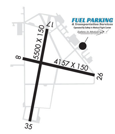
| Lat: N 4658.2 Long: W 12254.2 Elev: 208 Var: -15 Longest Runway: 5500 | ||
| Dept. ATIS: 135.72 Arr. ATIS: 135.72 AWOS: 135.72 Ground: 121.6 Tower: 124.4 | ||
| |||||||||||||||||||||||||||||||||||||||||||||||||||||||||||||||||||||
| |||||||||||||||||||||||||||||||||||||||||||||||||||||||||||||||||||||
| |||||||||||||||||||||||||||||||||||||||||||||||||||||||||||||||||||||
| |||||||||||||||||||||||||||||||||||||||||||||||||||||||||||||||||||||
| Rwy | Rwy | |||||||
| 4157x150 | 4157' | 4157x150 | 4157' | |||||
| 5500x150 | 5500' | 111.90 - 176° | 5500x150 | 5500' | ||||
| Runway ID | Single Wheel | Double Wheel | Double Tandem Wheel | Dual Double Wheel |
| 08/26 | 30,000 | N/A | N/A | N/A |
| 17/35 | 75,000 | 94,000 | 142,000 | N/A |
| These numbers are Advisory and are not limits. The Airport Manager should have more accurate Weight Limits | ||||
 Airport Diagram might not be current. | |
| Facility Name: | OLYMPIA RGNL |
| City Name: | OLYMPIA |
| County: | THURSTON |
| State abbrev: | WA |
| State Name: | WASHINGTON |
| Ownership: | PUBLICLY OWNED |
| Use: | OPEN TO THE PUBLIC |
| Owner's Name: | PORT OF OLYMPIA |
| Address: | 606 COLUMBIA ST NW, SUITE 300 |
| OLYMPIA, WA 98501-0827 | |
| Owner's Phone: | 360-528-8000 |
| Manager's Name: | RUDY RUDOLPH |
| Address: | 7643 OLD HWY 99 SE |
| OLYMPIA, WA 98501 | |
| Phone: | 360-528-8074 |
| FAA Region: | NORTHWEST MOUNTAIN |
| FAA Field Office: | SEA |
| Date | Sunrise | Sunset |
|---|---|---|
| 09/24/21 Friday | 7:01 | 19:06 |
| 09/25/21 Saturday | 7:02 | 19:04 |
| 09/26/21 Sunday | 7:04 | 19:01 |
| 09/27/21 Monday | 7:05 | 18:59 |
| 09/28/21 Tuesday | 7:06 | 18:57 |
| 09/29/21 Wednesday | 7:08 | 18:55 |
| 09/30/21 Thursday | 7:09 | 18:53 |
| 10/01/21 Friday | 7:10 | 18:52 |
| 10/02/21 Saturday | 7:12 | 18:50 |
| 10/03/21 Sunday | 7:13 | 18:48 |
| 10/04/21 Monday | 7:14 | 18:46 |
| 10/05/21 Tuesday | 7:16 | 18:44 |
| 10/06/21 Wednesday | 7:17 | 18:42 |
| 10/07/21 Thursday | 7:18 | 18:40 |
| Airport Attendance Schedule | 7 Days A Week 0800-1800 |
| Airport Status | OPERATIONAL (This Status can change at any time - please check NOTAMS) |
| Airport Lighting Schedule | WHEN ATCT CLSD ACTVT HIRL RY 17/35; MALSR 17; REIL RY 35, TWY LGTS & DIRECTIONAL SIGNAGE - CTAF. PAPI RYS 17 & 35 OPER CONT. |
| Airport Storage Available | Tie Downs, Hanger |
| Extra Services Available | Air Ambulance, Avionics, Charter, Flight Instruction, Aircraft Rental |
| Wind Indicator | YES - (lighted) |
| Control Tower | YES |
| CTAF Frequency | 124.400 |
| Unicom Frequency | 122.950 |
| Rotating Beacon Color | CLEAR-GREEN (Light Land Airport) |
| Segmented Circle | YES |
| Landing Fee | YES |
| Airport Inspected | FEDERAL - performed by STATE AERONAUTICAL PERSONNEL |
| Inspection Date | 10/07/2020 |
| Type of Fuel Available | Grade 100LL, JET A (freeze point -40C) |
| Airframe Repair Service | MAJOR |
| Power Plant Repair Service | MAJOR |
| Latitude | N4658.2 |
| Longitude | W12254.2 (ESTIMATED) |
| Arpt Elevation | 207ft (ESTIMATED) |
| Magnetic Variation | 15E |
| 4 miles S | of OLYMPIA |
| Traffic Pattern Altitude | |
| Sectional Chart | SEATTLE |
| Operations (Reported) | Yearly | Avg. Daily |
|---|---|---|
| General Aviation Transient | 27884 | 76 |
| General Aviation Local | 33272 | 91 |
| Air Taxi | 940 | 3 |
| Commerical | 0 | 0 |
| Commuter | 0 | 0 |
| Military | 1098 | 3 |
| Aircraft based on Field | |
|---|---|
| General Aviation Singles | 96 |
| General Aviation Multi | 8 |
| Jet Aircraft | 3 |
| General Aviation Helicopters | 18 |
| Military Aircraft | 0 |
| Gliders | 0 |
| Ultralights | 0 |
| FSS on field | NO |
| FSS tie-in | SEATTLE |
| FSS Phone | 1-800-WX-BRIEF |
| Who issues Notams | OLM |
| Notam D service at airport | YES |
| ARTCC Name | SEATTLE |
| Airport Certification | |
| Aircraft Rescue & Firefighting Index | None |
| Airport of Entry | No |
| Custom Landing Rights | YES |
| Joint Civil/Military | No |
| Military Landing rights | YES |
| NATIONAL PLAN OF INTEGRATED AIRPORT SYSTEMS (NPIAS) |
| GRANT AGREEMENTS UNDER FAAP/ADAP/AIP |
| SURPLUS PROPERTY AGREEMENT UNDER PUBLIC LAW 289 |
| ASSURANCES PURSUANT TO TITLE VI, CIVIL RIGHTS ACT OF 1964 |
| AGREEMENT UNDER DLAND OR DCLA HAS EXPIRED. |
| TWY LGTS ON TWY W, A, L, AND B. |
| AIRPORT FIELD CONDITIONS UNMONITORED 1700 LCL - 0700 LCL. |
| EMERG FREQ 121.5 NOT MNT AT TWR. |
| FOR CD WHEN ATCT IS CLSD CTC SEATTLE APCH AT 206-214-4723. |
Airport Communications & Frequencies:
| |||||||||||||||||||||||||
| Runway: 08 | Runway: 26 | ||
| Mag heading: | 89° | Mag heading: | 269° |
| Rwy Slope: | .24% Up | Rwy Slope: | -.24% Down |
| Approach: | Approach: | ||
| Pattern: | Right Traffic | Pattern: | Left Traffic |
| Markings: | BASIC | Markings: | BASIC |
| Marking Condition: | GOOD | Marking Condition: | GOOD |
| Arresting Dev: | Arresting Dev: | ||
| Lat & Long: | N4658.3 W12254.5 | Lat. & Long.: | N4658.1 W12253.5 |
| Elev: | 194.1 ft. MSL | Elev: | 204.1 ft. MSL |
| TCH: | TCH: | ||
| Visual Glide Path: | Visual Glide Path: | ||
| Displaced Threshold: | No | Displaced Threshold: | No |
| Touchdown Zone: | YES | Touchdown Zone: | YES |
| Touchdown Elev.: | 201.5 feet | Touchdown Elev.: | 205.3 feet |
| Visual Glide Slope: | Visual Glide Slope: | ||
| RVR Equipment: | RVR Equipment: | ||
| RVV Equipment: | NO | RVV Equipment: | NO |
| Approach Lights: | Approach Lights: | ||
| REIL: | NO | REIL: | NO |
| Centerline Lights: | NO | Centerline Lights: | NO |
| Touchdown lights: | NO | Touchdown lights: | NO |
| Runway Category: | Runway with a Visual Approach | Runway Category: | Runway with a Visual Approach |
| Declared Distances: | Declared Distances: | ||
| Obstructions: | TREES | Obstructions: | TREE |
| Marked: | NOT Marked/Lighted | Marked: | NOT Marked/Lighted |
| Clearance slope: | 20:1 | Clearance slope: | 7:1 |
| Obstruction height: | 58 feet AGL | Obstruction height: | 107 feet AGL |
| Dist. from runway: | 1360 feet | Dist. from runway: | 950 feet |
| Centerline offset: | 325 left of centerline | Centerline offset: | 207 feet right of centerline |
| Comments: | Comments: |
| Runway: 17 | Runway: 35 | ||
| Mag heading: | 176° | Mag heading: | 356° |
| Rwy Slope: | .11% Up | Rwy Slope: | -.11% Down |
| Approach: | ILS | Approach: | |
| Pattern: | Left Traffic | Pattern: | Right Traffic |
| Markings: | PRECISION INSTRUMENT | Markings: | NONPRECISION INSTRUMENT |
| Marking Condition: | POOR | Marking Condition: | POOR |
| Arresting Dev: | Arresting Dev: | ||
| Lat & Long: | N4658.6 W12254.1 | Lat. & Long.: | N4657.7 W12254.4 |
| Elev: | 196.6 ft. MSL | Elev: | 202.8 ft. MSL |
| TCH: | 54 ft. AGL | TCH: | 50 ft. AGL |
| Visual Glide Path: | 3.00 degrees | Visual Glide Path: | 3.00 degrees |
| Displaced Threshold: | No | Displaced Threshold: | No |
| Touchdown Zone: | YES | Touchdown Zone: | YES |
| Touchdown Elev.: | 207.3 feet | Touchdown Elev.: | 207.8 feet |
| Visual Glide Slope: | 4-Light PAPI on LEFT side of Runway | Visual Glide Slope: | 4-Light PAPI on LEFT side of Runway |
| RVR Equipment: | RVR Equipment: | ||
| RVV Equipment: | NO | RVV Equipment: | NO |
| Approach Lights: | MALSR - 1,400 foot medium intensity approach lighting system with runway alignment indicator lights | Approach Lights: | |
| REIL: | NO | REIL: | YES |
| Centerline Lights: | NO | Centerline Lights: | NO |
| Touchdown lights: | NO | Touchdown lights: | NO |
| Runway Category: | Precision Instrument Runway | Runway Category: | Runway with a Non-precision Approach having visibility minimums greater than 3/4 mile |
| Declared Distances: | Declared Distances: |
Thanks for using FltPlan.com
all rights reserved © 1999-2021 by Flight Plan LLC


