
| SOLON SPRINGS MUNI SOLON SPRINGS WI |
| |
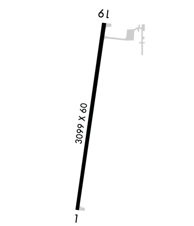
| Lat: N 4618.9 Long: W 09149.0 Elev: 1102 Var: -01 Longest Runway: 3100 | ||
| AWOS: 119.6 CTAF: 122.9 | ||
| ||||||
| ||||||
|
| Rwy | Rwy | |||||||
| 3100x60 | 3100' | 3100x60 | 3100' | |||||
| Runway ID | Single Wheel | Double Wheel | Double Tandem Wheel | Dual Double Wheel |
| 01/19 | 27,000 | N/A | N/A | N/A |
| H1 | N/A | N/A | N/A | N/A |
| These numbers are Advisory and are not limits. The Airport Manager should have more accurate Weight Limits | ||||
 Airport Diagram might not be current. | |
| Facility Name: | SOLON SPRINGS MUNI |
| City Name: | SOLON SPRINGS |
| County: | DOUGLAS |
| State abbrev: | WI |
| State Name: | WISCONSIN |
| Ownership: | PUBLICLY OWNED |
| Use: | OPEN TO THE PUBLIC |
| Owner's Name: | TOWN OF SOLON SPRINGS ARPT COMM; TOWN AND VILLAGE OF SOLON SPRINGS |
| Address: | P.O. BOX 36 |
| SOLON SPRINGS, WI 54873 | |
| Owner's Phone: | 715-378-2235 |
| Manager's Name: | NEIL MATHISON |
| Address: | 11268 S TWIN LAKE RD; EMAIL ADDRESS: SOLONSPRINGSAIRPORT@GMAIL.COM |
| SOLON SPRINGS, WI 54573 | |
| Phone: | (218) 348-3176 |
| FAA Region: | GREAT LAKES |
| FAA Field Office: | CHI |
| Date | Sunrise | Sunset |
|---|---|---|
| 06/12/26 Friday | 5:15 | 21:00 |
| 06/13/26 Saturday | 5:15 | 21:00 |
| 06/14/26 Sunday | 5:15 | 21:01 |
| 06/15/26 Monday | 5:14 | 21:01 |
| 06/16/26 Tuesday | 5:14 | 21:01 |
| 06/17/26 Wednesday | 5:14 | 21:02 |
| 06/18/26 Thursday | 5:15 | 21:02 |
| 06/19/26 Friday | 5:15 | 21:03 |
| 06/20/26 Saturday | 5:15 | 21:03 |
| 06/21/26 Sunday | 5:15 | 21:03 |
| 06/22/26 Monday | 5:15 | 21:03 |
| 06/23/26 Tuesday | 5:15 | 21:03 |
| 06/24/26 Wednesday | 5:16 | 21:03 |
| 06/25/26 Thursday | 5:16 | 21:03 |
| Airport Attendance Schedule | UNATTENDED |
| Airport Status | OPERATIONAL (This Status can change at any time - please check NOTAMS) |
| Airport Lighting Schedule | MIRL RWY 01/19 PRESET TO LOW SS-SR; TO INCR INTST & ACTVT REIL RWY 01 & 19; PAPI RWY 01 & 19; MIRL RWY 01/19; PERI H1 - CTAF. |
| Airport Storage Available | Tie Downs, Hanger |
| Extra Services Available | Flight Instruction |
| Wind Indicator | YES - (lighted) |
| Control Tower | NO |
| CTAF Frequency | 122.900 |
| Unicom Frequency | |
| Rotating Beacon Color | WG |
| Segmented Circle | NO |
| Landing Fee | NO |
| Airport Inspected | STATE - performed by STATE AERONAUTICAL PERSONNEL |
| Inspection Date | 09/20/2024 |
| Type of Fuel Available | Grade 100LL; -1024 HR SELF SVC FUEL AVBL WITH CREDIT CARD. |
| Airframe Repair Service | MINOR; ACFT MECH ON CALL 218-269-2433. |
| Power Plant Repair Service | MINOR |
| Latitude | N4618.9 |
| Longitude | W09149.0 (ESTIMATED) |
| Arpt Elevation | 1102ft (SURVEYED) |
| Magnetic Variation | 01E |
| 3 miles S | of SOLON SPRINGS |
| Traffic Pattern Altitude | |
| Sectional Chart | GREEN BAY |
| Operations (Reported) | Yearly | Avg. Daily |
|---|---|---|
| General Aviation Transient | 0 | 0 |
| General Aviation Local | 0 | 0 |
| Air Taxi | 0 | 0 |
| Commerical | 0 | 0 |
| Commuter | 0 | 0 |
| Military | 0 | 0 |
| Aircraft based on Field | |
|---|---|
| General Aviation Singles | 0 |
| General Aviation Multi | 0 |
| Jet Aircraft | 0 |
| General Aviation Helicopters | 0 |
| Military Aircraft | 0 |
| Gliders | 0 |
| Ultralights | 0 |
| FSS on field | NO |
| FSS tie-in | GREEN BAY |
| FSS Phone | 1-800-WX-BRIEF |
| Who issues Notams | GRB |
| Notam D service at airport | YES |
| ARTCC Name | MINNEAPOLIS |
| Airport Certification | |
| Aircraft Rescue & Firefighting Index | None |
| Airport of Entry | No |
| Custom Landing Rights | No |
| Joint Civil/Military | No |
| Military Landing rights | No |
| NATIONAL PLAN OF INTEGRATED AIRPORT SYSTEMS (NPIAS) |
| NUMEROUS DEER ON ARPT. |
| FOR CD CTC DULUTH APCH AT 218-740-5950. |
| RWY H1 TLOF 40X40 FT, FATO 75X65 FT. |
Airport Communications & Frequencies:
| ||||||||||||
| Runway: 01 | Runway: 19 | ||
| Mag heading: | 7° | Mag heading: | 187° |
| Rwy Slope: | -.03% Down | Rwy Slope: | .03% Up |
| Approach: | Approach: | ||
| Pattern: | Left Traffic | Pattern: | Left Traffic |
| Markings: | NONPRECISION INSTRUMENT | Markings: | NONPRECISION INSTRUMENT |
| Marking Condition: | GOOD | Marking Condition: | GOOD |
| Arresting Dev: | Arresting Dev: | ||
| Lat & Long: | N4618.6 W09149.0 | Lat. & Long.: | N4619.1 W09148.9 |
| Elev: | 1101.2 ft. MSL | Elev: | 1100.4 ft. MSL |
| TCH: | 26 ft. AGL | TCH: | 20 ft. AGL |
| Visual Glide Path: | 3.00 degrees | Visual Glide Path: | 3.50 degrees |
| Displaced Threshold: | No | Displaced Threshold: | No |
| Touchdown Zone: | YES | Touchdown Zone: | YES |
| Touchdown Elev.: | 1102.0 feet | Touchdown Elev.: | 1102.0 feet |
| Visual Glide Slope: | 2-Light PAPI on LEFT side of Runway | Visual Glide Slope: | 2-Light PAPI on LEFT side of Runway |
| RVR Equipment: | RVR Equipment: | ||
| RVV Equipment: | NO | RVV Equipment: | NO |
| Approach Lights: | Approach Lights: | ||
| REIL: | YES | REIL: | YES |
| Centerline Lights: | NO | Centerline Lights: | NO |
| Touchdown lights: | NO | Touchdown lights: | NO |
| Runway Category: | Runway with a Visual Approach | Runway Category: | Runway with a Non-precision Approach |
| Declared Distances: | Declared Distances: |
Thanks for using FltPlan.com
all rights reserved © 1999-2026 by Flight Plan LLC
