| DEWITT FLD,OLD TOWN MUNI OLD TOWN ME |
| |
| Lat: N 4457.1 Long: W 06840.5 Elev: 127 Var: +15 Longest Runway: 4001 | ||
| CTAF: 122.8 | ||
| |||||||||||||||||||||||||||||||||||||||||||||||||||||||||||||
| |||||||||||||||||||||||||||||||||||||||||||||||||||||||||||||
| Rwy | Rwy | |||||||
| 2802x75 | 2802' | 2802x75 | 2802' | |||||
| 4001x75 | 4001' | 4001x75 | 3312' | |||||
| 8400x100 | 8400' | 8400x100 | 8400' | |||||
| Runway ID | Single Wheel | Double Wheel | Double Tandem Wheel | Dual Double Wheel |
| 04/22 | 37,000 | 45,000 | N/A | N/A |
| 12/30 | 30,000 | N/A | N/A | N/A |
| 17W/35W | N/A | N/A | N/A | N/A |
| These numbers are Advisory and are not limits. The Airport Manager should have more accurate Weight Limits | ||||
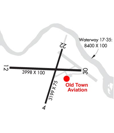 Airport Diagram might not be current. | |
| Facility Name: | DEWITT FLD/OLD TOWN MUNI |
| City Name: | OLD TOWN |
| County: | PENOBSCOT |
| State abbrev: | ME |
| State Name: | MAINE |
| Ownership: | PUBLICLY OWNED |
| Use: | OPEN TO THE PUBLIC |
| Owner's Name: | CITY OF OLD TOWN |
| Address: | 265 MAIN ST |
| OLD TOWN, ME 04468 | |
| Owner's Phone: | 207-827-3965; ALTN CTC: BILL MAYO, CITY MGR 207-827-3965-EXT 201. |
| Manager's Name: | MILES FRANCES |
| Address: | 100 AIRPORT RD, PO BOX 558 |
| OLD TOWN, ME 04468 | |
| Phone: | 207-827-7175 |
| FAA Region: | NEW ENGLAND |
| FAA Field Office: | NONE |
| Date | Sunrise | Sunset |
|---|---|---|
| 06/08/26 Monday | 4:49 | 20:19 |
| 06/09/26 Tuesday | 4:48 | 20:20 |
| 06/10/26 Wednesday | 4:48 | 20:20 |
| 06/11/26 Thursday | 4:48 | 20:21 |
| 06/12/26 Friday | 4:48 | 20:21 |
| 06/13/26 Saturday | 4:48 | 20:22 |
| 06/14/26 Sunday | 4:48 | 20:22 |
| 06/15/26 Monday | 4:47 | 20:23 |
| 06/16/26 Tuesday | 4:47 | 20:23 |
| 06/17/26 Wednesday | 4:48 | 20:24 |
| 06/18/26 Thursday | 4:48 | 20:24 |
| 06/19/26 Friday | 4:48 | 20:24 |
| 06/20/26 Saturday | 4:48 | 20:25 |
| 06/21/26 Sunday | 4:48 | 20:25 |
| Airport Attendance Schedule | 7 Days A Week 0800-1700 |
| Airport Status | OPERATIONAL (This Status can change at any time - please check NOTAMS) |
| Airport Lighting Schedule | ACTVT REIL RWY 04; PAPI RWY 22 & 30; MIRL RWY 04/22 & 12/30 - CTAF. |
| Airport Storage Available | Tie Downs |
| Extra Services Available | Beaching Gear, Flight Instruction, Aircraft Rental, Annual Surveying |
| Wind Indicator | YES - (lighted) |
| Control Tower | NO |
| CTAF Frequency | 122.800 |
| Unicom Frequency | 122.800 |
| Rotating Beacon Color | WG |
| Segmented Circle | Y-L |
| Landing Fee | NO |
| Airport Inspected | STATE - performed by PRIVATE CONTRACT PERSONNEL |
| Inspection Date | 08/12/2025 |
| Type of Fuel Available | Grade 100LL, JET A (freeze point -40C); -1024 HR FUEL WITH CREDIT CARD.; -A SELF SVC FUEL 24 HRS WITH CREDIT CARD. |
| Airframe Repair Service | MAJOR |
| Power Plant Repair Service | MAJOR |
| Latitude | N4457.1 |
| Longitude | W06840.5 (ESTIMATED) |
| Arpt Elevation | 126ft (SURVEYED) |
| Magnetic Variation | 15W |
| 2 miles NW | of OLD TOWN |
| Traffic Pattern Altitude | |
| Sectional Chart | HALIFAX |
| Operations (Reported) | Yearly | Avg. Daily |
|---|---|---|
| General Aviation Transient | 0 | 0 |
| General Aviation Local | 0 | 0 |
| Air Taxi | 0 | 0 |
| Commerical | 0 | 0 |
| Commuter | 0 | 0 |
| Military | 0 | 0 |
| Aircraft based on Field | |
|---|---|
| General Aviation Singles | 0 |
| General Aviation Multi | 0 |
| Jet Aircraft | 0 |
| General Aviation Helicopters | 0 |
| Military Aircraft | 0 |
| Gliders | 0 |
| Ultralights | 0 |
| FSS on field | NO |
| FSS tie-in | BANGOR |
| FSS Phone | 1-800-WX-BRIEF |
| Who issues Notams | BGR |
| Notam D service at airport | YES |
| ARTCC Name | BOSTON |
| Airport Certification | |
| Aircraft Rescue & Firefighting Index | None |
| Airport of Entry | No |
| Custom Landing Rights | No |
| Joint Civil/Military | No |
| Military Landing rights | YES |
| NATIONAL PLAN OF INTEGRATED AIRPORT SYSTEMS (NPIAS) |
| GRANT AGREEMENTS UNDER FAAP/ADAP/AIP |
| ASSURANCES PURSUANT TO TITLE VI, CIVIL RIGHTS ACT OF 1964 |
| AGREEMENT UNDER DLAND OR DCLA HAS EXPIRED. |
| WATERFOWL, TURKEY & DEER ON & INVOF ARPT. |
| FBO CLSD SUN. |
| FOR CD CTC BANGOR APCH AT 207-561-2500 EXTN 1. |
Airport Communications & Frequencies:
| ||||||||||||||
| Runway: 04 | Runway: 22 | ||
| Mag heading: | 37° | Mag heading: | 217° |
| Rwy Slope: | -.13% Down | Rwy Slope: | .13% Up |
| Approach: | Approach: | ||
| Pattern: | Left Traffic | Pattern: | Left Traffic |
| Markings: | NONPRECISION INSTRUMENT | Markings: | NONPRECISION INSTRUMENT |
| Marking Condition: | GOOD | Marking Condition: | GOOD |
| Arresting Dev: | Arresting Dev: | ||
| Lat & Long: | N4456.9 W06840.5 | Lat. & Long.: | N4457.3 W06840.3 |
| Elev: | 125.9 ft. MSL | Elev: | 122.2 ft. MSL |
| TCH: | TCH: | 41 ft. AGL | |
| Visual Glide Path: | Visual Glide Path: | 4.00 degrees | |
| Displaced Threshold: | No | Displaced Threshold: | No |
| Touchdown Zone: | YES | Touchdown Zone: | YES |
| Touchdown Elev.: | 126.5 feet | Touchdown Elev.: | 126.5 feet |
| Visual Glide Slope: | Visual Glide Slope: | 4-Light PAPI on LEFT side of Runway | |
| RVR Equipment: | RVR Equipment: | ||
| RVV Equipment: | NO | RVV Equipment: | NO |
| Approach Lights: | Approach Lights: | ||
| REIL: | YES | REIL: | NO |
| Centerline Lights: | NO | Centerline Lights: | NO |
| Touchdown lights: | NO | Touchdown lights: | NO |
| Runway Category: | Runway with a Visual Approach | Runway Category: | Runway with a Non-precision Approach |
| Declared Distances: | Declared Distances: |
| Runway: 12 | Runway: 30 | ||
| Mag heading: | 112° | Mag heading: | 292° |
| Rwy Slope: | -.14% Down | Rwy Slope: | .14% Up |
| Approach: | Approach: | ||
| Pattern: | Left Traffic | Pattern: | Left Traffic |
| Markings: | NONPRECISION INSTRUMENT | Markings: | NONPRECISION INSTRUMENT |
| Marking Condition: | GOOD | Marking Condition: | GOOD |
| Arresting Dev: | Arresting Dev: | ||
| Lat & Long: | N4457.2 W06841.0 | Lat. & Long.: | N4457.1 W06840.0 |
| Elev: | 124.7 ft. MSL | Elev: | 119.1 ft. MSL |
| TCH: | TCH: | 40 ft. AGL | |
| Visual Glide Path: | Visual Glide Path: | 4.00 degrees | |
| Displaced Threshold: | No | Displaced Threshold: | 689 feet |
| Touchdown Zone: | YES | Touchdown Zone: | YES |
| Touchdown Elev.: | 125.3 feet | Touchdown Elev.: | 125.3 feet |
| Visual Glide Slope: | Visual Glide Slope: | 4-Light PAPI on LEFT side of Runway | |
| RVR Equipment: | RVR Equipment: | ||
| RVV Equipment: | NO | RVV Equipment: | NO |
| Approach Lights: | Approach Lights: | ||
| REIL: | NO | REIL: | NO |
| Centerline Lights: | NO | Centerline Lights: | NO |
| Touchdown lights: | NO | Touchdown lights: | NO |
| Runway Category: | Runway with a Non-precision Approach | Runway Category: | Runway with a Non-precision Approach |
| Declared Distances: | Declared Distances: |
| Runway: 17W | Runway: 35W | ||
| Mag heading: | N/A | Mag heading: | N/A |
| Rwy Slope: | .00% | Rwy Slope: | .00% |
| Approach: | Approach: | ||
| Pattern: | Left Traffic | Pattern: | Left Traffic |
| Markings: | Markings: | ||
| Marking Condition: | Marking Condition: | ||
| Arresting Dev: | Arresting Dev: | ||
| Lat & Long: | Lat. & Long.: | ||
| Elev: | 102.0 ft. MSL | Elev: | 102.0 ft. MSL |
| TCH: | TCH: | ||
| Visual Glide Path: | Visual Glide Path: | ||
| Displaced Threshold: | No | Displaced Threshold: | No |
| Touchdown Zone: | NO | Touchdown Zone: | NO |
| Touchdown Elev.: | Touchdown Elev.: | ||
| Visual Glide Slope: | Visual Glide Slope: | ||
| RVR Equipment: | RVR Equipment: | ||
| RVV Equipment: | NO | RVV Equipment: | NO |
| Approach Lights: | Approach Lights: | ||
| REIL: | NO | REIL: | NO |
| Centerline Lights: | NO | Centerline Lights: | NO |
| Touchdown lights: | NO | Touchdown lights: | NO |
| Runway Category: | Runway Category: | ||
| Declared Distances: | Declared Distances: |
Thanks for using FltPlan.com
all rights reserved © 1999-2026 by Flight Plan LLC