
| WINCHESTER RGNL WINCHESTER VA |
| |
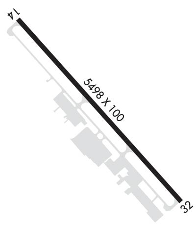
| Lat: N 3908.6 Long: W 07808.7 Elev: 726 Var: +10 Longest Runway: 5498 | ||
| Clr Del: 126.15 AWOS: 124.85 CTAF: 122.7 | ||
| ||||||
| ||||||
|
| Rwy | Rwy | |||||||
| 5498x100 | 5498' | 5498x100 | 5498' | 109.55 - 324° | ||||
| Runway ID | Single Wheel | Double Wheel | Double Tandem Wheel | Dual Double Wheel |
| 14/32 | 75,000 | 150,000 | N/A | N/A |
| These numbers are Advisory and are not limits. The Airport Manager should have more accurate Weight Limits | ||||
 Airport Diagram might not be current. | |
| Facility Name: | WINCHESTER RGNL |
| City Name: | WINCHESTER |
| County: | FREDERICK |
| State abbrev: | VA |
| State Name: | VIRGINIA |
| Ownership: | PUBLICLY OWNED |
| Use: | OPEN TO THE PUBLIC |
| Owner's Name: | WINCHESTER REG ARPT AUTH |
| Address: | 491 AIRPORT RD |
| WINCHESTER, VA 22602 | |
| Owner's Phone: | 540-662-5786 |
| Manager's Name: | NICK SABO |
| Address: | 491 AIRPORT RD |
| WINCHESTER, VA 22602 | |
| Phone: | 540-662-5786 |
| FAA Region: | EASTERN |
| FAA Field Office: | DCA |

| Date | Sunrise | Sunset |
|---|---|---|
| 09/24/21 Friday | 7:02 | 19:07 |
| 09/25/21 Saturday | 7:03 | 19:05 |
| 09/26/21 Sunday | 7:04 | 19:04 |
| 09/27/21 Monday | 7:05 | 19:02 |
| 09/28/21 Tuesday | 7:06 | 19:00 |
| 09/29/21 Wednesday | 7:06 | 18:59 |
| 09/30/21 Thursday | 7:07 | 18:57 |
| 10/01/21 Friday | 7:08 | 18:56 |
| 10/02/21 Saturday | 7:09 | 18:54 |
| 10/03/21 Sunday | 7:10 | 18:52 |
| 10/04/21 Monday | 7:11 | 18:51 |
| 10/05/21 Tuesday | 7:12 | 18:49 |
| 10/06/21 Wednesday | 7:13 | 18:48 |
| 10/07/21 Thursday | 7:14 | 18:46 |
| Airport Attendance Schedule | 7 Days A Week 0600-2200 LCL; AIRPORT ATTENDED 24HRS |
| Airport Status | OPERATIONAL (This Status can change at any time - please check NOTAMS) |
| Airport Lighting Schedule | ACTVT MALSR RY 32; REIL RY 14; HIRL RY14/32 - CTAF. |
| Airport Storage Available | Tie Downs, Hanger |
| Extra Services Available | Air Freight, Avionics, Charter, Flight Instruction, Aircraft Rental |
| Wind Indicator | YES - (lighted) |
| Control Tower | NO |
| CTAF Frequency | 122.700 |
| Unicom Frequency | 122.700 |
| Rotating Beacon Color | CLEAR-GREEN (Light Land Airport) |
| Segmented Circle | YES |
| Landing Fee | NO |
| Airport Inspected | STATE - performed by STATE AERONAUTICAL PERSONNEL |
| Inspection Date | 07/26/2019 |
| Type of Fuel Available | Grade 100LL, JET A (freeze point -40C) |
| Airframe Repair Service | MAJOR |
| Power Plant Repair Service | MAJOR |
| Latitude | N3908.6 |
| Longitude | W07808.7 (ESTIMATED) |
| Arpt Elevation | 726ft (SURVEYED) |
| Magnetic Variation | 10W |
| 3 miles SE | of WINCHESTER |
| Traffic Pattern Altitude | TPA 1980' AGL FOR TURBOPROP AND JET ACFT; ALL OTHER ACFT TPA 980' AGL. |
| Sectional Chart | WASHINGTON |
| Operations (Reported) | Yearly | Avg. Daily |
|---|---|---|
| General Aviation Transient | 22569 | 62 |
| General Aviation Local | 18709 | 51 |
| Air Taxi | 1822 | 5 |
| Commerical | 0 | 0 |
| Commuter | 0 | 0 |
| Military | 0 | 0 |
| Aircraft based on Field | |
|---|---|
| General Aviation Singles | 85 |
| General Aviation Multi | 9 |
| Jet Aircraft | 3 |
| General Aviation Helicopters | 1 |
| Military Aircraft | 0 |
| Gliders | 0 |
| Ultralights | 0 |
| FSS on field | NO |
| FSS tie-in | LEESBURG |
| FSS Phone | 1-800-WX-BRIEF |
| Who issues Notams | OKV |
| Notam D service at airport | YES |
| ARTCC Name | WASHINGTON |
| Airport Certification | |
| Aircraft Rescue & Firefighting Index | None |
| Airport of Entry | No |
| Custom Landing Rights | No |
| Joint Civil/Military | No |
| Military Landing rights | YES |
| NATIONAL PLAN OF INTEGRATED AIRPORT SYSTEMS (NPIAS) |
| GRANT AGREEMENTS UNDER FAAP/ADAP/AIP |
| ASSURANCES PURSUANT TO TITLE VI, CIVIL RIGHTS ACT OF 1964 |
| ADCUS AVBL 24 HRS MIN ADVN NOTICE RQRD CALL 804-661-3660 MON-FRI; AFT HRS AND WKENDS CALL 703-661-3632. |
| DEER ON & INVOF ARPT. |
| MED-FLIGHT: IRREGULAR DEPARTURE PATTERN |
| FOR CD CTC POTOMAC APCH AT 866-709-4993. |
Airport Communications & Frequencies:
| ||||||||||||||||
| Runway: 14 | Runway: 32 | ||
| Mag heading: | 144° | Mag heading: | 324° |
| Rwy Slope: | -.46% Down | Rwy Slope: | .46% Up |
| Approach: | Approach: | ILS/DME | |
| Pattern: | Left Traffic | Pattern: | Left Traffic |
| Markings: | NONPRECISION INSTRUMENT | Markings: | PRECISION INSTRUMENT |
| Marking Condition: | GOOD | Marking Condition: | GOOD |
| Arresting Dev: | Arresting Dev: | ||
| Lat & Long: | N3908.9 W07809.1 | Lat. & Long.: | N3908.3 W07808.2 |
| Elev: | 726.2 ft. MSL | Elev: | 700.8 ft. MSL |
| TCH: | 45 ft. AGL | TCH: | 45 ft. AGL |
| Visual Glide Path: | 3.00 degrees | Visual Glide Path: | 3.00 degrees |
| Displaced Threshold: | No | Displaced Threshold: | No |
| Touchdown Zone: | YES | Touchdown Zone: | YES |
| Touchdown Elev.: | 726.2 feet | Touchdown Elev.: | 714.6 feet |
| Visual Glide Slope: | 4-Light PAPI on LEFT side of Runway | Visual Glide Slope: | 4-Light PAPI on LEFT side of Runway |
| RVR Equipment: | RVR Equipment: | ||
| RVV Equipment: | NO | RVV Equipment: | NO |
| Approach Lights: | Approach Lights: | MALSR - 1,400 foot medium intensity approach lighting system with runway alignment indicator lights | |
| REIL: | YES | REIL: | NO |
| Centerline Lights: | NO | Centerline Lights: | NO |
| Touchdown lights: | NO | Touchdown lights: | NO |
| Runway Category: | D | Runway Category: | Precision Instrument Runway |
| Declared Distances: | Declared Distances: | ||
| Obstructions: | TREE | Obstructions: | TREE |
| Marked: | NOT Marked/Lighted | Marked: | NOT Marked/Lighted |
| Clearance slope: | 28:1 | Clearance slope: | 38:1 |
| Obstruction height: | 71 feet AGL | Obstruction height: | 35 feet AGL |
| Dist. from runway: | 2214 feet | Dist. from runway: | 1555 feet |
| Centerline offset: | 31 left of centerline | Centerline offset: | 317 feet left of centerline |
| Comments: | Comments: |
Thanks for using FltPlan.com
all rights reserved © 1999-2021 by Flight Plan LLC