
| WILL ROGERS WORLD OKLAHOMA CITY OK |
| |
| Lat: N 3523.6 Long: W 09736.0 Elev: 1296 Var: -04 Longest Runway: 9803 | ||
| Clr Del: 124.35 Dept. ATIS: 125.85 Arr. ATIS: 125.85 Ground: 121.9 Tower: 119.35/120.25 | ||
| ||||||||||||||||||||||||||||||||||||||||||||||||||||||||||||||||||||
| ||||||||||||||||||||||||||||||||||||||||||||||||||||||||||||||||||||
| ||||||||||||||||||||||||||||||||||||||||||||||||||||||||||||||||||||
| ||||||||||||||||||||||||||||||||||||||||||||||||||||||||||||||||||||
| ||||||||||||||||||||||||||||||||||||||||||||||||||||||||||||||||||||
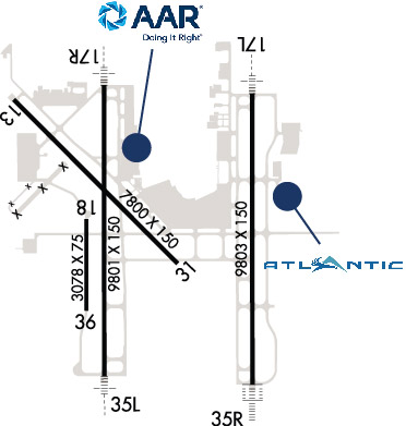
| Rwy | Rwy | |||||||
| 7800x150 | 7800' | 7800x150 | 7800' | |||||
| 9803x150 | 9803' | 110.90 - 175° | 9803x150 | 9803' | 110.90 - 355° | |||
| 9801x150 | 9801' | 110.70 - 175° | 9801x150 | 9801' | 110.70 - 355° | |||
| 3078x75 | 3078' | 3078x75 | 3078' | |||||
| Runway ID | Single Wheel | Double Wheel | Double Tandem Wheel | Dual Double Wheel |
| 13/31 | 120,000 | 250,000 | 489,000 | N/A |
| 17L/35R | 120,000 | 250,000 | 550,000 | N/A |
| 17R/35L | 120,000 | 250,000 | 550,000 | N/A |
| 18/36 | 116,000 | 164,000 | 269,000 | N/A |
| These numbers are Advisory and are not limits. The Airport Manager should have more accurate Weight Limits | ||||
 Airport Diagram might not be current. | |
| Facility Name: | WILL ROGERS WORLD |
| City Name: | OKLAHOMA CITY |
| County: | OKLAHOMA |
| State abbrev: | OK |
| State Name: | OKLAHOMA |
| Ownership: | PUBLICLY OWNED |
| Use: | OPEN TO THE PUBLIC |
| Owner's Name: | OKLAHOMA CITY AIRPORT TRUST |
| Address: | 7100 TERMINAL DR; BOX 937 |
| OKLAHOMA CITY, OK 73159-0937 | |
| Owner's Phone: | 405-316-3200 |
| Manager's Name: | MARK KRANENBURG DIRECTOR |
| Address: | 7100 TERMINAL DR; BOX 937 |
| OKLAHOMA CITY, OK 73159-0937 | |
| Phone: | 405-316-3200 |
| FAA Region: | SOUTHWEST |
| FAA Field Office: | AOK |
| Date | Sunrise | Sunset |
|---|---|---|
| 09/24/21 Friday | 7:20 | 19:25 |
| 09/25/21 Saturday | 7:20 | 19:23 |
| 09/26/21 Sunday | 7:21 | 19:22 |
| 09/27/21 Monday | 7:22 | 19:20 |
| 09/28/21 Tuesday | 7:23 | 19:19 |
| 09/29/21 Wednesday | 7:24 | 19:17 |
| 09/30/21 Thursday | 7:24 | 19:16 |
| 10/01/21 Friday | 7:25 | 19:15 |
| 10/02/21 Saturday | 7:26 | 19:13 |
| 10/03/21 Sunday | 7:27 | 19:12 |
| 10/04/21 Monday | 7:27 | 19:10 |
| 10/05/21 Tuesday | 7:28 | 19:09 |
| 10/06/21 Wednesday | 7:29 | 19:07 |
| 10/07/21 Thursday | 7:30 | 19:06 |
| Airport Attendance Schedule | CONTINUOUS |
| Airport Status | OPERATIONAL (This Status can change at any time - please check NOTAMS) |
| Airport Lighting Schedule | SS-SR |
| Airport Storage Available | Tie Downs, Hanger |
| Extra Services Available | Air Freight, Avionics, Cargo Handling, Charter, Flight Instruction, Aircraft Rental, Aircraft Sales |
| Wind Indicator | YES - (lighted) |
| Control Tower | YES |
| CTAF Frequency | |
| Unicom Frequency | |
| Rotating Beacon Color | CLEAR-GREEN (Light Land Airport) |
| Segmented Circle | NO |
| Landing Fee | NO |
| Airport Inspected | FEDERAL - performed by FAA AIRPORTS FIELD PERSONNEL |
| Inspection Date | 06/09/2021 |
| Type of Fuel Available | Grade 100LL, JET A (freeze point -40C) |
| Airframe Repair Service | MAJOR |
| Power Plant Repair Service | MAJOR |
| Latitude | N3523.6 |
| Longitude | W09736.0 (ESTIMATED) |
| Arpt Elevation | 1295ft (SURVEYED) |
| Magnetic Variation | 04E |
| 6 miles SW | of OKLAHOMA CITY |
| Traffic Pattern Altitude | |
| Sectional Chart | DALLAS-FT WORTH |
| Operations (Reported) | Yearly | Avg. Daily |
|---|---|---|
| General Aviation Transient | 13160 | 36 |
| General Aviation Local | 595 | 2 |
| Air Taxi | 7036 | 19 |
| Commerical | 32115 | 88 |
| Commuter | 0 | 0 |
| Military | 34830 | 95 |
| Aircraft based on Field | |
|---|---|
| General Aviation Singles | 3 |
| General Aviation Multi | 1 |
| Jet Aircraft | 23 |
| General Aviation Helicopters | 9 |
| Military Aircraft | 7 |
| Gliders | 0 |
| Ultralights | 0 |
| FSS on field | NO |
| FSS tie-in | MC ALESTER |
| FSS Phone | 1-800-WX-BRIEF |
| Who issues Notams | OKC |
| Notam D service at airport | YES |
| ARTCC Name | FORT WORTH |
| Airport Certification | AIRPORT RECEIVING SCHEDULED AIR CARRIER SERVICE FROM CARRIERS CERTIFICATED BY THE CIVIL AERONAUTICS BOARD |
| Aircraft Rescue & Firefighting Index | AIRPORT HAS A CERTIFICATE UNDER CFR PART 139 |
| Airport of Entry | No |
| Custom Landing Rights | YES |
| Joint Civil/Military | No |
| Military Landing rights | YES |
| NATIONAL PLAN OF INTEGRATED AIRPORT SYSTEMS (NPIAS) |
| GRANT AGREEMENTS UNDER FAAP/ADAP/AIP |
| SURPLUS PROPERTY AGREEMENT UNDER PUBLIC LAW 289 |
| SURPLUS PROPERTY AGREEMENT UNDER REGULATION 16-WAA |
| ASSURANCES PURSUANT TO TITLE VI, CIVIL RIGHTS ACT OF 1964 |
| RY 18/36 USED AS TWY WHEN NOT USED AS RY. |
| RY 18/36 VFR DALGT OPNS ONLY EXCEPT FOR AIR NATIONAL GUARD. |
| FLIGHT NOTIFICATION SERVICE (ADCUS) AVBL. |
| COMPASS ROSE RSTRD TO ACFT UNDER 95000 LBS EXCP ANG C-130. TWY B NORTH OF COMPASS ROSE RSTRD TO ACFT UNDER 120000 LBS EXCP ANG C-130. |
| PILOTS OF ACFT WITH WING SPANS GREATER THAN 118 FT MUST USE JUDGMENTAL OVER STEERING AT ALL TWY INTXNS. |
| TWYS H2 AND G EAST OF TWY H CLSD INDEFLY. |
| NUMEROUS BIRDS ON & INVOF ARPT. |
| MILITARY: SVC: FUEL A, A+ (C405-787-4043) (NC-100LL). |
| PPR FOR PARKING ON FAA AERONAUTICAL CENTER RAMP PHONE 405-954-9783 AND EMAIL MXC@FAA.GOV. |
| RY 18/36 600 FT WEST OF RY 17R/35L ON EXISTING TWY. |
| RY 18/36; TWY G WEST OF RY 17R/35L; TWY A2 EAST OF TWY A; TWY D SW OF RY 13/31; TWYS A1; A3; A4; A6; B; AND C2 NOT AVBL FOR ACR OPNS WITH OVER 9 PSGR SEATS. |
| TWY G WEST OF TWY B CLSD TO ALL EXCEPT U.S. MARSHALS SERVICE ACFT. |
| TWY C2 CLSD TO ALL OPNS EXCEPT METRO TECH TFC. |
| ALL RAMPS ARE UNCONTROLLED. |
Airport Communications & Frequencies:
| |||||||||||||||||||||||||||||||||||||||||||||||||||||||||||||||||||
| Runway: 13 | Runway: 31 | ||
| Mag heading: | 131° | Mag heading: | 311° |
| Rwy Slope: | .09% Up | Rwy Slope: | -.09% Down |
| Approach: | Approach: | ||
| Pattern: | Right Traffic | Pattern: | Left Traffic |
| Markings: | NONPRECISION INSTRUMENT | Markings: | NONPRECISION INSTRUMENT |
| Marking Condition: | GOOD | Marking Condition: | GOOD |
| Arresting Dev: | Arresting Dev: | ||
| Lat & Long: | N3524.3 W09737.0 | Lat. & Long.: | N3523.4 W09735.8 |
| Elev: | 1278.7 ft. MSL | Elev: | 1286.0 ft. MSL |
| TCH: | 52 ft. AGL | TCH: | 52 ft. AGL |
| Visual Glide Path: | 3.00 degrees | Visual Glide Path: | 3.00 degrees |
| Displaced Threshold: | No | Displaced Threshold: | No |
| Touchdown Zone: | YES | Touchdown Zone: | YES |
| Touchdown Elev.: | 1278.7 feet | Touchdown Elev.: | 1286.1 feet |
| Visual Glide Slope: | 4-Light PAPI on LEFT side of Runway | Visual Glide Slope: | 4-Light PAPI on LEFT side of Runway |
| RVR Equipment: | RVR Equipment: | ||
| RVV Equipment: | NO | RVV Equipment: | NO |
| Approach Lights: | Approach Lights: | ||
| REIL: | YES | REIL: | YES |
| Centerline Lights: | NO | Centerline Lights: | NO |
| Touchdown lights: | NO | Touchdown lights: | NO |
| Runway Category: | Runway with a Non-precision Approach having visibility minimums greater than 3/4 mile | Runway Category: | Runway with a Non-precision Approach having visibility minimums greater than 3/4 mile |
| Declared Distances: | TORA:7800' TODA:7800' ASDA:7800' LDA:7800' | Declared Distances: | TORA:7800' TODA:7800' ASDA:7800' LDA:7800' |
| Runway: 17L | Runway: 35R | ||
| Mag heading: | 176° | Mag heading: | 356° |
| Rwy Slope: | -.04% Down | Rwy Slope: | .04% Up |
| Approach: | ILS/DME | Approach: | ILS/DME |
| Pattern: | Left Traffic | Pattern: | Right Traffic |
| Markings: | PRECISION INSTRUMENT | Markings: | PRECISION INSTRUMENT |
| Marking Condition: | GOOD | Marking Condition: | GOOD |
| Arresting Dev: | Arresting Dev: | ||
| Lat & Long: | N3524.3 W09735.3 | Lat. & Long.: | N3522.7 W09735.3 |
| Elev: | 1286.8 ft. MSL | Elev: | 1283.0 ft. MSL |
| TCH: | TCH: | ||
| Visual Glide Path: | Visual Glide Path: | ||
| Displaced Threshold: | No | Displaced Threshold: | No |
| Touchdown Zone: | YES | Touchdown Zone: | YES |
| Touchdown Elev.: | 1287.0 feet | Touchdown Elev.: | 1294.0 feet |
| Visual Glide Slope: | Visual Glide Slope: | ||
| RVR Equipment: | TOUCHDOWN-MIDFIELD-ROLLOUT | RVR Equipment: | TOUCHDOWN-MIDFIELD-ROLLOUT |
| RVV Equipment: | NO | RVV Equipment: | NO |
| Approach Lights: | MALSR - 1,400 foot medium intensity approach lighting system with runway alignment indicator lights | Approach Lights: | ALSF2 - standard 2,400 foot high intensity approach lighting system with sequenced flashers, Category II or III |
| REIL: | NO | REIL: | NO |
| Centerline Lights: | YES | Centerline Lights: | YES |
| Touchdown lights: | NO | Touchdown lights: | YES |
| Runway Category: | Precision Instrument Runway | Runway Category: | Precision Instrument Runway |
| Declared Distances: | TORA:9802' TODA:9802' ASDA:9802' LDA:9802' | Declared Distances: | TORA:9802' TODA:9802' ASDA:9802' LDA:9802' |
| Runway: 17R | Runway: 35L | ||
| Mag heading: | 176° | Mag heading: | 356° |
| Rwy Slope: | -.19% Down | Rwy Slope: | .19% Up |
| Approach: | ILS/DME | Approach: | ILS/DME |
| Pattern: | Right Traffic | Pattern: | Left Traffic |
| Markings: | PRECISION INSTRUMENT | Markings: | PRECISION INSTRUMENT |
| Marking Condition: | GOOD | Marking Condition: | GOOD |
| Arresting Dev: | Arresting Dev: | ||
| Lat & Long: | N3524.4 W09736.3 | Lat. & Long.: | N3522.7 W09736.3 |
| Elev: | 1281.7 ft. MSL | Elev: | 1263.3 ft. MSL |
| TCH: | 60 ft. AGL | TCH: | |
| Visual Glide Path: | 3.00 degrees | Visual Glide Path: | |
| Displaced Threshold: | No | Displaced Threshold: | No |
| Touchdown Zone: | YES | Touchdown Zone: | YES |
| Touchdown Elev.: | 1282.2 feet | Touchdown Elev.: | 1276.3 feet |
| Visual Glide Slope: | 4-Light PAPI on LEFT side of Runway; PAPI UNUSBL 4 DEGS RIGHT OF RWY CNTRLN. | Visual Glide Slope: | |
| RVR Equipment: | TOUCHDOWN-ROLLOUT | RVR Equipment: | TOUCHDOWN-ROLLOUT |
| RVV Equipment: | NO | RVV Equipment: | NO |
| Approach Lights: | MALSR - 1,400 foot medium intensity approach lighting system with runway alignment indicator lights | Approach Lights: | MALSR - 1,400 foot medium intensity approach lighting system with runway alignment indicator lights |
| REIL: | NO | REIL: | NO |
| Centerline Lights: | YES | Centerline Lights: | YES |
| Touchdown lights: | NO | Touchdown lights: | NO |
| Runway Category: | Precision Instrument Runway | Runway Category: | Precision Instrument Runway |
| Declared Distances: | TORA:9800' TODA:9800' ASDA:9800' LDA:9800' | Declared Distances: | TORA:9800' TODA:9800' ASDA:9800' LDA:9800' |
| Runway: 18 | Runway: 36 | ||
| Mag heading: | 176° | Mag heading: | 356° |
| Rwy Slope: | -.12% Down | Rwy Slope: | .12% Up |
| Approach: | Approach: | ||
| Pattern: | Right Traffic | Pattern: | Left Traffic |
| Markings: | BASIC | Markings: | BASIC |
| Marking Condition: | GOOD | Marking Condition: | GOOD |
| Arresting Dev: | Arresting Dev: | ||
| Lat & Long: | N3523.6 W09736.5 | Lat. & Long.: | N3523.1 W09736.5 |
| Elev: | 1274.9 ft. MSL | Elev: | 1271.3 ft. MSL |
| TCH: | TCH: | ||
| Visual Glide Path: | Visual Glide Path: | ||
| Displaced Threshold: | No | Displaced Threshold: | No |
| Touchdown Zone: | YES | Touchdown Zone: | YES |
| Touchdown Elev.: | 1277.8 feet | Touchdown Elev.: | 1277.8 feet |
| Visual Glide Slope: | Visual Glide Slope: | ||
| RVR Equipment: | RVR Equipment: | ||
| RVV Equipment: | NO | RVV Equipment: | NO |
| Approach Lights: | Approach Lights: | ||
| REIL: | NO | REIL: | NO |
| Centerline Lights: | NO | Centerline Lights: | NO |
| Touchdown lights: | NO | Touchdown lights: | NO |
| Runway Category: | Runway with a Visual Approach | Runway Category: | Runway with a Visual Approach |
| Declared Distances: | TORA:3079' TODA:3079' ASDA:3079' LDA:3079' | Declared Distances: | TORA:3079' TODA:3079' ASDA:3079' LDA:3079' |
Thanks for using FltPlan.com
all rights reserved © 1999-2021 by Flight Plan LLC


