
| THOMAS P STAFFORD WEATHERFORD OK |
| |
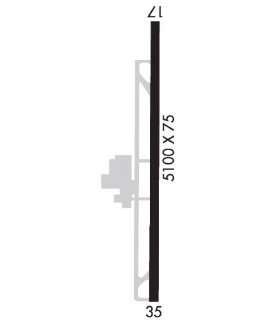
| Lat: N 3532.7 Long: W 09840.1 Elev: 1605 Var: -06 Longest Runway: 5100 | ||
| AWOS: 118.57 CTAF: 122.8 | ||
| ||||||||||||||||||||||||||||||||||||||||||||||||||||||||||||||||||||
| ||||||||||||||||||||||||||||||||||||||||||||||||||||||||||||||||||||
| ||||||||||||||||||||||||||||||||||||||||||||||||||||||||||||||||||||
| Rwy | Rwy | |||||||
| 5100x75 | 5100' | 5100x75 | 5100' | |||||
| Runway ID | Single Wheel | Double Wheel | Double Tandem Wheel | Dual Double Wheel |
| 17/35 | 30,000 | 48,000 | N/A | N/A |
| These numbers are Advisory and are not limits. The Airport Manager should have more accurate Weight Limits | ||||
 Airport Diagram might not be current. | |
| Facility Name: | WEATHERFORD STAFFORD |
| City Name: | WEATHERFORD |
| County: | CUSTER |
| State abbrev: | OK |
| State Name: | OKLAHOMA |
| Ownership: | PUBLICLY OWNED |
| Use: | OPEN TO THE PUBLIC |
| Owner's Name: | CITY OF WEATHERFORD |
| Address: | 522 W. RAINEY, P. O. BOX 569 |
| WEATHERFORD, OK 73096 | |
| Owner's Phone: | 580-772-7451 |
| Manager's Name: | MARK SCHOONMAKER |
| Address: | 3000 LOGAN ROAD |
| WEATHERFORD, OK 73096 | |
| Phone: | 580-774-1971 |
| FAA Region: | SOUTHWEST |
| FAA Field Office: | AOK |
| Date | Sunrise | Sunset |
|---|---|---|
| 06/07/26 Sunday | 6:19 | 20:48 |
| 06/08/26 Monday | 6:19 | 20:49 |
| 06/09/26 Tuesday | 6:19 | 20:49 |
| 06/10/26 Wednesday | 6:19 | 20:50 |
| 06/11/26 Thursday | 6:19 | 20:50 |
| 06/12/26 Friday | 6:19 | 20:50 |
| 06/13/26 Saturday | 6:19 | 20:51 |
| 06/14/26 Sunday | 6:19 | 20:51 |
| 06/15/26 Monday | 6:19 | 20:52 |
| 06/16/26 Tuesday | 6:19 | 20:52 |
| 06/17/26 Wednesday | 6:19 | 20:52 |
| 06/18/26 Thursday | 6:19 | 20:53 |
| 06/19/26 Friday | 6:19 | 20:53 |
| 06/20/26 Saturday | 6:19 | 20:53 |
| Airport Attendance Schedule | MON-FRI 0800-1730, SAT 0800-1700, SUN 1200-1700 |
| Airport Status | OPERATIONAL (This Status can change at any time - please check NOTAMS) |
| Airport Lighting Schedule | REIL RWY 17 & 35; MIRL RWY 17/35 ON SS-SR; INCR INTST - CTAF. PAPI RWY 17 & 35 ON CONSLY. |
| Airport Storage Available | Tie Downs, Hanger |
| Extra Services Available | Avionics, Flight Instruction, Aircraft Rental |
| Wind Indicator | YES - (lighted) |
| Control Tower | NO |
| CTAF Frequency | 122.800 |
| Unicom Frequency | 122.800 |
| Rotating Beacon Color | WG |
| Segmented Circle | NO |
| Landing Fee | NO |
| Airport Inspected | STATE - performed by STATE AERONAUTICAL PERSONNEL |
| Inspection Date | 07/23/2024 |
| Type of Fuel Available | Grade 100LL, JET A |
| Airframe Repair Service | MAJOR |
| Power Plant Repair Service | MAJOR |
| Latitude | N3532.7 |
| Longitude | W09840.1 (ESTIMATED) |
| Arpt Elevation | 1605ft (SURVEYED) |
| Magnetic Variation | 06E |
| 2 miles NE | of WEATHERFORD |
| Traffic Pattern Altitude | |
| Sectional Chart | DALLAS-FT WORTH |
| Operations (Reported) | Yearly | Avg. Daily |
|---|---|---|
| General Aviation Transient | 0 | 0 |
| General Aviation Local | 0 | 0 |
| Air Taxi | 0 | 0 |
| Commerical | 0 | 0 |
| Commuter | 0 | 0 |
| Military | 0 | 0 |
| Aircraft based on Field | |
|---|---|
| General Aviation Singles | 0 |
| General Aviation Multi | 0 |
| Jet Aircraft | 0 |
| General Aviation Helicopters | 0 |
| Military Aircraft | 0 |
| Gliders | 0 |
| Ultralights | 0 |
| FSS on field | NO |
| FSS tie-in | MC ALESTER |
| FSS Phone | 1-800-WX-BRIEF |
| Who issues Notams | MLC |
| Notam D service at airport | YES |
| ARTCC Name | FORT WORTH |
| Airport Certification | |
| Aircraft Rescue & Firefighting Index | None |
| Airport of Entry | No |
| Custom Landing Rights | No |
| Joint Civil/Military | No |
| Military Landing rights | YES |
| NATIONAL PLAN OF INTEGRATED AIRPORT SYSTEMS (NPIAS) |
| GRANT AGREEMENTS UNDER FAAP/ADAP/AIP |
| ASSURANCES PURSUANT TO TITLE VI, CIVIL RIGHTS ACT OF 1964 |
| FOR CD CTC FORT WORTH ARTCC AT 817-858-7584. |
| FBO CLSD SOME HOLS. |
Airport Communications & Frequencies:
| |||||||||
| Runway: 17 | Runway: 35 | ||
| Mag heading: | 174° | Mag heading: | 354° |
| Rwy Slope: | -.02% Down | Rwy Slope: | .02% Up |
| Approach: | Approach: | ||
| Pattern: | Left Traffic | Pattern: | Left Traffic |
| Markings: | NONPRECISION INSTRUMENT | Markings: | NONPRECISION INSTRUMENT |
| Marking Condition: | GOOD | Marking Condition: | GOOD |
| Arresting Dev: | Arresting Dev: | ||
| Lat & Long: | N3533.2 W09840.1 | Lat. & Long.: | N3532.3 W09840.1 |
| Elev: | 1599.6 ft. MSL | Elev: | 1598.8 ft. MSL |
| TCH: | 57 ft. AGL | TCH: | 41 ft. AGL |
| Visual Glide Path: | 3.34 degrees | Visual Glide Path: | 2.92 degrees |
| Displaced Threshold: | No | Displaced Threshold: | No |
| Touchdown Zone: | YES | Touchdown Zone: | YES |
| Touchdown Elev.: | 1605.3 feet | Touchdown Elev.: | 1605.3 feet |
| Visual Glide Slope: | 2-Light PAPI on LEFT side of Runway | Visual Glide Slope: | 2-Light PAPI on LEFT side of Runway |
| RVR Equipment: | RVR Equipment: | ||
| RVV Equipment: | NO | RVV Equipment: | NO |
| Approach Lights: | Approach Lights: | ||
| REIL: | YES | REIL: | YES |
| Centerline Lights: | NO | Centerline Lights: | NO |
| Touchdown lights: | NO | Touchdown lights: | NO |
| Runway Category: | Runway with a Non-precision Approach having visibility minimums greater than 3/4 mile | Runway Category: | Runway with a Non-precision Approach having visibility minimums greater than 3/4 mile |
| Declared Distances: | Declared Distances: | ||
| Obstructions: | TREES; INSTA HWY 844 FT FM RWY 35 END BOTH SIDES CREATES 21:1 OBS-CLNC SLP. | Obstructions: | PLINE |
| Marked: | NOT Marked/Lighted | Marked: | MARKED and LIGHTED |
| Clearance slope: | 15:1 | Clearance slope: | 18:1 |
| Obstruction height: | 42 feet AGL | Obstruction height: | 49 feet AGL |
| Dist. from runway: | 851 feet | Dist. from runway: | 1090 feet |
| Centerline offset: | 165 right of centerline | Centerline offset: | |
| Comments: | Comments: |
Thanks for using FltPlan.com
all rights reserved © 1999-2026 by Flight Plan LLC


