| OGDEN-HINCKLEY OGDEN UT |
| |
| Lat: N 4111.7 Long: W 11200.7 Elev: 4473 Var: -11 Longest Runway: 8107 | ||
| Dept. ATIS: 125.55 Arr. ATIS: 125.55 AWOS: 125.55 Ground: 121.7 Tower: 118.7 | ||
| ||||||||||||||||||||||||||||||||||||||||||||||||||||||||||||||||||||
| ||||||||||||||||||||||||||||||||||||||||||||||||||||||||||||||||||||
| ||||||||||||||||||||||||||||||||||||||||||||||||||||||||||||||||||||
| ||||||||||||||||||||||||||||||||||||||||||||||||||||||||||||||||||||
| Rwy | Rwy | |||||||
| 8107x150 | 8107' | 111.70 - 033° | 8107x150 | 7253' | ||||
| 5195x100 | 5195' | 5195x100 | 5195' | |||||
| Runway ID | Single Wheel | Double Wheel | Double Tandem Wheel | Dual Double Wheel |
| 03/21 | 120,000 | 203,000 | 344,000 | N/A |
| 17/35 | 80,000 | 140,000 | N/A | N/A |
| These numbers are Advisory and are not limits. The Airport Manager should have more accurate Weight Limits | ||||
 Airport Diagram might not be current. | |
| Facility Name: | OGDEN-HINCKLEY |
| City Name: | OGDEN |
| County: | WEBER |
| State abbrev: | UT |
| State Name: | UTAH |
| Ownership: | PUBLICLY OWNED |
| Use: | OPEN TO THE PUBLIC |
| Owner's Name: | OGDEN CITY CORPORATION |
| Address: | 2549 WASHINGTON BLVD |
| OGDEN, UT 84401 | |
| Owner's Phone: | 801-629-8223 |
| Manager's Name: | BRIAN CONDIE |
| Address: | 3909 AIRPORT ROAD |
| OGDEN, UT 84405 | |
| Phone: | 801-629-8223 |
| FAA Region: | NORTHWEST MOUNTAIN |
| FAA Field Office: | DEN |
| Date | Sunrise | Sunset |
|---|---|---|
| 06/08/26 Monday | 5:55 | 20:59 |
| 06/09/26 Tuesday | 5:55 | 21:00 |
| 06/10/26 Wednesday | 5:55 | 21:00 |
| 06/11/26 Thursday | 5:55 | 21:01 |
| 06/12/26 Friday | 5:55 | 21:01 |
| 06/13/26 Saturday | 5:55 | 21:02 |
| 06/14/26 Sunday | 5:55 | 21:02 |
| 06/15/26 Monday | 5:55 | 21:03 |
| 06/16/26 Tuesday | 5:55 | 21:03 |
| 06/17/26 Wednesday | 5:55 | 21:03 |
| 06/18/26 Thursday | 5:55 | 21:04 |
| 06/19/26 Friday | 5:55 | 21:04 |
| 06/20/26 Saturday | 5:55 | 21:04 |
| 06/21/26 Sunday | 5:55 | 21:04 |
| Airport Attendance Schedule | CONTINUOUS |
| Airport Status | OPERATIONAL (This Status can change at any time - please check NOTAMS) |
| Airport Lighting Schedule | WHEN ATCT CLSD ACTVT MALS RWY 03; REIL RWY 17 & 35; PAPI RWY 03 & 21, 17 & 35; HIRL RWY 03/21; MIRL RWY 17/35; TWY LGTS - CTAF. |
| Airport Storage Available | Tie Downs, Hanger |
| Extra Services Available | Crop Dusting, Avionics, Charter, Flight Instruction, Parachute Jumping, Aircraft Rental, Aircraft Sales, Annual Surveying |
| Wind Indicator | YES - (lighted) |
| Control Tower | YES |
| CTAF Frequency | 118.700 |
| Unicom Frequency | 122.950 |
| Rotating Beacon Color | WG |
| Segmented Circle | YES |
| Landing Fee | YES; GTR THAN 12500 LB. |
| Airport Inspected | FEDERAL - performed by FAA AIRPORTS FIELD PERSONNEL |
| Inspection Date | 02/27/2026 |
| Type of Fuel Available | Grade 100, Grade 100LL, JET A-1 (icing inhibitor, freeze point -50C)J; -J JP4 |
| Airframe Repair Service | MAJOR |
| Power Plant Repair Service | MAJOR |
| Latitude | N4111.7 |
| Longitude | W11200.7 (ESTIMATED) |
| Arpt Elevation | 4472ft (SURVEYED) |
| Magnetic Variation | 11E |
| 3 miles SW | of OGDEN |
| Traffic Pattern Altitude | TPA 5200 MSL REQD DUE TO INTERFACING TFC FM HILL AFB. |
| Sectional Chart | SALT LAKE CITY |
| Operations (Reported) | Yearly | Avg. Daily |
|---|---|---|
| General Aviation Transient | 0 | 0 |
| General Aviation Local | 0 | 0 |
| Air Taxi | 0 | 0 |
| Commerical | 0 | 0 |
| Commuter | 0 | 0 |
| Military | 0 | 0 |
| Aircraft based on Field | |
|---|---|
| General Aviation Singles | 0 |
| General Aviation Multi | 0 |
| Jet Aircraft | 0 |
| General Aviation Helicopters | 0 |
| Military Aircraft | 0 |
| Gliders | 0 |
| Ultralights | 0 |
| FSS on field | NO |
| FSS tie-in | CEDAR CITY |
| FSS Phone | 1-800-WX-BRIEF |
| Who issues Notams | OGD |
| Notam D service at airport | YES |
| ARTCC Name | SALT LAKE CITY |
| Airport Certification | AIRPORT RECEIVING SCHEDULED AIR CARRIER SERVICE FROM CARRIERS CERTIFICATED BY THE CIVIL AERONAUTICS BOARD; CLSD TO ACFT OPNS WITH MORE THAN 30 PSGR SEATS EXCP PPR, MINIMUM 60 MIN NOTICE RQRD, CALL AMGR 801-629-8223. |
| Aircraft Rescue & Firefighting Index | AIRPORT HAS A CERTIFICATE UNDER CFR PART 139 |
| Airport of Entry | No |
| Custom Landing Rights | No |
| Joint Civil/Military | No |
| Military Landing rights | YES |
| NATIONAL PLAN OF INTEGRATED AIRPORT SYSTEMS (NPIAS) |
| GRANT AGREEMENTS UNDER FAAP/ADAP/AIP |
| ASSURANCES PURSUANT TO TITLE VI, CIVIL RIGHTS ACT OF 1964 |
| AGREEMENT UNDER DLAND OR DCLA HAS EXPIRED. |
| SFC COND UNMON MON-FRI 1700-0800, SAT/SUN UNMON EXC AIR ACR OPS. |
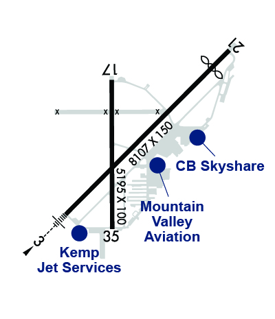
| RWY 3/21, A, B, C, D, E, TRML, AVFLIGHT & SKYSHARE RAMPS AVBL TO ACR. |
| ARPT OPS MNTS 118.7 WHEN TWR CLSD. |
| MULT & PRAC APCH NA. FSL 2200-0700. |
| PAJA NE PTN OF ARPT E OF TWY A. |
| MIL OPS 5700-6300 FT MSL OVR ARPT ENRT TO HILL AFB. |
| FOR CD WHEN ATCT IS CLSD CTC SLC APCH AT 801-325-9670. |
| RWY 03/2 1 ST 152 |
| RWY 03/2 1 PCR VALUE: 500/F/B/X/T |
Airport Communications & Frequencies:
| |||||||||||||||||||||||
| Runway: 03 | Runway: 21 | ||
| Mag heading: | 33° | Mag heading: | 213° |
| Rwy Slope: | -.78% Down | Rwy Slope: | .78% Up |
| Approach: | ILS/DME | Approach: | |
| Pattern: | Left Traffic | Pattern: | Right Traffic |
| Markings: | PRECISION INSTRUMENT | Markings: | NONPRECISION INSTRUMENT |
| Marking Condition: | GOOD | Marking Condition: | GOOD |
| Arresting Dev: | Arresting Dev: | ||
| Lat & Long: | N4111.3 W11201.2 | Lat. & Long.: | N4112.2 W11200.0 |
| Elev: | 4472.5 ft. MSL | Elev: | 4409.0 ft. MSL |
| TCH: | 56 ft. AGL | TCH: | 50 ft. AGL |
| Visual Glide Path: | 3.00 degrees | Visual Glide Path: | 3.00 degrees |
| Displaced Threshold: | No | Displaced Threshold: | 854 feet |
| Touchdown Zone: | YES | Touchdown Zone: | YES |
| Touchdown Elev.: | 4472.5 feet | Touchdown Elev.: | 4438.3 feet |
| Visual Glide Slope: | 4-Light PAPI on LEFT side of Runway | Visual Glide Slope: | 4-Light PAPI on LEFT side of Runway |
| RVR Equipment: | RVR Equipment: | ||
| RVV Equipment: | NO | RVV Equipment: | NO |
| Approach Lights: | MALS - 1,400 foot medium intensity approach lighting system | Approach Lights: | |
| REIL: | NO | REIL: | NO |
| Centerline Lights: | NO | Centerline Lights: | NO |
| Touchdown lights: | NO | Touchdown lights: | NO |
| Runway Category: | Precision Instrument Runway | Runway Category: | Runway with a Visual Approach |
| Declared Distances: | TORA:8107' TODA:8107' ASDA:7253' LDA:7253' | Declared Distances: | TORA:8107' TODA:8107' ASDA:8107' LDA:7253' |
| Obstructions: | TREES | Obstructions: | POLE |
| Marked: | NOT Marked/Lighted | Marked: | NOT Marked/Lighted |
| Clearance slope: | 44:1 | Clearance slope: | 34:1; APCH SLOPE 77:1 TO DTHR. |
| Obstruction height: | 54 feet AGL | Obstruction height: | 24 feet AGL |
| Dist. from runway: | 2425 feet | Dist. from runway: | 1017 feet |
| Centerline offset: | 305 left of centerline | Centerline offset: | 161 feet left of centerline |
| Comments: | Comments: | 17 FT ROAD 350 FT FM THR. |
| Runway: 17 | Runway: 35 | ||
| Mag heading: | 168° | Mag heading: | 348° |
| Rwy Slope: | .40% Up | Rwy Slope: | -.40% Down |
| Approach: | Approach: | ||
| Pattern: | Right Traffic | Pattern: | Left Traffic |
| Markings: | BASIC | Markings: | BASIC |
| Marking Condition: | GOOD | Marking Condition: | GOOD |
| Arresting Dev: | Arresting Dev: | ||
| Lat & Long: | N4112.1 W11200.9 | Lat. & Long.: | N4111.2 W11200.9 |
| Elev: | 4436.4 ft. MSL | Elev: | 4457.4 ft. MSL |
| TCH: | 50 ft. AGL | TCH: | 50 ft. AGL |
| Visual Glide Path: | 3.00 degrees | Visual Glide Path: | 3.00 degrees |
| Displaced Threshold: | No | Displaced Threshold: | No |
| Touchdown Zone: | YES | Touchdown Zone: | YES |
| Touchdown Elev.: | 4450.4 feet | Touchdown Elev.: | 4457.5 feet |
| Visual Glide Slope: | 4-Light PAPI on LEFT side of Runway | Visual Glide Slope: | 4-Light PAPI on LEFT side of Runway |
| RVR Equipment: | RVR Equipment: | ||
| RVV Equipment: | NO | RVV Equipment: | NO |
| Approach Lights: | Approach Lights: | ||
| REIL: | YES | REIL: | YES |
| Centerline Lights: | NO | Centerline Lights: | NO |
| Touchdown lights: | NO | Touchdown lights: | NO |
| Runway Category: | Runway with a Visual Approach | Runway Category: | Runway with a Visual Approach |
| Declared Distances: | TORA:5195' TODA:5195' ASDA:5195' LDA:5195' | Declared Distances: | TORA:5195' TODA:5195' ASDA:5195' LDA:5195' |
| Obstructions: | ROAD | Obstructions: | SIGN |
| Marked: | NOT Marked/Lighted | Marked: | NOT Marked/Lighted |
| Clearance slope: | 3:1 | Clearance slope: | 20:1 |
| Obstruction height: | 3 feet AGL | Obstruction height: | 50 feet AGL |
| Dist. from runway: | 210 feet | Dist. from runway: | 1200 feet |
| Centerline offset: | 125 right of centerline | Centerline offset: | 200 feet right of centerline |
| Comments: | Comments: |
Thanks for using FltPlan.com
all rights reserved © 1999-2026 by Flight Plan LLC