
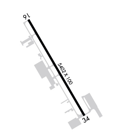
| HANOVER COUNTY MUNI RICHMOND/ASHLAND VA |
| |
| Lat: N 3742.5 Long: W 07726.2 Elev: 207 Var: +09 Longest Runway: 5402 | ||
| Clr Del: 125.4 AWOS: 119.02 CTAF: 122.7 | ||
| ||||||||||||||||||||||||||||||||||||||||||||
| ||||||||||||||||||||||||||||||||||||||||||||
| ||||||||||||||||||||||||||||||||||||||||||||
| Rwy | Rwy | |||||||
| 5402x100 | 5402' | 109.70 - 158° | 5402x100 | 5402' | ||||
| Runway ID | Single Wheel | Double Wheel | Double Tandem Wheel | Dual Double Wheel |
| 16/34 | 40,000 | N/A | N/A | N/A |
| These numbers are Advisory and are not limits. The Airport Manager should have more accurate Weight Limits | ||||
 Airport Diagram might not be current. | |
| Facility Name: | HANOVER COUNTY MUNI |
| City Name: | RICHMOND/ASHLAND |
| County: | HANOVER |
| State abbrev: | VA |
| State Name: | VIRGINIA |
| Ownership: | PUBLICLY OWNED |
| Use: | OPEN TO THE PUBLIC |
| Owner's Name: | COUNTY OF HANOVER |
| Address: | DIRECTOR OF PUBLIC WORKS |
| HANOVER, VA 23069 | |
| Owner's Phone: | 804-365-6179 |
| Manager's Name: | RICHARD HENRY (HANK) REMPE |
| Address: | DEPARTMENT OF PUBLIC WORKS, PO BOX 470 |
| HANOVER, VA 23069 | |
| Phone: | 804-365-6208 |
| FAA Region: | EASTERN |
| FAA Field Office: | DCA |
| Date | Sunrise | Sunset |
|---|---|---|
| 09/24/21 Friday | 6:59 | 19:04 |
| 09/25/21 Saturday | 7:00 | 19:02 |
| 09/26/21 Sunday | 7:01 | 19:01 |
| 09/27/21 Monday | 7:02 | 18:59 |
| 09/28/21 Tuesday | 7:02 | 18:58 |
| 09/29/21 Wednesday | 7:03 | 18:56 |
| 09/30/21 Thursday | 7:04 | 18:55 |
| 10/01/21 Friday | 7:05 | 18:53 |
| 10/02/21 Saturday | 7:06 | 18:52 |
| 10/03/21 Sunday | 7:07 | 18:50 |
| 10/04/21 Monday | 7:08 | 18:49 |
| 10/05/21 Tuesday | 7:09 | 18:47 |
| 10/06/21 Wednesday | 7:10 | 18:46 |
| 10/07/21 Thursday | 7:10 | 18:44 |
| Airport Attendance Schedule | JAN - DEC 7 Days A Week 0700-1900 |
| Airport Status | OPERATIONAL (This Status can change at any time - please check NOTAMS) |
| Airport Lighting Schedule | ACTVT REIL RYS 16 & 34; MIRL RY 16/34 - CTAF. |
| Airport Storage Available | Tie Downs, Hanger |
| Extra Services Available | Air Freight, Crop Dusting, Air Ambulance, Cargo Handling, Charter, Glider, Flight Instruction, Aircraft Rental, Aircraft Sales, Annual Surveying, Glider Towing |
| Wind Indicator | YES - (lighted) |
| Control Tower | NO |
| CTAF Frequency | 122.700 |
| Unicom Frequency | 122.700 |
| Rotating Beacon Color | CLEAR-GREEN (Light Land Airport) |
| Segmented Circle | YES |
| Landing Fee | NO |
| Airport Inspected | STATE - performed by STATE AERONAUTICAL PERSONNEL |
| Inspection Date | 05/08/2019 |
| Type of Fuel Available | Grade 100LL, JET A (freeze point -40C) |
| Airframe Repair Service | MAJOR |
| Power Plant Repair Service | MAJOR |
| Latitude | N3742.5 |
| Longitude | W07726.2 (ESTIMATED) |
| Arpt Elevation | 206ft (SURVEYED) |
| Magnetic Variation | 09W |
| 8 miles N | of RICHMOND/ASHLAND |
| Traffic Pattern Altitude | 800 |
| Sectional Chart | WASHINGTON |
| Operations (Reported) | Yearly | Avg. Daily |
|---|---|---|
| General Aviation Transient | 9465 | 26 |
| General Aviation Local | 25581 | 70 |
| Air Taxi | 1119 | 3 |
| Commerical | 0 | 0 |
| Commuter | 0 | 0 |
| Military | 0 | 0 |
| Aircraft based on Field | |
|---|---|
| General Aviation Singles | 93 |
| General Aviation Multi | 5 |
| Jet Aircraft | 2 |
| General Aviation Helicopters | 2 |
| Military Aircraft | 0 |
| Gliders | 0 |
| Ultralights | 0 |
| FSS on field | NO |
| FSS tie-in | LEESBURG |
| FSS Phone | 1-800-WX-BRIEF |
| Who issues Notams | OFP |
| Notam D service at airport | YES |
| ARTCC Name | WASHINGTON |
| Airport Certification | |
| Aircraft Rescue & Firefighting Index | None |
| Airport of Entry | No |
| Custom Landing Rights | No |
| Joint Civil/Military | No |
| Military Landing rights | No |
| NATIONAL PLAN OF INTEGRATED AIRPORT SYSTEMS (NPIAS) |
| GRANT AGREEMENTS UNDER FAAP/ADAP/AIP |
| ASSURANCES PURSUANT TO TITLE VI, CIVIL RIGHTS ACT OF 1964 |
| THIS AIRPORT HAS BEEN SURVEYED BY THE NATIONAL GEODETIC SURVEY. |
| NOISE SENSITIVE AREA SOUTH OF ARPT. |
| FOR ARPT SERVICES CALL 804-798-6500. |
| DEER & BIRDS ON & INVOF ARPT. |
| FOR CD CTC POTOMAC APCH AT 866-640-4124. |
| RWY 34 PREF RWY WITH WIND LESS THAN 5 KT. |
Airport Communications & Frequencies:
| |||||||||||||||||||||||||||
| Runway: 16 | Runway: 34 | ||
| Mag heading: | 159° | Mag heading: | 339° |
| Rwy Slope: | -.10% Down | Rwy Slope: | .10% Up |
| Approach: | LOC/DME | Approach: | |
| Pattern: | Left Traffic | Pattern: | Left Traffic |
| Markings: | NONPRECISION INSTRUMENT | Markings: | NONPRECISION INSTRUMENT |
| Marking Condition: | FAIR | Marking Condition: | FAIR |
| Arresting Dev: | Arresting Dev: | ||
| Lat & Long: | N3742.9 W07726.5 | Lat. & Long.: | N3742.2 W07725.9 |
| Elev: | 206.5 ft. MSL | Elev: | 201.2 ft. MSL |
| TCH: | 40 ft. AGL | TCH: | |
| Visual Glide Path: | 3.00 degrees | Visual Glide Path: | |
| Displaced Threshold: | No | Displaced Threshold: | No |
| Touchdown Zone: | YES | Touchdown Zone: | YES |
| Touchdown Elev.: | 206.5 feet | Touchdown Elev.: | 204.3 feet |
| Visual Glide Slope: | 4-Light PAPI on LEFT side of Runway | Visual Glide Slope: | |
| RVR Equipment: | RVR Equipment: | ||
| RVV Equipment: | NO | RVV Equipment: | NO |
| Approach Lights: | Approach Lights: | ||
| REIL: | YES | REIL: | YES |
| Centerline Lights: | NO | Centerline Lights: | NO |
| Touchdown lights: | NO | Touchdown lights: | NO |
| Runway Category: | Runway with a Non-precision Approach having visibility minimums greater than 3/4 mile | Runway Category: | Runway with a Non-precision Approach having visibility minimums greater than 3/4 mile |
| Declared Distances: | Declared Distances: | ||
| Obstructions: | TREE | Obstructions: | TREES |
| Marked: | NOT Marked/Lighted | Marked: | NOT Marked/Lighted |
| Clearance slope: | 25:1 | Clearance slope: | 32:1 |
| Obstruction height: | 108 feet AGL | Obstruction height: | 95 feet AGL |
| Dist. from runway: | 2901 feet | Dist. from runway: | 3328 feet |
| Centerline offset: | 42 left of centerline | Centerline offset: | 273 feet right of centerline |
| Comments: | Comments: |
Thanks for using FltPlan.com
all rights reserved © 1999-2021 by Flight Plan LLC
