
| BRANCH COUNTY MEMORIAL COLDWATER MI |
| |
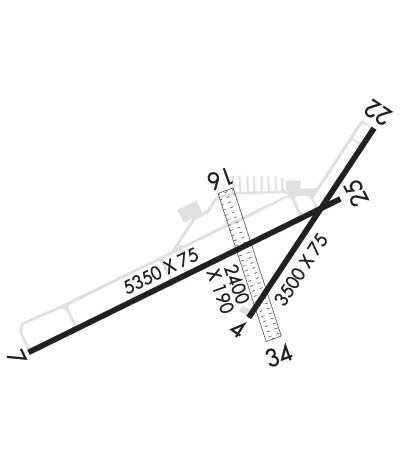
| Lat: N 4156.0 Long: W 08503.1 Elev: 958 Var: +05 Longest Runway: 5350 | ||
| AWOS: 118.12 CTAF: 122.7 | ||
| ||||||||||||||||||||||||||||||||||||||||||||
| ||||||||||||||||||||||||||||||||||||||||||||
| ||||||||||||||||||||||||||||||||||||||||||||
| Rwy | Rwy | |||||||
| 3500x75 | 3500' | 3500x75 | 3500' | |||||
| 5350x75 | 5350' | 5350x75 | 5350' | |||||
| 2399x190 | 1805' | 2399x190 | 2205' | |||||
| Runway ID | Single Wheel | Double Wheel | Double Tandem Wheel | Dual Double Wheel |
| 04/22 | 18,000 | N/A | N/A | N/A |
| 07/25 | 20,000 | N/A | N/A | N/A |
| 16/34 | N/A | N/A | N/A | N/A |
| These numbers are Advisory and are not limits. The Airport Manager should have more accurate Weight Limits | ||||
 Airport Diagram might not be current. | |
| Facility Name: | BRANCH COUNTY MEML |
| City Name: | COLDWATER |
| County: | BRANCH |
| State abbrev: | MI |
| State Name: | MICHIGAN |
| Ownership: | PUBLICLY OWNED |
| Use: | OPEN TO THE PUBLIC |
| Owner's Name: | BRANCH COUNTY |
| Address: | 31 DIVISION ST |
| COLDWATER, MI 49036-1904 | |
| Owner's Phone: | 517-278-2325 |
| Manager's Name: | JOSEPH J BEST |
| Address: | 351 AIRPORT DR |
| COLDWATER, MI 49036-9313 | |
| Phone: | 269-419-9904 |
| FAA Region: | GREAT LAKES |
| FAA Field Office: | DET |
| Date | Sunrise | Sunset |
|---|---|---|
| 09/24/21 Friday | 7:29 | 19:34 |
| 09/25/21 Saturday | 7:30 | 19:33 |
| 09/26/21 Sunday | 7:32 | 19:31 |
| 09/27/21 Monday | 7:33 | 19:29 |
| 09/28/21 Tuesday | 7:34 | 19:27 |
| 09/29/21 Wednesday | 7:35 | 19:26 |
| 09/30/21 Thursday | 7:36 | 19:24 |
| 10/01/21 Friday | 7:37 | 19:22 |
| 10/02/21 Saturday | 7:38 | 19:21 |
| 10/03/21 Sunday | 7:39 | 19:19 |
| 10/04/21 Monday | 7:40 | 19:17 |
| 10/05/21 Tuesday | 7:41 | 19:15 |
| 10/06/21 Wednesday | 7:42 | 19:14 |
| 10/07/21 Thursday | 7:43 | 19:12 |
| Airport Attendance Schedule | MON-FRI 0900-1700; FOR ATTENDANT AFT HRS & WKENDS CALL 517-677-1888. |
| Airport Status | OPERATIONAL (This Status can change at any time - please check NOTAMS) |
| Airport Lighting Schedule | ACTVT REIL RWY 07 & 25; PAPI RWY 07 & 25; MIRL RWY 07/25 & 04/22 - CTAF. |
| Airport Storage Available | Tie Downs, Hanger |
| Extra Services Available | Flight Instruction, Aircraft Rental, Aircraft Sales |
| Wind Indicator | YES - (lighted) |
| Control Tower | NO |
| CTAF Frequency | 122.700 |
| Unicom Frequency | 122.700 |
| Rotating Beacon Color | CLEAR-GREEN (Light Land Airport) |
| Segmented Circle | YES |
| Landing Fee | NO |
| Airport Inspected | STATE - performed by STATE AERONAUTICAL PERSONNEL |
| Inspection Date | 03/10/2021 |
| Type of Fuel Available | Grade 100LL, JET A; -10FUEL AVBL H24 SELF SER. |
| Airframe Repair Service | MAJOR |
| Power Plant Repair Service | MAJOR |
| Latitude | N4156.0 |
| Longitude | W08503.1 (ESTIMATED) |
| Arpt Elevation | 958ft (SURVEYED) |
| Magnetic Variation | 05W |
| 3 miles W | of COLDWATER |
| Traffic Pattern Altitude | |
| Sectional Chart | CHICAGO |
| Operations (Reported) | Yearly | Avg. Daily |
|---|---|---|
| General Aviation Transient | 7000 | 19 |
| General Aviation Local | 5000 | 14 |
| Air Taxi | 0 | 0 |
| Commerical | 0 | 0 |
| Commuter | 0 | 0 |
| Military | 0 | 0 |
| Aircraft based on Field | |
|---|---|
| General Aviation Singles | 28 |
| General Aviation Multi | 2 |
| Jet Aircraft | 1 |
| General Aviation Helicopters | 1 |
| Military Aircraft | 0 |
| Gliders | 0 |
| Ultralights | 0 |
| FSS on field | NO |
| FSS tie-in | LANSING |
| FSS Phone | 1-800-WX-BRIEF |
| Who issues Notams | OEB |
| Notam D service at airport | YES |
| ARTCC Name | CHICAGO |
| Airport Certification | |
| Aircraft Rescue & Firefighting Index | None |
| Airport of Entry | No |
| Custom Landing Rights | No |
| Joint Civil/Military | No |
| Military Landing rights | YES |
| NATIONAL PLAN OF INTEGRATED AIRPORT SYSTEMS (NPIAS) |
| GRANT AGREEMENTS UNDER FAAP/ADAP/AIP |
| ASSURANCES PURSUANT TO TITLE VI, CIVIL RIGHTS ACT OF 1964 |
| RWY 16/34 NOT PLOWED, CLSD NOV-MAR. |
| BIRDS & DEER ON & INVOF ARPT. |
| ADMIN BLDG ACES: 5-3-2-1 OR CTAF. |
| FOR CD CTC GREAT LAKES APCH AT 269-459-3344, WHEN APCH CLSD CTC CHICAGO ARTCC AT 630-906-8921. |
| RWY 25 CALM WIND RWY. |
Airport Communications & Frequencies:
| |||||||||||||||||
| Runway: 04 | Runway: 22 | ||
| Mag heading: | 39° | Mag heading: | 219° |
| Rwy Slope: | -.01% Down | Rwy Slope: | .01% Up |
| Approach: | Approach: | ||
| Pattern: | Left Traffic | Pattern: | Left Traffic |
| Markings: | BASIC | Markings: | BASIC |
| Marking Condition: | GOOD | Marking Condition: | GOOD |
| Arresting Dev: | Arresting Dev: | ||
| Lat & Long: | N4155.9 W08503.1 | Lat. & Long.: | N4156.3 W08502.7 |
| Elev: | 955.3 ft. MSL | Elev: | 954.9 ft. MSL |
| TCH: | TCH: | ||
| Visual Glide Path: | Visual Glide Path: | ||
| Displaced Threshold: | No | Displaced Threshold: | No |
| Touchdown Zone: | YES | Touchdown Zone: | YES |
| Touchdown Elev.: | 955.5 feet | Touchdown Elev.: | 954.9 feet |
| Visual Glide Slope: | Visual Glide Slope: | ||
| RVR Equipment: | RVR Equipment: | ||
| RVV Equipment: | NO | RVV Equipment: | NO |
| Approach Lights: | Approach Lights: | ||
| REIL: | NO | REIL: | NO |
| Centerline Lights: | NO | Centerline Lights: | NO |
| Touchdown lights: | NO | Touchdown lights: | NO |
| Runway Category: | Runway with a Visual Approach | Runway Category: | Runway with a Visual Approach |
| Declared Distances: | Declared Distances: |
| Runway: 07 | Runway: 25 | ||
| Mag heading: | 69° | Mag heading: | 249° |
| Rwy Slope: | -.05% Down | Rwy Slope: | .05% Up |
| Approach: | Approach: | ||
| Pattern: | Left Traffic | Pattern: | Left Traffic |
| Markings: | NONPRECISION INSTRUMENT | Markings: | NONPRECISION INSTRUMENT |
| Marking Condition: | GOOD | Marking Condition: | GOOD |
| Arresting Dev: | Arresting Dev: | ||
| Lat & Long: | N4155.8 W08503.8 | Lat. & Long.: | N4156.2 W08502.8 |
| Elev: | 956.1 ft. MSL | Elev: | 953.3 ft. MSL |
| TCH: | 32 ft. AGL | TCH: | 40 ft. AGL |
| Visual Glide Path: | 3.00 degrees | Visual Glide Path: | 3.00 degrees |
| Displaced Threshold: | No | Displaced Threshold: | No |
| Touchdown Zone: | YES | Touchdown Zone: | YES |
| Touchdown Elev.: | 958.3 feet | Touchdown Elev.: | 958.3 feet |
| Visual Glide Slope: | 2-Light PAPI on LEFT side of Runway | Visual Glide Slope: | 2-Light PAPI on LEFT side of Runway |
| RVR Equipment: | RVR Equipment: | ||
| RVV Equipment: | NO | RVV Equipment: | NO |
| Approach Lights: | Approach Lights: | ||
| REIL: | YES | REIL: | YES |
| Centerline Lights: | NO | Centerline Lights: | NO |
| Touchdown lights: | NO | Touchdown lights: | NO |
| Runway Category: | Runway with a Non-precision Approach having visibility minimums greater than 3/4 mile | Runway Category: | Runway with a Non-precision Approach having visibility minimums greater than 3/4 mile |
| Declared Distances: | Declared Distances: | ||
| Obstructions: | TREE | Obstructions: | POLE |
| Marked: | NOT Marked/Lighted | Marked: | LIGHTED |
| Clearance slope: | 21:1 | Clearance slope: | 9:1 |
| Obstruction height: | 37 feet AGL | Obstruction height: | 15 feet AGL |
| Dist. from runway: | 1003 feet | Dist. from runway: | 340 feet |
| Centerline offset: | 321 left of centerline | Centerline offset: | 268 feet left of centerline |
| Comments: | Comments: |
| Runway: 16 | Runway: 34 | ||
| Mag heading: | 165° | Mag heading: | 345° |
| Rwy Slope: | .04% Up | Rwy Slope: | -.04% Down |
| Approach: | Approach: | ||
| Pattern: | Left Traffic | Pattern: | Left Traffic |
| Markings: | Markings: | ||
| Marking Condition: | RWY & DTHR MKD WITH 3 FT YELLOW CONES. | Marking Condition: | RWY & DTHR MKD WITH 3 FT YELLOW CONES. |
| Arresting Dev: | Arresting Dev: | ||
| Lat & Long: | N4156.2 W08503.2 | Lat. & Long.: | N4155.8 W08503.0 |
| Elev: | 954.0 ft. MSL | Elev: | 955.0 ft. MSL |
| TCH: | TCH: | ||
| Visual Glide Path: | Visual Glide Path: | ||
| Displaced Threshold: | 594 feet | Displaced Threshold: | 194 feet |
| Touchdown Zone: | YES | Touchdown Zone: | YES |
| Touchdown Elev.: | 955.0 feet | Touchdown Elev.: | 955.0 feet |
| Visual Glide Slope: | Visual Glide Slope: | ||
| RVR Equipment: | RVR Equipment: | ||
| RVV Equipment: | NO | RVV Equipment: | NO |
| Approach Lights: | Approach Lights: | ||
| REIL: | NO | REIL: | NO |
| Centerline Lights: | NO | Centerline Lights: | NO |
| Touchdown lights: | NO | Touchdown lights: | NO |
| Runway Category: | Runway with a Visual Approach | Runway Category: | Runway with a Visual Approach |
| Declared Distances: | Declared Distances: | ||
| Obstructions: | TREES | Obstructions: | TREES |
| Marked: | NOT Marked/Lighted | Marked: | NOT Marked/Lighted |
| Clearance slope: | 6:1; APCH RATIO 15:1 TO DTHR OVR 67 FT TREES, 1060 FT DIST, 30 FT R. | Clearance slope: | 14:1; APCH RATIO 15:1 TO DTHR OVR 52 FT TREES, 780 FT DIST, 135 FT R. |
| Obstruction height: | 67 feet AGL | Obstruction height: | 59 feet AGL |
| Dist. from runway: | 453 feet | Dist. from runway: | 840 feet |
| Centerline offset: | 4 right of centerline | Centerline offset: | 216 feet right of centerline |
| Comments: | Comments: |
Thanks for using FltPlan.com
all rights reserved © 1999-2021 by Flight Plan LLC
