
| ODESSA-SCHLEMEYER FIELD ODESSA TX |
| |
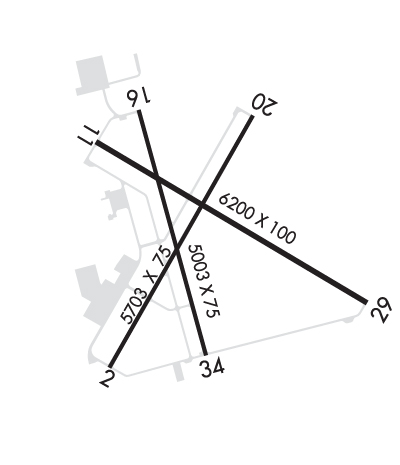
| Lat: N 3155.3 Long: W 10223.2 Elev: 3004 Var: -08 Longest Runway: 6200 | ||
| Clr Del: 121.7 AWOS: 119.27 CTAF: 123.0 | ||
| ||||||||||||||||||||||||||||||||||||||||||||
| ||||||||||||||||||||||||||||||||||||||||||||
| ||||||||||||||||||||||||||||||||||||||||||||
| Rwy | Rwy | |||||||
| 5703x75 | 5703' | 5703x75 | 5703' | |||||
| 6200x100 | 6200' | 6200x100 | 6200' | |||||
| 5003x75 | 5003' | 5003x75 | 5003' | |||||
| Runway ID | Single Wheel | Double Wheel | Double Tandem Wheel | Dual Double Wheel |
| 02/20 | 14,000 | N/A | N/A | N/A |
| 11/29 | 30,000 | N/A | N/A | N/A |
| 16/34 | 14,000 | N/A | N/A | N/A |
| These numbers are Advisory and are not limits. The Airport Manager should have more accurate Weight Limits | ||||
 Airport Diagram might not be current. | |
| Facility Name: | ODESSA-SCHLEMEYER FLD |
| City Name: | ODESSA |
| County: | ECTOR |
| State abbrev: | TX |
| State Name: | TEXAS |
| Ownership: | PUBLICLY OWNED |
| Use: | OPEN TO THE PUBLIC |
| Owner's Name: | ECTOR COUNTY |
| Address: | ECTOR CO COURTHOUSE ANNEX, 1010 EAST 8TH ST |
| ODESSA, TX 79761 | |
| Owner's Phone: | 432-498-4100 |
| Manager's Name: | DAVID PECK |
| Address: | 1010 E. 8TH, ROOM 116 |
| ODESSA, TX 79761 | |
| Phone: | (432) 498-4040 |
| FAA Region: | SOUTHWEST |
| FAA Field Office: | TEX |
| Date | Sunrise | Sunset |
|---|---|---|
| 09/24/21 Friday | 7:39 | 19:44 |
| 09/25/21 Saturday | 7:39 | 19:42 |
| 09/26/21 Sunday | 7:40 | 19:41 |
| 09/27/21 Monday | 7:41 | 19:40 |
| 09/28/21 Tuesday | 7:41 | 19:39 |
| 09/29/21 Wednesday | 7:42 | 19:37 |
| 09/30/21 Thursday | 7:43 | 19:36 |
| 10/01/21 Friday | 7:43 | 19:35 |
| 10/02/21 Saturday | 7:44 | 19:33 |
| 10/03/21 Sunday | 7:45 | 19:32 |
| 10/04/21 Monday | 7:45 | 19:31 |
| 10/05/21 Tuesday | 7:46 | 19:30 |
| 10/06/21 Wednesday | 7:47 | 19:28 |
| 10/07/21 Thursday | 7:47 | 19:27 |
| Airport Attendance Schedule | 7 Days A Week 0600-2000 |
| Airport Status | OPERATIONAL (This Status can change at any time - please check NOTAMS) |
| Airport Lighting Schedule | MIRL RWYS 02/20, 11/29 & 16/34 PRESET LOW INTST; TO INCR INTST ACTVT - CTAF. |
| Airport Storage Available | Tie Downs, Hanger |
| Extra Services Available | Flight Instruction, Aircraft Rental |
| Wind Indicator | YES - (lighted) |
| Control Tower | NO |
| CTAF Frequency | 123.000 |
| Unicom Frequency | 123.000 |
| Rotating Beacon Color | CLEAR-GREEN (Light Land Airport) |
| Segmented Circle | YES |
| Landing Fee | NO |
| Airport Inspected | STATE - performed by STATE AERONAUTICAL PERSONNEL |
| Inspection Date | 01/04/2018 |
| Type of Fuel Available | Grade 100LL, JET A (freeze point -40C); -10FOR FUEL AFT HRS CALL 432-367-5881 OR SELF SERVE |
| Airframe Repair Service | MAJOR |
| Power Plant Repair Service | MAJOR |
| Latitude | N3155.3 |
| Longitude | W10223.2 (ESTIMATED) |
| Arpt Elevation | 3003ft (SURVEYED) |
| Magnetic Variation | 08E |
| 5 miles NE | of ODESSA |
| Traffic Pattern Altitude | |
| Sectional Chart | SAN ANTONIO |
| Operations (Reported) | Yearly | Avg. Daily |
|---|---|---|
| General Aviation Transient | 26000 | 71 |
| General Aviation Local | 52000 | 142 |
| Air Taxi | 0 | 0 |
| Commerical | 0 | 0 |
| Commuter | 0 | 0 |
| Military | 0 | 0 |
| Aircraft based on Field | |
|---|---|
| General Aviation Singles | 81 |
| General Aviation Multi | 14 |
| Jet Aircraft | 11 |
| General Aviation Helicopters | 1 |
| Military Aircraft | 0 |
| Gliders | 0 |
| Ultralights | 0 |
| FSS on field | NO |
| FSS tie-in | SAN ANGELO |
| FSS Phone | 1-800-WX-BRIEF |
| Who issues Notams | ODO |
| Notam D service at airport | YES |
| ARTCC Name | FORT WORTH |
| Airport Certification | |
| Aircraft Rescue & Firefighting Index | None |
| Airport of Entry | No |
| Custom Landing Rights | No |
| Joint Civil/Military | No |
| Military Landing rights | YES |
| NATIONAL PLAN OF INTEGRATED AIRPORT SYSTEMS (NPIAS) |
| GRANT AGREEMENTS UNDER FAAP/ADAP/AIP |
| ASSURANCES PURSUANT TO TITLE VI, CIVIL RIGHTS ACT OF 1964 |
| 340 FT AGL OBSTRUCTION TOWER 2.2 NM SW OF ARPT LGTS OTS. |
| FOR CD CTC MIDLAND APCH AT 432-563-2123. WHEN APCH CLSD CTC FORT WORTH ARTCC AT 817-858-7584. |
Airport Communications & Frequencies:
| |||||||||||||||||||
| Runway: 02 | Runway: 20 | ||
| Mag heading: | 22° | Mag heading: | 202° |
| Rwy Slope: | .90% Up | Rwy Slope: | -.90% Down |
| Approach: | Approach: | ||
| Pattern: | Left Traffic | Pattern: | Left Traffic |
| Markings: | NONPRECISION INSTRUMENT | Markings: | NONPRECISION INSTRUMENT |
| Marking Condition: | GOOD | Marking Condition: | GOOD |
| Arresting Dev: | Arresting Dev: | ||
| Lat & Long: | N3154.8 W10223.6 | Lat. & Long.: | N3155.7 W10223.0 |
| Elev: | 2952.4 ft. MSL | Elev: | 3003.6 ft. MSL |
| TCH: | 38 ft. AGL | TCH: | 38 ft. AGL |
| Visual Glide Path: | 3.00 degrees | Visual Glide Path: | 3.00 degrees |
| Displaced Threshold: | No | Displaced Threshold: | No |
| Touchdown Zone: | YES | Touchdown Zone: | YES |
| Touchdown Elev.: | 2970.8 feet | Touchdown Elev.: | 3003.6 feet |
| Visual Glide Slope: | PULSATING/STEADY BURNING VASI ON LEFT SIDE OF RUNWAY; PSIL OTS INDEFLY. | Visual Glide Slope: | PULSATING/STEADY BURNING VASI ON LEFT SIDE OF RUNWAY; PSIL OTS INDEFLY. |
| RVR Equipment: | RVR Equipment: | ||
| RVV Equipment: | NO | RVV Equipment: | NO |
| Approach Lights: | Approach Lights: | ||
| REIL: | NO | REIL: | NO |
| Centerline Lights: | NO | Centerline Lights: | NO |
| Touchdown lights: | NO | Touchdown lights: | NO |
| Runway Category: | Runway with a Visual Approach | Runway Category: | Runway with a Non-precision Approach having visibility minimums greater than 3/4 mile |
| Declared Distances: | Declared Distances: | ||
| Obstructions: | ROAD | Obstructions: | PLINE |
| Marked: | NOT Marked/Lighted | Marked: | NOT Marked/Lighted |
| Clearance slope: | 20:1 | Clearance slope: | 34:1 |
| Obstruction height: | 15 feet AGL | Obstruction height: | 30 feet AGL |
| Dist. from runway: | 500 feet | Dist. from runway: | 1220 feet |
| Centerline offset: | 270 left of centerline | Centerline offset: | 310 feet right of centerline |
| Comments: | Comments: |
| Runway: 11 | Runway: 29 | ||
| Mag heading: | 113° | Mag heading: | 293° |
| Rwy Slope: | .10% Up | Rwy Slope: | -.10% Down |
| Approach: | Approach: | ||
| Pattern: | Left Traffic | Pattern: | Left Traffic |
| Markings: | NONPRECISION INSTRUMENT | Markings: | NONPRECISION INSTRUMENT |
| Marking Condition: | GOOD | Marking Condition: | GOOD |
| Arresting Dev: | Arresting Dev: | ||
| Lat & Long: | N3155.6 W10223.6 | Lat. & Long.: | N3155.1 W10222.6 |
| Elev: | 2973.5 ft. MSL | Elev: | 2979.5 ft. MSL |
| TCH: | 40 ft. AGL | TCH: | 40 ft. AGL |
| Visual Glide Path: | 3.00 degrees | Visual Glide Path: | 3.00 degrees |
| Displaced Threshold: | No | Displaced Threshold: | No |
| Touchdown Zone: | YES | Touchdown Zone: | YES |
| Touchdown Elev.: | 2975.9 feet | Touchdown Elev.: | 2979.5 feet |
| Visual Glide Slope: | 4-Light PAPI on LEFT side of Runway; PAPI OTS INDEFLY. | Visual Glide Slope: | 4-Light PAPI on LEFT side of Runway; PAPI OTS INDEFLY. |
| RVR Equipment: | RVR Equipment: | ||
| RVV Equipment: | NO | RVV Equipment: | NO |
| Approach Lights: | Approach Lights: | ||
| REIL: | NO | REIL: | NO |
| Centerline Lights: | NO | Centerline Lights: | NO |
| Touchdown lights: | NO | Touchdown lights: | NO |
| Runway Category: | D | Runway Category: | D |
| Declared Distances: | Declared Distances: | ||
| Obstructions: | TREES; + 7 FT TREES 200 FT FM THR; 246 FT LEFT. | Obstructions: | PLINE |
| Marked: | NOT Marked/Lighted | Marked: | MARKED |
| Clearance slope: | Clearance slope: | 38:1 | |
| Obstruction height: | 7 feet AGL | Obstruction height: | 30 feet AGL |
| Dist. from runway: | 200 feet | Dist. from runway: | 1350 feet |
| Centerline offset: | 284 right of centerline | Centerline offset: | 246 feet left of centerline |
| Comments: | 6 FT SCT BRUSH 150 FT TO 200 FT FM THR, 300 FT RIGHT. | Comments: | 6 FT SCATTERED BRUSH 78 FT - 200 FT FM THR, 312 LEFT; 4 FT BOULDERS 78 FT - 200 FT FM THR, 246 FT RIGHT. |
| Runway: 16 | Runway: 34 | ||
| Mag heading: | 157° | Mag heading: | 337° |
| Rwy Slope: | -.57% Down | Rwy Slope: | .57% Up |
| Approach: | Approach: | ||
| Pattern: | Left Traffic | Pattern: | Left Traffic |
| Markings: | NONPRECISION INSTRUMENT | Markings: | NONPRECISION INSTRUMENT |
| Marking Condition: | GOOD | Marking Condition: | GOOD |
| Arresting Dev: | Arresting Dev: | ||
| Lat & Long: | N3155.7 W10223.4 | Lat. & Long.: | N3154.9 W10223.2 |
| Elev: | 2986.6 ft. MSL | Elev: | 2958.2 ft. MSL |
| TCH: | 49 ft. AGL | TCH: | 39 ft. AGL |
| Visual Glide Path: | 4.00 degrees | Visual Glide Path: | 4.00 degrees |
| Displaced Threshold: | No | Displaced Threshold: | No |
| Touchdown Zone: | YES | Touchdown Zone: | YES |
| Touchdown Elev.: | 2986.6 feet | Touchdown Elev.: | 2971.7 feet |
| Visual Glide Slope: | 2-Light PAPI on LEFT side of Runway; PAPI OTS INDEFLY. | Visual Glide Slope: | 2-Light PAPI on LEFT side of Runway; PAPI OTS INDEFLY. |
| RVR Equipment: | RVR Equipment: | ||
| RVV Equipment: | NO | RVV Equipment: | NO |
| Approach Lights: | Approach Lights: | ||
| REIL: | NO | REIL: | NO |
| Centerline Lights: | NO | Centerline Lights: | NO |
| Touchdown lights: | NO | Touchdown lights: | NO |
| Runway Category: | Runway with a Visual Approach | Runway Category: | Runway with a Visual Approach |
| Declared Distances: | Declared Distances: | ||
| Obstructions: | ANT | Obstructions: | PLINE |
| Marked: | NOT Marked/Lighted | Marked: | MARKED |
| Clearance slope: | 20:1 | Clearance slope: | 25:1 |
| Obstruction height: | 45 feet AGL | Obstruction height: | 30 feet AGL |
| Dist. from runway: | 1104 feet | Dist. from runway: | 960 feet |
| Centerline offset: | 185 left of centerline | Centerline offset: | |
| Comments: | Comments: |
Thanks for using FltPlan.com
all rights reserved © 1999-2021 by Flight Plan LLC