
| A L MANGHAM JR. RGNL NACOGDOCHES TX |
| |
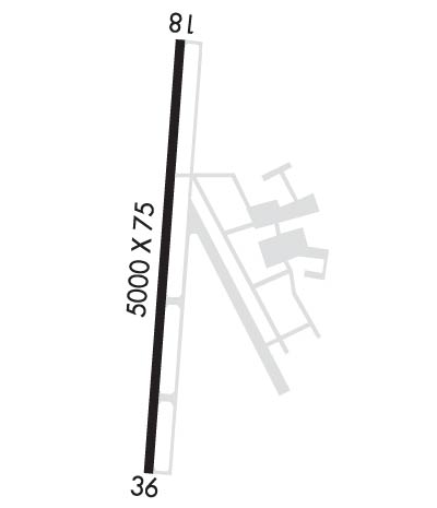
| Lat: N 3134.7 Long: W 09442.6 Elev: 355 Var: -05 Longest Runway: 5000 | ||
| AWOS: 135.62 CTAF: 123.0 | ||
| ||||||||||||||||||||||||||||||||||||||||||||
| ||||||||||||||||||||||||||||||||||||||||||||
| ||||||||||||||||||||||||||||||||||||||||||||
| Rwy | Rwy | |||||||
| 5000x75 | 5000' | 5000x75 | 5000' | 111.50 - 359° | ||||
| Runway ID | Single Wheel | Double Wheel | Double Tandem Wheel | Dual Double Wheel |
| 18/36 | 23,600 | N/A | N/A | N/A |
| These numbers are Advisory and are not limits. The Airport Manager should have more accurate Weight Limits | ||||
 Airport Diagram might not be current. | |
| Facility Name: | NACOGDOCHES A L MANGHAM JR RGNL |
| City Name: | NACOGDOCHES |
| County: | NACOGDOCHES |
| State abbrev: | TX |
| State Name: | TEXAS |
| Ownership: | PUBLICLY OWNED |
| Use: | OPEN TO THE PUBLIC |
| Owner's Name: | CITY OF NACOGDOCHES |
| Address: | PO BOX 635030 |
| NACOGDOCHES, TX 75963-5030 | |
| Owner's Phone: | 936-559-2502 |
| Manager's Name: | JOE CEFALU |
| Address: | 556 TERRY CRAWFORD, OFC |
| NACOGDOCHES, TX 75964 | |
| Phone: | 936-585-3660 |
| FAA Region: | SOUTHWEST |
| FAA Field Office: | TEX |
| Date | Sunrise | Sunset |
|---|---|---|
| 09/24/21 Friday | 7:08 | 19:13 |
| 09/25/21 Saturday | 7:09 | 19:12 |
| 09/26/21 Sunday | 7:09 | 19:11 |
| 09/27/21 Monday | 7:10 | 19:09 |
| 09/28/21 Tuesday | 7:11 | 19:08 |
| 09/29/21 Wednesday | 7:11 | 19:07 |
| 09/30/21 Thursday | 7:12 | 19:05 |
| 10/01/21 Friday | 7:12 | 19:04 |
| 10/02/21 Saturday | 7:13 | 19:03 |
| 10/03/21 Sunday | 7:14 | 19:02 |
| 10/04/21 Monday | 7:14 | 19:00 |
| 10/05/21 Tuesday | 7:15 | 18:59 |
| 10/06/21 Wednesday | 7:16 | 18:58 |
| 10/07/21 Thursday | 7:16 | 18:57 |
| Airport Attendance Schedule | 7 Days A Week 0800-1700 |
| Airport Status | OPERATIONAL (This Status can change at any time - please check NOTAMS) |
| Airport Lighting Schedule | MIRL RWY 18/36 PRESET LOW INTST; TO INCR INTST & ACTVT MALSR RWY 36, REIL RWY 18 - CTAF. |
| Airport Storage Available | Tie Downs |
| Extra Services Available | Flight Instruction, Aircraft Rental |
| Wind Indicator | YES - (lighted) |
| Control Tower | NO |
| CTAF Frequency | 123.000 |
| Unicom Frequency | 123.000 |
| Rotating Beacon Color | CLEAR-GREEN (Light Land Airport) |
| Segmented Circle | YES |
| Landing Fee | NO |
| Airport Inspected | STATE - performed by STATE AERONAUTICAL PERSONNEL |
| Inspection Date | 09/24/2019 |
| Type of Fuel Available | Grade 100LL, JET A (freeze point -40C); -1024 HR SELF SERVE WITH MAJOR CREDIT CARD; FUEL AVBL FM TRUCK. FOR FUEL AFT HRS CALL 936-645-8760; OTHER NRS POSTED AT ARPT. |
| Airframe Repair Service | MAJOR |
| Power Plant Repair Service | MAJOR |
| Latitude | N3134.7 |
| Longitude | W09442.6 (ESTIMATED) |
| Arpt Elevation | 354ft (SURVEYED) |
| Magnetic Variation | 05E |
| 3 miles SW | of NACOGDOCHES |
| Traffic Pattern Altitude | |
| Sectional Chart | HOUSTON |
| Operations (Reported) | Yearly | Avg. Daily |
|---|---|---|
| General Aviation Transient | 7500 | 21 |
| General Aviation Local | 22500 | 62 |
| Air Taxi | 0 | 0 |
| Commerical | 0 | 0 |
| Commuter | 0 | 0 |
| Military | 300 | 1 |
| Aircraft based on Field | |
|---|---|
| General Aviation Singles | 49 |
| General Aviation Multi | 8 |
| Jet Aircraft | 2 |
| General Aviation Helicopters | 1 |
| Military Aircraft | 0 |
| Gliders | 0 |
| Ultralights | 0 |
| FSS on field | NO |
| FSS tie-in | MONTGOMERY COUNTY |
| FSS Phone | 1-800-WX-BRIEF |
| Who issues Notams | OCH |
| Notam D service at airport | YES |
| ARTCC Name | FORT WORTH |
| Airport Certification | |
| Aircraft Rescue & Firefighting Index | None |
| Airport of Entry | No |
| Custom Landing Rights | No |
| Joint Civil/Military | No |
| Military Landing rights | YES |
| NATIONAL PLAN OF INTEGRATED AIRPORT SYSTEMS (NPIAS) |
| GRANT AGREEMENTS UNDER FAAP/ADAP/AIP |
| ASSURANCES PURSUANT TO TITLE VI, CIVIL RIGHTS ACT OF 1964 |
| 35 FT AGL ANT 400 FT WEST OF CNTRLN RWY 18/36. |
| BIRDS ON AND INVOF ARPT. |
| FOR CD CTC HOUSTON ARTCC AT 281-230-5622. |
| RWY 18/3 6 NO LN OF SIGHT BTN THRS. |
Airport Communications & Frequencies:
| |||||||||
| Runway: 18 | Runway: 36 | ||
| Mag heading: | 179° | Mag heading: | 359° |
| Rwy Slope: | -.21% Down | Rwy Slope: | .21% Up |
| Approach: | Approach: | ILS/DME | |
| Pattern: | Left Traffic | Pattern: | Left Traffic |
| Markings: | NONPRECISION INSTRUMENT | Markings: | NONPRECISION INSTRUMENT |
| Marking Condition: | GOOD | Marking Condition: | GOOD |
| Arresting Dev: | Arresting Dev: | ||
| Lat & Long: | N3135.1 W09442.6 | Lat. & Long.: | N3134.3 W09442.6 |
| Elev: | 337.3 ft. MSL | Elev: | 326.6 ft. MSL |
| TCH: | 37 ft. AGL | TCH: | 53 ft. AGL |
| Visual Glide Path: | 3.00 degrees | Visual Glide Path: | 3.00 degrees |
| Displaced Threshold: | No | Displaced Threshold: | No |
| Touchdown Zone: | YES | Touchdown Zone: | YES |
| Touchdown Elev.: | 343.1 feet | Touchdown Elev.: | 343.1 feet |
| Visual Glide Slope: | 2-Light PAPI on LEFT side of Runway | Visual Glide Slope: | 2-Light PAPI on LEFT side of Runway |
| RVR Equipment: | RVR Equipment: | ||
| RVV Equipment: | NO | RVV Equipment: | NO |
| Approach Lights: | Approach Lights: | MALSR - 1,400 foot medium intensity approach lighting system with runway alignment indicator lights | |
| REIL: | YES | REIL: | NO |
| Centerline Lights: | NO | Centerline Lights: | NO |
| Touchdown lights: | NO | Touchdown lights: | NO |
| Runway Category: | Runway with a Non-precision Approach having visibility minimums greater than 3/4 mile | Runway Category: | Precision Instrument Runway |
| Declared Distances: | Declared Distances: | ||
| Obstructions: | TREES | Obstructions: | TREES |
| Marked: | NOT Marked/Lighted | Marked: | NOT Marked/Lighted |
| Clearance slope: | Clearance slope: | 36:1 | |
| Obstruction height: | 54 feet AGL | Obstruction height: | 73 feet AGL |
| Dist. from runway: | 210 feet | Dist. from runway: | 2894 feet |
| Centerline offset: | 500 left of centerline | Centerline offset: | 303 feet left of centerline |
| Comments: | +54 FT TREES FM THR TO 200 FT FM THR AT 500 FT LEFT. | Comments: | 10-40 FT TREES 85-200 FT FM THR 490 FT LEFT; 40 FT TREES 75-120 FT FM THR 485 FT RIGHT. |
Thanks for using FltPlan.com
all rights reserved © 1999-2021 by Flight Plan LLC
