
| METROPOLITAN OAKLAND INTL OAKLAND CA |
| |
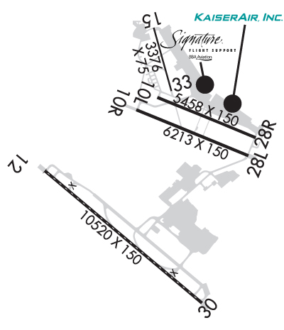
| Lat: N 3743.3 Long: W 12213.3 Elev: 9 Var: -14 Longest Runway: 10520 | ||
| Clr Del: 121.1 Dept. ATIS: 133.77 Arr. ATIS: 133.77 Ground: 121.75/121.9 Tower: 127.2/118.3 | ||
| |||||||||||||||||||||||||||||||||||||||||||||||||||||||||||||||||||||
| |||||||||||||||||||||||||||||||||||||||||||||||||||||||||||||||||||||
| |||||||||||||||||||||||||||||||||||||||||||||||||||||||||||||||||||||
| |||||||||||||||||||||||||||||||||||||||||||||||||||||||||||||||||||||
| |||||||||||||||||||||||||||||||||||||||||||||||||||||||||||||||||||||
| FBOs at nearby airports who want your business: | |||||||||||||||||
| |||||||||||||||||
| Rwy | Rwy | |||||||
| 5457x150 | 5457' | 5457x150 | 5457' | 109.90 - 278° | ||||
| 6213x150 | 6213' | 6213x150 | 6213' | |||||
| 10520x150 | 10520' | 111.90 - 115° | 10520x150 | 10406' | 108.70 - 296° | |||
| 3376x75 | 3376' | 3376x75 | 3376' | |||||
| Runway ID | Single Wheel | Double Wheel | Double Tandem Wheel | Dual Double Wheel |
| 10L/28R | 120,000 | 250,000 | 550,000 | 1,120,000 |
| 10R/28L | 120,000 | 250,000 | 550,000 | 1,120,000 |
| 12/30 | 120,000 | 250,000 | 550,000 | 1,120,000 |
| 15/33 | 12,500 | 65,000 | 100,000 | N/A |
| These numbers are Advisory and are not limits. The Airport Manager should have more accurate Weight Limits | ||||
 Airport Diagram might not be current. | |
| Facility Name: | OAKLAND SAN FRANCISCO BAY |
| City Name: | OAKLAND |
| County: | ALAMEDA |
| State abbrev: | CA |
| State Name: | CALIFORNIA |
| Ownership: | PUBLICLY OWNED |
| Use: | OPEN TO THE PUBLIC |
| Owner's Name: | PORT OF OAKLAND |
| Address: | 530 WATER ST. |
| OAKLAND, CA 94607 | |
| Owner's Phone: | 510-563-3300 |
| Manager's Name: | MATT DAVIS; OPERATIONS - DARRON EVANS, OPNS SUPERINTENDENT (510)563-6432, CELL: (510) 715-6286 24HR OPERATIONS (510) 563-3361. |
| Address: | OAKLAND INTL ARPT, 1 AIRPORT DRIVE |
| OAKLAND, CA 94621 | |
| Phone: | 510-563-6436 |
| FAA Region: | WESTERN-PACIFIC |
| FAA Field Office: | SFO |

| Date | Sunrise | Sunset |
|---|---|---|
| 06/08/26 Monday | 5:47 | 20:29 |
| 06/09/26 Tuesday | 5:47 | 20:30 |
| 06/10/26 Wednesday | 5:47 | 20:30 |
| 06/11/26 Thursday | 5:47 | 20:31 |
| 06/12/26 Friday | 5:47 | 20:31 |
| 06/13/26 Saturday | 5:46 | 20:31 |
| 06/14/26 Sunday | 5:46 | 20:32 |
| 06/15/26 Monday | 5:47 | 20:32 |
| 06/16/26 Tuesday | 5:47 | 20:33 |
| 06/17/26 Wednesday | 5:47 | 20:33 |
| 06/18/26 Thursday | 5:47 | 20:33 |
| 06/19/26 Friday | 5:47 | 20:33 |
| 06/20/26 Saturday | 5:47 | 20:34 |
| 06/21/26 Sunday | 5:47 | 20:34 |
| Airport Attendance Schedule | CONTINUOUS |
| Airport Status | OPERATIONAL (This Status can change at any time - please check NOTAMS) |
| Airport Lighting Schedule | |
| Airport Storage Available | Tie Downs |
| Extra Services Available | Air Freight, Avionics, Cargo Handling, Charter, Flight Instruction, Aircraft Rental, Aircraft Sales |
| Wind Indicator | YES - (lighted) |
| Control Tower | YES |
| CTAF Frequency | |
| Unicom Frequency | 122.950 |
| Rotating Beacon Color | WG |
| Segmented Circle | NO |
| Landing Fee | YES; LDG FEE IN EFCT 24 HRS/DAY, CTC AIRFIELD OPS (510) 563-3361. |
| Airport Inspected | FEDERAL - performed by FAA AIRPORTS FIELD PERSONNEL |
| Inspection Date | 05/16/2025 |
| Type of Fuel Available | Grade 100LL, JET A (freeze point -40C) |
| Airframe Repair Service | MAJOR |
| Power Plant Repair Service | MAJOR |
| Latitude | N3743.3 |
| Longitude | W12213.3 (ESTIMATED) |
| Arpt Elevation | 9ft (SURVEYED) |
| Magnetic Variation | 14E |
| 4 miles S | of OAKLAND |
| Traffic Pattern Altitude | TFC PAT ALT RWY 28L 606' MSL; RWY 28R 1006' MSL. |
| Sectional Chart | SAN FRANCISCO |
| Operations (Reported) | Yearly | Avg. Daily |
|---|---|---|
| General Aviation Transient | 0 | 0 |
| General Aviation Local | 0 | 0 |
| Air Taxi | 0 | 0 |
| Commerical | 0 | 0 |
| Commuter | 0 | 0 |
| Military | 0 | 0 |
| Aircraft based on Field | |
|---|---|
| General Aviation Singles | 0 |
| General Aviation Multi | 0 |
| Jet Aircraft | 0 |
| General Aviation Helicopters | 0 |
| Military Aircraft | 0 |
| Gliders | 0 |
| Ultralights | 0 |
| FSS on field | NO |
| FSS tie-in | OAKLAND |
| FSS Phone | 1-800-WX-BRIEF |
| Who issues Notams | OAK |
| Notam D service at airport | YES |
| ARTCC Name | OAKLAND |
| Airport Certification | AIRPORT RECEIVING SCHEDULED AIR CARRIER SERVICE FROM CARRIERS CERTIFICATED BY THE CIVIL AERONAUTICS BOARD |
| Aircraft Rescue & Firefighting Index | AIRPORT HAS A CERTIFICATE UNDER CFR PART 139 |
| Airport of Entry | No |
| Custom Landing Rights | YES |
| Joint Civil/Military | No |
| Military Landing rights | YES |
| NATIONAL PLAN OF INTEGRATED AIRPORT SYSTEMS (NPIAS) |
| GRANT AGREEMENTS UNDER FAAP/ADAP/AIP |
| SURPLUS PROPERTY AGREEMENT UNDER PUBLIC LAW 289 |
| ASSURANCES PURSUANT TO TITLE VI, CIVIL RIGHTS ACT OF 1964 |
| BIRDS ON & INVOF ARPT. |
| RWYS 30, 28R AND RWY 28L DIST RMNG SIGNS L SIDE. |
| FOR NOISE ABATEMENT INFO CTC NOISE ABATEMENT OFC AT 510-563-6463 OR VISIT ARPT WEBSITE. |
| 24 HR NOISE ABATEMENT PROC: TBJT AND TURBOFAN PWRD ACFT, TURBOROPS OVER 17000 LBS, FOUR-ENG RECIPROCATING PWRD ACFT, AND SURPLUS MIL ACFT OVER 12500 LBS SHOULD USE RWY 12/30. |
| TWY A, E, G, H BTN RWY 28R AND TWY C MAX ACFT WT 150,000 LBS. |
| TWY G & H BTN RWY 28L & 28R: MAX ACFT WT 12,500 LBS. |
| TWY P MAX ACFT WT 116,000 LBS SINGLE; 190,000 LBS DUAL; 305,000 LBS DUAL TANDEM; 735,000 LBS DOUBLE DUAL TANDEM. |
| TWY C BTN RWY 28R & TWY G AND TWYS B, J, AND D MAX ACFT WT 861,000 LBS. |
| TWY C BTN TWY G & J MAX ACFT WEIGHT 90,000 LBS SINGLE; 144,000 LBS DUAL; 257,000 LBS TANDEM. |
| TWY C BTN TWY J & F MAX ACFT WEIGHT 76,000 LBS SINGLE; 115,000 LBS DUAL; 257,000 LBS TANDEM (DUAL TANDEM NA). |
| TWY K BTN TWY D & INT TWYS F, L, K MAX ACFT WEIGHT 56,000 LBS SINGLE; 70,000 LBS DUAL; 130,000 LBS TANDEM. |
| TWY K BTN TWY J AND INT TWYS F, L, K MAX ACFT WT 33000 LBS SINGLE; 45000 LBS DUAL; TANDEM NA. |
| 400 FT BY 220 FT BLAST PAD RWY 12 AND RWY 30. |
| UNDERLIES CLASS B ASP, BE AWARE OF SPEEDS ON ARR AND DEP. |
| NOISE ABATEMENT PROCS N/A IN EMERGS OR WHENEVER RWY 12/30 IS UNAVBL DUE TO MAINT, SAFETY, WINDS OR WX. |
| ACFT WITH EXPERIMENTAL OR LTD CERTIF HAVING OVER 1000 HORSEPOWER OR 4000 LBS ARE RSTRD TO RWY 12/30. |
| 100 FT LGTD MICROWAVE ANT TWR LCTD 1320 FT WSW OF OAK VORTAC; S OF UPWIND END OF RWY 28L. |
| RWY 15/3 3 RWY 15/33 NOT AVBL FOR PART 121/PART 380 OPS WITH SKED PAX CARRYING OPS MORE THAN 9 PAX SEATS AND NON-SKED PAX CARRYING OPS MORE THAN 30 PAX SEATS. |
| RWY 10L/ 28RPCR VALUE: 1266/F/B/X/T |
| RWY 10R/ 28LPCR VALUE: 934/F/B/X/T |
| RWY 12/3 0 PCR VALUE: 1295/F/B/X/T |
Airport Communications & Frequencies:
| |||||||||||||||||||||||||||||||||||||||||||||||||||||||||||||||||||||||||||||||||
| Runway: 10L | Runway: 28R | ||
| Mag heading: | 98° | Mag heading: | 278° |
| Rwy Slope: | .01% Up | Rwy Slope: | -.01% Down |
| Approach: | Approach: | ILS | |
| Pattern: | Left Traffic | Pattern: | Right Traffic |
| Markings: | NONPRECISION INSTRUMENT | Markings: | PRECISION INSTRUMENT |
| Marking Condition: | GOOD | Marking Condition: | GOOD |
| Arresting Dev: | Arresting Dev: | ||
| Lat & Long: | N3743.8 W12213.3 | Lat. & Long.: | N3743.5 W12212.3 |
| Elev: | 5.5 ft. MSL | Elev: | 5.8 ft. MSL |
| TCH: | 50 ft. AGL | TCH: | 51 ft. AGL |
| Visual Glide Path: | 3.00 degrees | Visual Glide Path: | 3.00 degrees |
| Displaced Threshold: | No | Displaced Threshold: | No |
| Touchdown Zone: | YES | Touchdown Zone: | YES |
| Touchdown Elev.: | 6.3 feet | Touchdown Elev.: | 6.8 feet |
| Visual Glide Slope: | 4-Light PAPI on RIGHT side of Runway | Visual Glide Slope: | 4-Light PAPI on LEFT side of Runway |
| RVR Equipment: | ROLLOUT | RVR Equipment: | TOUCHDOWN |
| RVV Equipment: | NO | RVV Equipment: | YES |
| Approach Lights: | Approach Lights: | MALSR - 1,400 foot medium intensity approach lighting system with runway alignment indicator lights | |
| REIL: | NO | REIL: | NO |
| Centerline Lights: | NO | Centerline Lights: | NO |
| Touchdown lights: | NO | Touchdown lights: | NO |
| Runway Category: | Runway with a Non-precision Approach having visibility minimums greater than 3/4 mile | Runway Category: | Precision Instrument Runway |
| Declared Distances: | TORA:5457' TODA:5457' ASDA:5336' LDA:5336' | Declared Distances: | TORA:5457' TODA:5457' ASDA:5457' LDA:5457' |
| Obstructions: | Obstructions: | BLDG | |
| Marked: | Marked: | LIGHTED | |
| Clearance slope: | 50:1 | Clearance slope: | 30:1 |
| Obstruction height: | Obstruction height: | 11 feet AGL | |
| Dist. from runway: | Dist. from runway: | 530 feet | |
| Centerline offset: | Centerline offset: | 480 feet right of centerline | |
| Comments: | Comments: |
| Runway: 10R | Runway: 28L | ||
| Mag heading: | 98° | Mag heading: | 278° |
| Rwy Slope: | .00% Up | Rwy Slope: | .00% Down |
| Approach: | Approach: | ||
| Pattern: | Left Traffic | Pattern: | Left Traffic |
| Markings: | NONPRECISION INSTRUMENT | Markings: | PRECISION INSTRUMENT |
| Marking Condition: | GOOD | Marking Condition: | GOOD |
| Arresting Dev: | Arresting Dev: | EMAS; ENGINEERED MATERIALS ARRESTING SYSTEM (EMAS) 162 FT IN LENGTH BY 154 FT IN WIDTH LCTD AT THE DER 28L. | |
| Lat & Long: | N3743.7 W12213.6 | Lat. & Long.: | N3743.3 W12212.4 |
| Elev: | 8.0 ft. MSL | Elev: | 8.2 ft. MSL |
| TCH: | 50 ft. AGL | TCH: | 50 ft. AGL |
| Visual Glide Path: | 3.00 degrees | Visual Glide Path: | 3.00 degrees |
| Displaced Threshold: | No | Displaced Threshold: | No |
| Touchdown Zone: | YES | Touchdown Zone: | YES |
| Touchdown Elev.: | 8.9 feet | Touchdown Elev.: | 8.6 feet |
| Visual Glide Slope: | 4-Light PAPI on LEFT side of Runway | Visual Glide Slope: | 4-Light PAPI on RIGHT side of Runway |
| RVR Equipment: | RVR Equipment: | ||
| RVV Equipment: | NO | RVV Equipment: | YES |
| Approach Lights: | Approach Lights: | ||
| REIL: | YES | REIL: | NO |
| Centerline Lights: | NO | Centerline Lights: | NO |
| Touchdown lights: | NO | Touchdown lights: | NO |
| Runway Category: | Runway with a Non-precision Approach having visibility minimums greater than 3/4 mile | Runway Category: | D |
| Declared Distances: | TORA:6213' TODA:6213' ASDA:6213' LDA:6213' | Declared Distances: | TORA:6213' TODA:6213' ASDA:6213' LDA:6213' |
| Runway: 12 | Runway: 30 | ||
| Mag heading: | 116° | Mag heading: | 296° |
| Rwy Slope: | .01% Up | Rwy Slope: | -.01% Down |
| Approach: | ILS | Approach: | ILS/DME |
| Pattern: | Right Traffic | Pattern: | Left Traffic |
| Markings: | PRECISION INSTRUMENT | Markings: | PRECISION INSTRUMENT |
| Marking Condition: | GOOD | Marking Condition: | GOOD |
| Arresting Dev: | Arresting Dev: | ||
| Lat & Long: | N3743.2 W12214.5 | Lat. & Long.: | N3742.1 W12212.9 |
| Elev: | 8.3 ft. MSL | Elev: | 9.0 ft. MSL |
| TCH: | 70 ft. AGL | TCH: | 71 ft. AGL |
| Visual Glide Path: | 2.75 degrees | Visual Glide Path: | 3.00 degrees |
| Displaced Threshold: | No | Displaced Threshold: | 114 feet |
| Touchdown Zone: | YES | Touchdown Zone: | YES |
| Touchdown Elev.: | 8.6 feet | Touchdown Elev.: | 9.0 feet |
| Visual Glide Slope: | 4-Light PAPI on RIGHT side of Runway | Visual Glide Slope: | 4-Light PAPI on LEFT side of Runway |
| RVR Equipment: | TOUCHDOWN-MIDFIELD-ROLLOUT | RVR Equipment: | TOUCHDOWN-MIDFIELD-ROLLOUT |
| RVV Equipment: | NO | RVV Equipment: | NO |
| Approach Lights: | MALSR - 1,400 foot medium intensity approach lighting system with runway alignment indicator lights | Approach Lights: | ALSF2 - standard 2,400 foot high intensity approach lighting system with sequenced flashers, Category II or III |
| REIL: | NO | REIL: | NO |
| Centerline Lights: | YES | Centerline Lights: | YES |
| Touchdown lights: | NO | Touchdown lights: | YES |
| Runway Category: | Precision Instrument Runway | Runway Category: | Precision Instrument Runway |
| Declared Distances: | TORA:10000' TODA:10000' ASDA:10000' LDA:10000' | Declared Distances: | TORA:10000' TODA:10000' ASDA:10000' LDA:10000' |
| Runway: 15 | Runway: 33 | ||
| Mag heading: | 150° | Mag heading: | 330° |
| Rwy Slope: | .07% Up | Rwy Slope: | -.07% Down |
| Approach: | Approach: | ||
| Pattern: | Left Traffic | Pattern: | Right Traffic |
| Markings: | BASIC | Markings: | BASIC |
| Marking Condition: | GOOD | Marking Condition: | GOOD |
| Arresting Dev: | Arresting Dev: | ||
| Lat & Long: | N3744.4 W12213.4 | Lat. & Long.: | N3743.9 W12213.2 |
| Elev: | 1.4 ft. MSL | Elev: | 3.9 ft. MSL |
| TCH: | TCH: | ||
| Visual Glide Path: | Visual Glide Path: | ||
| Displaced Threshold: | No | Displaced Threshold: | No |
| Touchdown Zone: | YES | Touchdown Zone: | YES |
| Touchdown Elev.: | 4.6 feet | Touchdown Elev.: | 4.6 feet |
| Visual Glide Slope: | Visual Glide Slope: | ||
| RVR Equipment: | RVR Equipment: | ||
| RVV Equipment: | NO | RVV Equipment: | NO |
| Approach Lights: | Approach Lights: | ||
| REIL: | NO | REIL: | NO |
| Centerline Lights: | NO | Centerline Lights: | NO |
| Touchdown lights: | NO | Touchdown lights: | NO |
| Runway Category: | Runway with a Visual Approach | Runway Category: | Runway with a Visual Approach |
| Declared Distances: | Declared Distances: |
Thanks for using FltPlan.com
all rights reserved © 1999-2026 by Flight Plan LLC