
| ALBERT J ELLIS JACKSONVILLE NC |
| |
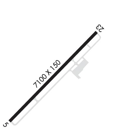
| Lat: N 3449.8 Long: W 07736.7 Elev: 93 Var: +08 Longest Runway: 7100 | ||
| Clr Del: 121.4 twr cld Dept. ATIS: 124.47 Arr. ATIS: 124.47 AWOS: 124.47 Ground: 125.4 Tower: 132.65 | ||
| ||||||||||||||||||||||||||||||||||||||||||||
| ||||||||||||||||||||||||||||||||||||||||||||
| ||||||||||||||||||||||||||||||||||||||||||||
| Rwy | Rwy | |||||||
| 7100x150 | 7100' | 108.70 - 052° | 7100x150 | 7100' | ||||
| Runway ID | Single Wheel | Double Wheel | Double Tandem Wheel | Dual Double Wheel |
| 05/23 | 120,000 | 211,000 | 388,000 | N/A |
| These numbers are Advisory and are not limits. The Airport Manager should have more accurate Weight Limits | ||||
 Airport Diagram might not be current. | |
| Facility Name: | ALBERT J ELLIS |
| City Name: | JACKSONVILLE |
| County: | ONSLOW |
| State abbrev: | NC |
| State Name: | NORTH CAROLINA |
| Ownership: | PUBLICLY OWNED |
| Use: | OPEN TO THE PUBLIC |
| Owner's Name: | ONSLOW COUNTY |
| Address: | 234 NW CORRIDOR BLVD |
| JACKSONVILLE, NC 28540 | |
| Owner's Phone: | 910-347-4717 |
| Manager's Name: | CHRISTOPHER WHITE |
| Address: | 264 ELLIS AIRPORT RD |
| RICHLANDS, NC 28574 | |
| Phone: | 910-324-1100 |
| FAA Region: | SOUTHERN |
| FAA Field Office: | MEM |
| Date | Sunrise | Sunset |
|---|---|---|
| 09/24/21 Friday | 7:00 | 19:05 |
| 09/25/21 Saturday | 7:00 | 19:03 |
| 09/26/21 Sunday | 7:01 | 19:02 |
| 09/27/21 Monday | 7:02 | 19:00 |
| 09/28/21 Tuesday | 7:03 | 18:59 |
| 09/29/21 Wednesday | 7:03 | 18:58 |
| 09/30/21 Thursday | 7:04 | 18:56 |
| 10/01/21 Friday | 7:05 | 18:55 |
| 10/02/21 Saturday | 7:06 | 18:53 |
| 10/03/21 Sunday | 7:06 | 18:52 |
| 10/04/21 Monday | 7:07 | 18:51 |
| 10/05/21 Tuesday | 7:08 | 18:49 |
| 10/06/21 Wednesday | 7:09 | 18:48 |
| 10/07/21 Thursday | 7:10 | 18:47 |
| Airport Attendance Schedule | 7 Days A Week 0500-2400 |
| Airport Status | OPERATIONAL (This Status can change at any time - please check NOTAMS) |
| Airport Lighting Schedule | ACTVT MALSR RWY 05; REIL RWY 23; HIRL RWY 05/23; PAPI RWY 05 & 23 - CTAF. |
| Airport Storage Available | Tie Downs, Hanger |
| Extra Services Available | Flight Instruction, Aircraft Rental, Aircraft Sales |
| Wind Indicator | YES - (lighted) |
| Control Tower | YES |
| CTAF Frequency | 132.650 |
| Unicom Frequency | 122.950 |
| Rotating Beacon Color | CLEAR-GREEN (Light Land Airport) |
| Segmented Circle | YES |
| Landing Fee | NO |
| Airport Inspected | FEDERAL - performed by FAA AIRPORTS FIELD PERSONNEL |
| Inspection Date | 06/25/2019 |
| Type of Fuel Available | Grade 100LL, JET A (freeze point -40C); -10FOR FUEL OTHER HRS CALL 910-347-8366. |
| Airframe Repair Service | MAJOR |
| Power Plant Repair Service | MAJOR |
| Latitude | N3449.8 |
| Longitude | W07736.7 (ESTIMATED) |
| Arpt Elevation | 92ft (SURVEYED) |
| Magnetic Variation | 08W |
| 10 miles NW | of JACKSONVILLE |
| Traffic Pattern Altitude | |
| Sectional Chart | CHARLOTTE |
| Operations (Reported) | Yearly | Avg. Daily |
|---|---|---|
| General Aviation Transient | 5478 | 15 |
| General Aviation Local | 4218 | 12 |
| Air Taxi | 2797 | 8 |
| Commerical | 6722 | 18 |
| Commuter | 0 | 0 |
| Military | 10329 | 28 |
| Aircraft based on Field | |
|---|---|
| General Aviation Singles | 22 |
| General Aviation Multi | 1 |
| Jet Aircraft | 0 |
| General Aviation Helicopters | 3 |
| Military Aircraft | 0 |
| Gliders | 0 |
| Ultralights | 0 |
| FSS on field | NO |
| FSS tie-in | RALEIGH |
| FSS Phone | 1-800-WX-BRIEF |
| Who issues Notams | OAJ |
| Notam D service at airport | YES |
| ARTCC Name | WASHINGTON |
| Airport Certification | AIRPORT RECEIVING SCHEDULED AIR CARRIER SERVICE FROM CARRIERS CERTIFICATED BY THE CIVIL AERONAUTICS BOARD; CLSD TO UNSKED ACR OPNS WITH MORE THAN 30 PSGR SEATS EXCP PPR CALL AMGR 910-324-1100 OR 910-989-3168. |
| Aircraft Rescue & Firefighting Index | AIRPORT HAS A CERTIFICATE UNDER CFR PART 139 |
| Airport of Entry | No |
| Custom Landing Rights | No |
| Joint Civil/Military | No |
| Military Landing rights | YES |
| NATIONAL PLAN OF INTEGRATED AIRPORT SYSTEMS (NPIAS) |
| GRANT AGREEMENTS UNDER FAAP/ADAP/AIP |
| ASSURANCES PURSUANT TO TITLE VI, CIVIL RIGHTS ACT OF 1964 |
| 180 DEG TURNS ON RWY 05/23 NA FOR ACFT 60000 LBS AND OVER. |
| CLSD TO ALL MIL ACFT OVER 17000 LBS FOR ACR RAMP OPNS EXCP 24 HR PPR. CALL AMGR 910-324-1100 OR 910-989-3168. |
| INDEX B ARFF COVERAGE PROVIDED DURING COMMERCIAL AIR TRC OPS. INDEX C AVAILABLE UPON REQ. |
| FIELD CONDITIONS NOT MONITORED 0000LCL-0500LCL DAILY |
| FOR CD WHEN ATCT CLSD, CTC WILMINGTON APCH AT 910-815-4676, OR WHEN APCH CLSD CTC WASHINGTON ARTCC AT 703-771-3587. |
Airport Communications & Frequencies:
| |||||||||||||||||||||||||||||
| Runway: 05 | Runway: 23 | ||
| Mag heading: | 52° | Mag heading: | 232° |
| Rwy Slope: | .02% Up | Rwy Slope: | -.02% Down |
| Approach: | ILS/DME | Approach: | |
| Pattern: | Left Traffic | Pattern: | Left Traffic |
| Markings: | PRECISION INSTRUMENT | Markings: | PRECISION INSTRUMENT |
| Marking Condition: | GOOD | Marking Condition: | GOOD |
| Arresting Dev: | Arresting Dev: | ||
| Lat & Long: | N3449.3 W07737.2 | Lat. & Long.: | N3450.2 W07736.2 |
| Elev: | 88.9 ft. MSL | Elev: | 90.4 ft. MSL |
| TCH: | 55 ft. AGL | TCH: | 47 ft. AGL |
| Visual Glide Path: | 3.00 degrees | Visual Glide Path: | 3.00 degrees |
| Displaced Threshold: | No | Displaced Threshold: | No |
| Touchdown Zone: | YES | Touchdown Zone: | YES |
| Touchdown Elev.: | 89.4 feet | Touchdown Elev.: | 92.9 feet |
| Visual Glide Slope: | 4-Light PAPI on LEFT side of Runway | Visual Glide Slope: | 4-Light PAPI on LEFT side of Runway |
| RVR Equipment: | RVR Equipment: | ||
| RVV Equipment: | NO | RVV Equipment: | NO |
| Approach Lights: | MALSR - 1,400 foot medium intensity approach lighting system with runway alignment indicator lights | Approach Lights: | |
| REIL: | NO | REIL: | YES |
| Centerline Lights: | NO | Centerline Lights: | NO |
| Touchdown lights: | NO | Touchdown lights: | NO |
| Runway Category: | Precision Instrument Runway | Runway Category: | Precision Instrument Runway |
| Declared Distances: | Declared Distances: |
Thanks for using FltPlan.com
all rights reserved © 1999-2021 by Flight Plan LLC
