| RIO VISTA MUNI RIO VISTA CA |
| |
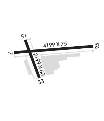
| Lat: N 3811.6 Long: W 12142.2 Elev: 23 Var: -14 Longest Runway: 4199 | ||
| AWOS: 127.07 CTAF: 122.72 | ||
| ||||||||||||||||||||||||||||||||||||||||||||||||||||||||||||||||||||
| ||||||||||||||||||||||||||||||||||||||||||||||||||||||||||||||||||||
| ||||||||||||||||||||||||||||||||||||||||||||||||||||||||||||||||||||
| Rwy | Rwy | |||||||
| 4199x75 | 4199' | 4199x75 | 4199' | |||||
| 2199x60 | 2199' | 2199x60 | 2199' | |||||
| Runway ID | Single Wheel | Double Wheel | Double Tandem Wheel | Dual Double Wheel |
| 07/25 | 30,000 | N/A | N/A | N/A |
| 15/33 | 12,500 | N/A | N/A | N/A |
| H1 | N/A | N/A | N/A | N/A |
| These numbers are Advisory and are not limits. The Airport Manager should have more accurate Weight Limits | ||||
 Airport Diagram might not be current. | |
| Facility Name: | RIO VISTA MUNI |
| City Name: | RIO VISTA |
| County: | SOLANO |
| State abbrev: | CA |
| State Name: | CALIFORNIA |
| Ownership: | PUBLICLY OWNED |
| Use: | OPEN TO THE PUBLIC |
| Owner's Name: | CITY OF RIO VISTA |
| Address: | ONE MAIN STREET |
| RIO VISTA, CA 94571 | |
| Owner's Phone: | 707-374-6451 |
| Manager's Name: | TOM HAVENS; LEAD MAINTENANCE SUPERVISOR |
| Address: | ONE MAIN STREET, P.O. BOX 94571 |
| RIO VISTA, CA 94571 | |
| Phone: | 707-249-7510; AFTER HOURS CALL (707) 249-7510 |
| FAA Region: | WESTERN-PACIFIC |
| FAA Field Office: | SFO |
| Date | Sunrise | Sunset |
|---|---|---|
| 06/08/26 Monday | 5:43 | 20:28 |
| 06/09/26 Tuesday | 5:43 | 20:29 |
| 06/10/26 Wednesday | 5:43 | 20:29 |
| 06/11/26 Thursday | 5:43 | 20:30 |
| 06/12/26 Friday | 5:43 | 20:30 |
| 06/13/26 Saturday | 5:43 | 20:31 |
| 06/14/26 Sunday | 5:43 | 20:31 |
| 06/15/26 Monday | 5:43 | 20:32 |
| 06/16/26 Tuesday | 5:43 | 20:32 |
| 06/17/26 Wednesday | 5:43 | 20:32 |
| 06/18/26 Thursday | 5:43 | 20:33 |
| 06/19/26 Friday | 5:43 | 20:33 |
| 06/20/26 Saturday | 5:44 | 20:33 |
| 06/21/26 Sunday | 5:44 | 20:33 |
| Airport Attendance Schedule | MON-THUR 0800 - 1700 |
| Airport Status | OPERATIONAL (This Status can change at any time - please check NOTAMS) |
| Airport Lighting Schedule | ACTVT REIL RWY 07, 15, 25, & 33; PAPI RWY 07, 15, 25, & 33; MIRL RWY 07/25 & 15/33; PERIMETER H1 - CTAF. |
| Airport Storage Available | Tie Downs |
| Extra Services Available | Crop Dusting, Flight Instruction, Aircraft Rental, Aircraft Sales |
| Wind Indicator | YES - (lighted) |
| Control Tower | NO |
| CTAF Frequency | 122.725 |
| Unicom Frequency | 122.725 |
| Rotating Beacon Color | WG |
| Segmented Circle | YES |
| Landing Fee | NO |
| Airport Inspected | STATE - performed by STATE AERONAUTICAL PERSONNEL |
| Inspection Date | 05/01/2025 |
| Type of Fuel Available | Grade 100LL; -10FAST PAY FUEL SYSTEM AVBL 24 HRS. |
| Airframe Repair Service | None |
| Power Plant Repair Service | None |
| Latitude | N3811.6 |
| Longitude | W12142.2 (ESTIMATED) |
| Arpt Elevation | 22ft (ESTIMATED) |
| Magnetic Variation | 14E |
| 3 miles NW | of RIO VISTA |
| Traffic Pattern Altitude | |
| Sectional Chart | SAN FRANCISCO |
| Operations (Reported) | Yearly | Avg. Daily |
|---|---|---|
| General Aviation Transient | 0 | 0 |
| General Aviation Local | 0 | 0 |
| Air Taxi | 0 | 0 |
| Commerical | 0 | 0 |
| Commuter | 0 | 0 |
| Military | 0 | 0 |
| Aircraft based on Field | |
|---|---|
| General Aviation Singles | 0 |
| General Aviation Multi | 0 |
| Jet Aircraft | 0 |
| General Aviation Helicopters | 0 |
| Military Aircraft | 0 |
| Gliders | 0 |
| Ultralights | 0 |
| FSS on field | NO |
| FSS tie-in | RANCHO MURIETA |
| FSS Phone | 1-800-WX-BRIEF |
| Who issues Notams | RIU |
| Notam D service at airport | YES |
| ARTCC Name | OAKLAND |
| Airport Certification | |
| Aircraft Rescue & Firefighting Index | None |
| Airport of Entry | No |
| Custom Landing Rights | No |
| Joint Civil/Military | No |
| Military Landing rights | No |
| NATIONAL PLAN OF INTEGRATED AIRPORT SYSTEMS (NPIAS) |
| GRANT AGREEMENTS UNDER FAAP/ADAP/AIP |
| ASSURANCES PURSUANT TO TITLE VI, CIVIL RIGHTS ACT OF 1964 |
| RY 25 CALM WIND RY. |
| NOISE SENSITIVE AREA N OF RY 33. DO NOT OVERFLY RANCH & CORRALS OFF RY 33. ALL RYS CLIMB TO 700 FT BEFORE TURNS. |
| HELIPAD: NO AUTOROTATIONS HOVERING AUTO'S OR RUNNING LDGS TO PAVEMENT. |
| HEL TFC TO HELIPAD REMAIN SOUTH OF ARPT 500 FT. |
| WHEN WIND FAVORS RWY 15/33 HELS MAY USE APRON AREA WEST OF RWY 15/33; REMAIN WEST OF ARPT 500 FT. |
| FOR CD CTC OAKLAND ARTCC AT 510-745-3380. |
Airport Communications & Frequencies:
| ||||||||||||||||||
| Runway: 07 | Runway: 25 | ||
| Mag heading: | 72° | Mag heading: | 252° |
| Rwy Slope: | .01% Up | Rwy Slope: | -.01% Down |
| Approach: | Approach: | ||
| Pattern: | Left Traffic | Pattern: | Right Traffic |
| Markings: | NONPRECISION INSTRUMENT | Markings: | NONPRECISION INSTRUMENT |
| Marking Condition: | GOOD | Marking Condition: | GOOD |
| Arresting Dev: | Arresting Dev: | ||
| Lat & Long: | N3811.6 W12142.6 | Lat. & Long.: | N3811.7 W12141.7 |
| Elev: | 21.2 ft. MSL | Elev: | 21.5 ft. MSL |
| TCH: | 40 ft. AGL | TCH: | 40 ft. AGL |
| Visual Glide Path: | 4.00 degrees | Visual Glide Path: | 4.00 degrees |
| Displaced Threshold: | No | Displaced Threshold: | No |
| Touchdown Zone: | YES | Touchdown Zone: | YES |
| Touchdown Elev.: | 22.5 feet | Touchdown Elev.: | 22.5 feet |
| Visual Glide Slope: | 2-Light PAPI on LEFT side of Runway | Visual Glide Slope: | 2-Light PAPI on LEFT side of Runway |
| RVR Equipment: | RVR Equipment: | ||
| RVV Equipment: | NO | RVV Equipment: | NO |
| Approach Lights: | Approach Lights: | ||
| REIL: | YES | REIL: | YES |
| Centerline Lights: | NO | Centerline Lights: | NO |
| Touchdown lights: | NO | Touchdown lights: | NO |
| Runway Category: | Runway with a Visual Approach | Runway Category: | Runway with a Non-precision Approach having visibility minimums greater than 3/4 mile |
| Declared Distances: | Declared Distances: | ||
| Obstructions: | Obstructions: | Unknown | |
| Marked: | Marked: | NOT Marked/Lighted | |
| Clearance slope: | 50:1 | Clearance slope: | 50:1 |
| Obstruction height: | Obstruction height: | 0 feet AGL | |
| Dist. from runway: | Dist. from runway: | 0 feet | |
| Centerline offset: | Centerline offset: | ||
| Comments: | Comments: |
| Runway: 15 | Runway: 33 | ||
| Mag heading: | 146° | Mag heading: | 326° |
| Rwy Slope: | .00% | Rwy Slope: | .00% |
| Approach: | Approach: | ||
| Pattern: | Left Traffic | Pattern: | Right Traffic |
| Markings: | NONPRECISION INSTRUMENT | Markings: | NONPRECISION INSTRUMENT |
| Marking Condition: | GOOD | Marking Condition: | GOOD |
| Arresting Dev: | Arresting Dev: | ||
| Lat & Long: | N3811.7 W12142.5 | Lat. & Long.: | N3811.4 W12142.3 |
| Elev: | 21.5 ft. MSL | Elev: | 21.5 ft. MSL |
| TCH: | 40 ft. AGL | TCH: | 40 ft. AGL |
| Visual Glide Path: | 4.00 degrees | Visual Glide Path: | 4.00 degrees |
| Displaced Threshold: | No | Displaced Threshold: | No |
| Touchdown Zone: | YES | Touchdown Zone: | YES |
| Touchdown Elev.: | 22.3 feet | Touchdown Elev.: | 22.3 feet |
| Visual Glide Slope: | 2-Light PAPI on LEFT side of Runway | Visual Glide Slope: | 2-Light PAPI on LEFT side of Runway |
| RVR Equipment: | RVR Equipment: | ||
| RVV Equipment: | NO | RVV Equipment: | NO |
| Approach Lights: | Approach Lights: | ||
| REIL: | YES | REIL: | YES |
| Centerline Lights: | NO | Centerline Lights: | NO |
| Touchdown lights: | NO | Touchdown lights: | NO |
| Runway Category: | Runway with a Visual Approach | Runway Category: | Runway with a Visual Approach |
| Declared Distances: | Declared Distances: | ||
| Obstructions: | POLE | Obstructions: | |
| Marked: | NOT Marked/Lighted | Marked: | |
| Clearance slope: | 46:1 | Clearance slope: | 50:1 |
| Obstruction height: | 25 feet AGL | Obstruction height: | |
| Dist. from runway: | 1365 feet | Dist. from runway: | |
| Centerline offset: | Centerline offset: | ||
| Comments: | Comments: |
Thanks for using FltPlan.com
all rights reserved © 1999-2026 by Flight Plan LLC