
| PETALUMA MUNI PETALUMA CA |
| |
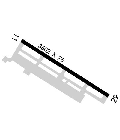
| Lat: N 3815.5 Long: W 12236.3 Elev: 90 Var: -16 Longest Runway: 3600 | ||
| AWOS: 132.32 CTAF: 122.7 | ||
| ||||||||||||||||||||||||||||||||||||||||||||
| ||||||||||||||||||||||||||||||||||||||||||||
| ||||||||||||||||||||||||||||||||||||||||||||
| Rwy | Rwy | |||||||
| 3600x75 | 3600' | 3600x75 | 3600' | |||||
| Runway ID | Single Wheel | Double Wheel | Double Tandem Wheel | Dual Double Wheel |
| 11/29 | 12,500 | N/A | N/A | N/A |
| These numbers are Advisory and are not limits. The Airport Manager should have more accurate Weight Limits | ||||
 Airport Diagram might not be current. | |
| Facility Name: | PETALUMA MUNI |
| City Name: | PETALUMA |
| County: | SONOMA |
| State abbrev: | CA |
| State Name: | CALIFORNIA |
| Ownership: | PUBLICLY OWNED |
| Use: | OPEN TO THE PUBLIC |
| Owner's Name: | CITY OF PETALUMA |
| Address: | PO BOX 61 |
| PETALUMA, CA 94952 | |
| Owner's Phone: | 707-778-4345 |
| Manager's Name: | DANIEL COHEN |
| Address: | 601 SKY RANCH DRIVE |
| PETALUMA, CA 94954 | |
| Phone: | 707-778-4404 |
| FAA Region: | WESTERN-PACIFIC |
| FAA Field Office: | SFO |
| Date | Sunrise | Sunset |
|---|---|---|
| 06/08/26 Monday | 5:47 | 20:32 |
| 06/09/26 Tuesday | 5:47 | 20:33 |
| 06/10/26 Wednesday | 5:47 | 20:33 |
| 06/11/26 Thursday | 5:46 | 20:34 |
| 06/12/26 Friday | 5:46 | 20:34 |
| 06/13/26 Saturday | 5:46 | 20:35 |
| 06/14/26 Sunday | 5:46 | 20:35 |
| 06/15/26 Monday | 5:46 | 20:35 |
| 06/16/26 Tuesday | 5:46 | 20:36 |
| 06/17/26 Wednesday | 5:47 | 20:36 |
| 06/18/26 Thursday | 5:47 | 20:36 |
| 06/19/26 Friday | 5:47 | 20:37 |
| 06/20/26 Saturday | 5:47 | 20:37 |
| 06/21/26 Sunday | 5:47 | 20:37 |
| Airport Attendance Schedule | 7 Days A Week 0800-1700 |
| Airport Status | OPERATIONAL (This Status can change at any time - please check NOTAMS) |
| Airport Lighting Schedule | ACTVT REIL RWY 29; PAPI RWY 29; MIRL RWY 11/29 - CTAF. |
| Airport Storage Available | Tie Downs |
| Extra Services Available | Flight Instruction, Aircraft Rental, Aircraft Sales |
| Wind Indicator | YES - (lighted) |
| Control Tower | NO |
| CTAF Frequency | 122.700 |
| Unicom Frequency | 122.700 |
| Rotating Beacon Color | WG |
| Segmented Circle | YES |
| Landing Fee | NO |
| Airport Inspected | STATE - performed by STATE AERONAUTICAL PERSONNEL |
| Inspection Date | 02/10/2026 |
| Type of Fuel Available | Grade 100LL, JET A (freeze point -40C) |
| Airframe Repair Service | MAJOR |
| Power Plant Repair Service | MAJOR |
| Latitude | N3815.5 |
| Longitude | W12236.3 (ESTIMATED) |
| Arpt Elevation | 90ft (SURVEYED) |
| Magnetic Variation | 16E |
| 1 miles NE | of PETALUMA |
| Traffic Pattern Altitude | |
| Sectional Chart | SAN FRANCISCO |
| Operations (Reported) | Yearly | Avg. Daily |
|---|---|---|
| General Aviation Transient | 0 | 0 |
| General Aviation Local | 0 | 0 |
| Air Taxi | 0 | 0 |
| Commerical | 0 | 0 |
| Commuter | 0 | 0 |
| Military | 0 | 0 |
| Aircraft based on Field | |
|---|---|
| General Aviation Singles | 0 |
| General Aviation Multi | 0 |
| Jet Aircraft | 0 |
| General Aviation Helicopters | 0 |
| Military Aircraft | 0 |
| Gliders | 0 |
| Ultralights | 0 |
| FSS on field | NO |
| FSS tie-in | OAKLAND |
| FSS Phone | 1-800-WX-BRIEF |
| Who issues Notams | OAK |
| Notam D service at airport | YES |
| ARTCC Name | OAKLAND |
| Airport Certification | |
| Aircraft Rescue & Firefighting Index | None |
| Airport of Entry | No |
| Custom Landing Rights | No |
| Joint Civil/Military | No |
| Military Landing rights | No |
| NATIONAL PLAN OF INTEGRATED AIRPORT SYSTEMS (NPIAS) |
| GRANT AGREEMENTS UNDER FAAP/ADAP/AIP |
| ASSURANCES PURSUANT TO TITLE VI, CIVIL RIGHTS ACT OF 1964 |
| NOISE ABATEMENT PROCEDURE 800 FT MSL BEFORE CROSSWIND TURN; STRAIGHT OUT CLIMB TO 1500 FT MSL FOR DEPS; DOWNWIND STAY OUTSIDE ADOBE RD; AVOID OVERFLIGHTS OF THE OLD ODOBE HISTORIC PARK. |
| FOR CD CTC OAKLAND ARTCC AT 510-745-3380. |
| CALM WIND RWY 29. |
Airport Communications & Frequencies:
| |||||||||
| Runway: 11 | Runway: 29 | ||
| Mag heading: | 109° | Mag heading: | 289° |
| Rwy Slope: | -.35% Down | Rwy Slope: | .35% Up |
| Approach: | Approach: | ||
| Pattern: | Left Traffic | Pattern: | Right Traffic |
| Markings: | NONPRECISION INSTRUMENT | Markings: | NONPRECISION INSTRUMENT |
| Marking Condition: | GOOD | Marking Condition: | GOOD |
| Arresting Dev: | Arresting Dev: | ||
| Lat & Long: | N3815.6 W12236.6 | Lat. & Long.: | N3815.3 W12236.0 |
| Elev: | 90.2 ft. MSL | Elev: | 77.5 ft. MSL |
| TCH: | TCH: | 44 ft. AGL | |
| Visual Glide Path: | Visual Glide Path: | 3.00 degrees | |
| Displaced Threshold: | No | Displaced Threshold: | No |
| Touchdown Zone: | YES | Touchdown Zone: | YES |
| Touchdown Elev.: | 90.2 feet | Touchdown Elev.: | 86.3 feet |
| Visual Glide Slope: | Visual Glide Slope: | 4-Light PAPI on LEFT side of Runway | |
| RVR Equipment: | RVR Equipment: | ||
| RVV Equipment: | NO | RVV Equipment: | NO |
| Approach Lights: | Approach Lights: | ||
| REIL: | NO | REIL: | YES |
| Centerline Lights: | NO | Centerline Lights: | NO |
| Touchdown lights: | NO | Touchdown lights: | NO |
| Runway Category: | Runway with a Visual Approach | Runway Category: | Runway with a Non-precision Approach |
| Declared Distances: | Declared Distances: | ||
| Obstructions: | TREES | Obstructions: | |
| Marked: | NOT Marked/Lighted | Marked: | |
| Clearance slope: | 35:1 | Clearance slope: | 50:1 |
| Obstruction height: | 65 feet AGL | Obstruction height: | |
| Dist. from runway: | 2500 feet | Dist. from runway: | |
| Centerline offset: | 150 left of centerline | Centerline offset: | |
| Comments: | Comments: |
Thanks for using FltPlan.com
all rights reserved © 1999-2026 by Flight Plan LLC
