
| ELLS FIELD-WILLITS MUNI WILLITS CA |
| |
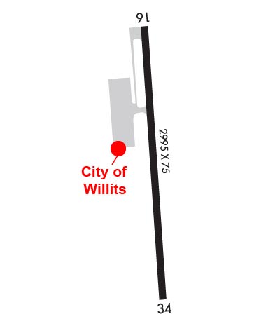
| Lat: N 3927.1 Long: W 12322.3 Elev: 2066 Var: -16 Longest Runway: 2705 | ||
| CTAF: 122.8 | ||
| |||||||||||||||||||||||||||||||||||||||||||||||||||||||||||||
| |||||||||||||||||||||||||||||||||||||||||||||||||||||||||||||
| |||||||||||||||||||||||||||||||||||||||||||||||||||||||||||||
| Rwy | Rwy | |||||||
| 2705x75 | 2705' | 2705x75 | 2705' | |||||
| Runway ID | Single Wheel | Double Wheel | Double Tandem Wheel | Dual Double Wheel |
| 16/34 | 30,000 | N/A | N/A | N/A |
| These numbers are Advisory and are not limits. The Airport Manager should have more accurate Weight Limits | ||||
 Airport Diagram might not be current. | |
| Facility Name: | ELLS FLD/WILLITS MUNI |
| City Name: | WILLITS |
| County: | MENDOCINO |
| State abbrev: | CA |
| State Name: | CALIFORNIA |
| Ownership: | PUBLICLY OWNED |
| Use: | OPEN TO THE PUBLIC |
| Owner's Name: | CITY OF WILLITS |
| Address: | 111 E COMMERCIAL ST. |
| WILLITS, CA 95490 | |
| Owner's Phone: | 707-459-4605 |
| Manager's Name: | CATHY MOORHEAD; EMAIL: KOSHEA@WILLITSAIRPORT.COM |
| Address: | 111 EAST COMMERCIAL STREET |
| WILLITS, CA 95490 | |
| Phone: | 707-459-7121 |
| FAA Region: | WESTERN-PACIFIC |
| FAA Field Office: | SFO |
| Date | Sunrise | Sunset |
|---|---|---|
| 06/07/26 Sunday | 5:46 | 20:38 |
| 06/08/26 Monday | 5:46 | 20:39 |
| 06/09/26 Tuesday | 5:46 | 20:39 |
| 06/10/26 Wednesday | 5:46 | 20:40 |
| 06/11/26 Thursday | 5:46 | 20:40 |
| 06/12/26 Friday | 5:46 | 20:41 |
| 06/13/26 Saturday | 5:46 | 20:41 |
| 06/14/26 Sunday | 5:46 | 20:42 |
| 06/15/26 Monday | 5:46 | 20:42 |
| 06/16/26 Tuesday | 5:46 | 20:43 |
| 06/17/26 Wednesday | 5:46 | 20:43 |
| 06/18/26 Thursday | 5:46 | 20:43 |
| 06/19/26 Friday | 5:46 | 20:43 |
| 06/20/26 Saturday | 5:46 | 20:44 |
| Airport Attendance Schedule | UNATTENDED |
| Airport Status | OPERATIONAL (This Status can change at any time - please check NOTAMS) |
| Airport Lighting Schedule | ACTVT PAPI RWY 34; MIRL RWY 16/34 - CTAF.; DUSK-DAWN. BCN OTS INDEFLY. |
| Airport Storage Available | Tie Downs |
| Extra Services Available | Charter, Flight Instruction, Aircraft Rental, Aircraft Sales |
| Wind Indicator | YES - (lighted) |
| Control Tower | NO |
| CTAF Frequency | 122.800 |
| Unicom Frequency | 122.800 |
| Rotating Beacon Color | WG |
| Segmented Circle | YES |
| Landing Fee | NO |
| Airport Inspected | STATE - performed by STATE AERONAUTICAL PERSONNEL |
| Inspection Date | 07/11/2025 |
| Type of Fuel Available | Grade 100LL; -10FUEL AVBL 24 HRS WITH CREDIT CARD. |
| Airframe Repair Service | MINOR |
| Power Plant Repair Service | MINOR |
| Latitude | N3927.1 |
| Longitude | W12322.3 (ESTIMATED) |
| Arpt Elevation | 2065ft (SURVEYED) |
| Magnetic Variation | 16E |
| 3 miles NW | of WILLITS |
| Traffic Pattern Altitude | |
| Sectional Chart | SAN FRANCISCO |
| Operations (Reported) | Yearly | Avg. Daily |
|---|---|---|
| General Aviation Transient | 0 | 0 |
| General Aviation Local | 0 | 0 |
| Air Taxi | 0 | 0 |
| Commerical | 0 | 0 |
| Commuter | 0 | 0 |
| Military | 0 | 0 |
| Aircraft based on Field | |
|---|---|
| General Aviation Singles | 0 |
| General Aviation Multi | 0 |
| Jet Aircraft | 0 |
| General Aviation Helicopters | 0 |
| Military Aircraft | 0 |
| Gliders | 0 |
| Ultralights | 0 |
| FSS on field | NO |
| FSS tie-in | OAKLAND |
| FSS Phone | 1-800-WX-BRIEF |
| Who issues Notams | OAK |
| Notam D service at airport | YES |
| ARTCC Name | OAKLAND |
| Airport Certification | |
| Aircraft Rescue & Firefighting Index | None |
| Airport of Entry | No |
| Custom Landing Rights | No |
| Joint Civil/Military | No |
| Military Landing rights | YES |
| NATIONAL PLAN OF INTEGRATED AIRPORT SYSTEMS (NPIAS) |
| ASSURANCES PURSUANT TO TITLE VI, CIVIL RIGHTS ACT OF 1964 |
| GRANT AGREEMENT HAS EXPIRED; HOWEVER, AGREEMENT REMAINS IN EFFECT FOR THIS FACILITY AS LONG AS IT IS PUBLIC USE. |
| DEER AND TURKEYS ON AND INVOF RY. |
| ACFT NOT VISIBLE FROM OPPOSITE ENDS OF THE RUNWAY. |
| FOR CD CTC OAKLAND ARTCC AT 510-745-3380. |
Airport Communications & Frequencies:
| |||||||||
| Runway: 16 | Runway: 34 | ||
| Mag heading: | 159° | Mag heading: | 339° |
| Rwy Slope: | -1.39% Down | Rwy Slope: | 1.39% Up |
| Approach: | Approach: | ||
| Pattern: | Left Traffic | Pattern: | Right Traffic |
| Markings: | NONPRECISION INSTRUMENT | Markings: | NONPRECISION INSTRUMENT |
| Marking Condition: | GOOD | Marking Condition: | GOOD |
| Arresting Dev: | Arresting Dev: | ||
| Lat & Long: | N3927.3 W12322.4 | Lat. & Long.: | N3926.9 W12322.3 |
| Elev: | 2065.9 ft. MSL | Elev: | 2028.3 ft. MSL |
| TCH: | TCH: | 21 ft. AGL | |
| Visual Glide Path: | Visual Glide Path: | 3.00 degrees | |
| Displaced Threshold: | No | Displaced Threshold: | No |
| Touchdown Zone: | YES | Touchdown Zone: | YES |
| Touchdown Elev.: | 2065.9 feet | Touchdown Elev.: | 2065.9 feet |
| Visual Glide Slope: | Visual Glide Slope: | 2-Light PAPI on LEFT side of Runway | |
| RVR Equipment: | RVR Equipment: | ||
| RVV Equipment: | NO | RVV Equipment: | NO |
| Approach Lights: | Approach Lights: | ||
| REIL: | NO | REIL: | NO |
| Centerline Lights: | NO | Centerline Lights: | NO |
| Touchdown lights: | NO | Touchdown lights: | NO |
| Runway Category: | Runway with a Non-precision Approach | Runway Category: | Runway with a Non-precision Approach |
| Declared Distances: | Declared Distances: | ||
| Obstructions: | TREES | Obstructions: | TREES |
| Marked: | NOT Marked/Lighted | Marked: | NOT Marked/Lighted |
| Clearance slope: | 3:1 | Clearance slope: | 21:1 |
| Obstruction height: | 11 feet AGL | Obstruction height: | 38 feet AGL |
| Dist. from runway: | 240 feet | Dist. from runway: | 1000 feet |
| Centerline offset: | 80 right of centerline | Centerline offset: | 200 feet right of centerline |
| Comments: | Comments: |
Thanks for using FltPlan.com
all rights reserved © 1999-2026 by Flight Plan LLC

