
| COLUSA COUNTY COLUSA CA |
| |
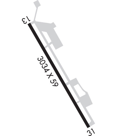
| Lat: N 3910.7 Long: W 12159.6 Elev: 49 Var: -13 Longest Runway: 3034 | ||
| CTAF: 122.8 | ||
| |||||||||||||||||||||||||||||||||||||||||||||||||||||||||||||
| |||||||||||||||||||||||||||||||||||||||||||||||||||||||||||||
| Rwy | Rwy | |||||||
| 3034x59 | 3034' | 3034x59 | 3034' | |||||
| Runway ID | Single Wheel | Double Wheel | Double Tandem Wheel | Dual Double Wheel |
| 14/32 | 10,000 | N/A | N/A | N/A |
| These numbers are Advisory and are not limits. The Airport Manager should have more accurate Weight Limits | ||||
 Airport Diagram might not be current. | |
| Facility Name: | SIDNEY PICKELS FLD |
| City Name: | COLUSA |
| County: | COLUSA |
| State abbrev: | CA |
| State Name: | CALIFORNIA |
| Ownership: | PUBLICLY OWNED |
| Use: | OPEN TO THE PUBLIC |
| Owner's Name: | COUNTY OF COLUSA |
| Address: | COUNTY COURTHOUSE |
| COLUSA, CA 95932 | |
| Owner's Phone: | 530-458-0466 |
| Manager's Name: | COLT ESENWEIN; COUNTY PUB WORKS DIR. ARPT MGR 530-682-2612. |
| Address: | 1215 MARKET ST, SUITE F |
| COLUSA, CA 95932-3246 | |
| Phone: | 530-789-1778 |
| FAA Region: | WESTERN-PACIFIC |
| FAA Field Office: | SFO |
| Date | Sunrise | Sunset |
|---|---|---|
| 06/08/26 Monday | 5:42 | 20:33 |
| 06/09/26 Tuesday | 5:41 | 20:33 |
| 06/10/26 Wednesday | 5:41 | 20:34 |
| 06/11/26 Thursday | 5:41 | 20:34 |
| 06/12/26 Friday | 5:41 | 20:35 |
| 06/13/26 Saturday | 5:41 | 20:35 |
| 06/14/26 Sunday | 5:41 | 20:35 |
| 06/15/26 Monday | 5:41 | 20:36 |
| 06/16/26 Tuesday | 5:41 | 20:36 |
| 06/17/26 Wednesday | 5:41 | 20:37 |
| 06/18/26 Thursday | 5:41 | 20:37 |
| 06/19/26 Friday | 5:41 | 20:37 |
| 06/20/26 Saturday | 5:42 | 20:37 |
| 06/21/26 Sunday | 5:42 | 20:38 |
| Airport Attendance Schedule | 7 Days A Week DAWN-DUSK |
| Airport Status | OPERATIONAL (This Status can change at any time - please check NOTAMS) |
| Airport Lighting Schedule | ACTVT MIRL RWY 14/32 - CTAF. |
| Airport Storage Available | Tie Downs |
| Extra Services Available | Crop Dusting, Charter, Flight Instruction, Aircraft Rental |
| Wind Indicator | YES - (lighted) |
| Control Tower | NO |
| CTAF Frequency | 122.800 |
| Unicom Frequency | 122.800 |
| Rotating Beacon Color | WG |
| Segmented Circle | YES |
| Landing Fee | NO |
| Airport Inspected | STATE - performed by STATE AERONAUTICAL PERSONNEL |
| Inspection Date | 07/03/2025 |
| Type of Fuel Available | Grade 100LL; -10FUEL AVBL BY CREDIT CARD 24/7 |
| Airframe Repair Service | MAJOR |
| Power Plant Repair Service | MAJOR |
| Latitude | N3910.7 |
| Longitude | W12159.6 (ESTIMATED) |
| Arpt Elevation | 49ft (SURVEYED) |
| Magnetic Variation | 13E |
| 3 miles S | of COLUSA |
| Traffic Pattern Altitude | 800 |
| Sectional Chart | SAN FRANCISCO |
| Operations (Reported) | Yearly | Avg. Daily |
|---|---|---|
| General Aviation Transient | 0 | 0 |
| General Aviation Local | 0 | 0 |
| Air Taxi | 0 | 0 |
| Commerical | 0 | 0 |
| Commuter | 0 | 0 |
| Military | 0 | 0 |
| Aircraft based on Field | |
|---|---|
| General Aviation Singles | 0 |
| General Aviation Multi | 0 |
| Jet Aircraft | 0 |
| General Aviation Helicopters | 0 |
| Military Aircraft | 0 |
| Gliders | 0 |
| Ultralights | 0 |
| FSS on field | NO |
| FSS tie-in | RANCHO MURIETA |
| FSS Phone | 1-800-WX-BRIEF |
| Who issues Notams | RIU |
| Notam D service at airport | YES |
| ARTCC Name | OAKLAND |
| Airport Certification | |
| Aircraft Rescue & Firefighting Index | None |
| Airport of Entry | No |
| Custom Landing Rights | No |
| Joint Civil/Military | No |
| Military Landing rights | YES |
| NATIONAL PLAN OF INTEGRATED AIRPORT SYSTEMS (NPIAS) |
| GRANT AGREEMENTS UNDER FAAP/ADAP/AIP |
| ASSURANCES PURSUANT TO TITLE VI, CIVIL RIGHTS ACT OF 1964 |
| BE ALERT TO BLDG 120 FT AGL 1000 FT WEST. |
| (E81) RWY EXIT LGTS ONLY. |
| BIRDS ON AND IN VICINITY OF AIRPORT |
| FOR CD CTC OAKLAND ARTCC AT 510-745-3380. |
Airport Communications & Frequencies:
| |||||||||
| Runway: 14 | Runway: 32 | ||
| Mag heading: | 138° | Mag heading: | 318° |
| Rwy Slope: | -.07% Down | Rwy Slope: | .07% Up |
| Approach: | Approach: | ||
| Pattern: | Left Traffic | Pattern: | Right Traffic |
| Markings: | NONPRECISION INSTRUMENT | Markings: | NONPRECISION INSTRUMENT |
| Marking Condition: | GOOD | Marking Condition: | GOOD |
| Arresting Dev: | Arresting Dev: | ||
| Lat & Long: | N3911.0 W12159.8 | Lat. & Long.: | N3910.5 W12159.4 |
| Elev: | 48.8 ft. MSL | Elev: | 46.8 ft. MSL |
| TCH: | 25 ft. AGL | TCH: | 43 ft. AGL |
| Visual Glide Path: | 3.00 degrees | Visual Glide Path: | 3.00 degrees |
| Displaced Threshold: | No | Displaced Threshold: | No |
| Touchdown Zone: | YES | Touchdown Zone: | YES |
| Touchdown Elev.: | 49.0 feet | Touchdown Elev.: | 49.0 feet |
| Visual Glide Slope: | 2-Light PAPI on LEFT side of Runway | Visual Glide Slope: | 2-Light PAPI on LEFT side of Runway |
| RVR Equipment: | RVR Equipment: | ||
| RVV Equipment: | NO | RVV Equipment: | NO |
| Approach Lights: | Approach Lights: | ||
| REIL: | NO | REIL: | NO |
| Centerline Lights: | NO | Centerline Lights: | NO |
| Touchdown lights: | NO | Touchdown lights: | NO |
| Runway Category: | Runway with a Non-precision Approach | Runway Category: | Runway with a Non-precision Approach |
| Declared Distances: | Declared Distances: | ||
| Obstructions: | Obstructions: | ROAD | |
| Marked: | Marked: | NOT Marked/Lighted | |
| Clearance slope: | 50:1 | Clearance slope: | 16:1 |
| Obstruction height: | Obstruction height: | 15 feet AGL | |
| Dist. from runway: | Dist. from runway: | 450 feet | |
| Centerline offset: | Centerline offset: | 100B | |
| Comments: | Comments: |
Thanks for using FltPlan.com
all rights reserved © 1999-2026 by Flight Plan LLC
