
| NEVADA MUNI NEVADA MO |
| |
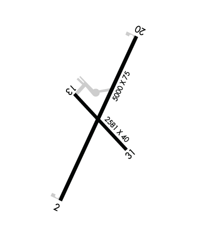
| Lat: N 3751.1 Long: W 09418.3 Elev: 892 Var: -02 Longest Runway: 5000 | ||
| AWOS: 119.17 CTAF: 122.8 | ||
| ||||||||||||||||||||||||||||||||||||||||||||
| ||||||||||||||||||||||||||||||||||||||||||||
| ||||||||||||||||||||||||||||||||||||||||||||
| Rwy | Rwy | |||||||
| 5000x75 | 5000' | 5000x75 | 5000' | |||||
| 2581x40 | 2581' | 2581x40 | 2581' | |||||
| Runway ID | Single Wheel | Double Wheel | Double Tandem Wheel | Dual Double Wheel |
| 02/20 | 20,000 | 42,000 | N/A | N/A |
| 13/31 | 19,000 | N/A | N/A | N/A |
| These numbers are Advisory and are not limits. The Airport Manager should have more accurate Weight Limits | ||||
 Airport Diagram might not be current. | |
| Facility Name: | NEVADA MUNI |
| City Name: | NEVADA |
| County: | VERNON |
| State abbrev: | MO |
| State Name: | MISSOURI |
| Ownership: | PUBLICLY OWNED |
| Use: | OPEN TO THE PUBLIC |
| Owner's Name: | CITY OF NEVADA |
| Address: | 110 S ASH |
| NEVADA, MO 64772 | |
| Owner's Phone: | (417) 448-5504 |
| Manager's Name: | JODY BRYSON |
| Address: | 18098 EAST 54 HIGHWAY |
| NEVADA, MO 65772 | |
| Phone: | (417) 448-5107 |
| FAA Region: | CENTRAL |
| FAA Field Office: | NONE |
| Date | Sunrise | Sunset |
|---|---|---|
| 09/24/21 Friday | 7:06 | 19:11 |
| 09/25/21 Saturday | 7:07 | 19:10 |
| 09/26/21 Sunday | 7:08 | 19:08 |
| 09/27/21 Monday | 7:09 | 19:07 |
| 09/28/21 Tuesday | 7:10 | 19:05 |
| 09/29/21 Wednesday | 7:11 | 19:04 |
| 09/30/21 Thursday | 7:12 | 19:02 |
| 10/01/21 Friday | 7:13 | 19:01 |
| 10/02/21 Saturday | 7:14 | 18:59 |
| 10/03/21 Sunday | 7:14 | 18:58 |
| 10/04/21 Monday | 7:15 | 18:56 |
| 10/05/21 Tuesday | 7:16 | 18:55 |
| 10/06/21 Wednesday | 7:17 | 18:53 |
| 10/07/21 Thursday | 7:18 | 18:52 |
| Airport Attendance Schedule | 7 Days A Week 0730-DUSK |
| Airport Status | OPERATIONAL (This Status can change at any time - please check NOTAMS) |
| Airport Lighting Schedule | ACTVT REILS RWYS 02 & 20; PAPI RWYS 02 & 20; MIRLS RWY 02/20 AFTER SS - CTAF. REILS RWYS 02 & 20; PAPI RWYS 02 & 20; MIRLS RWYS 02 & 20 NOT AVBL SR - SS. |
| Airport Storage Available | Tie Downs |
| Extra Services Available | Crop Dusting |
| Wind Indicator | YES - (lighted) |
| Control Tower | NO |
| CTAF Frequency | 122.800 |
| Unicom Frequency | 122.800 |
| Rotating Beacon Color | CLEAR-GREEN (Light Land Airport) |
| Segmented Circle | YES |
| Landing Fee | NO |
| Airport Inspected | STATE - performed by STATE AERONAUTICAL PERSONNEL |
| Inspection Date | 07/23/2020 |
| Type of Fuel Available | Grade 100LL, JET A (freeze point -40C) |
| Airframe Repair Service | MINOR |
| Power Plant Repair Service | MINOR |
| Latitude | N3751.1 |
| Longitude | W09418.3 (ESTIMATED) |
| Arpt Elevation | 892ft (SURVEYED) |
| Magnetic Variation | 02E |
| 3 miles NE | of NEVADA |
| Traffic Pattern Altitude | |
| Sectional Chart | KANSAS CITY |
| Operations (Reported) | Yearly | Avg. Daily |
|---|---|---|
| General Aviation Transient | 3200 | 9 |
| General Aviation Local | 4000 | 11 |
| Air Taxi | 10 | 0 |
| Commerical | 0 | 0 |
| Commuter | 0 | 0 |
| Military | 100 | 0 |
| Aircraft based on Field | |
|---|---|
| General Aviation Singles | 17 |
| General Aviation Multi | 1 |
| Jet Aircraft | 0 |
| General Aviation Helicopters | 0 |
| Military Aircraft | 0 |
| Gliders | 0 |
| Ultralights | 0 |
| FSS on field | NO |
| FSS tie-in | COLUMBIA |
| FSS Phone | 1-800-WX-BRIEF |
| Who issues Notams | COU |
| Notam D service at airport | YES |
| ARTCC Name | KANSAS CITY |
| Airport Certification | |
| Aircraft Rescue & Firefighting Index | None |
| Airport of Entry | No |
| Custom Landing Rights | No |
| Joint Civil/Military | No |
| Military Landing rights | YES |
| NATIONAL PLAN OF INTEGRATED AIRPORT SYSTEMS (NPIAS) |
| GRANT AGREEMENTS UNDER FAAP/ADAP/AIP |
| ASSURANCES PURSUANT TO TITLE VI, CIVIL RIGHTS ACT OF 1964 |
| WILDLIFE ON & INVOF RY DUSK-DAWN. |
| CROP DUSTING ACFT ON & INVOF ARPT. |
| FOR CD CTC KANSAS CITY ARTCC AT 913-254-8508. |
| RWY 13/3 1 RWY 13/31 PAVEMENT CRACKED WITH LOOSE ASPH CHIPS & VEGETATION GROWING IN CRACKS. |
| RWY 13/3 1 LIMITED BY AMGR TO 8000 LBS SINGLE WHEEL GEAR. |
Airport Communications & Frequencies:
| |||||||||
| Runway: 02 | Runway: 20 | ||
| Mag heading: | 24° | Mag heading: | 205° |
| Rwy Slope: | -.18% Down | Rwy Slope: | .18% Up |
| Approach: | Approach: | ||
| Pattern: | Left Traffic | Pattern: | Left Traffic |
| Markings: | NONPRECISION INSTRUMENT | Markings: | NONPRECISION INSTRUMENT |
| Marking Condition: | FAIR; MARKINGS FADED. | Marking Condition: | FAIR; MARKINGS FADED |
| Arresting Dev: | Arresting Dev: | ||
| Lat & Long: | N3750.8 W09418.5 | Lat. & Long.: | N3751.5 W09418.1 |
| Elev: | 890.0 ft. MSL | Elev: | 881.2 ft. MSL |
| TCH: | 34 ft. AGL | TCH: | 39 ft. AGL |
| Visual Glide Path: | 3.00 degrees | Visual Glide Path: | 3.00 degrees |
| Displaced Threshold: | No | Displaced Threshold: | No |
| Touchdown Zone: | YES | Touchdown Zone: | YES |
| Touchdown Elev.: | 890.0 feet | Touchdown Elev.: | 883.5 feet |
| Visual Glide Slope: | 4-Light PAPI on LEFT side of Runway | Visual Glide Slope: | 4-Light PAPI on LEFT side of Runway |
| RVR Equipment: | RVR Equipment: | ||
| RVV Equipment: | NO | RVV Equipment: | NO |
| Approach Lights: | Approach Lights: | ||
| REIL: | YES | REIL: | YES |
| Centerline Lights: | NO | Centerline Lights: | NO |
| Touchdown lights: | NO | Touchdown lights: | NO |
| Runway Category: | Runway with a Non-precision Approach having visibility minimums greater than 3/4 mile | Runway Category: | Runway with a Non-precision Approach having visibility minimums greater than 3/4 mile |
| Declared Distances: | Declared Distances: | ||
| Obstructions: | TREE | Obstructions: | TREES |
| Marked: | NOT Marked/Lighted | Marked: | NOT Marked/Lighted |
| Clearance slope: | 18:1 | Clearance slope: | 25:1 |
| Obstruction height: | 56 feet AGL | Obstruction height: | 45 feet AGL |
| Dist. from runway: | 1210 feet | Dist. from runway: | 1365 feet |
| Centerline offset: | 302 right of centerline | Centerline offset: | 323 feet right of centerline |
| Comments: | Comments: |
| Runway: 13 | Runway: 31 | ||
| Mag heading: | 133° | Mag heading: | 313° |
| Rwy Slope: | -.12% Down | Rwy Slope: | .12% Up |
| Approach: | Approach: | ||
| Pattern: | Left Traffic | Pattern: | Left Traffic |
| Markings: | Markings: | ||
| Marking Condition: | Marking Condition: | ||
| Arresting Dev: | Arresting Dev: | ||
| Lat & Long: | N3751.3 W09418.4 | Lat. & Long.: | N3751.0 W09418.1 |
| Elev: | 877.0 ft. MSL | Elev: | 874.0 ft. MSL |
| TCH: | TCH: | ||
| Visual Glide Path: | Visual Glide Path: | ||
| Displaced Threshold: | No | Displaced Threshold: | No |
| Touchdown Zone: | YES | Touchdown Zone: | YES |
| Touchdown Elev.: | 877.0 feet | Touchdown Elev.: | 877.0 feet |
| Visual Glide Slope: | Visual Glide Slope: | ||
| RVR Equipment: | RVR Equipment: | ||
| RVV Equipment: | NO | RVV Equipment: | NO |
| Approach Lights: | Approach Lights: | ||
| REIL: | NO | REIL: | NO |
| Centerline Lights: | NO | Centerline Lights: | NO |
| Touchdown lights: | NO | Touchdown lights: | NO |
| Runway Category: | Runway with a Visual Approach | Runway Category: | Runway with a Visual Approach |
| Declared Distances: | Declared Distances: | ||
| Obstructions: | TREES | Obstructions: | TREES |
| Marked: | NOT Marked/Lighted | Marked: | NOT Marked/Lighted |
| Clearance slope: | 16:1 | Clearance slope: | 12:1 |
| Obstruction height: | 39 feet AGL | Obstruction height: | 34 feet AGL |
| Dist. from runway: | 836 feet | Dist. from runway: | 625 feet |
| Centerline offset: | 170 right of centerline | Centerline offset: | 112B |
| Comments: | COUNTY ROAD 189-483 FT FM RY END 125 FT R AND L. | Comments: |
Thanks for using FltPlan.com
all rights reserved © 1999-2021 by Flight Plan LLC
