
| WHIDBEY ISLAND NAS /AULT FIELD OAK HARBOR WA |
| |
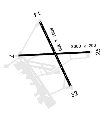
| Lat: N 4821.1 Long: W 12239.4 Elev: 47 Var: -18 Longest Runway: 8001 | ||
| Clr Del: 135.1 Dept. ATIS: 134.15 Arr. ATIS: 134.15 Ground: 121.75 Tower: 127.9 | ||
| ||||||
|
| Rwy | Rwy | |||||||
| 8000x200 | 8000' | 8000x200 | 8000' | |||||
| 8001x200 | 8001' | 110.10 - 136° | 8001x200 | 8001' | ||||
| Runway ID | Single Wheel | Double Wheel | Double Tandem Wheel | Dual Double Wheel |
| 07/25 | N/A | N/A | N/A | N/A |
| 14/32 | N/A | N/A | N/A | N/A |
| These numbers are Advisory and are not limits. The Airport Manager should have more accurate Weight Limits | ||||
 Airport Diagram might not be current. | |
| Facility Name: | WHIDBEY ISLAND NAS /AULT FLD/ |
| City Name: | OAK HARBOR |
| County: | ISLAND |
| State abbrev: | WA |
| State Name: | WASHINGTON |
| Ownership: | NAVY OWNED |
| Use: | PRIVATE |
| Owner's Name: | U S NAVY |
| Address: | OCEANOGRAPHIC OFC CODE 3142 |
| WASHINGTON, D C 20373 | |
| Owner's Phone: | |
| Manager's Name: | COMMANDING OFFICER |
| Address: | NAS WHIDBEY ISLAND |
| OAK HARBOR, WA 98278 | |
| Phone: | 360 257 2681 |
| FAA Region: | NORTHWEST MOUNTAIN |
| FAA Field Office: | SEA |
| Date | Sunrise | Sunset |
|---|---|---|
| 09/24/21 Friday | 7:00 | 19:05 |
| 09/25/21 Saturday | 7:01 | 19:02 |
| 09/26/21 Sunday | 7:03 | 19:00 |
| 09/27/21 Monday | 7:04 | 18:58 |
| 09/28/21 Tuesday | 7:05 | 18:56 |
| 09/29/21 Wednesday | 7:07 | 18:54 |
| 09/30/21 Thursday | 7:08 | 18:52 |
| 10/01/21 Friday | 7:10 | 18:50 |
| 10/02/21 Saturday | 7:11 | 18:48 |
| 10/03/21 Sunday | 7:13 | 18:46 |
| 10/04/21 Monday | 7:14 | 18:44 |
| 10/05/21 Tuesday | 7:15 | 18:42 |
| 10/06/21 Wednesday | 7:17 | 18:40 |
| 10/07/21 Thursday | 7:18 | 18:38 |
| Airport Attendance Schedule | CONTINUOUS |
| Airport Status | OPERATIONAL (This Status can change at any time - please check NOTAMS) |
| Airport Lighting Schedule | AVBL ONLY DURING HRS OF OPERATION. |
| Airport Storage Available | NONE |
| Extra Services Available | NONE |
| Wind Indicator | NONE |
| Control Tower | YES |
| CTAF Frequency | |
| Unicom Frequency | |
| Rotating Beacon Color | SPLIT-CLEAR-GREEN (LIGHTED MILITARY AIRPORT) |
| Segmented Circle | NO |
| Landing Fee |
| Airport Inspected | No Inspection Data Available performed by the OWNER |
| Inspection Date | Unknown |
| Type of Fuel Available | Grade 100LLJ5J8 |
| Airframe Repair Service | None |
| Power Plant Repair Service | None |
| Latitude | N4821.1 |
| Longitude | W12239.4 (ESTIMATED) |
| Arpt Elevation | 47ft (SURVEYED) |
| Magnetic Variation | 18E |
| 3 miles N | of OAK HARBOR |
| Traffic Pattern Altitude | |
| Sectional Chart | SEATTLE |
| Operations (Reported) | Yearly | Avg. Daily |
|---|---|---|
| General Aviation Transient | 0 | 0 |
| General Aviation Local | 0 | 0 |
| Air Taxi | 0 | 0 |
| Commerical | 0 | 0 |
| Commuter | 0 | 0 |
| Military | 0 | 0 |
| Aircraft based on Field | |
|---|---|
| General Aviation Singles | 0 |
| General Aviation Multi | 0 |
| Jet Aircraft | 0 |
| General Aviation Helicopters | 0 |
| Military Aircraft | 0 |
| Gliders | 0 |
| Ultralights | 0 |
| FSS on field | NO |
| FSS tie-in | SEATTLE |
| FSS Phone | 1-800-WX-BRIEF |
| Who issues Notams | NUW |
| Notam D service at airport | YES |
| ARTCC Name | SEATTLE |
| Airport Certification | |
| Aircraft Rescue & Firefighting Index | None |
| Airport of Entry | No |
| Custom Landing Rights | No |
| Joint Civil/Military | No |
| Military Landing rights | No |
| SEE FLIP AP/1. |
| CSTMS/AG/IMG: 48 HR PN REQ, CTC AIR TERMINAL SUPERVISOR, 1430-0100Z++ AT DSN 820-2604/6707, C360-257-2604/6707. |
| SERVICE- JASU - 1 (NC-10C), 1 (GTC-85/GTE-85), 1(MSU-200NAV/ A/U47A-5 FUEL-J8 FLUID-SP PRESAIR DE-ICE (2 HR PN REQ) LHOX TRAN ALERT- TRAN CREWS MUST PROVIDE TECHNICAL DIRECT/ASSISTANCE IN SVC/MAINT TO INCLUDE DIRECT SUPERVISION OF FUELING. LTD SVC/MAINT AVBL 1500-2300Z++ MON-FRI. NO MAINT SAT, SUNAND HOL. AIR TERMINAL OPR 1400-0200Z++, AS RQR OT. |
| OLS LENSES AVBL TO ALL RWY. |
| HIRL AND SFL UNAVBL TO RWY 7. RCLL AVBL TO RWY 14-32 ONLY. |
| OPERATIONS DUTY OFFICER C360-257-2681, DSN 820-2681. |
| FOR CIVIL AIRCRAFT LANDING PERMITS (CALP) REQUESTS CTC OPS DUTY OFFICER. |
| RSTD: PPR REQUIRED FOR ALL ACFT EXC SAR/MEDEVAC. CTC AIR TERMINAL SUPERVISOR, 1430-0100Z++ AT DSN 820-2604/6707, C360-257-2604/6707. PRIOR COORD/FLT ADVSY RQR FOR AMC/JOSAC/NALO MSN. |
| TFC PAT - OVERHEAD INITIAL FOR RWYS 7, 14, 32 4NM 2500', RWY 25 6NM 3000'; OVERHEAD BREAK 1500'; PATTERN ALT 1000'. |
| RWY 14/3 2 RY 13/31 PORTION OF SE END BTN 3000 & 2000 FT REMAINING MKR NOT FULLY VISIBLE FM ATCT. |
Airport Communications & Frequencies:
| ||||||||||||||||||||||||||||||||||||||||||||||||||
| Runway: 07 | Runway: 25 | ||
| Mag heading: | 69° | Mag heading: | 249° |
| Rwy Slope: | .07% Up | Rwy Slope: | -.07% Down |
| Approach: | Approach: | ||
| Pattern: | Left Traffic | Pattern: | Left Traffic |
| Markings: | PRECISION INSTRUMENT | Markings: | PRECISION INSTRUMENT |
| Marking Condition: | GOOD | Marking Condition: | GOOD |
| Arresting Dev: | E28 | Arresting Dev: | E28 |
| Lat & Long: | N4821.1 W12240.4 | Lat. & Long.: | N4821.1 W12238.4 |
| Elev: | 18.3 ft. MSL | Elev: | 23.9 ft. MSL |
| TCH: | TCH: | ||
| Visual Glide Path: | Visual Glide Path: | ||
| Displaced Threshold: | No | Displaced Threshold: | No |
| Touchdown Zone: | YES | Touchdown Zone: | YES |
| Touchdown Elev.: | 25.0 feet | Touchdown Elev.: | 27.7 feet |
| Visual Glide Slope: | Visual Glide Slope: | ||
| RVR Equipment: | RVR Equipment: | ||
| RVV Equipment: | NO | RVV Equipment: | NO |
| Approach Lights: | Approach Lights: | ALSF1 - standard 2,400 foot high intensity approach lighting system with sequenced flashers, Category I | |
| REIL: | NO | REIL: | NO |
| Centerline Lights: | NO | Centerline Lights: | NO |
| Touchdown lights: | NO | Touchdown lights: | NO |
| Runway Category: | Runway Category: | ||
| Declared Distances: | Declared Distances: |
| Runway: 14 | Runway: 32 | ||
| Mag heading: | 137° | Mag heading: | 317° |
| Rwy Slope: | .10% Up | Rwy Slope: | -.10% Down |
| Approach: | ILS/DME | Approach: | |
| Pattern: | Left Traffic | Pattern: | Left Traffic |
| Markings: | PRECISION INSTRUMENT | Markings: | PRECISION INSTRUMENT |
| Marking Condition: | GOOD | Marking Condition: | GOOD |
| Arresting Dev: | E28 | Arresting Dev: | E28 |
| Lat & Long: | N4821.7 W12239.8 | Lat. & Long.: | N4820.5 W12238.9 |
| Elev: | 39.3 ft. MSL | Elev: | 47.4 ft. MSL |
| TCH: | TCH: | ||
| Visual Glide Path: | Visual Glide Path: | ||
| Displaced Threshold: | No | Displaced Threshold: | No |
| Touchdown Zone: | YES | Touchdown Zone: | YES |
| Touchdown Elev.: | 39.3 feet | Touchdown Elev.: | 47.4 feet |
| Visual Glide Slope: | Visual Glide Slope: | ||
| RVR Equipment: | RVR Equipment: | ||
| RVV Equipment: | NO | RVV Equipment: | NO |
| Approach Lights: | ALSF2 - standard 2,400 foot high intensity approach lighting system with sequenced flashers, Category II or III | Approach Lights: | ALSF2 - standard 2,400 foot high intensity approach lighting system with sequenced flashers, Category II or III |
| REIL: | NO | REIL: | NO |
| Centerline Lights: | YES | Centerline Lights: | YES |
| Touchdown lights: | YES | Touchdown lights: | NO |
| Runway Category: | Runway Category: | ||
| Declared Distances: | Declared Distances: |
Thanks for using FltPlan.com
all rights reserved © 1999-2021 by Flight Plan LLC
